
Belgrano, Buenos Aires
You can help expand this article with text translated from the corresponding article in Spanish. (February 2012) Click [show] for important translation instructions.
|
Belgrano | |
|---|---|
River Plate Stadium . | |
|
ART ) |
Belgrano is a northern and leafy
Location
The barrio of Palermo is to the southeast; Núñez is to the northwest; Coghlan, Villa Urquiza, Villa Ortúzar and Colegiales are to the southwest.
History

Belgrano was named after Manuel Belgrano, a politician and military leader who created the national flag of Argentina. In 1820, at Belgrano's death, Buenos Aires' legislature introduced a law to name the next town to be founded after him. This happened in 1855, when the Buenos Aires government, fearful that relatives of Juan Manuel de Rosas would dispute the governmental decision to expropriate Rosas' lands, laid down a new town on part of it and named it Belgrano. The town was declared a city shortly thereafter, due to its booming growth, and in 1880 it became the nation's capital for a few weeks, because of the dispute between the national government and Buenos Aires province for the status of the city of Buenos Aires. It was in Belgrano that the law declaring Buenos Aires as Argentina's federal capital was issued.

In 1887, the federal district was enlarged by the annexation of the towns (partidos) of Belgrano and Flores.
Subsections

Belgrano is an upper-middle-class neighborhood that can be roughly divided into Belgrano R, Belgrano C, central Belgrano, and Lower Belgrano (Bajo Belgrano). The heart of the barrio pulses with life on its main thoroughfare, Avenida Cabildo, which runs Northwest to Southeast; the
Avenida Cabildo carries heavy automobile traffic, and features corner cafés, grocery stores, movie theaters, specialty shops, clothing boutiques, bookstores, and other retail venues. Thanks to its wide sidewalks, pedestrians are especially numerous on weekend afternoons as Porteños (residents of Buenos Aires) from various areas of the city come to shop.
Most of the neighborhood's densest housing is located in the vicinity of Cabildo. High-rise luxury apartment buildings are clustered on the leafy streets surrounding the

West of Crámer avenue, "Belgrano R" is chiefly residential and lower-density in nature, characterized by calm streets lined with large, mature shade trees. Most buildings in this section are detached single-family homes that follow North American architectural styles; some residences have sizable backyards with swimming pools. This section is favored by wealthy Argentines and expatriate businesspeople, and also by the embassies of Egypt, Japan, Republic of Korea, Tunisia, United Arab Emitates, among others. Some expensive private, bilingual schools are located in the area.
"
Transportation
Other than Cabildo, avenues Libertador, Luis Maria Campos, Crámer, Ricardo Balbín (formerly known as del Tejar), and Figueroa Alcorta run parallel to the riverbank, while Federico Lacroze, Juramento, Monroe and Congreso run from the riverbank to the Southwest direction. Belgrano is served by the Buenos Aires metro

Notable attractions
The lush park Barrancas de Belgrano was designed by the famous French-Argentine landscape/park architect
On Manuel Belgrano square, a local artisan fair is held regularly, and becomes especially vibrant on weekends. It features a small bust of Manuel Belgrano on its middle spot.
In the edge of the plaza lies the
Image gallery

-
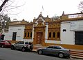
 Domingo Sarmiento Historical Museum
 -
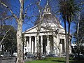
 Gazebo at Barrancas Park
 -
-

-
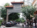 Entrance toChinatown
 -


References
- ^ "The emblems of the 48 barrios of Buenos Aires were presented" Archived 2016-03-13 at the Wayback Machine (Spanish) by ámbito.com Archived 2011-12-13 at the Wayback Machine August 29, 2011
External links
 Media related to Belgrano, Buenos Aires at Wikimedia Commons
 Buenos Aires/Outskirts travel guide from Wikivoyage
| International | |
|---|---|
| National | |