
Belle Haven, Fairfax County, Virginia
Belle Haven, Fairfax County, Virginia | ||
|---|---|---|
FIPS code 51-05928 | | |
| GNIS feature ID | 2389195 | |

Belle Haven is a census-designated place (CDP) in Fairfax County, Virginia, United States. Nearby CDPs are Huntington (northwest), Groveton (southwest) and Fort Hunt (south). The population of Belle Haven was 6,851 at the 2020 census.[1]
The CDP is located just south of
History
The name "Belle Haven" derives from when Scottish pioneers settled along the Potomac River in the early 18th century. They named the settlement after their favorite countryman, the Earl of Belhaven. This early settlement thrived along the Potomac River as a port and was later renamed "Alexandria". The area later became part of the West Grove Plantation, which was built by Hugh West around 1748. It capitalized on its close and favorable position to the newly forming town of Alexandria.[2]
The West family was important in Virginia and Fairfax County politics in the 18th century. Hugh West himself was a burgess from Fairfax County, a vestryman, and a trustee of the town of Alexandria. His son, John, followed in his father's footsteps with continued public work until he died in 1777.[3]
The home passed from the West family in 1814 to a Col. Augustine J. Smith, who bought the plantation from the last West, James, who died in 1814. Smith is known to have enlarged the original 155 acres (63 ha) to over 1,800 acres (730 ha). This included the draining of the swamps along the Potomac River and building a dike. This increased his land holding considerably, but the embankments were cut after his death and never repaired. He is also known for his vast building spree, where he had no less than thirteen new buildings built for the much enlarged plantation. These included larger slave quarters for the forty slaves he owned.[3]
Smith died in 1830, and after several years the plantation was sold to Dennis Johnston. He did little enlarging to the plantation, still known as West's Grove. He was probably kept busy repairing all of Smith's additions. Johnston died several years before the
The current Belle Haven residential community had its start in the 1920s when David Howell, a civil engineer from Alexandria, purchased the land from owners Mrs. Thomas Wilfred Robinson, Sr. and her brothers. Upon purchasing the land, Howell set up two corporations, one to construct a golf course and club, and the other to develop a residential subdivision. The golf course and club later became the Belle Haven Country Club, which still exists.[2]
Geography
Belle Haven is located in eastern Fairfax County at 38°46′44″N 77°3′39″W / 38.77889°N 77.06083°W (38.779013, −77.060721).[4] The eastern border of the community is in the Potomac River and is the state border with Maryland. The northern border follows tidal Hunting Creek and is with the city of Alexandria.
According to the United States Census Bureau, the CDP has a total area of 2.9 square miles (7.4 km2), of which 2.0 square miles (5.1 km2) is land and 0.89 square miles (2.3 km2), or 30.93%, is water.[5]
Belle Haven is located 20 minutes outside of Washington, D.C.
Demographics
2020 Census
At the
Of the family households, 48.1% were married couples, 22.2% were a male family householder with no spouse, and 26.8% were a female family householder with no spouse. The average family household had 3.15 people.[1]
The median age was 41.5, 24.4% of people were under the age of 18, and 16.1% were 65 years of age or older. The largest ancestry is the 28.1% who had
The median income for a household in the CDP was $129,495, and the median income for a family was $190,469. 9.2% of the population were
2010 Census
The population of Belle Haven was 6,518 at the 2010 census.[5]
2000 Census
As of the
There were 3,116 households, out of which 19.5% had children under the age of 18 living with them, 40.7% were married couples living together, 7.5% had a female householder with no husband present, and 49.6% were non-families. 41.8% of all households were made up of individuals, and 9.6% had someone living alone who was 65 years of age or older. The average household size was 2.01, and the average family size was 2.77.
In the CDP, the population was spread out, with 17.2% under the age of 18, 4.1% from 18 to 24, 35.0% from 25 to 44, 28.8% from 45 to 64, and 14.9% who were 65 years of age or older. The median age was 41 years. For every 100 females, there were 87.3 males. For every 100 females age 18 and over, there were 83.5 males.
The median income for a household in the CDP was $65,262, and the median income for a family was $92,195. Males had a median income of $55,446 versus $42,485 for females. The
Population history of Belle Haven CDP from the U.S. Census Bureau
- 1980...6,520
- 1990...6,427
- 2000...6,269
- 2010...6,518
- 2020...6,851
Gallery
-
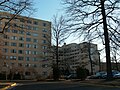 River Towers condominium complex
 -
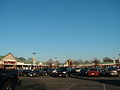 Belle View Shopping Center
 -
 Belle View Condominium Association Management Office
 -
 Bower which forms the centerpiece of the Belle View Town Square
 -
 Creek which runs through Belle View
 -
 Along the George Washington Memorial Parkway in Belle View
 -
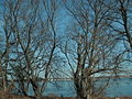
 Belle Haven Park, along the river
 -
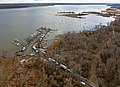 Aerial view of Bell Haven Marina
 -
 The Belle Haven Marina
 -
 Belle View Condominiums


References
- ^ a b c d e "Belle Haven CDP, Virginia". data.census.gov. Retrieved January 26, 2024.
- ^ a b Belle Haven Country Club Historical files
- ^ a b c The Alexandria Gazette. The George Washington Ball map, and various Edith Sprouse articles on local history.
- ^ "US Gazetteer files: 2010, 2000, and 1990". United States Census Bureau. February 12, 2011. Retrieved April 23, 2011.
- ^ a b "Geographic Identifiers: 2010 Demographic Profile Data (G001): Belle Haven CDP, Virginia". U.S. Census Bureau, American Factfinder. Retrieved September 22, 2016.[dead link]
- ^ "U.S. Census website". United States Census Bureau. Retrieved January 31, 2008.

| International | |
|---|---|
| National | |