
Bengaluru Pete
Bengaluru | |
|---|---|
Neighbourhood | |
UTC+5:30 (IST ) |

Bengaluru Pete is the area of
The Bengaluru Pete, established in 1537 around the Mud Fort, built by Kempe Gowda I as the nucleus, with an area of 2.24 square kilometres (1 sq mi), has expanded to the present sprawling city of 741 square kilometres (286 sq mi) embracing a multi
The old Pete, structured in the contemporary style of deep networks of crowded streets, richly represented the multi cultural identity, social history, and economic geography of the times which are considered as a hallmark in the planning and design of any urban agglomerate. The place has left its mark on literature with novels like Riddle of the Seventh Stone[5] being set in this part of Bangalore. These attributes have been further accentuated in the present day Bangalore city.[1] It is now the third largest metropolis in India,[6] the largest city in Karnataka state and the 28th largest city in the world.[7]
History
Even though historically Bengaluru is chronicled to the period of 900 AD, but with confirmed history of the Bengaluru Pete traced to 1537, when Kempe Gowda I (pictured), a Chieftain of the Vijayanagara Empire, widely held as the founder of modern Bangalore, built a mud fort and established the area around it as his province. He was the great-grandson of Jaya Gowda who established the Yelahankanada Prabhu clan, in 1418 AD, and whose principality was in Yelahanka, north of the present day Bangalore.[8] Kempegowda I, who showed remarkable qualities of leadership from his childhood, had a grand vision to build a new city which was further fueled by his visits to

Kempegowda moved from his ancestral land of

Thereafter, he constructed a
It has also been reported that Guru Nanak, the 1st Sikh Guru, on his way back from Sri Lanka halted at Bangalore. Kempegowda met him and sought his blessings. Guru Nanak not only blessed Kempegowda but also advised him to develop the place.[11]
- The Pete
The Pete as built by Kempegowda I had two main streets, namely the Chikkapet Street, which ran east–west, and the Doddapet Street, which ran north–south. Their intersection formed the Doddapete Square (present Avenue road), the heart of Bangalore.[12] Halasoor, also called

- The fort extends from 'Binny Mill' in the west to the AnjaneyaTemple (pictured) near Mysore Bank in the north to Prof. Shivashankar Circle (near Fort High School) in the south.
- The main street extends from Sunakkalpet Circle in the east to the Goodshed Road in the west and this stretch is now known as Old Taluk Kacheri Road.
- The main street of the Pete from Avenue Road (Doddapete Road) in the north to Krishna Rajendra (KR) Road in the south.[9]
Temples and lakes were planned and residential layouts, or agraharas (residential areas of
The visionary approach of the Kempe Gowdas, perceiving the needs of the growing population of the Pete, resulted in building a number of lakes/ponds (called 'Kere' in the Kannada language) and temples (some are pictured in the gallery) in and around the fort. Some of the notable ones are :[9]
- The lakes in the inner circle are the Kempe Gowda Agrahara, Siddikatte, Sampangi, Dharmambudhi, Kempambudhi kere, and Karanji.
- The outer circle lakes were the Yediyur, Chennamma, Mavalli, Akki Thimmana halli, Jakkaraya kere. Most of the lakes have been encroached upon for the present urban needs.
- The early temples built or improved were the Vinayakaand Kalabhairava.
- Pete expansion
With the decline of the rule of the Kempegowdas' clan, the
The Pete initially developed as a pedestrian precinct with the public spaces evolving with
During the colonial rule the British expanded the Pete, to include the cantonment to position their garrison, which was separated by an 11.5 kilometres (7 mi) wide strip of open land. The colonial city by coincidence decongested the old native city (Pete) and also provided much needed green 'lung space'.[13] Since then several developments, post independence (1947 till date), have led to the rapid growth of the city.
- Old Stories
From the time of Kempegowda, the caste leaders assumed the functions of policing and rendering justice, with inter-caste disputes being usually settled in favor of the upper castes. In the 19th century, when the Bangalore Cantonment assumed dominance in terms of size and revenue, care was taken to ensure that there was very little or no contact between the Cantonment areas and the peté, with the Bangalore Cantonment being part of the British Madras Presidency and the Pete being under the administration of the Mysore Maharaja. In 1834, when Mark Cubbon, took over as the Commissioner of Mysore, one of his first task was to establish a legal system based on English Common Law, which ran parallel to the caste-based panchayats. With the establishment of the supremacy of the British courts, the significance of the traditional caste-based courts in the peté began to decline.[14]
Nineteenth-century accounts
P Ballahkristnah's description, 1853
Writing on 7 April 1853, P Ballahkristnah, a Hindu scholar of the Wesleyan Educational Institution, Bangalore, provides a description of the Bangalore Petah. Bangalore is a table-land, offering Europeans travelers from Madras, much relief with the cooler climate. Fruits, vegetables, grains of many varieties grew abundantly. The Bangalore pettah is fully surrounded by tanks, which are artificial lakes used to supply water to the population of the petah. From the outskirts, the Petah looked like it had been recently destroyed by fire and fully de-populated, because of its bare mud walls. However, entering the gates, one finds a bustling city with huge crowds and busy market place. The lanes were narrow, covered with mud and dirt. Drains had been constructed by the Mysore Government at public expense, however, they were badly maintained and seeing bandicoots, rats, carcasses of dead dogs and stagnant water was common. The houses were like dungeons or dark cellars, without any light or ventilation. Singing mosquitoes, poisonous scorpions were common in these native houses. Bargaining was common in the shops, with the vendors quoting different prices for the goods according to how rich or poor the customer looked. Drunkenness was also common in the Bangalore Petah, across all classes of people.[15]
Walker and Walker's account, 1855
According to the Gazetteer of Southern India (1855), the Bangalore Petah is located south west of the
Thomas Hodson's account, 1856
-
![Fort and Pettah of Bangalore (p. 139, 1849)[19]](//upload.wikimedia.org/wikipedia/commons/thumb/8/89/Fort_and_Pettah_of_Bangalore_%28p.139%2C_1849%29_-_Copy.jpg/390px-Fort_and_Pettah_of_Bangalore_%28p.139%2C_1849%29_-_Copy.jpg) Fort and Pettah of Bangalore (p. 139, 1849)[19]
Fort and Pettah of Bangalore (p. 139, 1849)[19] -
![A Bazar, or Shop, in One of the Principal Streets of Bangalore (p. 97, 1856)[18]](//upload.wikimedia.org/wikipedia/commons/thumb/9/9d/A_Bazar%2C_or_Shop%2C_in_One_of_the_Principal_Streets_of_Bangalore_%28p.97%2C_1856%29_-_Copy.jpg/349px-A_Bazar%2C_or_Shop%2C_in_One_of_the_Principal_Streets_of_Bangalore_%28p.97%2C_1856%29_-_Copy.jpg) A Bazar, or Shop, in One of the Principal Streets of Bangalore (p. 97, 1856)[18]
A Bazar, or Shop, in One of the Principal Streets of Bangalore (p. 97, 1856)[18] -
![The Main Street of the Pettah, Bangalore, 1890[20]](//upload.wikimedia.org/wikipedia/commons/thumb/f/fb/The_Main_Street_of_the_Pettah%2C_Bangalore_-_Copy.jpg/148px-The_Main_Street_of_the_Pettah%2C_Bangalore_-_Copy.jpg) The Main Street of the Pettah, Bangalore, 1890[20]
The Main Street of the Pettah, Bangalore, 1890[20] -
![The Dodda Pet, Bangalore (Caine, 1891, p. 523)[21]](//upload.wikimedia.org/wikipedia/commons/thumb/2/24/The_Dodda_Pet%2C_Bangalore_%28Caine%2C_1891%2C_p.523%29_-_Copy.jpg/367px-The_Dodda_Pet%2C_Bangalore_%28Caine%2C_1891%2C_p.523%29_-_Copy.jpg) The Dodda Pet, Bangalore (Caine, 1891, p. 523)[21]
The Dodda Pet, Bangalore (Caine, 1891, p. 523)[21]
![Fort and Pettah of Bangalore (p. 139, 1849)[19]](/File:Fort_and_Pettah_of_Bangalore_(p.139,_1849)_-_Copy.jpg)
![A Bazar, or Shop, in One of the Principal Streets of Bangalore (p. 97, 1856)[18]](/File:A_Bazar,_or_Shop,_in_One_of_the_Principal_Streets_of_Bangalore_(p.97,_1856)_-_Copy.jpg)
![The Main Street of the Pettah, Bangalore, 1890[20]](/File:The_Main_Street_of_the_Pettah,_Bangalore_-_Copy.jpg)
![The Dodda Pet, Bangalore (Caine, 1891, p. 523)[21]](/File:The_Dodda_Pet,_Bangalore_(Caine,_1891,_p.523)_-_Copy.jpg)
Sarah Sanderson's account, 1858 and 1859
_-_Copy.jpg)

Writing on 24 November 1858, Sarah Sanderson (wife of Rev.
Further, Sarah Sanderson, writing on 24 September 1859, describes the pettah as the native town of Bangalore with a population of about 60,000. The petah had nearly 200-300 temples or shrines, whose deities were anointed with oil making them greasy and black, and offered flowers and fruit. The petah now had 2 Christian churches, one was the London Mission Canarese Chapel (now Rice Memorial Church on Avenue Road) and the other was the Canarese Wesleyan Chapel opened a few months before September 1859. To the left of the Wesleyan Chapel was a low building, which had been altered and white-washed to serve as a school. The chapel did not have pews or a gallery. The floor was covered with bamboo matting, and there were rows of benches with seats of fancy cane-work (or rattan). 8 oil lamps using coconut oil were suspended from the ceiling to be used to lighting in the evenings. The windows which were generally kept open had iron bars to keep out the monkeys. Further, she says that her children liked walking the busy streets of the petah to reach the chapel along with their father, observing its noise, local people, shops and the monkeys. Monkeys were numerous in the Petah, and created nuisance by stealing food and other things from people.
Sarah describes some events such as a postman walking up to the pulpit to deliver a letter to the preacher in the middle of his sermon on a Sunday. Another, when the Muslim mourning of 'Moharrum' was being observed when she attended church one evening. The people used to walk in and out of the chapel as they pleased. All so different from the quiet atmosphere of any Wesleyan Chapel in England.[23]
Present urban status of pete
The Pete as it exists today (overlay map) in the heart of Bangalore Metropolis reported a population of 112,076 persons in a diverse use area (Residential: 37.5%; Commercial: 34.6%; Industrial: 6.1%). The trades which defined the Pete in the past have remained but have enormously prospered with modern trades, as distinct entities with a built-in relationship between occupation and community with deep-rooted traditional patterns of living. An urban infrastructure study reported in a scholarly article by Champaka Rajagopal in the Journal of the Development and Research Organization for Nature Arts has the following remarkable observations.[1]
- The Pete is presently, inhabited mainly by people from the Jaincommunities.
- In the Pete, industrial and trade activities overflow into the streets, and incredibly encroach public space.
- Within the Pete precincts, the Gujarati, Marwari and Jain communities from northwestern parts of the country, generally bankers, have gradually diversified their trade from druggists, cutlery, metal, hardware and electrical goods.
- Medarpet is home to the more than 500 families of the Rajput Singh community having their Gurudwara Durbar Saheb Sangh built in memory of Shri Charan Singh Gujar. They make household plastic goods, and medarpete is the wholesale market for Plastic house hold goods.
- Marwaris of the Pete, for whom families still control inheritance and management of their own businesses, have diversified into several trades -– including assembly of computers-– serving new markets.
- Muslim communities of Kumbarpet, like the takaras (traders in household construction industry.
- In the Tharagupet area hardware dealers (mostly dominated by Muslims) say that they have benefited greatly by the rise in global markets, particularly in the construction industry.
- In spite of diversification of trade and industry, most of the areas within the Pete have retained their strong presence of community based occupations such as:
- pawn brokering
- Krishna Rajendra (KR) Market is known for trade in vegetables, utensils
- Sultanpete trades in paper and in Cubbonpete trade is in textiles
- All the above informal industries of the Pete are reported to have generated more jobs for people. The garment industry, in particular, has registered a volume of exports more than Information Technology.
- According to the Comprehensive Development Plan (CDP) of Bangalore, 1995 that determines zoning, land use and transport within Bangalore Metropolitan Area (which has zoned 1,306 square kilometres (504 sq mi) area of the Bangalore Development Authority), has zoned the city into intensely developed (Zone A), moderately developed (Zone B) and sparsely developed (Zone C) areas. The Pete falls within the intensely developed zone.
- The existing trends of development in the Pete is of a highly built up area and a population density that has resulted in less liveable conditions
- A detail study of the changing socio–economic patterns that could bring about in reality different development patterns, is essential by introducing new building byelaws by the municipal corporation
- . Therefore, the Pete skirts through formal enforceable legal systems but continues to develop in an alternative, less liveable way due to strong local politics.
The paper has chronicled the urban planning involving highly intertwined issues of the "pete" succinctly and the conclusion drawn from this study of the Pete is better reflected, as quoted:
"For a place as intricate and complex as the Pete, formulation of regulations through public participation would be sensitive and challenging. Communities, religions and economies have coexisted here but not without tensions… an inclusive methodology would help direct the role of the urban designer as a 'less cavalier' coordinator, addressing diverse disciplines and negotiating the efforts of various groups that shape urban places, especially for informal urban settings such as the Pete."[24]
Gallery
-
 Anjaneyatemple built by Kempegodas at the Avenue (Doddapete) road crossing
 -
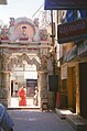 Arch entrance of a Jain temple in Chickpet
 -
 View of K R Market on a weekday.
 -
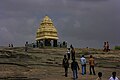
 Entrance of the ancient Sri Gavi Gangadareshwara Temple (cave temple) renovated by Kempegowdas
 -
 Kote srinivasa temple near the Fort
 -
 Tippu Sultan's palace in Bangalore built in 1761, next to the Srinivasa temple, near the old Fort
 -
-
 TheNandi Templeor Bull Temple is a famous temple located in the suburbs of the pete built during Kempegowdas rule
 -
 Wodeyars of the rulers of Mysorein the 19th century
 -
 Bangalore City market near the old Fort
 -
 K.R. Market, Bangalore.


_above_the_caves_of_the_main_shrines_of_Gavigangadreswara_temple_in_Bangalore.jpg)


See also
- K. R. Market
- Kempegowda I
- Bangalore Fort
- Lalbagh
References
- ^ a b c d e f g Rajagopal, Champaka (Spring–Summer 2008). "Bangalore: The informal economy of the Historic Pete" (PDF). Journal of the Development and Research Organization for Nature Arts and Heritage. V (1). Indian Heritage Cities Network: 137–46. Retrieved 7 February 2009.
- ^ "Census population" (PDF). Census of India. www.cicred.org. pp. 6&21. Retrieved 7 March 2009.
- ^ "Bangalore". Archived from the original on 29 June 2011. Retrieved 6 March 2009.
- ^ a b "About Bangalore". Department of Bangalore IT and Biotechnology, Government of Karnataka. Archived from the original on 19 September 2006. Retrieved 5 March 2009.
- ^ Madhukar, Jayanthi (18 October 2010). "Into B'lore's underbelly". Bangalore Mirror. Archived from the original on 7 October 2011. Retrieved 29 May 2012.
- ^ "India: largest cities and towns and statistics of their population". World Gazetteer. Retrieved 7 March 2009.[dead link]
- ^ "World: largest cities and towns and statistics of their population". World Gazetteer. Archived from the original on 1 October 2007. Retrieved 7 March 2009.
{{cite journal}}: Cite journal requires|journal=(help) - ^ "Banaglore". Archived from the original on 4 December 2008. Retrieved 5 March 2009.
- ^ a b c d "A grand dream". The Hindu. Chennai, India. 18 July 2002. Archived from the original on 1 July 2003. Retrieved 6 March 2009.
- ^ a b c "Kempe Gowdas of Bengalooru (Bangalore) by Dr. R. Narayana". Volkkaliga Parishat of America (VPA) –web pagemyvpa.org. Retrieved 6 March 2009.
- ^ "Multiple City:Writings On Bangalore edited by Aditi De,Part III, Article 9, The Cities Within – New Shoes and Old Roots: The Cultural Backdrop of Bangalore by Chiranjeevi Singh,pages 49–59". Penguin Books India,New Delhi. 2008. Archived from the original on 23 January 2013. Retrieved 12 March 2009.
- ISBN 81-206-0977-8. Retrieved 7 March 2009.
- ^ hdl:10919/9941. Archived(PDF) from the original on 5 June 2012. Retrieved 26 September 2020.
- ^ Krishnaswami, Narayanan; Veerappa, Manuja (12 July 2015). "Petes in flux". The Times of India. No. Bangalore. The Times of India. Retrieved 14 July 2015.[dead link]
- ^ Ballahkristnah, P (May 1853). "Description of the City of Bangalore". The Wesleyan Juvenile Offering: A Miscellany of Missionary Information for Young Persons. X. Wesleyan Missionary Society: 124–127. Retrieved 29 February 2016.
- ^ Walker, John; Walker, Charles (1855). A Gazetteer of Southern India: With the Tenasserim Provinces and Singapore. Madras: Pharoah and Co. pp. 562–3. Retrieved 25 November 2015.
wesleyan chapel bangalore cantonment.
- ^ Hodson, Thomas (July 1857). "Bangalore: Wesleyan Wayside Preaching-Place". Wesleyan Juvenile Offering. XIV. London: Wesleyan Mission-House: 72–74. Retrieved 11 November 2015.
- ^ a b Hodson, Richard G (September 1856). "A Bazar, or Shop, in One of the Principal Streets of Bangalore". Wesleyan Juvenile Offering. XIII. London: Wesleyan Mission House. Retrieved 10 November 2015.
- ^ "Fort and Pettah of Bangalore". Wesleyan Juvenile Offering. VI. London: Wesleyan Mission-House. 1849. Retrieved 9 November 2015.
- ^ Rice, Edward Peter (1890). Benjamin Rice or Fifty years in the Master's Service. Piccadilly: London Mission Religious Tract Society. pp. 192. Retrieved 22 October 2015.
- ISBN 9781274043993. Retrieved 26 October 2015.
- ^ a b Sanderson, Sarah (March 1859). "Wesleyan Village Chapel and School Near Bangalore - 24 November 1858". Wesleyan Juvenile Offering. XVL: 24. Retrieved 10 November 2015.
- ^ Sanderson, Sarah (January 1860). "Letter from Mrs. Sanderson: Bangalore, 24 September 1859". Wesleyan Juvenile Offering. XVI. London: Wesleyan Mission House: 2–5. Retrieved 10 November 2015.
- ^ Rajagopal, Champaka (Spring–Summer 2008). "Bangalore: The informal economy of the Historic Pete" (PDF). Journal of the Development and Research Organization for Nature Arts and Heritage. V (1). Indian Heritage Cities Network: 145–46. Retrieved 7 February 2009.