
Beni Mellal
Beni Mellal
بني ملال ( UTC+1 (CET ) | |
|---|---|
| Postal code | 23000 |
Beni Mellal (
History
Historical Arabic sources do not offer clear details about this site during the medieval period.[2] Hiṣn Daī (Arabic: حصن دائي), a town that was given to the Idrisid prince Yahya ibn Idris (son of Idris II) to rule during the 9th century, may correspond to the site of present Beni Mellal.[3][2][4] It was later captured by the Almohads in 1141.[3]
In 1688, the Alawi sultan Moulay Isma'il built a kasbah (fort) here and the current town developed around it. The kasbah was restored in the 19th century by Moulay Sliman and again in 1916 by the French Protectorate administration.[2] In 1918, the town had a recorded population of approximately 3000.[3] During the Protectorate, authorities invested in the area's agricultural infrastructure, which helped the city grow into a major urban centre.[2] Today it is also regional administrative center.[3]
Climate
Beni Mellal has a
| Climate data for Beni Mellal | |||||||||||||
|---|---|---|---|---|---|---|---|---|---|---|---|---|---|
| Month | Jan | Feb | Mar | Apr | May | Jun | Jul | Aug | Sep | Oct | Nov | Dec | Year |
| Mean daily maximum °C (°F) | 17.8 (64.0) |
19.6 (67.3) |
23.3 (73.9) |
24.6 (76.3) |
28.8 (83.8) |
34.2 (93.6) |
39.5 (103.1) |
40.8 (105.4) |
32.2 (90.0) |
28.1 (82.6) |
22.0 (71.6) |
18.9 (66.0) |
27.5 (81.5) |
| Mean daily minimum °C (°F) | 3.3 (37.9) |
5.1 (41.2) |
7.8 (46.0) |
10.3 (50.5) |
13.5 (56.3) |
17.8 (64.0) |
24.2 (75.6) |
25.1 (77.2) |
18.0 (64.4) |
14.0 (57.2) |
8.6 (47.5) |
5.0 (41.0) |
12.7 (54.9) |
| Average rainfall mm (inches) | 33.9 (1.33) |
34.2 (1.35) |
43.0 (1.69) |
36.7 (1.44) |
20.0 (0.79) |
3.5 (0.14) |
1.6 (0.06) |
1.2 (0.05) |
7.2 (0.28) |
35.6 (1.40) |
53.4 (2.10) |
40.0 (1.57) |
310.3 (12.2) |
| Source: BBC Weather (records)[5] | |||||||||||||
Transport
Beni Mellal is served by Beni Mellal Airport.
Education
In Beni Mellal is located Sultan Moulay Slimane University.
Notable people
- Abde Ezzalzouli - Professional footballer
- Hicham Sigueni - Long-distance runner
- Mohamed El Badraoui - Former footballer
Gallery
-

-
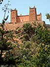 El Kasbah Ain Asserdoun Beni Mellal
 -
-
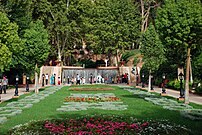
 Sultan Moulay Slimane University


References
- ^ "POPULATION LÉGALE DES RÉGIONS, PROVINCES, PRÉFECTURES, MUNICIPALITÉS, ARRONDISSEMENTS ET COMMUNES DU ROYAUME D'APRÈS LES RÉSULTATS DU RGPH 2014" (in Arabic and French). High Commission for Planning, Morocco. 8 April 2015. Retrieved 29 September 2017.
- ^ ISBN 978-1-4422-6297-3.
- ^ ISBN 978-90-04-13974-9.
- ISBN 978-84-00-07766-2.
- ^ "Average Conditions tetoaun, Morocco". BBC Weather. Retrieved August 17, 2009.
External links
- Lexicorient Archived 2016-03-03 at the Wayback Machine
- Monographie de la Ville de Beni Mellal (in French)
Capital: Beni Mellal | ||
| Municipalities | ||
| Rural communes | ||
| International | |
|---|---|
| National | |