
Berezan Island
Native name: Березань | |
|---|---|
 Berezan Island as seen from a distance. | |
 Berezan | |
| Geography | |
| Location | Black Sea |
| Coordinates | 46°36′N 31°24.6′E / 46.600°N 31.4100°E |
| Total islands | 1 |
| Area | 0.24 km2 (0.093 sq mi) |
| Length | 0.9 km (0.56 mi) |
| Width | 0.4 km (0.25 mi) |
| Administration | |
| Region | Mykolaiv Oblast |
| District | Mykolaiv Raion |
| Administered by | Olvia Preserve |
| Demographics | |
| Population | uninhabited (2001) |
| Additional information | |
 | |
Berezan (
History
Berezan was home to one of the earliest
In the Middle Ages, the island was of high military importance because it commanded the mouth of the Dnieper. During the period of
.svg)
The only
The control of the estuary (known in East Slavic sources as Beloberezhye, or White Shores) was disputed between Kievan Rus and
During the 14th and 15th centuries, when the entire Bug-Dniester interfluve was part of the Grand Duchy of Lithuania, there is little information about the island, and already at the turn of the 15th and 16th centuries the island was ruled by the Crimean Khanate, but was not inhabited. At the same time, the Zaporozhian Cossacks knew about the island and used it for anchorage of ships and rest during numerous sea voyages.[5]
Zaporozhian Cossacks revived Berezan as a fort during their campaigns against the
The site of the Greek colony and its necropolis have been periodically excavated since the 19th century; even though the site has suffered from erosion (and the tombs also from looting), the digs produced rich findings (archaic ceramics, inscriptions, etc.).
In March 1906, Pyotr Schmidt was executed on Berezan.
During World War II, the island became part of the Romanian Transnistria Governorate, along with all of the raion and city of Ochakiv.
In 2013, archaeologists found an
In 2023, the Ukrainian government constructed an underground munitions supply depot on the island in response to the Russian invasion amid concerns of bombing by the Russian air force.
Gallery
-
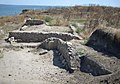 Archaeological excavations of Borysthenida on the island
 -
 Abandoned lighthouses
 -
 Obelisk to commemorate Lieutenant Schmidt
 -
 Flying over Berezan Island in a Cessna 150L


Notes
- ^ "Berezan Island". ochakov.glo (in Russian). Archived from the original on 8 April 2022.
- Eusebius states in his Chronikoi kanones that the colony was founded in 647–646 BC, by settlers from Miletus.
- ^ Treister, Michail J.; Vinogradov, Yuri G. "Archaeology on the Northern Coast of the Black Sea", American Journal of Archaeology, Vol. 97, No. 3. (1993), p. 538.
- ^ Entry X UaFv1914;47 in Rundata 2.0
- ISBN 966-7588-11-4. Retrieved 4 July 2021.
- ^ "На юге страны впервые нашли древний славянский крест" [An ancient Slavic cross was first found in the south of the country]. kp.ua (in Russian). 27 November 2013. Retrieved 21 December 2022.
Further reading
- Krÿzhitskii, Sergei D. "On the Types of Houses on the Island of Berezan", Ancient Civilizations from Scythia to Siberia, Vol. 11, Issue 3/4. (2005), pp. 181–197.
- Noonan, Thomas S."The Grain Trade of the Northern Black Sea in Antiquity", American Journal of Philology, Vol. 94, No. 3. (1973), pp. 231–242.
- Solovyov, Sergei L. Ancient Berezan: The Architecture, History and Culture of the First Greek Colony in the Northern Black Sea (Colloquia Pontica; 4). Leiden: Brill Academic Publishers, 1999 (hardcover, ISBN 90-04-11569-2).
- Reviewed by Balbina Baebler in the Bryn Mawr Classical Review, 2000.06.01.
- Reviewed by Sara Owen in The Journal of Hellenic Studies, Vol. 121. (2001), pp. 216–217.
- Solovyov, Sergey L. "Berezan Island: The Main Features for Archaeology", Bilkent University. The Department of Archaeology & History of Art Newsletter, No. 3. (2004), pp. 17–19.
- Solovyov, Sergei L. "Monetary Circulation and the Political History of Archaic Borysthenes", Ancient Civilizations from Scythia to Siberia, Vol. 12, Issue 1/2. (2006), pp. 63–75.
See also
- Khortytsia Island
- Snake Island
| International | |
|---|---|
| National | |
| Other | |