
Berinag
Berinag | |
|---|---|
UTC+5:30 (IST) | |
| Vehicle registration | UK |
| Website | uk |
Berinag is a hill station, located 124 km from Pithoragarh city in the Pithoragarh district, which is the easternmost Himalayan district in the state of Uttarakhand, India. It is one of the six Administrative Subdivisions (tehsil) of Pithoragarh district.[1] National Highway 309A passes through Berinag. Closest prominent villages include Garawon, Dhanoli, Bana, Bhattigaon, Banoli, Quarali, Tripuradevi and Sangarh.
Berinag gets its name from the Berinag Temple
Geography

Berinag is located at 29°48′N 80°04′E / 29.80°N 80.07°E.
Culture
Berinag is Culturally Rich region where various folk songs and dances are performed during auspicious occasions like marriage and festivals. Chacheri,
Transport
- Nearest airport is Naini Saini Airport, Pithoragarh : 112 km. Distance from Pantnagar Airport(PGH): 210 km.
- Nearest railway station is Kathgodam : 178 km.
- Berinag is well connected by road with Almora-96 km, Nainital-160 km, Haldwani-200 km, Bageshwar-62 km, Pithoragarh-85 km
See also
References
- ^ "Tehsils in Pithoragarh District, Uttarakhand". www.census2011.co.in. Retrieved 3 October 2016.
- ^ "Pithoragarh District Gazetteer" (PDF). Archived from the original (PDF) on 1 August 2014. Retrieved 10 March 2018.
- ^ Falling Rain Genomics, Inc - Berinag
Image Gallery
-
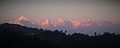 The Panchchuli as seen from Berinag, 2015
 -
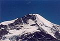 a Himalayan peak
 -
 The Panchchuli as seen from Berinag, 2016

