
Bhuj
Bhuj | |
|---|---|
2011 Census of India[1] |
Bhuj (
Etymology
According to legend, Kutch (Kachchh) was ruled by the Nāga chieftains in the past. Sagai, a queen of Sheshapattana, who was married to King Bheria Kumar, rose up against Bhujanga, the last chieftain of Naga. After the battle, Bheria was defeated and Queen Sagai committed sati. The hill where they lived later came to be known as Bhujia Hill and the town at the foothill as Bhuj. Bhujang was later worshiped by the people as snake god, Bhujanga, and a temple was constructed to revere him.[2]
History

Bhuj was founded by Rao Hamir in 1510 and was made the capital of
Bhuj has been attacked six times. In two instances, the defense was successful and in four other instances, the defense failed. In 1728, an attack by Sarbuland Khan, Mughal Viceroy of Gujarat, was repulsed by Rao Deshalji I, and, in 1765 Mian Ghulam Shah Kalhoro was, by a timely display of the strength of the fortifications, induced to withdraw. During the civil troubles of the reign of the Rao Rayadhan III, Bhuj was thrice taken, by Meghji Seth in 1786, by Hansraj in 1801, and by Fateh Muhammad in 1808. On 26 March 1819, the hill fort of Bhujia was captured by a British detachment under Sir William Keir.[4]
In 1818, Bhuj had a population of 20,000 people. The earthquake on 16 June 1819 destroyed nearly 7000 houses with a loss of an estimated 1140 human lives. About one-third of the buildings that escaped ruin were heavily damaged, and the north face of the town wall was leveled with the ground.
The British garrison at Bhuj peaked in 1826 with nearly 1400 British troops (685 infantry, 543 dragoons, 90 foot artillery and 74 horse artillery)[5] supported by over 5000 Indian soldiers. Amongst the highest profile British figures during this time was Alexander Burnes who was based here between 1826 and 1829.
In 1837, Bhuj is said to have had a population of 30,000, including 6,000 Muslims.[4]
After independence of India in 1947,
On 21 July 1956[6] as well as on 26 January 2001, the city suffered great losses of life and property due to earthquakes. Many parts of Bhuj were demolished due to the extensive damage, whilst others were repaired. There has been great progress in rebuilding the City since the 2001 earthquake, with considerable improvements to roads, transportation, and infrastructure.
Bhuj is home to one of the first
Geography
Bhuj has an average elevation of 110 metres (360 feet). On the eastern side of the city is a hill known as Bhujia Hill, on which there is a Bhujia Fort, that separates Bhuj city and Madhapar town ( considered one of the richest villages in Asia ). It has two lakes namely Hamirsar and Deshadsar (દેેેશળસર).

Climate
Bhuj has a borderline
Apart from the cool mornings of the "winter" season from December to February, temperatures are very warm to sweltering throughout the year, which further reduces the effectiveness of the erratic monsoonal rainfall. During the "hot" season from mid-March to mid-June, temperatures of 40 °C or 104 °F are frequent, whilst during the monsoon season they exceed 34 °C or 93.2 °F with high humidity except during rainy spells accompanied by cooler temperatures but oppressive humidity.
| Climate data for Bhuj (Bhuj Airport) 1981–2010, extremes 1963–2012 | |||||||||||||
|---|---|---|---|---|---|---|---|---|---|---|---|---|---|
| Month | Jan | Feb | Mar | Apr | May | Jun | Jul | Aug | Sep | Oct | Nov | Dec | Year |
| Record high °C (°F) | 37.0 (98.6) |
40.3 (104.5) |
43.9 (111.0) |
45.6 (114.1) |
47.8 (118.0) |
47.0 (116.6) |
41.3 (106.3) |
41.2 (106.2) |
42.8 (109.0) |
44.0 (111.2) |
39.7 (103.5) |
35.4 (95.7) |
47.8 (118.0) |
| Mean daily maximum °C (°F) | 27.4 (81.3) |
30.4 (86.7) |
35.4 (95.7) |
38.9 (102.0) |
39.4 (102.9) |
37.6 (99.7) |
34.2 (93.6) |
32.7 (90.9) |
34.9 (94.8) |
36.9 (98.4) |
33.1 (91.6) |
28.7 (83.7) |
34.1 (93.4) |
| Mean daily minimum °C (°F) | 10.0 (50.0) |
12.8 (55.0) |
18.1 (64.6) |
22.3 (72.1) |
25.5 (77.9) |
27.2 (81.0) |
26.4 (79.5) |
25.3 (77.5) |
24.3 (75.7) |
21.7 (71.1) |
16.0 (60.8) |
11.2 (52.2) |
20.1 (68.2) |
| Record low °C (°F) | −0.2 (31.6) |
0.3 (32.5) |
5.5 (41.9) |
12.7 (54.9) |
16.6 (61.9) |
16.1 (61.0) |
19.4 (66.9) |
20.0 (68.0) |
17.8 (64.0) |
11.1 (52.0) |
6.0 (42.8) |
0.6 (33.1) |
−0.2 (31.6) |
| Average rainfall mm (inches) | 1.3 (0.05) |
0.3 (0.01) |
1.1 (0.04) |
0.2 (0.01) |
1.5 (0.06) |
35.6 (1.40) |
130.9 (5.15) |
99.7 (3.93) |
48.6 (1.91) |
2.3 (0.09) |
1.8 (0.07) |
0.2 (0.01) |
323.3 (12.73) |
| Average rainy days | 0.2 | 0.0 | 0.2 | 0.1 | 0.3 | 1.8 | 5.0 | 3.8 | 2.2 | 0.4 | 0.2 | 0.1 | 14.3 |
| Average relative humidity (%) (at 17:30 IST )
|
32 | 29 | 29 | 29 | 39 | 51 | 64 | 66 | 54 | 33 | 31 | 33 | 41 |
| Source: India Meteorological Department[10][11][12][13] | |||||||||||||
Places of interest
This section needs expansion. You can help by adding to it. (April 2016) |

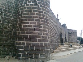
- The Fort: The old city was surrounded by a fort wall with five major gates (Mahadev, Patvadi, Sarpat, Bhid and Vaniyavad) and one small gate known as Chhathi Bari (sixth window). The fort wall is 35 feet high and four feet thick, and during its use was armed with fifty-one guns.[4] Much of the fort wall has either fallen down or been demolished, due to the damage sustained in the 2001 earthquake and the city's redevelopment.
- Hamirsar Lake
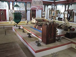
- Kutch Museum
- Prag Mahal
- Aina Mahal
- Sharadbaug Palace
- Chhatardi
- Ramkund
- Mohammad Pannah Masjid
- Bharatiya Sanskriti Darshan Museum
- Swaminarayan temple
- Bhujia Fort and Smritivan on Bhujia Hill
- Regional Science Centre
- Hill Garden
- Trimandir
- Tapkeshwari Temple
- Vande Mataram Memorial at village Bhujodi near Bhuj
- Living and Learning Design Centre at Bhuj - Bhachau Hwy Opp. Anchor Company, Ajarakhpur, Bhuj
- Smritivan Earthquake Memorial and Museum
-

-
-
 Sharadbaugh Palace
 -

-
 Ramkund
 -
 Swaminarayan temple
 -
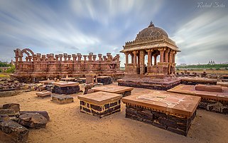 Chhatedi of Bhuj
 -

-
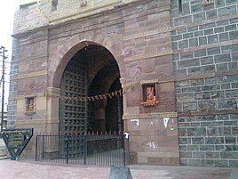 Mahadev Gate near Hamirsar Lake
 -
 Darbargadh Fort
 -
 Bhujia Fort and Smritivan on Bhujia Hill
 -
 Tapakeshwari Devi Temple near Bhuj
 -
 Hill Garden
 -
 The Vande Mataram Memorial is located at Village - Bhujodi near Bhuj


Demographics
In 2011 the population of Bhuj was 213,514, which consisted of 111,146 males and 102,368 females.[1] A 2003 source reported that 24% of Bhuj's population was Muslim.[14]
The slums of Bhuj are inhabited primarily by Muslims, Dalits and other minorities.[15][16] For example, in the slums of Western Bhuj, an estimated 80% of the population is Muslim.[17]
Culture

Bhuj is a famous destination within India for observing the historic craftsmanship of the Kutch region, including the textile crafts of bandhni (tie-dye), embroidery, Rogan art[18] and leatherwork. Artists of nearby villages bring their artwork for sale in 'Bhuj Haat', which is situated near Jubilee Ground. Locals often visit Hamirsar Lake for relaxation in natural surroundings.
Bhuj is also famous for its regional cuisine, especially Pakvans, chikki, Kutchhi Dabeli, (a vegetarian burger made with mashed potato, cooked with masala curry and chutneys), and regional Gujarati sweets.
Media and communications
State-owned All India Radio has a local station in Bhuj which transmits various programmes. Local TV channels and newspapers are the most popular media.
Education


Krantiguru Shyamji Krishna Verma Kachchh University is located in Bhuj. The university has 41 colleges affiliated, nineteen of which are in Bhuj. The university grants degrees in arts, science, commerce, law education, management, pharmacy, social welfare, medicine and engineering.[19]
Little Steps Montessori School is the first Montessori School in Kutch established in the year 2000 by the royal family of Tera-Kutch.
Primary and secondary
Matruchhaya Kanya Vidyalay Little Steps Montessori School Bhuj
- St. Xavier's High School, Bhuj
- Alfred High School
- Army Public School
- Sheth V.D. High School
- Indira Bai Girls High School
- Hope Foundation School near Ashapura Nagar
- Shree Swaminarayan Vidhyalaya
- Shishukunj International School
- White House Public School
- Matrushree R.D. Varsani high school
- Kendriya Vidyalaya No.1, Airforce Station Bhuj
- Kendriya Vidyalaya No.2, Army Cantt. Bhuj
- Bhuj English School
- Kiddy's Campus Nursery and Playhouse.
- Shree Kutchi Leva Patel Kanya Vidhyamandir.
- Chanakya Academy
Higher education
- Gujarat Adani Institute of Medical Science Archived 31 March 2023 at the Wayback Machine
Government Engineering College, Bhuj
- Government Polytechnic
- Shri R. R. Lalan College
- Sheth D. L. Law College
- Industrial Training Institute
- J B Thacker Commerce College
- MEWS College of Management & IT
- Sanskar Institute of Management & IT
Radio Station & Television
Bhuj has its own Radio Station with Studio. Prasar Bharati under Information and Broadcasting Ministry is operating Radio Studio. MW is available on 1314 kHz and FM is available on 103.7 MHz. There is also terrestrial DD channel available. DD National and DD Girnar available.
Transportation


Bhuj is connected to
Trains
| Train no. | Train Name | Runs From | Destination | Departure Days | Arrival Days |
|---|---|---|---|---|---|
| 11091-11092 | Bhuj-Pune express | Bhuj | Pune | Wednesday | Tuesday |
| 14312-14311 via Ahmedabad & 14322-14321 via Bhildi | Ala Hazrat Express
|
Bhuj | Bareilly | Tuesday, Thursday & Sunday for 14312. Monday, Wednesday, Friday & Saturday for 14322 | Friday, Saturday, Monday for 14311. Tuesday, Wednesday, Thursday & Sunday for 14321 |
| 22829-22830 | Shalimar - Bhuj Weekly SF Express
|
Bhuj | Shalimar
|
Tuesday | Monday |
| 22904-22903 | Bandra Terminus Bhuj AC Superfast Express
|
Bhuj | Bandra | Monday, Thursday, Saturday | Thursday, Saturday, Monday |
| 12960-12959 | Bhuj Dadar Superfast Express
|
Bhuj | Dadar | Monday, Thursday | Wednesday, Saturday |
| 19132-19131 | Kutch Express | Bhuj | Bandra | Daily | Daily |
| 19116-19115 | Shayajinagari Express | Bhuj | Dadar | Daily | Daily |
References
- ^ a b "Census of India". The Registrar General & Census Commissioner, India, New Delhi, Ministry of Home Affairs, Government of India. 26 June 2007. Retrieved 3 September 2015.
- ISBN 978-81-250-1383-9.
- ^ "History of Bhuj". Bhuj Online. Retrieved 31 October 2018.
- ^ a b c d Gazetteer of the Bombay Presidency: Cutch, Palanpur, and Mahi Kantha. Printed at the Government Central Press. 1880. pp. 215–216.
- ^ Sikunder Burnes, by Craig Murray, p36
- ^ "Quake rocks Kutch". The Hindu. 24 July 1956. Archived from the original on 24 August 2011. Retrieved 16 December 2013.
- ^ "Swaminarayan.faith - Home of Shree Swaminarayan Bhagwan".
- ^ Van Etten, Eddie J.B.; 'Inter-annual Rainfall Variability of Arid Australia: greater than elsewhere?'; Australian Geographer; 40 (2009), pp. 109-120
- ^ Dewar, Robert E. and Wallis, James R; 'Geographical patterning of interannual rainfall variability in the tropics and near tropics: An L-moments approach'; in Journal of Climate, 12; pp. 3457-3466
- ^ "Station: Bhuj (Rudramata)(A) Climatological Table 1981–2010" (PDF). Climatological Normals 1981–2010. India Meteorological Department. January 2015. pp. 143–144. Archived from the original (PDF) on 5 February 2020. Retrieved 28 September 2020.
- ^ "Extremes of Temperature & Rainfall for Indian Stations (Up to 2012)" (PDF). India Meteorological Department. December 2016. p. M50. Archived from the original (PDF) on 5 February 2020. Retrieved 28 September 2020.
- ^ "Bhuj Climatological Table Period: 1981–2010". India Meteorological Department. Archived from the original on 14 April 2015. Retrieved 10 April 2015.
- ^ "42634: Bhuj-Rudramata (India)". ogimet.com. OGIMET. 15 February 2023. Retrieved 16 February 2023.
- ISBN 9788186041154.)
{{cite book}}: CS1 maint: multiple names: authors list (link - ^ Ashish Kothari and Shrishtee Bajpai (9 June 2020). "Towards urban direct democracy in Bhuj, India".
- ^ Damayantee Dhar (18 September 2018). "Life of Muslims in Bhuj -- A Saga of Political Alienation And Discrimination".
- ^ Miwa Kanetani (2006). "Communities Fragmented in Reconstruction after the Gujarat Earthquake of 2001". Journal of the Japanese Association for South Asian Studies: 62.
- ^ Kansara, Ashish (19 August 2023). "Ancient intellectual Indian rogan art by Ashish Kansara". Kansara Rogan Art. Retrieved 22 December 2023.
- ^ "ક્રાંતિગુરુ શ્યામજી કૃષ્ણ વર્મા કચ્છ યુનિવર્સિટી". Kskvku.digitaluniversity.ac. Archived from the original on 5 September 2012. Retrieved 5 August 2012.
- This article incorporates Public Domain text from Gazetteer of the Bombay Presidency: Cutch, Palanpur, and Mahi Kantha. Printed at the Government Central Press. 1880. p. 216.
External links
- Kachchh University
- Bhuj Bole Chhe - Website maintained by the citizens of Bhuj about their city Archived 19 February 2020 at the Wayback Machine
- Official Facebook page for Bhuj
- Facebook page of Bhuj Bole Chhe - Voice of Bhuj Citizens
- Anando restaurant - Bhuj
| Topics |
|  |
|---|---|---|
| Regions of Gujarat | ||
| Districts | ||
| Major cities | ||
| Ecoregions |
| |
| Economy |
| |
| International | |
|---|---|
| National | |
| Geographic | |