
Big Shoals State Park
| Big Shoals State Park | |
|---|---|
 | |
  | |
| Location | Hamilton County, Florida, USA |
| Nearest city | White Springs, Florida |
| Coordinates | 30°20′21″N 82°40′59″W / 30.33917°N 82.68306°W |
| Governing body | Florida Department of Environmental Protection |
Big Shoals State Park in
Florida State Park. It is approximately one mile (1.6 km) east of White Springs, off US 41. The park is situated on the Suwannee River and features Limestone bluffs as well as the biggest whitewater rapids in all of Florida. The park also features more than 28 miles (45 km) of hiking and nature trails, and freshwater fishing.[2]
-
 Whitewater Rapids at Big Shoals
 -

-
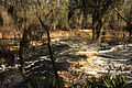
 Suwanee river
 -
 Camping area
 -
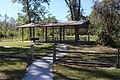 Little Shoals Picnic shelter
 -
 Tree line
 -
 Long Branch trail


See also
- List of Florida state parks
- List of Florida state forests
References
- ^ Big Shoals State Park Florida State Park
- ^ "Bob McNally's Outdoors Outlook". jacksonville.com. Retrieved April 21, 2017.
External links
- Big Shoals State Park at Florida State Parks
- Big Shoals State Park at State Parks
- Big Shoals State Park at Wildernet