
Old Blenheim Bridge
Old Blenheim Bridge | |
|---|---|
 HAER photo in 2004 | |
| Coordinates | 42°28′23″N 74°26′28″W / 42.473°N 74.441°W |
| Carried | Vehicles (1855–1936) Pedestrians (1936–2011) |
| Crossed | Schoharie Creek |
| Locale | North Blenheim, NY |
| Characteristics | |
| Design | double-barreled long truss with center arch covered bridge[1][2] |
| Total length | 232 ft 0 in (70.7 m)[3] |
| Width | 26 ft 3 in (8.0 m)[3] |
| Height | 30 feet (9.1 m)[3] |
| Longest span | 210 feet (64 m)[3] |
| History | |
| Designer | Nichols M. Powers[4][3] |
| Opened | 1855[1] |
| Collapsed | August 28, 2011 |
Old Blenheim Bridge | |
Formerly listed on the U.S. National Register of Historic Places | |
Schoharie County | |
| Built | 1854–1855 |
| Architect | Nichols Montgomery Powers |
| NRHP reference No. | 66000570 |
| Significant dates | |
| Added to NRHP | October 15, 1966[5] |
| Designated NHL | January 29, 1964[6] |
| Removed from NRHP | July 21, 2015 |
| Delisted NHL | July 21, 2015 |
| Location | |
 | |
Old Blenheim Bridge was a wooden
History
Nicholas Montgomery Powers
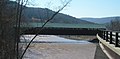
On August 28, 2011, record flooding along the Schoharie Creek, due to
Longest bridge
Many sources simply claimed the Old Blenheim Bridge was the longest surviving single-span covered bridge, without getting into span length vs. total length. There are also sources that claim the
A report by the
Historically, the longest single-span covered bridge on record was Pennsylvania's
Destruction
The bridge was destroyed on August 28, 2011, as a result of flooding from
A witness saw its roof deposited onto a modern bridge just downstream, when the bridge was swept away at about 1 p.m. Over subsequent months, the Schoharie County Highway Department collected pieces of the bridge up to about 30 miles (48 km) downstream.[10]
On July 21, 2015, National Historic Landmark designation for the bridge was withdrawn and the property was delisted from the National Register of Historic Places.[11]
Replacement
A replacement for the bridge was built in 2017, exactly reproducing the design of the original. It was built to stand 15 feet (4.6 m) higher to avoid future floods.
Gallery
-
 Oblique view as photographed from up the hill on the eastern shore
 -
 The span of the Old Blenheim Bridge as photographed 11 March 2008.
 -
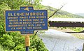 Old Blenheim Bridge NYS Education Dept. Historical Marker (with bridge in background) as photographed 29 May 2009
 -
 Registered National Historic Landmark Plaque


See also
- List of bridges documented by the Historic American Engineering Record in New York
- Hartland Bridge – longest covered bridge (multiple spans) in the world; Hartland, New Brunswick
- Smolen–Gulf Bridge – longest covered bridge (multiple spans) in the United States, Ashtabula County, Ohio
- Bartonsville Covered Bridge - a shorter covered bridge in Rockingham, Vermont, also destroyed by Tropical Storm Irene, replaced in 2013; it still carries traffic
References
- ^ ISBN 0-471-14385-5.
- ^ "Blenheim Bridge". Covered Bridges of the Northeast USA.
- ^ a b c d e f g h Bennett, Lola (2002). "Blenheim Bridge" (PDF). Historic American Engineering Record. Washington, D.C.: Library of Congress. p. 1. Retrieved March 1, 2014.
- ^ ISSN 1087-9889. Retrieved May 30, 2010.
In 1837, the people of Pittsford, Vermont, contracted 19-year-old Nichols Powers to build a bridge over Otter Creek.
- ^ "National Register Information System". National Register of Historic Places. National Park Service. January 23, 2007.
- ^ a b "Blenheim Covered Bridge". National Historic Landmark summary listing. National Park Service. September 18, 2007.
- ^ Dillon, James (1974). "National Register of Historic Places Registration: Old Blenheim Bridge" (pdf). National Park Service.
{{cite journal}}: Cite journal requires|journal=(help) and Accompanying Photos, from 1974 (642 KB) - ^ "Old Blenheim Bridge Historical Marker". The Historical Marker Database. Retrieved March 6, 2021.
- ^ Eckholm, Erik (August 31, 2011). "Covered Bridges, Beloved Remnants of Another Era, Were Casualties, Too". The New York Times. Retrieved September 1, 2011.
- Albany Times Union. Retrieved February 6, 2022.
- ^ "Withdrawn Designations: Old Blenheim Bridge". National Park Service.
- ^ Reischel, Julia (September 18, 2015). "The Blenheim Covered Bridge will rise again". Watershed Post. Retrieved May 19, 2017.
- ^ Mitsopoulos, Patricia (June 29, 2016). "Blenheim Bridge Design Gets Approval". The Mountain Eagle. Columbia-Greene Media. Retrieved May 19, 2017.
- ^ Fitzsimmons, Daniel (June 30, 2016). "New Blenheim Bridge nearing approval". The Daily Gazette. Schenectady, NY. Retrieved May 19, 2017.
- ^ Old Blenheim with Old Blenheim Bridge Replacement
- ^ "Operation Bridge Rescue — NOVA | PBS". www.pbs.org. Retrieved October 4, 2018.
External links
 Media related to Old Blenheim Bridge at Wikimedia Commons
- Photos of Blenheim Covered Bridge by Douglas Kerr
- Photos of Blenheim Covered Bridge by Charles Peifer
- Blenheim Bridge, at New York State Covered Bridge Society
- Historic American Buildings Survey (HABS) No. NY-359, "Blenheim Covered Bridge, Spanning Schoharie River, North Blenheim, Schoharie County, NY", 2 photos, 4 measured drawings, 6 data pages, supplemental material
- Historic American Engineering Record (HAER) No. NY-331, "Blenheim Bridge, Spanning Schoharie Creek, River Road (now bypassed), North Blenheim, Schoharie County, NY", 13 photos, 12 data pages, 1 photo caption page
- Old Blenheim Bridge at Structurae
