
Bogotá Fault
| Bogotá Fault | ||
|---|---|---|
| Falla de Bogotá | ||
Age Pleistocene (<1.6 Ma) | | |
| Orogeny | Andean | |
The Bogotá Fault (
The fault stretches from the
.Pulsations of the fault movement in the early Quaternary have produced the alluvial fans of the Tunjuelo Formation. In part, the fault is covered by Late Pleistocene deposits of the Sabana Formation showing a pre-Holocene activity with no known historical seismicity or registered damages. The present slip rate of the Bogotá Fault is established at 0.01 to 0.1 millimetres (0.00039 to 0.00394 in) per year.
Etymology
The fault is named after Bogotá, Cundinamarca by Thomas Clements, who performed the first study on the fault in 1940.[3]
Description

The Bogotá Fault extends across the
The tectonic regime of the
The fault mainly cuts Cretaceous and Tertiary sedimentary rocks and, to some extent, early Quaternary deposits. The fault produces strong slope changes between different geologic units on both sides of the fault plane and displays degraded fault scarps,[1] especially the well-known Monserrate, the location where the fault was first studied.[13] The brecciated zone of the fault has a width between 10 and 20 metres (33 and 66 ft). The brecciated area of the fault is well exposed along the road from Bogotá to La Calera, north of Calle 85 in the capital. At the entrance to the cable car going up to Monserrate, the fault shows reverse and normal offset faults and produced fractures in the shales (Plaeners Formation) of the Guadalupe Group.[2] The alluvial fans of the Tunjuelo Formation were produced by the seismic pulses of the Bogotá Fault.[14]
Activity
The Bogotá Fault was first analyzed by Thomas Clements in 1940,[3] and he concluded the fault was still active.[2] However, later studies have shown the fault does not displace younger Quaternary deposits and is hence determined being inactive. No known historical earthquakes have been produced by the fault,[15] and recent seismic activity has not been registered.[16] The Bogotá Fault crosscuts the Rosales tunnel where no damages have been noted.[17] A slip rate of 0.01 to 0.1 millimetres (0.00039 to 0.00394 in) per year is calculated from displaced geomorphologic Quaternary features.[18]
Gallery
-
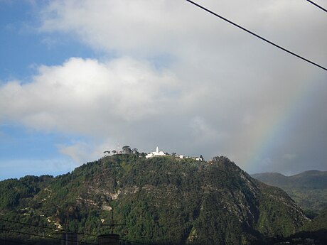 Monserrate Hill was formed by the Bogotá Fault
 -
 Fault scarps at Cerro Aguanoso
 -
 Intense fracturing in the Guadalupe Group


.jpg)
See also
- List of earthquakes in Colombia
- Bucaramanga-Santa Marta Fault
- Eastern Frontal Fault System
- Usme Fault
- Vianí Fault
References
- ^ a b Paris et al., 2000a, p.47
- ^ a b c Lobo-Guerrero Uscátegui, 2005, p.5
- ^ a b Clements, 1940
- ^ Lobo-Guerrero Uscátegui, 2005, p.4
- ^ Lobo-Guerrero Uscátegui, 2005, p.1
- ^ Velandia & De Bermoudes, 2002, p.42
- ^ Paris et al., 2000b
- ^ Geological Map Bogotá, 1997
- ^ Torres et al., 2005, p.131
- ^ Lobo-Guerrero Uscátegui, 2005, pp.13–14
- ^ Lobo-Guerrero Uscátegui, 1992, p.8
- ^ Montoya & Reyes, 2005, p.72
- ^ Lobo-Guerrero Uscátegui, 2005, p.2
- ^ Lobo-Guerrero Uscátegui, 1996, p.13
- ^ Espinosa Baquero, 2004
- ^ Acosta & Garay, 2002, p.93
- ^ Lobo-Guerrero Uscátegui, 2005, p.6
- ^ Paris et al., 2000a, p.48
Bibliography
- Acosta, Jorge E., and Carlos E. Ulloa. 2002. Mapa geológico del Departamento de Cundinamarca 1:250,000 - Memoria Explicativa, 1-108. INGEOMINAS.
- Clements, Thomas. 1940. The Bogota Fault, Colombia, South America. Journal of Geology48. 660–669. Accessed 2018-05-23.
- Espinosa Baquero, Armando. 2004. Historia Sísmica de Bogotá, 1–10. Sociedad Geográfica de Colombia. Accessed 2018-05-23.
- Guerrero Uscátegui, Alberto Lobo. 2005. La Falla de Bogotá en Cundinamarca, 1–17. X Congreso Colombiano de Geología. Accessed 2018-05-23.
- Guerrero Uscátegui, Alberto Lobo. 1996. Estratigrafía del material no-consolidado en el subsuelo del nororiente de Santafé de Bogotá (Colombia) con algunas notas sobre historia geológica, 1–23. VIl Congreso Colombiano de Geología.
- Guerrero Uscátegui, Alberto Lobo. 1992. Geología e Hidrogeología de Santafé de Bogotá y su Sabana, 1–20. Sociedad Colombiana de Ingenieros.
- Montoya Arenas, Diana María, and Germán Alfonso Reyes Torres. 2005. Geología de la Sabana de Bogotá, 1–104. INGEOMINAS.
- Paris, Gabriel; Michael N. Machette; Richard L. Dart, and Kathleen M. Haller. 2000a. Map and Database of Quaternary Faults and Folds in Colombia and its Offshore Regions, 1–66. USGS. Accessed 2018-05-23.
- Torres, Vladimir; Jeff Vandenberghe, and Henry Hooghiemstra. 2005. An environmental reconstruction of the sediment infill of the Bogotá basin (Colombia) during the last 3 million years from abiotic and biotic proxies. Palaeogeography, Palaeoclimatology, Palaeoecology 226. 127–148. .
- Velandia Patiño, F.A., and O. De Bermoudes. 2002. Fallas longitudinales y transversales de la Sabana de Bogotá, Colombia. Boletín de Geología 24. 37–48. .
Maps
- Acosta, Jorge; Carlos Ulloa; Pilar García, and Orlando Solano. 1999. Mapa Geológico de Cundinamarca, 1. INGEOMINAS. Accessed 2018-05-23.
- Buitrago, José Alberto; Roberto Terraza M., and Fernando INGEOMINAS. Accessed 2018-05-23.
- Gómez, J.; N.E. Montes; Á. Nivia, and H. Diederix. 2015. Plancha 5-09 del Atlas Geológico de Colombia 2015 – escala 1:500,000, 1. Servicio Geológico Colombiano. Accessed 2018-05-23.
- Paris, Gabriel; Michael N. Machette; Richard L. Dart, and Kathleen M. Haller. 2000b. Map of Quaternary Faults and Folds of Colombia and Its Offshore Regions, 1. USGS. Accessed 2018-05-23.
- Various, Authors. 1997. Mapa geológico de Santa Fe de Bogotá – Geological Map Bogotá – escala 1:50,000, 1. INGEOMINAS. Accessed 2018-05-23.
| Tectonic plates |    | ||||||||||
|---|---|---|---|---|---|---|---|---|---|---|---|
| Terranes | |||||||||||
| Terrane-bounding fault systems |
| ||||||||||
| Intraterrane faults |
| ||||||||||
| Major earthquakes | |||||||||||
| Orogenies | |||||||||||
| Other topics | |||||||||||
| Sources | Paris, Gabriel; Machette, Michael N.; Dart, Richard L.; Haller, Kathleen M. (2000). Map and Database of Quaternary Faults and Folds in Colombia and its Offshore Regions (PDF). USGS. pp. 1–66. Retrieved 2017-06-20.
Gómez Tapias, Jorge; Montes Ramírez, Nohora E.; Almanza Meléndez, María F.; Alcárcel Gutiérrez, Fernando A.; Madrid Montoya, César A.; Diederix, Hans (2015). Geological Map of Colombia. | ||||||||||