
Bolikhamsai province
Bolikhamsai province
ແຂວງ ບໍລິຄໍາໄຊ | |
|---|---|
UTC+7 (ICT) | |
| ISO 3166 code | LA-BL |
| HDI (2017) | medium · 4th |
Bolikhamsai (also Borikhamxay,
Bolikhamsai province covers an area of 14,863 square kilometres (5,739 sq mi).
History
The province faced invasions from the
In the 1890s, Christian missionaries of the Missions étrangères de Paris arrived on the Mekong River, a few miles from the mouth of the
The modern province was formed in 1986 from parts of the
Geography
Bolikhamsai province covers an area of 14,863 square kilometres (5,739 sq mi).[8] Bolikhamsai province borders Xiangkhouang province to the northwest, Vietnam to the east, Khammouane province to the south, and Thailand to the west. Notable settlements include Pakxan, Borikham, Lak Sao, Muang Bo, Ban Hatkham, Ban Thana, Ban Thasi, Ban Hai, Ban Don, Ban Soppanga, Ban Pak Ham, Ban Naxon, Ban Kengbit, Ban Pakha, Ban Phayat, Ban Sopchat, Ban Muangcham and Ban Nap. The province includes the Annamite Range, stretching east to Vietnam, while to the west are the Mekong River and Thailand.[3]
Bolikhamsai province has a rugged terrain, with large boulders and streams. Its
-
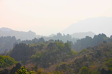 Karst rock formations
 -
 Tad Leuk, Phou Khao Khouay National Protected Area
 -
 Landscape, Lak Sao
 -
 Saola (Pseudoryx nghetinhensis)


.jpg)

Protected areas
At 4,270 square kilometres (1,650 sq mi),
Under the
Administrative divisions
The province is made up of the following districts:[2]
| Map | Code | Name | Lao script |
|---|---|---|---|

| |||
| 11–01 | Pakxan District | ເມືອງປາກຊັນ | |
| 11–02 | Thaphabat District
|
ເມືອງທ່າພະບາດ | |
| 11–03 | Pakkading District
|
ເມືອງປາກກະດິງ | |
| 11–04 | Borikhane District
|
ເມືອງບໍລິຄັນ | |
| 11–05 | Khamkeut District
|
ເມືອງຄຳເກີດ | |
| 11–06 | Viengthong District
|
ເມືອງວຽງທອງ | |
| 11–07 | Xaichamphon District
|
ເມືອງໄຊຈໍາພອນ |
Economy
Laos's largest hydroelectric project,
Landmarks
Wat Phabath and Wat Phonsanh temples are important pilgrimage centres between Vientiane and Pakxan. Wat Phabath is said to have a very large footprint of Buddha and numerous murals. The location provides vistas of the Mekong River.[2] Lak Sao, on the border, has the Nampao Checkpoint, crossing into Vietnam.
References
- ^ "Sub-national HDI - Area Database - Global Data Lab". hdi.globaldatalab.org. Retrieved 2018-09-13.[not specific enough to verify]
- ^ a b c d "Destination: Borikhamxay Province". Laos Tourism Organization. Archived from the original on 13 October 2013. Retrieved 1 December 2012.
- ^ a b Ray 2009, p. 321.
- ^ "Home". Regions. Official website of Laos Tourism. Archived from the original on 11 January 2013. Retrieved 7 January 2013.
- ^ Brow 1976, p. 48.
- ^ Sachs 1997, p. 18.
- ^ Marshall 2007, p. 253.
- ^ "Borikhamxay Province". Lao Tourism. Archived from the original on 13 October 2013. Retrieved 1 December 2012.
- ^ a b c d e The Lao National Tourism Administration. "Bolikhamxay Province". Ecotourism Laos. GMS Sustainable Tourism Development Project in Lao PDR. Archived from the original on 29 August 2012. Retrieved 1 December 2012.
- ^ "Lao PDR's Nakai Nam Theun National Park to join leading protected areas in Southeast Asia, nominated to IUCN's Green List". IUCN. 18 August 2020. Retrieved 2 February 2021.
- ^ a b c d "Improved management of the Nam Kading National Protected Area of Bolikhamxay Province, Lao PDR". CBD Protected Areas. Retrieved 30 November 2012.[not specific enough to verify]
- ^ a b Campbell, Roderick (June 2009). "Technical Report Non Timber Forest Product inventory and value in Bolikhamsai Province, Lao PDR" (pdf). Lao Agriculture Database. National Agriculture and Forestry Research Institute. Retrieved 30 November 2012.
- ^ "Bolikhamsai Province". Internet Bird Collection (IBC). Retrieved 29 November 2012.[not specific enough to verify]
- ISBN 978-1-4527-9182-1. Retrieved 6 December 2012.
Sources
- Brow, James (1976). Population, Land and Structural Change in Sri Lanka and Thailand. Brill Archive. ISBN 978-90-04-04529-3.
- Great Britain. Parliament. House of Commons (1958). Papers by command. HMSO. p. 98.
- Leo, Leonard. International Religious Freedom (2010): Annual Report to Congress. DIANE Publishing. ISBN 978-1-4379-4439-6.
- Marshall, Paul A. (28 December 2007). Religious freedom in the world. Rowman & Littlefield Publishers. ISBN 978-0-7425-6212-7.
- Ray, Nick (11 September 2009). Lonely Planet Vietnam Cambodia Laos & the Greater Mekong. Lonely Planet. pp. 321–. ISBN 978-1-74179-174-7.
- Sachs, Carolyn E. (1997). Women Working in the Environment: Resourceful Natures. Taylor & Francis. pp. 18–. ISBN 978-1-56032-629-8.
Places adjacent to Bolikhamsai province | ||||||||||||||||
|---|---|---|---|---|---|---|---|---|---|---|---|---|---|---|---|---|
| ||||||||||||||||