
Borsod-Abaúj-Zemplén County
Borsod-Abaúj-Zemplén County
Borsod-Abaúj-Zemplén vármegye | ||
|---|---|---|
  .JPG) Descending, from top: Hills near Boldogkőváralja, Sajó river near Sajónémeti, and Castle of Diósgyőr | ||
|
Region Northern Hungary | | |
| County seat | Miskolc | |
| Districts | ||
| Government | ||
| • President of the General Assembly | Dezső Török (Fidesz-KDNP) | |
| Area | ||
| • Total | 7,249.67 km2 (2,799.11 sq mi) | |
| • Rank | 2nd in Hungary | |
| Population (2018) | ||
| • Total | 648,216[1] | |
| • Rank | 2nd in Hungary | |
| GDP | ||
| • Total | HUF 1,672 billion €5.370 billion (2016) | |
| Postal code | 34xx–39xx | |
| Area code(s) | (+36) 46, 47, 48, 49 | |
| ISO 3166 code | HU-BZ | |
| Website | baz | |
Borsod-Abaúj-Zemplén (
Borsod-Abaúj-Zemplén is the second largest county of Hungary both by area (after
Origins and meanings of name
The county bears the name of three
- motte castle, and stood near modern-day Edelény.
- Abaúj is a shortened form of the name of its castle, Abaújvár. The Aba portion refers to the Aba clan which ruled the area in the Middle Ages, while új vár means 'new castle.' The castle stood near the village of Abaújvár.
- .
Note that besides these three castles, there were other castles in the old counties which became the modern Borsod-Abaúj-Zemplén, such as the well-known Füzérvár.
Coat of arms and flag

The county's coat of arms was created in 1991 from the coats of arms of the former counties now forming parts of Borsod-Abaúj-Zemplén. From left to right: Coat of arms of Abaúj-Torna county. – Coat of arms of Zemplén county. – Coat of arms of Borsod county. – Coat of arms of Gömör / Gömör-Kishont county[4] (with its red background color changed to the same blue as used in the coat of arms of Abaúj).
The flag is vertically divided into two equal sections (red and blue), with the coat of arms on it, and the county's name embroidered with gold thread under the coat of arms. Its ratio is 2:1. The use of both coat of arms and flag is regulated by the county council.[4]
Geography
Borsod-Abaúj-Zemplén is one of the most
Rivers
- Tisza, which forms a natural border between Borsod-Abaúj-Zemplén and Szabolcs-Szatmár-Bereg countries
- Sajó, a tributary to Tisza
- Bodrog, a tributary to Tisza
- Hernád, a tributary to Sajó
Highest points
- Istállós-kő, Bükk Mountains (959 m.)
- Nagy-Milic, Zemplén Mountains (894 m.)
History
Borsod-Abaúj-Zemplén county was created after
From the Conquest until the Turkish occupation (900s–1526)
The historical
At this time the area of Borsod also included the later county
. In the 12th century the former Abaúj comitatus was split into Abaúj, Heves and Sáros counties, while Torna was separated from Borsod. For the next hundreds of years the borders remained unchanged.About two-thirds of the areas of these counties were royal property, the others were ruled by clans, for example the Miskóc clan (after whom the city of Miskolc was named.) The area was inhabited mostly by castle serfs and foreign settlers (
By the 14th century most of the area was owned by
The differences between towns and villages became important during the Anjou age of Hungary. In Borsod and Abaúj the Free Royal Town of Kassa (today's Košice, Slovakia) and Miskolc emerged as the most important towns. The Castle of Diósgyőr had its prime under Louis the Great, it was one of the favourite residences of the royal family.
In the 16th century wine growing gained more importance. Today
From the Turkish occupation until the First World War (1526–1914)
After the
The region also had cultural importance. The
During the 18th century several towns bought their freedom from their
After the
Furthermore, a large population of Jews was established during this time period. The famous film mogul who created Paramount Pictures, Adolph Zukor, was born in Ricse, a town in this county.[5]
From 1914 to today
After World War I and the Treaty of Trianon Hungary had to give up its northern parts to Czechoslovakia. Abaúj-Torna had to give up 48% of its area, 72% of Zemplén became part of Czechoslovakia, only Borsod remained fully within Hungary. The neighboring county of Gömör-Kishont retained 7.5% of its area, and remaining parts were merged with Borsod. The county seats were Miskolc (Borsod-Gömör-Kishont), Szikszó (Abaúj-Torna) and Sátoraljaújhely (Zemplén).
Under the
During the Socialist era the region was developed into the centre of heavy industry. Whole new towns came into existence in place of small villages (Tiszaújváros, Kazincbarcika), the industrial character of existing cities became more important (Miskolc, Ózd.) Urbanization was rapid, workers from all over the country were arriving in these cities and towns, and the population of Miskolc reached its highest level in the 1980s (around 211.000.) The end of the Socialist era and the recession of the 1990s hit hard, the unemployment rate is one of the highest of the country, and the local governments try to get over the crisis by strengthening the touristic potential. This seems to be a good idea, since Borsod-Abaúj-Zemplén is a geographically diverse area with rich natural and cultural treasures.
Demographics
Religion in Borsod-Abaúj-Zemplén County (2011 census)
In 2015, it had a population of 667,594 and the population density was 92/km2.
| Year | County population[6] | Change |
|---|---|---|
| 1949 | 630,621 | n/a |
| 1960 | 15.01% | |
| 1970 | 7.09% | |
| 1980 | 4.21% | |
| 1990 | -5.87% | |
| 2001 | -2.30% | |
| 2011 | -7.81% | |
| 2015 | -2.79% | |
| 2018 | -2.99% |
Ethnicity
Besides the Hungarian majority, the main minorities are the Roma (approx. 58,000), Germans (2,500), Slovaks (2,000) and Rusyns (1,500).
Total population (2011 census): 686,266
Ethnic groups (2011 census):[7]
Identified themselves: 643,950 persons:
- Hungarians: 576,814 (89.57%)
- Romani: 58,246 (9.05%)
- Others and indefinable: 8,890 (1.38%)
Approx. 89,000 persons in Borsod-Abaúj-Zemplén County did not declare their ethnic group at the 2011 census.
Religion
Religious adherence in the county according to 2011 census:[8]
- Catholic – 282,904 (Roman Catholic – 248,033; Greek Catholic– 34,816);
- Reformed – 135,677;
- Evangelical – 3,483;
- other religions – 10,500;
- Non-religious – 83,033;
- Atheism – 5,821;
- Undeclared – 164,848.
Regional structure

| No. | English and Hungarian names |
Area (km2) |
Population (2011) |
Density (pop./km2) |
Seat | No. of municipalities |
| 1 | Cigánd District Cigándi járás |
389.99 | 16,042 | 41 | Cigánd | 15 |
| 2 | Edelény District Edelényi járás |
717.86 | 33,314 | 46 | Edelény | 45 |
| 3 | Encs District Encsi járás |
378.39 | 21,390 | 56 | Encs | 29 |
| 4 | Gönc District Gönci járás |
549.67 | 19,275 | 35 | Gönc | 32 |
| 5 | Kazincbarcika District Kazincbarcikai járás |
341.70 | 66,470 | 195 | Kazincbarcika | 22 |
| 6 | Mezőcsát District Mezőcsáti járás |
351.27 | 14,446 | 41 | Mezőcsát | 8 |
| 7 | Mezőkövesd District Mezőkövesdi járás |
723.87 | 42,434 | 59 | Mezőkövesd | 23 |
| 8 | Miskolc District Miskolci járás |
972.80 | 250,530 | 258 | Miskolc | 39 |
| 9 | Ózd District Ózdi járás |
385.57 | 54,285 | 141 | Ózd | 17 |
| 10 | Putnok District Putnoki járás |
391.25 | 19,290 | 49 | Putnok | 26 |
| 11 | Sárospatak District Sárospataki járás |
477.67 | 24,946 | 52 | Sárospatak | 16 |
| 12 | Sátoraljaújhely District Sátoraljaújhelyi járás |
321.38 | 23,058 | 72 | Sátoraljaújhely | 21 |
| 13 | Szerencs District Szerencsi járás |
432.07 | 38,106 | 88 | Szerencs | 16 |
| 14 | Szikszó District Szikszói járás |
309.25 | 17,507 | 57 | Szikszó | 24 |
| 15 | Tiszaújváros District Tiszaújvárosi járás |
248.87 | 31,842 | 128 | Tiszaújváros | 16 |
| 16 | Tokaj District Tokaji járás |
255.81 | 13,331 | 52 | Tokaj | 11 |
| Borsod-Abaúj-Zemplén County | 7,249.67 | 686,266 | 95 | Miskolc | 358 | |
|---|---|---|---|---|---|---|
Economy
Due to the emphasis on industrialization during the former
The county is the site of the Borsod Power Plant, one of the largest biomass power plants in Hungary.
Politics

County Assembly
The Borsod-Abaúj-Zemplén County Council, elected at the 2019 local government elections, is made up of 29 counselors,[9] with the following party composition:
| Party | Seats | Current County Assembly | ||||||||||||||||||
|---|---|---|---|---|---|---|---|---|---|---|---|---|---|---|---|---|---|---|---|---|
| Fidesz-KDNP | 18 | |||||||||||||||||||
| Opposition coalition[a] | 8 | |||||||||||||||||||
| Democratic Coalition | 3 | |||||||||||||||||||
Presidents of the County Assembly
| President[10] | Terms |
|---|---|
| Dezső Török (Fidesz-KDNP) | 2014– |
Members of the National Assembly
The following members elected of the National Assembly during the 2022 parliamentary election:[11]
Municipalities
Borsod-Abaúj-Zemplén County has 1
Borsod-Abaúj-Zemplén is the county of extremes: it is the home of the country's fourth largest city and second largest agglomeration, where one fourth of the county' population resides, on the other hand, the county is full of hamlets with population under 200. Borsod-Abaúj-Zemplén has 28 cities/towns (as of 2019) and over 300 villages. With a total of 358 cities, towns and villages this county has the most municipalities in Hungary. Approximately half of the population lives in cities/towns.
- City with county rights
(ordered by population, as of 2011 census)
- Miskolc (167,754) – county seat
- Towns
- Ózd (34,481)
- Kazincbarcika (29,010)
- Mezőkövesd (16,559)
- Tiszaújváros (16,500)
- Sátoraljaújhely (15,783)
- Sárospatak (12,991)
- Sajószentpéter (12,012)
- Edelény (9,986)
- Szerencs (9,198)
- Putnok (6,905)
- Felsőzsolca (6,613)
- Encs (6,344)
- Mezőcsát (5,980)
- Alsózsolca (5,766)
- Szikszó (5,631)
- Nyékládháza (5,023)
- Emőd (5,007)
- Tokaj (4,530)
- Szendrő (4,065)
- Mezőkeresztes (3,886)
- Borsodnádasd (3,169)
- Abaújszántó (3,147)
- Cigánd (2,963)
- Sajóbábony (2,887)
- Rudabánya (2,583)
- Gönc (2,059)
- Pálháza (1,061)
- Villages
- Abaújalpár
- Abaújkér
- Abaújlak
- Abaújszolnok
- Abaújvár
- Abod
- Aggtelek
- Alacska
- Alsóberecki
- Alsódobsza
- Alsógagy
- Alsóregmec
- Alsószuha
- Alsótelekes
- Alsóvadász
- Arka
- Arló

- Arnót
- Aszaló
- Ároktő
- Baktakék
- Balajt
- Baskó
- Bánhorváti
- Bánréve
- Becskeháza
- Bekecs
- Berente
- Beret
- Berzék
- Bodroghalom
- Bodrogkeresztúr
- Bodrogkisfalud
- Bodrogolaszi
- Bogács
- Boldogkőújfalu
- Boldogkőváralja
- Boldva
- Borsodbóta
- Borsodgeszt
- Borsodivánka
- Borsodszentgyörgy
- Borsodszirák
- Bódvalenke
- Bódvarákó
- Bódvaszilas
- Bózsva
- Bőcs
- Bükkaranyos
- Bükkábrány
- Bükkmogyorósd
- Bükkszentkereszt
- Bükkzsérc
- Büttös
- Csenyéte
- Cserépfalu
- Cserépváralja
- Csernely
- Csincse
- Csobaj
- Csobád
- Csokvaomány
- Damak
- Dámóc
- Debréte
- Detek
- Dédestapolcsány
- Domaháza
- Dövény
- Dubicsány
- Egerlövő
- Erdőbénye
- Erdőhorváti
- Égerszög
- Fancsal
- Farkaslyuk
- Fáj
- Felsőberecki
- Felsődobsza
- Felsőgagy
- Felsőkelecsény
- Felsőnyárád
- Felsőregmec
- Felsőtelekes
- Felsővadász
- Filkeháza
- Fony
- Forró
- Fulókércs
- Füzér
- Füzérkajata
- Füzérkomlós
- Füzérradvány
- Gadna
- Gagyapáti
- Gagybátor
- Gagyvendégi
- Galvács
- Garadna
- Gelej
- Gesztely
- Gibárt
- Girincs
- Golop
- Gömörszőlős
- Göncruszka
- Györgytarló
- Halmaj
- Hangács
- Hangony
- Harsány
- Háromhuta
- Hegymeg
- Hejce
- Hejőbába
- Hejőkeresztúr
- Hejőkürt
- Hejőpapi
- Hejőszalonta
- Hercegkút
- Hernádbűd
- Hernádcéce
- Hernádkak
- Hernádkércs
- Hernádnémeti
- Hernádpetri
- Hernádszentandrás
- Hernádszurdok
- Hernádvécse
- Hét
- Hidasnémeti
- Hidvégardó
- Hollóháza
- Homrogd
- Igrici
- Imola
- Ináncs
- Irota
- Izsófalva
- Jákfalva
- Járdánháza
- Jósvafő
- Karcsa
- Karos
- Kács
- Kánó
- Kány
- Kázsmárk
- Kelemér
- Kenézlő
- Keresztéte
- Kesznyéten
- Kéked
- Királd
- Kiscsécs
- Kisgyőr
- Kishuta
- Kiskinizs
- Kisrozvágy
- Kissikátor
- Kistokaj
- Komjáti
- Komlóska
- Kondó
- Korlát
- Kovácsvágás
- Köröm
- Krasznokvajda
- Kupa
- Kurityán
- Lak
- Lácacséke
- Ládbesenyő
- Legyesbénye
- Léh
- Lénárddaróc
- Litka
- Makkoshotyka
- Martonyi
- Mád
- Mályi
- Mályinka
- Megyaszó
- Meszes
- Mezőnagymihály
- Mezőnyárád
- Mezőzombor
- Méra
- Mikóháza
- Mogyoróska
- Monaj
- Monok
- Muhi
- Múcsony
- Nagybarca
- Nagycsécs
- Nagyhuta
- Nagykinizs
- Nagyrozvágy
- Nekézseny
- Nemesbikk
- Négyes
- Novajidrány
- Nyésta
- Nyíri
- Nyomár
- Olaszliszka
- Onga
- Ormosbánya
- Oszlár
- Ónod
- Pamlény
- Parasznya
- Pácin
- Pányok
- Pere
- Perecse
- Perkupa
- Prügy
- Pusztafalu
- Pusztaradvány
- Radostyán
- Ragály
- Rakaca
- Rakacaszend
- Rásonysápberencs
- Rátka
- Regéc
- Répáshuta
- Révleányvár
- Ricse
- Rudolftelep
- Sajóecseg
- Sajógalgóc
- Sajóhídvég
- Sajóivánka
- Sajókaza
- Sajókápolna
- Sajókeresztúr
- Sajólád
- Sajólászlófalva
- Sajómercse
- Sajónémeti
- Sajóörös
- Sajópálfala
- Sajópetri
- Sajópüspöki
- Sajósenye
- Sajószöged
- Sajóvámos
- Sajóvelezd
- Sály
- Sárazsadány
- Sáta
- Selyeb
- Semjén
- Serényfalva
- Sima
- Sóstófalva
- Szakácsi
- Szakáld
- Szalaszend
- Szalonna
- Szászfa
- Szegi
- Szegilong
- Szemere
- Szendrőlád
- Szentistván
- Szentistvánbaksa
- Szin
- Szinpetri
- Szirmabesenyő
- Szomolya
- Szögliget
- Szőlősardó
- Szuhafő
- Szuhakálló
- Szuhogy
- Taktabáj
- Taktaharkány
- Taktakenéz
- Taktaszada
- Tarcal
- Tard
- Tardona
- Tállya
- Telkibánya
- Teresztenye
- Tibolddaróc
- Tiszabábolna
- Tiszacsermely
- Tiszadorogma
- Tiszakarád
- Tiszakeszi
- Tiszaladány
- Tiszalúc
- Tiszapalkonya
- Tiszatardos
- Tiszatarján
- Tiszavalk
- Tolcsva
- Tomor
- Tornabarakony
- Tornakápolna
- Tornanádaska
- Tornaszentandrás
- Tornaszentjakab
- Tornyosnémeti
- Trizs
- Sárazsadány
- Uppony
- Újcsanálos
- Vadna
- Vajdácska
- Varbó
- Varbóc
- Vatta
- Vágáshuta
- Vámosújfalu
- Vilmány
- Vilyvitány
- Viss
- Viszló
- Vizsoly
- Zalkod
- Zádorfalva
- Zemplénagárd
- Ziliz
- Zubogy
- Zsujta
![]() municipalities are large villages.
municipalities are large villages.
Tourist sights
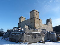
- Castles
- Castle of Boldogkő
- Castle Cserépvár
- Castle of Dédes
- Castle of Diósgyőr
- Castle of Füzér
- Castle of Sárospatak
- Castle of Szerencs
- Nature
- Dripstone cave of Aggtelek
- Bükk National Park
- Lillafüred
Gallery
-
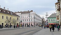 Miskolc, the capital of the county
 -

-
-
 Romanesque church in Vizsoly
 -
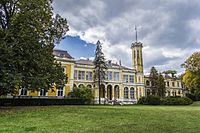
 L'Huillier-Coburg Palace in Edelény
 -
 Baradla Cave in the Aggtelek National Park
 -
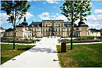
 Károlyi Mansion in Füzérradvány
 -
 Blower Engine Room in Ózd


.JPG)
.jpg)


_2.jpg)
International relations
Borsod-Abaúj-Zemplén County has a
|
|
References and notes
- References
- ^ nepesseg.com, population data of Hungarian settlements
- ^ Regions and Cities > Regional Statistics > Regional Economy > Regional GDP per Capita, OECD.Stats. Accessed on 16 November 2018.
- ISBN 9639069728. p. 41.
- ^ a b Decree about the coat of arms and flag of the county (PDF)
- ^ "Sátoraljaújhely, Hungary (English pages 79-109)".
- ^ népesség.com, "Borsod-Abaúj-Zemplén megye népessége 1870–2015"
- ^ 1.1.6. A népesség anyanyelv, nemzetiség és nemek szerint – Frissítve: 2013.04.17.; Hungarian Central Statistical Office (in Hungarian)
- ^ 2011. ÉVI NÉPSZÁMLÁLÁS, 3. Területi adatok, 3.5 Borsod-Abaúj-Zemplén megye, (in Hungarian) [1] Archived 1 April 2015 at the Wayback Machine
- ^ "Megyei közgyűlés tagjai 2019–2024 (Borsod-Abaúj-Zemplén megye)". valasztas.hu. Retrieved 29 October 2019.
- ^ Önkormányzati választások eredményei (in Hungarian)
- ^ "Borsod-Abaúj-Zemplén megye parlamenti képviselői (Parlamenti Információs Rendszer 2022-)" (in Hungarian). Hungarian National Assembly.
- Notes
- Mindenki Magyarországa.
External links
- Official website (in Hungarian)
- Borsod Online (boon.hu) – The county portal
- Official site deutsches office

| International | |
|---|---|
| National | |
| Geographic | |