
Bosanska Krajina

Bosanska Krajina (
The largest city, and its historical center is
Bosanska Krajina is not a formal entity within the structure of Bosnia and Herzegovina; however it has a significant cultural and historical identity that was formed through several historic and economic events. The territory of Bosanska Krajina is currently divided between two entities of Bosnia and Herzegovina: Republika Srpska and the Federation of Bosnia and Herzegovina.
Naming
During the
Geography

Sub-regions (geographical and historical) include: Bihaćka krajina, Cazinska krajina, Potkozarje, Lijevče, etc.
History
Middle Ages
In the 6th century, today's northwestern Bosnia was part of the
Archaeological data show that cemeteries of northwestern Bosnia clearly indicate that from the first half of the 10th century this territory was under political rule of the Croatian ruler.[8]
Northern parts of the territories were part of Slavonian Banate (parishes Sana, Vrbas and Dubica, and Lower Pounje was part of Zagreb parish) as lower S(c)lavonia, where parish Sana served as seat of Babonić family, and later the Blagaj family, and southern were parts of Pset and Pliva parish.
In the 13th and 14th century, from Pliva parish, a region called
By the 14th century, the Ottoman Empire had significantly expanded into the western Balkans in a series of wars, and the Turkish westward incursions eventually made this region an Ottoman borderland. Jajce had fallen to the Ottomans in 1463, marking the downfall of the Kingdom of Bosnia, although was later taken from the Ottomans and organized as defensive Banate of Jajce. The Battle of Krbava Field in 1493 effectively ended the Kingdom of Hungary's persistent hold over the entire region, restricting them to fortified cities, and when Jajce fell again in 1528, Ottoman rule persisted almost till the end of 19th. century.
In the late 15th century, a local Croatian lord (knez) Juraj Mikuličić erected a fort in the village of
Ottoman period
After the crucial 1526
Turkish incursions expanded further to the north, and
The Bužim fort, under Ottoman control since 1576, was successfully held by the Ottomans in numerous battles (1685, 1686, 1688, 1737) and it was also upgraded (1626, 1834) until their eventual surrender in the 19th century. The building remains to this day as a monument to the Ottoman conquest.[9]
Bihać held out longer than Bužim; it was a free royal city and at one time the capital of the Kingdom of Croatia (metropolis et propugnaculum totius regni Croatiae).
When the Ottoman Empire lost the 1683–1690 War of the Holy League to the Habsburg monarchy and her allies, and ceded Slavonia and Hungary to Austria at the 1699 Treaty of Karlowitz, the northern and western borders of the Sanjak of Bosnia (corresponding largely to the modern Bosnian borders), became a permanent frontier between the Austrian and Ottoman empires.
19th century
In mid-1858, an uprising known as Pecija's First Revolt broke out in the region, resulting from Ottoman pressure against the local Serb populace. It was crushed by December.
The Bosnian Frontier, like the rest of Bosnia and Herzegovina, participated in the 1875 – 1878
World War II

During World War II, Bosanska Krajina was known for its very strong resistance to the Fascist regime of the
Bosnian War
| 1991 | 1994 | |
|---|---|---|
| Serbs | 625,000 | 875,000 |
| Bosniaks and Croats | 550,000 | 50,000 |
During the 1992-95 Bosnian War, Bosanska Krajina was divided between Republika Srpska, the Republic of Bosnia and Herzegovina, and the Autonomous Province of Western Bosnia. The Serb entity of SAO Bosanska Krajina was established in summer 1991. The region was also a place of concentration camps, including Manjača and Omarska where Bosniaks were held, tortured, raped, and killed.
For the past two years, non-Serbs in the Bosanska Krajina area have been "cleansed" through systematic persecution that includes torture, murder, rape, beatings, harassment, de jure discrimination, intimidation, expulsion from homes, confiscation of property, bombing of businesses, dismissal from work, outlawing of all scripts except the Cyrillic in public institutions, and the destruction of cultural objects such as mosques and Catholic churches.
— Human Rights Watch report 1994[14]
Demography

The population of the region numbered almost one million before the Bosnian War. The composition of the current population of Bosanska Krajina has dramatically changed, because of expulsions, forced relocation and emigration during the Bosnian war in 1992–95.
Economics
In the immediate aftermath of World War II Bosanska Krajina was considered one of the poorest regions of Bosnia and Herzegovina. This poverty was a contributing factor to 1950
The later economic boom and prosperity of Bosanska Krajina was mostly due to planned urban development programs that were created specifically for this region in early and mid-1970s by Urban Institute in Banja Luka. The development was further stimulated by the simplification of the banking system that encouraged investments in resource processing industry. As a result, the region has seen a boom in agricultural and industrial production.
Agrokomerc, a food manufacturing industry located in northwest region was the largest food manufacturer in Bosnia and Herzegovina and former Yugoslavia. Other industries included chemical industry Saniteks in Velika Kladuša, electronics industry Rudi Cajevec in Banja Luka, Textile industry Sana in Bosanski Novi as well as a range of wood and food processing companies that stimulated an economic boom in this region. There was also a significant ore industry developed around the Kozara Mountain.
Transport and aviation

The expressway E-661 (locally known as M-16) leads north to Croatia, existing as an expressway from Banja Luka to Laktaši and as a two-lane road from Laktaši to the Bosnian/Croatian border. This second section of the road is currently being upgraded to an expressway.
Under planning is two new expressways. One from Prijedor to Bosanska Dubica to shorten the travelling time to Zagreb. The other one is to the east heading towards Doboj and connecting Bosanska Krajina to the important
Banja Luka International Airport is located 23 km from Banja Luka. There are two airlines currently, B&H Airlines and Adria Airways, with regular flights to Ljubljana (four times weekly) and Zürich (three times weekly). Charter flights also operate from the airport, and the airport can be used as a back-up to Sarajevo Airport. Zagreb Airport, due to weather conditions in winter often preferable to Sarajevo, is approximately two hours away from Banja Luka by car.
Željava Air Base, situated on the border between Croatia and Bosnia and Herzegovina under Plješevica Mountain, near the town of Bihać in Bosnia and Herzegovina, was the largest underground airport and military airbase in the former Yugoslavia and one of the largest in Europe.
Prijedor also has an airfield in the north-eastern part of the city in the area of Urije. The airfield has a fleet of light aircraft and sailplanes. The airfield was used by the Yugoslav partisans and was the first operative partisan airfield during World War II. The airfield also serves as the home of the city's renovated Parachuting club.
Bosanska Krajina is the hub of the railway services in Bosnia and Herzegovina, comprising more than one-half of the railway network of Bosnia and Herzegovina. Services operate to the northern and western Bosnian towns Banja Luka, Prijedor, Bosanski Novi and Bihać. The rail network also operates to Zagreb (twice daily), and Belgrade.
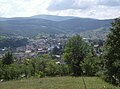
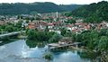
Gallery
-
 Banski dvor in Banja Luka
 -

-

-
-
-
-
-
-
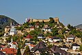
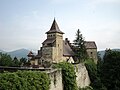
 Velika Kladuša Castle
 -
-

-

-
-

.jpg)


Historical gallery
-
 Banja Luka at the turn of the 20th century
 -
 Bihać fortified place in 1590
 -
 Bosanska Krupa from Middle Age
 -
 An old drawing ofBosanska Dubica


See also
References
- ^ ISBN 9958-766-00-0.
- ^ Dragomir Vukičić; Nevenka Gošić (1985). Collection of papers and materials of the fifth Yugoslav onomastic conference. Akademija nauka i umjetnosti Bosne i Hercegovine. p. 75.
- ^ ISBN 0-7146-8201-2.
- ^ Jayne, Kingsley Garland (1911). . In Chisholm, Hugh (ed.). Encyclopædia Britannica. Vol. 4 (11th ed.). Cambridge University Press. pp. 279–286.
Donji Kraj, the later Krajina, Kraina or Turkish Croatia, in the north-west
- Hrčak.
Schimek's Map of the Turkish Croatia, 1788. (Facsimile from Marković 1998). "Turkisch Croatien"
- ^ Fine 1991, p. 53.
- ^ Fine 1991, p. 262.
- Hrčak.
- ^ a b Commission to Preserve National Monuments, Sarajevo (2007-11-28). "Old Fort – Buzim – Bosnia and Herzegovina" (PDF). Council of Europe. Retrieved 2010-06-24.
- ^ admin (2016-12-06). "Osvajanje Bihaća 1592. godine - događaj kojim je cijeli prostor današnje Bosne i Hercegovine došao pod osmansku vlast". BOSNAE (in Bosnian). Retrieved 2022-08-26.
- ^ Noel Malcolm (1994). "The Vlachs in Bosnia". Bosnia: A Short History. New York University Press. Archived from the original on 2007-10-13. Retrieved 2010-06-18.
- ^ Hamdija Kreševljaković. "Stari bosanski gradovi. Vieux bourgs bosniaques" (PDF). p. 30. Retrieved 2019-11-11.
- ISBN 0-271-01629-9.
- ^ ""Ethnic Cleansing" Continues in Northern Bosnia" (PDF). Human Rights Watch. November 1994.
Sources
- Fine, John Van Antwerp Jr. (1991). The Early Medieval Balkans: A Critical Survey from the Sixth to the Late Twelfth Century. University of Michigan Press. ISBN 978-0-472-08149-3.
- Mrgić, Jelena; Živković, Tibor (2008). Северна Босна: 13-16. век. Историјски институт. ISBN 9788677430719.
44°46′N 17°11′E / 44.767°N 17.183°E
| International | |
|---|---|
| National | |