
Brahmagiri (Karnataka)
This article includes a improve this article by introducing more precise citations. (September 2018) ) |
| Brahmagiri | |
|---|---|
 Brahmagiri Brahmagiri (Karnataka)  Brahmagiri Brahmagiri (Kerala) | |
| Parent range | Western Ghats |
| Climbing | |
| Easiest route | Hike |
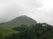
Brahmagiri, is a mountain range in the Western Ghats of south India. It is situated on the border between Kodagu district in Karnataka state in the north and Wayanad district of Kerala state on the south . Brahmagiri Hill, at 1608 m height, is a scenic tourist attraction. The top of Brahmagiri Hill is well forested and has much wildlife.
Tourist attractions
Thirunelli Temple, dedicated to Lord Vishnu, lies on the Kerala side of Brahmagiri. The temple was constructed in an ancient style and includes 30 granite pillars. According to legend, the temple was constructed by Lord Brahma himself.
Transportation
Brahmagiri can be reached by a trek from
The Periya ghat road connects Mananthavady to Kannur and Thalassery. The Thamarassery mountain road connects Calicut with Kalpetta. The Kuttiady mountain road connects Vatakara with Kalpetta and Mananthavady. The Palchuram mountain road connects Kannur and Iritty with Mananthavady. The road from Nilambur to Ooty is also connected to Wayanad through the village of Meppadi.
The nearest railway station is at Mysore and Thalassery and the nearest airports are
See also
- Thirunellitemple near Kattikkkulam town. There is an ancient cave on the hillock with plenty of birds.
- Mullayana Giri
- Baba Budan giri
- Kodachadri
- Pushpagiri
Gallery
- Brahmagiri
-
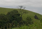
 Narimale or Tiger hill as known in the Kodava language.
 -
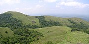
 Grassland and shola habitats.
 -
 'Munikal Caves'
 -
 Shola forests
 -


11°57′N 75°57′E / 11.950°N 75.950°E
External links
This article related to a location in Wayanad district, Kerala, India is a stub. You can help Wikipedia by expanding it. |
This article related to a location in Kodagu district, Karnataka, India is a stub. You can help Wikipedia by expanding it. |