
Breccia Peak (Wyoming)
| Breccia Peak | |
|---|---|
US 287 | |
| Highest point | |
| Elevation | 11,007 ft (3,355 m) |
| Prominence | 200 ft (61 m) |
| Parent peak | Buffalo Fork Peak |
| Coordinates | 43°47′16″N 110°04′29″W / 43.78782°N 110.07484°W |
| Geography | |
 Breccia Peak Wyoming | |
| Location | YDS Class 2) |
Breccia Peak is a mountain in the southern
Geography
Breccia Peak is located about 2.5 miles (4.0 km) north of Togwotee Pass, part of the Great Continental Divide which connects Jackson Hole from the west to the Wind River valley in the east. The plateau-like summit contains the steep and rocky Breccia Cliffs on its west and north faces, while a mainly grassy face exists to the east and south.[1]
Breccia Peak is the most prominent mountain in the immediate area, topping Buffalo Fork Peak to its north by about 200 feet (61 m). Higher peaks can be found along the Teton Range, located more than 30 miles (48 km) to the west.[2]
About 1.25 miles (2.01 km) southwest of Breccia Peak lies Lost Lake, located at an elevation of about 9,500 feet (2,900 m). This is a small but very scenic lake where the Breccia Cliffs reflect off the water during certain times of day.[3]

Geology
Breccia Peak is made of volcanic Absaroka
Climbing
Breccia Peak is a popular and accessible summit for hikers and climbers in the
At an elevation of 10,000 feet (3,000 m), climbers will find a vast meadow southeast of Breccia Peak where they can see the southeast face of the mountain entirely. To climb, the easiest route involves traversing the southeast face to reach the east ridge, avoiding a steep rocky cliff in the middle. From there, climbers can follow the east ridge to the summit. An alternative is to traverse the southwest face to the south ridge of Breccia Peak, and then follow this ridge to the summit.[2]
The southeast face of the mountain above the treeline is particularly suitable for backcountry skiing. The runs are short but quite varied.[5]
-
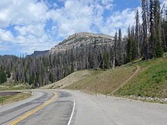 Breccia Peak from the pullout 0.6 miles north of Togwotee Pass, in the front the start of the track.
 -
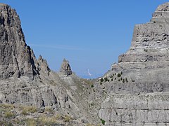
 Breccia Peak from southeast while ascending on normal route. The steep cliff in the middle can be passed on the left or on the right.
 -
 Northern cliffs of Breccia Peak.
 -
 First col between Breccia Peak (left) and Buffalo Fork Peak, Mount Moran in background.
 -
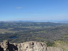 View from Breccia Peak to west, to Teton Range, Lost Lake in the foreground.
 -
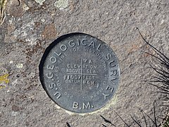 Survey marker at the summit of Breccia Peak.


References
- ^ "Breccia Peak". listsofjohn.com. Retrieved September 1, 2017.
- ^ a b c d "Breccia Peak". summitpost.org. Retrieved September 1, 2017.
- ISBN 978-1-4617-4576-1.
- ^ Antweiler, J. C.; Love, J. D.; Prostka, Harold J.; Kulik, Dolores M.; Anderson, Lennart A.; Williams, Frank E.; Jinks, Jimmie E.; Light, Thomas D. (1989). "Mineral Resources of the Teton Wilderness and Adjacent Areas, Teton, Fremont, and Park Counties, Wyoming" (PDF). U.S. Geological Survey Bulletin 1781. United States Government Printing Office. Plate 1.
- ^ "Breccia Peak Backcountry Skiing and Snowboarding". rootsrated.com. Archived from the original on September 1, 2017. Retrieved September 1, 2017.
External links
 Definitions from Wiktionary
 Media from Commons
 News from Wikinews
 Quotations from Wikiquote
 Texts from Wikisource
 Textbooks from Wikibooks
 Resources from Wikiversity