
Brenan Park
| Brenan Park | |
|---|---|
John Ryan Brenan | |
| Operated by | Fairfield City Council |
| Open | 24 hours |
| Status | Open all year |
Brenan Park is a 20-hectare (49-acre)
History
The shape of Brenan Park appears on the first survey design, in 1838, of the market town sketched for John Ryan Brenan.[3] Brenan Park was planned to be a housing subdivision and a market area in 1938, with its triangular shape fashioned to take advantage of the topography and views of the surrounding district. The housing subdivision was never constructed.
The site was used as a sewage disposal depot and landfill until 1980, where it was proclaimed as unhealthy building land in 1981. Subsequently, it was re-landscaped and eventually developed into a reserve.[4]
Geography
The reserve is located in the suburb of Smithfield, and is bordered by Cumberland Highway, Brenan and Bourke Streets, which all give good passive surveillance opportunities from close residences and contiguous roads. The park's surrounds are mainly single-story houses.[5]
Brenan Park is in an
Ecology
Indigenous trees and shrubs are abundant in the park, with dominant vegetation species being Melaleuca quinquenervia (near the tennis courts), Eucalyptus moluccana
(near the car park in Brenan Street),
The boundary along the top part of Bourke Street and near Cumberland Highway is thickly planted with an avenue of trees and shrubs, which provide a sense of entry to the park. The park is predominantly made up of sod and it lies on residual soils that are 1,000-millimetre (39 in) deep. Its trees represent a link to the Cumberland Plain Woodland that covered most of Fairfield local government area before European settlement. There is a shrubby, dry sclerophyll bushland area to the south of the park, near Cumberland Highway.[8]
The corner of Brenan Street and Cumberland Highway provides good viewing site for
Features

The park features six tennis courts, nine soccer fields (six which are full-sized), three cricket pitches, baseball and softball diamonds, three children's playgrounds, picnic areas (with barbeque), an outdoor gym and a 2 km-long (1.2 mi) walking track (shared with cycling) that circuits the park. The park has open space which can be used for kiting and other activities when they are not being used for sport.[1]
The park is
Clubs
The sports fields are hired by these sporting groups:
- Smithfield RSL Cricket Club
- Smithfield RSL Soccer Club
- Fairfield Patrician Brothers Soccer Club
- Smithfield RSL Baseball Club
Gallery
-
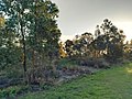 A bushland in the park's southern vicinity.
 -
 Cumberland Highway as seen from the Brenan Park walking track.
 -
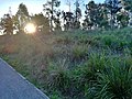 A sloped shrubby area near the walking track to the south of the park.


See also
- Wetherill Park Nature Reserve
- Fairfield Park Precinct
- Western Sydney Parklands
- Central Gardens Nature Reserve
- Rosford Street Reserve
References
- ^ a b Michael King & Associates (1997). Recreation Needs Assessment Study prepared for Fairfield City Council.
- ^ Know your suburb. Fairfield City Council. February 1999.
{{cite book}}:|work=ignored (help) - ^ George, V. (1991). Fairfield – A History of the District (Second ed.). Fairfield City Council.
- ^ Clouston (1999). Fairfield Open Space Strategy prepared for Fairfield City Council.
- ^ Strategic Plan for Fairfield City 1999-2010. Fairfield City Council. 1999.
- ^ Local Environment Plan. Fairfield City Council. 1994.
- ^ Woodward Clyde Environmental Consultants (1992). Environmental reports in Brenan Park Property Files for Fairfield City Council.
- ^ Management Plan for Fairfield City 1999-2003. Fairfield City Council. 1999.
- ^ Fairley, A.; Moore, P. (1995). Native Plants of Sydney District – an identification guide. Sydney: Kangaroo Press.
- ^ Vision for Fairfield. Fairfield City Council. December 1999.