
Brickell Avenue
| |
|---|---|
| Location | |
| Country | United States |
| Counties | Miami-Dade |
| Highway system | |
Brickell Avenue is a north–south road that is part of
It is a grid plan main north–south thoroughfare through the south part of Miami's central business district.
Route description
Brickell Avenue from the Miami River south it continues south-southwest and upon crossing Broadway/SE 15th Street it curves southwest and continues in that direction until it terminates at Southeast 26th Road/
Notable attractions on Brickell Avenue
Brickell's cultural significance has arguably surpassed downtown because its bar and restaurant zone brings in large crowds well into late night - early morning hours. Popular restaurants on Brickell Avenue include Komodo, La Petit Maison, Truluck's, and Cipriani.
Many of the restaurants on Brickell Ave transform from bright, open restaurants during the day to inviting and sensual by night. Some of the places include Barsecco, Baby Jane Cocktail & Noodle Bar, and The Bar at Level 25.
There are also a few historic places on Brickell Ave such as Brickell Mausoleum and Villa Serena, a home built on the former "Millioniare's Mile" for William Jennings Bryan, a former politician in 1913.
Major intersections
The entire route is in
| mi[1] | km | Destinations | Notes | ||
|---|---|---|---|---|---|
| 0.0 | 0.0 | Access to tolled Rickenbacker Causeway via SR 913 east | |||
| 1.1 | 1.8 | SR 972 west (SE 13th Street / Coral Way) | Eastern terminus of SR 972 | ||
| 1.5 | 2.4 | Eastern terminus of US 41 | |||
| 1.7 | 2.7 | Brickell Avenue Bridge over the Miami River | |||
| 1.8 | 2.9 | Biscayne Boulevard Way ) | |||
| 1.000 mi = 1.609 km; 1.000 km = 0.621 mi | |||||
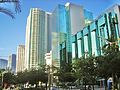
Gallery
-
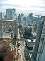 Aerial view of Brickell Avenue, as seen from the Viceroy Tower's skydeck
 -
-
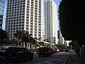
 Looking south
 -
 Looking north
 -


References
- ^ a b Google (January 1, 2020). "Brickell Avenue" (Map). Google Maps. Google. Retrieved January 1, 2020.
- ^ Arva Moore Parks; Sarah E. Eaton (June 17, 1997). George E. Nolan House, 1548 Brickell Avenue: Designation Report (PDF) (Report). City of Miami. p. 7. Archived from the original (PDF) on July 14, 2010. Retrieved November 18, 2012.
By the time the railroad arrived in 1896, spurred in part by the Brickells' gift of land to Henry Flagler, the Brickells had already paved a rock road, known as the Coconut Grove Trail, through their property. In 1898, the trail became a 145 foot wide roadway called Brickell Avenue and extended from the Miami River to Broadway (15th Road).
- ^ "Brickell Avenue Neighborhood Guide". Archived from the original on February 6, 2010. Retrieved February 4, 2010.
25°45′58″N 80°11′27″W / 25.766233°N 80.190711°W
This article relating to the United States Numbered Highway System is a stub. You can help Wikipedia by expanding it. |