
Brie, Somme
Brie | |
|---|---|
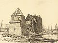
.JPG) The church in Brie | |
 Coat of arms | |
Location of Brie  | |
 Brie  Brie | |
| Coordinates: 49°52′33″N 2°55′56″E / 49.8759°N 2.9322°E | |
| Country | France |
| Region | Hauts-de-France |
| Department | Somme |
| Arrondissement | Péronne |
| Canton | Péronne |
| Intercommunality | Haute Somme |
| Government | |
| • Mayor (2020–2026) | Marc Saintot[1] |
| Area 1 | 6.89 km2 (2.66 sq mi) |
| Population (2021)[2] | 333 |
| • Density | 48/km2 (130/sq mi) |
| Time zone | UTC+01:00 (CET) |
| • Summer (DST) | UTC+02:00 (CEST) |
| INSEE/Postal code | 80141 /80200 |
| Elevation | 47–87 m (154–285 ft) (avg. 50 m or 160 ft) |
| 1 French Land Register data, which excludes lakes, ponds, glaciers > 1 km2 (0.386 sq mi or 247 acres) and river estuaries. | |
Brie (French pronunciation: [bʁi] ⓘ) is a commune in the Somme department in Hauts-de-France in northern France.
Geography
Brie is situated 16 miles (26 km) west of Saint-Quentin and about 10 kilometres (6.2 mi) south of Péronne, on the banks of the river Somme, where it is crossed by the N39.
Physical geography
The majority of the soil of the commune is of clay-limestone nature.1/5 of the subsoil is of limestone nature and 1/50 of the soil of sandy nature.
Relief, landscape, vegetation
The relief of the commune is that of a plateau, which culminates at 70 metres (230 ft) of altitude. The village built on the western slope of the plateau dominates the valley of the Somme and its lakes.
Hydrography
The river Somme touches the communal territory at its western extremity. On its entrance into the territory of Brie, the river divides into two arms, which meet soon after. The water table is located at a little distance from the level of the ponds.
Climate
The climate of the municipality is
Human geography
Urban planning and land use planning
The commune has a grouped habitat. The village of Brie was destroyed during the
Economic activity and services
Roads of communication and transportation
Brie is crossed by the road Amiens-Saint-Quentin and the road that connects Saint-Christ-Briost to Mesnil-Bruntel.
History
Toponymy
The name Brie comes from the Latin bria or the Celtic briga, which meant bridge over a river.
Ancient history
In front of the church, presence of prehistoric megalith "the turning stone".[clarification needed]
Antiquity
Brie being situated on the
Middle Ages
In the Middle Ages, Pont-lès-Brie and Applaincourt were dependencies of Brie. In 1303, by a charter, Gérin de Saint-Christ sold a wood near Brie in the priory of Lihons-en-Santerre. In 1344 a certain Jean de Brie was a maid of Péronne.
Coat of arms
The village coat of arms is "azure to the golden chevron accompanied by three half-flights of silver, those of the head back." The official status of the coat of arms remains to be determined.
Early Modern times
In 1571, the lordship of Brie belonged to the
During the French Revolution, the hamlets of Pont-lès-Brie and Applaincourt were attached to the commune of Villers-Carbonnel.
In 1814–1815, the coalition armies ravaged the country.
In 1870–1871, the population of Brie underwent the requisitions of the German army, in money and in kind. 24 young people of the commune took part in the fighting, two were wounded.
Modern history
During the
-
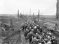 Sherwood Foresters following up Germans near Brie March
 -
-
 British bicycle troops Brie, Somme March 1917
 -
 British troops in Brie, Somme March 1917


Politics
The mayor is Marc Saintot, elected in 2020.[1]
Population
In 2017, the municipality had 331 inhabitants, an increase of 1.8% compared to 2007.
| Year | Pop. | ±% p.a. |
|---|---|---|
| 1968 | 319 | — |
| 1975 | 299 | −0.92% |
| 1982 | 310 | +0.52% |
| 1990 | 307 | −0.12% |
| 1999 | 301 | −0.22% |
| 2007 | 325 | +0.96% |
| 2012 | 341 | +0.97% |
| 2017 | 331 | −0.59% |
| Source: INSEE[4] | ||
See also
References
- ^ a b "Répertoire national des élus: les maires". data.gouv.fr, Plateforme ouverte des données publiques françaises (in French). 2 December 2020.
- ^ "Populations légales 2021". The National Institute of Statistics and Economic Studies. 28 December 2023.
- ^ Abbé Paul Decagny, L'Arrondissement de Péronne ou recherches sur les villes, bourgs, villages et hameaux qui le composent, 1844 - réédition partielle sous le titre, Péronne et son canton, Inval-Boiron, La Vague verte, 2010.
- ^ Population en historique depuis 1968, INSEE
| Authority control databases: National |
|---|