
Brisbane
| Brisbane Meanjin ( 17 divisions | |||||||||
|---|---|---|---|---|---|---|---|---|---|
| |||||||||
Brisbane (/ˈbrɪzbən/ ⓘ BRIZ-bən,[9] Turrbal: Meaanjin) is the capital of the state of Queensland[10] and the third-most populous city in Australia and Oceania, with a population of approximately 2.6 million.[11] Brisbane lies at the centre of South East Queensland, which includes several other regional centres and cities. The central business district is situated within a peninsula of the Brisbane River about 15 km (9 mi) from its mouth at Moreton Bay.[12] Brisbane is located in the hilly floodplain of the Brisbane River Valley between Moreton Bay and the Taylor and D'Aguilar mountain ranges.[13] It sprawls across several local government areas, most centrally the City of Brisbane. The demonym of Brisbane is Brisbanite.[14][15]
The
Brisbane is a major centre of research and innovation in the
, Australia's third-largest seaport.A diverse city with over 36% of its metropolitan population being foreign-born, Brisbane is frequently ranked highly in lists of the
Brisbane is a popular tourist destination. Major landmarks and attractions include South Bank Parklands, the City Botanic Gardens, King George Square and City Hall, the Story Bridge, the Mount Coot-tha Botanic Gardens and Lookout and the Lone Pine Koala Sanctuary.
Name
Brisbane is named after the Brisbane River, which in turn was named after Sir Thomas Brisbane, the governor of New South Wales from 1821 to 1825. The name is derived from the Scottish Gaelic bris, meaning "to break or smash" and the Old English word ban meaning bone.
A historic nickname for Brisbane was the "Queen City of the North",[22] whilst more recent for popular nicknames for the city include Brissie, Brisvegas, and the River City.[23][22]
Brisbane sits on land known also as Meanjin, the name used in the
Aboriginal groups claiming
History
Pre-colonisation
Archaeological evidence suggests frequent habitation around the Brisbane River, and notably at the site now known as Musgrave Park.[46] The rivers were integral to life and supplied an abundance of food included fish, shellfish, crab, and prawns. Good fishing places became campsites and the focus of group activities. The district was defined by open woodlands with rainforest in some pockets or bends of the Brisbane River.[47]
Being a resource-rich area and a natural avenue for seasonal movement, Meanjin and the surrounding areas acted as a way station for groups travelling to ceremonies and spectacles. The region had several large (200–600 person) seasonal camps, the biggest and most important located along waterways north and south of the current city heart: Barambin or "York's Hollow" camp (today's
18th and 19th centuries
In 1770, British navigator James Cook, sailed through South Passage between the main offshore islands leading to the bay, which he named after James Douglas, 14th Earl of Morton, misspelled as "Moreton".[49]
Matthew Flinders initially explored the Moreton Bay area on behalf of the British authorities. On 17 July 1799, Flinders landed at present-day Woody Point, which he named "Red Cliff Point" after the red-coloured cliffs visible from the bay.[50]
In 1823 the Governor of New South Wales, Sir Thomas Brisbane, gave instructions for the development of a new northern penal settlement, and an exploration party commanded by John Oxley further explored Moreton Bay in November 1823.[51]

Oxley explored the Brisbane River as far as
After visiting the Redcliffe settlement, Sir Thomas Brisbane then travelled 45 km (28 mi) up the Brisbane River in December 1824. Governor Brisbane stayed overnight in a tent and often landed ashore, thus bestowing upon the future Brisbane City the distinction of being the only Australian capital city visited by its namesake.[54] Chief Justice Forbes gave the new settlement the name of "Edenglassie" before it was named "Brisbane".[55][need quotation to verify]
The penal settlement under the control of Captain Patrick Logan (Commandant from 1826 to 1830) flourished, with the numbers of convicts increasing dramatically from around 200 to over 1,000 men.[56] He developed a substantial settlement of brick and stone buildings, complete with school and hospital. He formed additional outstations and made several important journeys of exploration. Logan became infamous for his extreme use of the cat o' nine tails on convicts. The maximum allowed limit of lashes was 50; however, Logan regularly applied sentences of 150 lashes.[56]
During this period raids on maize fields were conducted by local Aboriginal groups in the

Between 1824 and 1842, almost 2,400 men and 145 women were detained at the Moreton Bay convict settlement under the control of military commandants.
Scottish immigrants from the ship
Free settlers entered the area from 1835,[
During the
In 1864, the Great Fire of Brisbane burned through the central parts of the city, destroying much of Queen Street.[74] The 1860s were a period of economic and political turmoil leading to high unemployment, in 1866 hundreds of impoverished workers convened a meeting at the Treasury Hotel, with a cry for "bread or blood", rioted and attempted to ransack the Government store.[75]
The

Charles Tiffin was appointed as Queensland Government Architect in 1859, and pursued an intellectual policy in the design of public buildings based on Italianate and Renaissance revivalism, with such buildings as Government House, the Department of Primary Industries Building in 1866, and the Queensland Parliament built in 1867. The 1880s brought a period of economic prosperity and a major construction boom in Brisbane, that produced an impressive number of notable public and commercial buildings. John James Clark was appointed Queensland Government Architect in 1883, and continuing in Tiffin's design for public buildings, asserted the propriety of the Italian Renaissance, drawing upon typological elements and details from conservative High Renaissance sources. Building in this trace of intellectualism, Clark designed the Treasury Building in 1886, and the Yungaba Immigration Centre in 1885.[80] Other major works of the era include Customs House in 1889, and the Old Museum Building completed in 1891.
Fort Lytton was constructed in 1882 at the mouth of the Brisbane river, to protect the city against foreign colonial powers such as Russia and France, and was the only moated fort ever built in Australia.
The city's slum district of

In 1893 Brisbane was affected by the Black February flood, when the Brisbane River burst its banks on three occasions in February and again in June in the same year, with the city receiving more than a year's rainfall during February 1893, leaving much of the city's population homeless. In 1896, the Brisbane river saw its worst maritime disaster with the capsize of the ferry Pearl, between the 80–100 people on board there were only 40 survivors.[82]
20th century
When the colonies united in a federation in 1901, celebrations were held in Brisbane to mark the event, with a

In 1912, Tramway employees were stood down for wearing union badges which sparked Australia's first
Russian immigration took place in the years 1911–1914. Many were radicals and revolutionaries seeking asylum from tsarist political repression in the final chaotic years of the Russian Empire; considerable numbers were Jews escaping state-inspired pogroms. They had fled Russia via Siberia and Northern China, most making their way to Harbin, in Manchuria, then taking passage from the port of Dalian to Townsville or Brisbane, the first Australian ports of call.[83]
Following the

.jpg)
These historic buildings, along with the
In 1939, armed farmers marched on the Queensland Parliament and stormed the building in an attempt to take hostage the Queensland Government led by Labor Premier William Forgan Smith, in an event that became known as the "Pineapple rebellion".[87]

During World War II, Brisbane became central to the Allied campaign, since it was the northernmost city with adequate communications facilities. From July 1942 to September 1944, AMP Building (now called MacArthur Central) was used as the headquarters for South West Pacific Area under General MacArthur. MacArthur had previously rejected use of the University of Queensland complex as his headquarters, as the distinctive bends in the river at St Lucia could have aided enemy bombers. Also used as a headquarters by the American troops during World War II was the T & G Building.[88] About one million US troops passed through Australia during the war, as the primary co-ordination point for the South West Pacific.[89] Wartime Brisbane was defined by the racial segregation of African American servicemen, prohibition and sly grog, crime, and jazz ballrooms.[90][91]
In 1942, Brisbane was the site of a violent clash between visiting US military personnel and Australian servicemen and civilians, which resulted in one death and hundreds of injuries. This incident became known colloquially as the "Battle of Brisbane".[92]
Post-war Brisbane had developed a "big country town" stigma, an image the city's politicians and marketers were very keen to remove.[93] In the late 1950s, an anonymous poet known as The Brisbane Bard generated much attention to the city which helped shake this stigma.[94][95] In 1955, Wickham Terrace was the site of a terrorist incident involving shootings and bombs, by the German immigrant Karl Kast. Despite steady growth, Brisbane's development was punctuated by infrastructure problems. The state government under Joh Bjelke-Petersen began a major programme of change and urban renewal, beginning with the central business district and inner suburbs. Trams in Brisbane were a popular mode of public transport until the network was closed in 1969, in part the result of the Paddington tram depot fire.
Between 1968 and 1987, Queensland was governed by Bjelke-Petersen, whose government was characterised by
In 1971, the touring
In the lead up to the 1980s Queensland fell subject to many forms of censorship. In 1977 things had escalated from prosecutions and book burnings, under the introduction of the Literature Board of Review, to a statewide ban on protests and street marches. In September 1977 the Queensland Government introduced a ban on all street protests, resulting in a statewide civil liberties campaign of defiance.[99] This saw two thousand people arrested and fined, with another hundred being imprisoned, at a cost of almost five million dollars to the State Government.[100] Bjelke-Petersen publicly announced on 4 September 1977 that "the day of the political street march is over ... Don't bother to apply for a permit. You won't get one. That's government policy now."[101] In response to this, protesters came up with the idea of Phantom Civil Liberties Marches where protesters would gather and march until the police and media arrived. They would then disperse, and gather together again until the media and police returned, repeating the process over and over again.[102]
The end of the Bjelke-Petersen era began with the
In 1973, the
.jpg)
Brisbane hosted the
21st century
Brisbane was impacted by major floods in January 2011 and February 2022. The Brisbane River did not reach the same height as the previous 1974 flood on either occasion, but caused extensive disruption and damage to infrastructure.[107][108]
The Queensland Cultural Centre was also expanded, with the completion of the State Library and the Gallery of Modern Art in 2006, and the Kurilpa Bridge in 2009, the world's largest hybrid tensegrity bridge.[109] Brisbane also hosted major international events including the final Goodwill Games in 2001, the Rugby League World Cup final in 2008 and again in 2017, as well as the 2014 G20 Brisbane summit.
Population growth has continued to be among the highest of the Australian capital cities in the first two decades of the 21st century, and major infrastructure including the
railway lines have been completed or are under construction.Brisbane will host the 2032 Summer Olympics and 2032 Summer Paralympics.[110][111]
Geography and environment


Brisbane is in the southeast corner of Queensland. The city is centred along the Brisbane River, and its eastern suburbs line the shores of Moreton Bay, a bay of the Coral Sea. The greater Brisbane region is on the coastal plain east of the
The Brisbane River is a wide
The waters of Moreton Bay are sheltered from large swells by Moreton, Stradbroke and Bribie islands, so whilst the bay can become rough in windy conditions, the waves at the Moreton Bay coastline are generally not surfable. Unsheltered surf beaches lie on the eastern coasts of Moreton, Stradbroke and Bribie islands and on the Gold Coast and Sunshine Coast to the south and north respectively. The southern part of Moreton Bay also contains smaller islands such as St Helena Island, Peel Island, Coochiemudlo Island, Russell Island, Lamb Island and Macleay Island.
The city of Brisbane is hilly.
Much of the rock upon which Brisbane is located is the characteristic Brisbane tuff, a form of welded ignimbrite,[115] which is most prominently found at the Kangaroo Point Cliffs at Kangaroo Point and the New Farm Cliffs on the Petrie Bight reach of the Brisbane River. The stone was used in the construction of historical buildings such as the Commissariat Store and Cathedral of St Stephen, and the roadside kerbs in inner areas of Brisbane are still manufactured of Brisbane tuff.
Ecology

Brisbane is located within the
Brisbane is home to numerous bird species, with common species including
Climate

Brisbane has a humid subtropical climate (Köppen climate classification: Cfa)[120] with hot, wet summers and moderately drier, mild winters.[121][122] Brisbane experiences an annual mean minimum of 16.6 °C (62 °F) and mean maximum of 26.6 °C (80 °F), making it Australia's second-hottest capital city after Darwin.[123] Seasonality is not pronounced, and average maximum temperatures of above 26 °C (79 °F) persist from October through to April.
Due to its proximity to the Coral Sea and a warm ocean current, Brisbane's overall temperature variability is somewhat less than most Australian capitals. Summers are long, hot, and wet, but temperatures only occasionally reach 35 °C (95 °F) or more. Eighty percent of summer days record a maximum temperature of 27 to 33 °C (81 to 91 °F). Winters are short and warm, with average maximums of about 22 °C (72 °F); maximum temperatures below 20 °C (68 °F) are rare.
The city's highest recorded temperature was 43.2 °C (109.8 °F) on Australia Day 1940 at the Brisbane Regional Office,[124] with the highest temperature at the current station being 41.7 °C (107.1 °F) on 22 February 2004;[125] but temperatures above 38 °C (100 °F) are uncommon. On 19 July 2007, Brisbane's temperature fell below the freezing point for the first time since records began, registering −0.1 °C (31.8 °F) at the airport station.[126] The city station has never dropped below 2 °C (36 °F),[127] with the average coldest night during winter being around 6 °C (43 °F), however locations in the west of the metropolitan area such as Ipswich have dropped as low as −5 °C (23 °F) with heavy ground frost.[128]
In 2009, Brisbane recorded its hottest winter day (from June to August) at 35.4 °C (95.7 °F) on 24 August;[129] The average July day however is around 22 °C (72 °F) with sunny skies and low humidity, occasionally as high as 27 °C (81 °F), whilst maximum temperatures below 18 °C (64 °F) are uncommon and usually associated with brief periods of cloud and winter rain.[127] The highest minimum temperature ever recorded in Brisbane was 28.0 °C (82.4 °F) on 29 January 1940 and again on 21 January 2017, whilst the lowest maximum temperature was 10.2 °C (50.4 °F) on 12 August 1954.[124]
Annual precipitation is ample. From November to March, thunderstorms are common over Brisbane, with the more severe events accompanied by large damaging hail stones, torrential rain and destructive winds. On an annual basis, Brisbane averages 124 clear days..
Brisbane is within the southern reaches of the tropical cyclone risk zone. Full-strength tropical cyclones rarely affect Brisbane, but occasionally do so. The biggest risk is from ex-tropical cyclones, which can cause destructive winds and flooding rains.[131]
The average annual temperature of the sea ranges from 21.0 °C (69.8 °F) in July to 27.0 °C (80.6 °F) in February.[132]
| Climate data for Brisbane (Brisbane, 1999–2022) | |||||||||||||
|---|---|---|---|---|---|---|---|---|---|---|---|---|---|
| Month | Jan | Feb | Mar | Apr | May | Jun | Jul | Aug | Sep | Oct | Nov | Dec | Year |
| Record high °C (°F) | 40.0 (104.0) |
41.7 (107.1) |
37.9 (100.2) |
33.7 (92.7) |
30.7 (87.3) |
29.0 (84.2) |
29.1 (84.4) |
35.4 (95.7) |
37.0 (98.6) |
38.7 (101.7) |
38.9 (102.0) |
41.2 (106.2) |
41.7 (107.1) |
| Mean daily maximum °C (°F) | 30.4 (86.7) |
30.1 (86.2) |
29.1 (84.4) |
27.2 (81.0) |
24.5 (76.1) |
22.0 (71.6) |
22.0 (71.6) |
23.4 (74.1) |
25.7 (78.3) |
27.1 (80.8) |
28.3 (82.9) |
29.6 (85.3) |
26.6 (79.9) |
| Daily mean °C (°F) | 26.0 (78.8) |
25.8 (78.4) |
24.8 (76.6) |
22.3 (72.1) |
19.2 (66.6) |
17.0 (62.6) |
16.2 (61.2) |
17.2 (63.0) |
19.8 (67.6) |
21.8 (71.2) |
23.6 (74.5) |
25.0 (77.0) |
21.5 (70.7) |
| Mean daily minimum °C (°F) | 21.6 (70.9) |
21.4 (70.5) |
20.2 (68.4) |
17.4 (63.3) |
13.8 (56.8) |
11.9 (53.4) |
10.4 (50.7) |
10.9 (51.6) |
13.9 (57.0) |
16.5 (61.7) |
18.8 (65.8) |
20.5 (68.9) |
16.4 (61.5) |
| Record low °C (°F) | 17.0 (62.6) |
16.5 (61.7) |
12.2 (54.0) |
10.0 (50.0) |
5.0 (41.0) |
5.0 (41.0) |
2.6 (36.7) |
4.1 (39.4) |
7.0 (44.6) |
8.8 (47.8) |
10.8 (51.4) |
14.0 (57.2) |
2.6 (36.7) |
| Average precipitation mm (inches) | 138.1 (5.44) |
185.2 (7.29) |
131.6 (5.18) |
61.3 (2.41) |
61.1 (2.41) |
63.8 (2.51) |
27.5 (1.08) |
34.2 (1.35) |
26.6 (1.05) |
86.3 (3.40) |
95.7 (3.77) |
129.1 (5.08) |
1,011.5 (39.82) |
| Average rainy days (≥ 1 mm) | 8.2 | 10 | 9.7 | 7 | 5.6 | 6.6 | 3.8 | 3.5 | 3.6 | 7.1 | 7.6 | 8.9 | 81.6 |
| Average afternoon relative humidity (%)
|
57 | 59 | 57 | 54 | 49 | 52 | 44 | 43 | 48 | 51 | 56 | 57 | 52 |
| Mean monthly sunshine hours | 267 | 235 | 233 | 237 | 239 | 198 | 239 | 270 | 267 | 270 | 273 | 264 | 2,989 |
| Percent possible sunshine | 63 | 65 | 62 | 69 | 71 | 63 | 73 | 78 | 74 | 68 | 67 | 62 | 68 |
| Average ultraviolet index | 13 | 12 | 10 | 7 | 5 | 4 | 4 | 5 | 7 | 10 | 12 | 13 | 9 |
| Source: Bureau of Meteorology[133] | |||||||||||||
Urban structure
The
The CBD's squares include King George Square, Post Office Square and ANZAC Square (home to the city's central war memorial).
Brisbane's metropolitan area is broadly and colloquially divided into the northside and the southside, with the dividing line being the Brisbane River,[134] as crossing one of the 15 bridges across the river is required to travel to the opposite side by land transport. This results in many areas which are south of the CBD being classified as located in the northside, and vice versa, as a result of the river's winding, mostly south-west, trajectory. In addition to being classified as located on the northside or southside there are further broad and colloquial regions such as the westside for some areas to the southwest of the CBD and the bayside for areas located on the coast of Moreton Bay.
Greater Brisbane had a density of 159 inhabitants per square kilometre (410/sq mi) in 2021.[2] Like most Australian cities, Brisbane has a sprawling metropolitan area which takes in excess of one hour to traverse either north to south or east to west by car without traffic.
From the 1970s onwards, there has been a large increase in the construction of
Parklands

Brisbane's major parklands include the riverside City Botanic Gardens at Gardens Point,[135] Roma Street Parkland, the 27-hectare Victoria Park at Spring Hill and Herston, South Bank Parklands along the river at South Bank, the Brisbane Botanic Gardens at Mount Coot-tha and the riverside New Farm Park at New Farm.
There are many national parks surrounding the Brisbane metropolitan area. The D'Aguilar National Park is a major national park along the northwest of the metropolitan area in the D'Aguilar Range. The Glass House Mountains National Park is located to the north of the metropolitan area in the Glass House Mountains and provides green space between the Brisbane metropolitan area and the Sunshine Coast. The Tamborine National Park at Tamborine Mountain is located in the Gold Coast hinterland to the south of the metropolitan area.
The eastern metropolitan area is built along the
Brisbane Exhibition Ground | |
28 | Brisbane Riverwalk |
| Inner City Bypass (rail) (left) (road) (right) | |
30 | Indooroopilly Golf Course |
| Howard Smith Wharves | |
| Eagle Street Pier | |
| Queen Street Mall | |
Architecture
Brisbane has a number of heritage buildings, some of which date back to the 1820s, including The Old Windmill in Wickham Park, built by convict labour in 1824,[136] which is the oldest surviving building in Brisbane, and the Commissariat Store on William Street, built by convict labour in 1828, which was originally used as a grain house, and is now the home of the Royal Historical Society of Brisbane and contains a museum.[137][138][139] Other 19th and early 20th-century buildings of architectural significance include the Treasury Building, City Hall, Customs House, Land Administration Building, MacArthur Chambers, The Mansions, National Australia Bank Building, and the Federation-style People's Palace, a former temperance hotel on Edward Street.
Brisbane is home to several of Australia's tallest buildings. All of Brisbane's skyscrapers (buildings with a height greater than 150 m (490 ft)) are located within the CBD, but the inner suburbs are also home to a number of high-density buildings, Torbreck being the first high-rise and mix-use residential development in Queensland. Brisbane's 91-metre City Hall was the city's tallest building for decades after its completion in 1930 and was finally surpassed in 1970, which marked the beginning of the widespread construction of high-rise buildings.[citation needed]
Brisbane's tallest building is currently Brisbane Skytower, which has a height of 270 m (890 ft).[140] Architecturally prominent skyscrapers include the Harry Seidler-designed Riparian Plaza, One One One Eagle Street, which incorporates LED lighting resembling the buttress roots of the Moreton Bay fig, and 1 William Street, the executive headquarters of the Queensland Government.
-
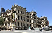 19th century sandstone Treasury Building
 -
 Former temperance hotel, the People's Palace, was built in the Federation Filigree style between 1910 and 1911.
 -
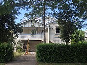 Queenslander-style house in Hendra, a suburb of Brisbane
 -
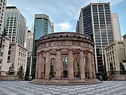 Shrine of remembrance at the ANZAC Square is a major memorial in Brisbane


Demographics
Brisbane's Greater Capital City Statistical Area includes the Local Government Areas of City of Brisbane, City of Ipswich, City of Moreton Bay, Logan City and Redland City, as well as parts of Lockyer Valley Region, Scenic Rim Region and Somerset Region, which form a continuous metropolitan area. The Australian Bureau of Statistics estimates that the population of Greater Brisbane is 2,560,720 as of June 2020,[11] making it the third-largest city in Australia.
Ancestry and immigration
| Birthplace[N 1] | Population |
|---|---|
| Australia | 1,726,655 |
| New Zealand | 111,649 |
| England | 95,284 |
| India | 51,650 |
| Mainland China | 41,978 |
| Philippines | 27,907 |
| South Africa | 26,918 |
| Vietnam | 20,308 |
| South Korea | 13,305 |
| Taiwan | 12,826 |
| Scotland | 11,956 |
| Malaysia | 11,826 |
| Fiji | 10,800 |
| United States | 10,530 |
| Hong Kong SAR | 9,799 |

At the 2021 census, the most commonly nominated ancestries were:
- English (32.5%)
- Australian (31.6%)[N 2]
- Irish (11.1%)
- Scottish (10.1%)
- German (5.7%)
- Chinese (4.7%)
- Indonesian (3.7%)
- Aboriginal (2.8%)[N 3]
- Italian (2.7%)
- Indian (2.4%)
- Dutch (1.6%)
- Filipino (1.6%)
- Maori (1.5%)
- New Zealander (1.4%)
- Samoan (1.2%)
- Vietnamese (1.1%)
The 2021 census showed that 20.7% of Brisbane's inhabitants were born overseas and 25.2% of inhabitants had at least one parent born overseas.[142] Brisbane has the 26th largest immigrant population among world metropolitan areas. Of inhabitants born outside of Australia, the five most prevalent countries of birth were New Zealand, England, India, mainland China and the Philippines.
The areas of Sunnybank,[143] Sunnybank Hills,[144] Stretton,[145] Robertson,[146] Calamvale,[147] Macgregor,[148] Eight Mile Plains,[149] Runcorn,[150] and Rochedale,[151] are home to a large proportion of Brisbane's Mainland China, Taiwan and Hong Kong-born population, with Chinese being the most commonly-reported ancestry in each of these areas. The Vietnamese-born are the largest immigrant group in Inala,[152] Darra,[153] Durack,[154] Willawong,[155] Richlands,[156] and Doolandella.[157] The Indian-born are the largest immigrant group in Chermside.[158]
At the 2021 census, 3.0% of Brisbane's population identified as being Indigenous, which includes Aboriginal Australians and Torres Strait Islanders.[N 4][142]
-
 Brisbane's Chinatown. Chinese Australians are Brisbane's largest non-European ancestry.
 -
 St John's Cathedral, an Anglican cathedral
 -
 Albert Street Uniting Church


Language
At the 2021 census, 77.3% of inhabitants spoke only English at home,[142] with the next most common languages being Mandarin (2.5%), Vietnamese (1.1%), Punjabi (0.9%), Cantonese (0.9%), and Spanish (0.8%).[142]
Religion
At the 2021 census, the most commonly cited religious affiliation was "No religion" (41.4%). Brisbane's most popular religion at the 2021 census was Christianity at 44.3%, the most popular denominations of which were Catholicism (18.6%) and Anglicanism (9.7%). Brisbane's CBD is home to two cathedrals – St John's (Anglican) and St Stephen's (Catholic).
The most popular non-Christian religions at the 2021 census were Hindu (2%), Buddhist (1.9%), and Muslim (1.8%).[159]
Economy

Some of the largest companies headquartered in Brisbane, all among Australia's largest, include
Brisbane throughout its history has been one of Australia's most important
White-collar industries include information technology,
.Blue-collar industries, including petroleum refining,
Tourism is an important part of the Brisbane economy, both in its own right and as a gateway to other areas of Queensland,
Retail

Outside of the inner-city, retail is focused on indoor
The 100-hectare (250-acre)
Culture and sport

Brisbane is home to several art galleries, the largest of which are the
Dramatic and musical theatre performances are held at the multiple large theatres located at Queensland Performing Arts Centre (QPAC). The Brisbane Powerhouse in New Farm and the Judith Wright Arts Centre in Fortitude Valley also feature diverse programmes featuring exhibitions and festivals of visual art, music and dance. Brisbane is also home to numerous small theatres including the Brisbane Arts Theatre in Petrie Terrace, the La Boite Theatre Company which performs at the Roundhouse Theatre at Kelvin Grove, the Twelfth Night Theatre at Bowen Hills, the Metro Arts Theatre in Edward Street, and the Queensland Theatre Company's Bille Brown Theatre in West End.
The
Brisbane has maintained a constantly evolving live music scene, producing acts spanning genres including
Musicians from Brisbane include the
Prominent writers from Brisbane include
Since the late 20th century, numerous films have been shot in Brisbane, and the popular children's animated television series Bluey is produced and set in Brisbane.
Brisbane is home to over 6,000 restaurants and dining establishments,
Annual events

The Royal Queensland Exhibition (known locally as the Ekka), an agricultural exhibition held each August at the Brisbane Showgrounds in Bowen Hills, is the longest-running major annual event held in Brisbane. A public holiday is held for each local government area across Brisbane to enable widespread public attendance.
The
The Brisbane International Film Festival (BIFF) is held in July/August each year in a variety of venues around Brisbane. BIFF features new films and retrospectives by domestic and international filmmakers along with seminars and awards.
The Brisbane Portrait Prize is an annual arts event held formerly at the Brisbane Powerhouse and from 2024, at the State Library of Queensland.[178] Sitters for the portrait must have a connection to Brisbane city.[179]
The Buddha Birth Day festival at South Bank parklands attracts over 200,000 visitors each year,[180][181] and is the largest event of its type in Australia.
There are also many smaller community events such as the Paniyiri Greek Festival (held over two days in May), the Brisbane Medieval Fayre and Tournament (held each June), the Bridge to Brisbane charity fun run, the Anywhere Festival and the Caxton Street Seafood and Wine Festival.
Major events are often held at the 171 km2 (66 sq mi) Brisbane Convention & Exhibition Centre in South Brisbane.
Sport


Brisbane has hosted several major sporting events including the 1982 Commonwealth Games and the 2001 Goodwill Games, as well as events during the 1987 Rugby World Cup, 1992 Cricket World Cup, 2000 Sydney Olympics, 2003 Rugby World Cup, 2008 Rugby League World Cup, 2017 Rugby League World Cup and the 2018 Commonwealth Games. It will host the 2032 Summer Olympics and 2032 Summer Paralympics.[110][111][182] It holds the Brisbane International tennis competition every year.
In rugby union the city hosts the Queensland Reds who play in the Super Rugby competition.
Brisbane also hosts an
The city's major stadiums and sporting venues include
In addition to its flagship sport franchises, Brisbane and its regions and suburbs have numerous teams in secondary leagues including the
Tourism and recreation

.jpg)


Tourism plays a major role in Brisbane's economy, being the third-most popular destination for international tourists after Sydney and Melbourne.[183] Popular tourist and recreation areas in Brisbane include the South Bank Parklands (including the Wheel of Brisbane), the City Botanic Gardens, Roma Street Parkland, New Farm Park, the Howard Smith Wharves, the Lone Pine Koala Sanctuary, the Teneriffe woolstores precinct, Fortitude Valley (including James Street and Chinatown), West End, City Hall (including the Museum of Brisbane), the Parliament of Queensland, the Story Bridge and bridge climb; St John's Cathedral, ANZAC Square and the Queensland Cultural Centre (including the Queensland Museum, Queensland Performing Arts Centre, Queensland Art Gallery, the Gallery of Modern Art and the State Library of Queensland), the Kangaroo Point Cliffs and park, and the Queensland Maritime Museum.
Brisbane is notable for its Brisbane Riverwalk network, which runs along much of the Brisbane River foreshore throughout the inner-city area, with the longest span running between Newstead and Toowong. Another popular stretch runs beneath the Kangaroo Point Cliffs between South Brisbane and Kangaroo Point. Several spans of the Riverwalk are built out over the Brisbane River. Brisbane also has over 27 km (17 mi) of bicycle pathways, mostly surrounding the Brisbane River and city centre. Other popular recreation activities include the Story Bridge adventure climb and rock climbing at the Kangaroo Point Cliffs.
The
There are many
Immediately to the south and north of Brisbane are the Gold Coast and Sunshine Coast respectively, which are home to several of Australia's most popular swimming and surfing beaches, and are popular day and weekend destinations for Brisbanites.
In 2015, a competition by travel guidebook Rough Guides saw Brisbane elected as one of the top ten most beautiful cities in the world, citing reasons such as "its winning combination of high-rise modern architecture, lush green spaces and the enormous Brisbane River that snakes its way through the centre before emptying itself into the azure Moreton Bay".[184]
Governance


Unlike other Australian capital cities, a large portion of the greater metropolitan area, or Greater Capital City Statistical Area (GCCSA) of Brisbane is controlled by a single local government area, the City of Brisbane, which is the largest local government area (in terms of population and budget) in Australia, serving more than 40% of the GCCSA's population. It was formed by the merger of twenty smaller LGAs in 1925, and covers an area of 1,367 km2 (528 sq mi). The remainder of the metropolitan area falls into the LGAs of Logan City to the south, City of Moreton Bay in the northern suburbs, the City of Ipswich to the south west, Redland City to the south east, and into the Somerset, Scenic Rim and Lockyer Valley regions on the urban periphery. Several of these are also among the nation's most populous LGAs.
Each LGA is governed under a similar structure, including a directly elected mayor (including the Lord Mayor of Brisbane), as well as a council composed of councillors representing geographical wards. Brisbane City Hall is the seat of the Brisbane City Council, the governing corporation of the City of Brisbane LGA, and the bulk of its executive offices are located at the Brisbane Square skyscraper.


As the capital city of
The Australian Army's Enoggera Barracks is located in Enoggera, while the historic Victoria Barracks in Petrie Terrace now hosts a military museum. The Royal Australian Navy's HMAS Moreton base is located at Bulimba. The Royal Australian Air Force's RAAF Base Amberley is located in Amberley in the outer south-west of the metropolitan area.
Brisbane's largest prisons and correctional facilities, the Brisbane Correctional Centre, Brisbane Women's Correctional Centre, Arthur Gorrie Correctional Centre and Wolston Correctional Centre are located at Wacol, while the city's main historical prison, the Boggo Road Gaol, is now a museum.
Politics
Greater Brisbane is represented by five local government areas (LGAs): the City of Brisbane, the City of Ipswich, Logan City, the City of Moreton Bay and Redland City. The City of Brisbane is by far the largest and the most populated of the four, and Brisbane City Council has 27 members: 26 councillors elected from single-member wards and one directly elected Lord Mayor.
In the
Brisbane has a diverse political climate. On the federal level, the
Education


Three major universities are headquartered in Brisbane, namely:
- The University of Queensland (UQ), which is Queensland's oldest university and frequently ranks among the world's top 50,[185][186][187] with campuses in St Lucia, Herston and Gatton
- Queensland University of Technology (QUT), with campuses in the central business district (Gardens Point) and Kelvin Grove
- Griffith University (GU), with campuses in Nathan, Mount Gravatt, South Bank and Meadowbrook
Two other major universities, which are not headquartered in Brisbane, have multiple campuses in the Brisbane metropolitan area, namely:
- The University of Southern Queensland (USQ), with campuses in Springfield and Ipswich and the central business district
- The University of the Sunshine Coast (USC), with campuses in Petrie and Caboolture
Other universities which have campuses in Brisbane include the Australian Catholic University, Central Queensland University and James Cook University.
Brisbane is a major destination for
There are biotechnology and research facilities at several universities in Brisbane, including the
There are three major
Many of Brisbane's
Infrastructure
Transport
Brisbane has an extensive transport network within the city, as well as connections to regional centres, interstate and to overseas destinations. Like all Australian cities, the most popular mode of transport is private car.
Roads
.jpg)
Brisbane is served by a large network of urban and inter-urban motorways. The Pacific Motorway (M3/M1) connects the inner-city with the southern suburbs, Gold Coast and New South Wales. The Ipswich Motorway (M7/M2) connects the inner-city with the outer south-western suburbs. The Western Freeway and Centenary Motorway (M5) connect the city's inner-west and outer south-west. The Bruce Highway and Gympie Arterial Road (M1/M3) connect the city's northern suburbs with the Sunshine Coast and northern Queensland. The Logan Motorway (M2/M6) connects the southern and south-western suburbs. The Gateway Motorway is a toll road which connects the Gold and Sunshine Coast. The Port of Brisbane Motorway links the Gateway Motorway to the Port of Brisbane. The Inner City Bypass and Riverside Expressway serve as an inner ring freeway system to prevent motorists from travelling through the city's congested centre.[193]
Brisbane also has a large network of major road tunnels under the metropolitan area, known as the TransApex network, which include the Clem Jones Tunnel between the inner-north and inner-south, the Airport Link tunnel in the north-east and the Legacy Way tunnel in the south-west. They are the three longest road tunnels in Australia.
Bridges
.jpg)

The Brisbane River creates a barrier to road transport routes. In total there are sixteen bridges over the river, mostly concentrated in the inner city area. The road bridges (which usually also include provision for pedestrians and cyclists) by distance from the river mouth are the Sir Leo Hielscher Bridges, the Story Bridge, the Captain Cook Bridge, the Victoria Bridge, the William Jolly Bridge, the Go Between Bridge, the Eleanor Schonell Bridge, the Walter Taylor Bridge the Centenary Bridge and Colleges Crossing. There are three railway bridges, namely the Merivale Bridge, the Albert Bridge and the Indooroopilly Railway Bridge. There are also three pedestrian only bridges: the Goodwill Bridge, the Kurilpa Bridge and the Jack Pesch Bridge.
The Houghton Highway (northbound) and Ted Smout Memorial Bridge (southbound) bridges, over Bramble Bay between Brighton, Queensland and the Redcliffe Peninsula, are the longest bridges in the state. The abutment arches of the original crossing The Hornibrook Bridge still remain in place.
Rail

The
55 million passenger trips were taken across the network in 2018–19.[194]
Construction of the network began in 1865[195] and has been progressively expanded in the subsequent centuries. Electrification of the network was completed between 1979 and 1988.
The Cross River Rail project includes a twin rail tunnel (5.9 km (3.7 mi) long) which will pass under the Brisbane River to link two new railway stations at Albert Street in the CBD and Wooloongabba; it is under construction and scheduled to be completed in early 2025.[196]
Bus
Brisbane's busway network is a large dedicated bus rapid transit network. The network comprises the South East Busway, the Northern Busway and the Eastern Busway. The main network hubs are the King George Square, Queen Street, and Roma Street busway stations.
There are also numerous suburban bus routes operating throughout the metropolitan area, including the high-frequency Blue and Maroon CityGlider routes which run between Newstead and West End (Blue), and Ashgrove and Coorparoo (Maroon) respectively.
Brisbane Metro is a bus rapid transit (BRT) project which will initially consist of two routes (Metro 1 and 2) running between Eight Mile Plains and Roma Street, and UQ St Lucia (UQ Lakes) and the Royal Brisbane and Women's Hospital respectively. It is set to open in 2024.
Ferry
_in_January_2019_in_Brisbane.jpg)
The CityCat high-speed
The Cross River services operate smaller vessels for popular cross-river routes, namely: Bulimba–Teneriffe and Holman Street–Riverside.
The free CityHopper service operates smaller vessels along a route between North Quay and Sydney Street, stopping at South Bank, Maritime Museum, Riverside and Holman Street.
Pedestrian
An extensive network of pedestrian and cyclist pathways span the banks of the Brisbane River in the inner suburbs to form the Riverwalk network.[198] In some segments, the Riverwalk is built over the river. The longest span of the Riverwalk connects Newstead in the east with Toowong in the west.
Airports

Brisbane Airport (IATA: BNE, ICAO: YBBN) is the city's main airport, the third busiest in Australia after Sydney Airport and Melbourne Airport. It is located north-east of the city centre on Moreton Bay and provides domestic and international passenger services. In 2017, Brisbane Airport handled over 23 million passengers.[199] The airport is the main hub for Virgin Australia as well as a number of minor and freight airlines, and a focus city for Qantas and Jetstar. The airport is served by the Airtrain service which runs on the Airport line, providing a direct service to the CBD.
Archerfield Airport in Brisbane's southern suburbs, Redcliffe Airport on the Redcliffe Peninsula and Caboolture Airfield in the far north of the metropolitan area serve Brisbane as general aviation airports.
Brisbane is also served by other major airports in South East Queensland, including Gold Coast Airport at Coolangatta, Sunshine Coast Airport at Marcoola, and Toowoomba Wellcamp Airport at Wellcamp.
Seaport

The Port of Brisbane is located on the south side of the mouth of the Brisbane River on Moreton Bay and on the adjacent Fisherman's Island, an artificial island created by land reclamation. It is the third busiest port in Australia for value of goods.[162] The port is the endpoint of the main shipping channel across Moreton Bay which extends 90 kilometres north near Mooloolaba. The port has 29 operating berths including nine deep-water container berths and three deep-water bulk berths as well as 17 bulk and general cargo berths.
There are two
Healthcare

Brisbane is covered by Queensland Health's "Metro North", "Metro South" and "Children's Health Queensland" Hospital and Health Services.[201] Within the greater Brisbane area there are eight major public hospitals, four major private hospitals, and numerous smaller public and private facilities. The Royal Brisbane and Women's Hospital and the Princess Alexandra Hospital are two of Queensland's three major trauma centres. Standing alone, they are the largest hospitals in Australia. The Princess Alexandra Hospital houses the Translational Research Institute (Australia) along with the state's renal and liver transplant services. The Royal Brisbane and Women's Hospital includes a specialist burns unit.[202] The Prince Charles Hospital is the state's major cardiac transplant centre. Other major public hospitals include the Queensland Children's Hospital, the Queen Elizabeth II Jubilee Hospital, and the Mater Hospital.
Specialist and general medical practices are located in the CBD, and most suburbs and localities.
Brisbane is also home to the headquarters of the Queensland Ambulance Service central executive, located at the Emergency Services Complex Kedron Park, along with the headquarters of the Queensland Fire and Emergency Services and the Queensland Emergency Operations Centre.
Other utilities

Water in Brisbane is managed by two
The provision of electricity in Brisbane is managed by government and private bodies. Generators (some private and some owned by the Queensland government) sell energy into the wholesale market for eastern Australia known as the National Electricity Market. Transmission and distribution of electricity is managed by the Queensland government owned corporations Energex and Powerlink Queensland respectively. Private retailers then purchase electricity from the wholesale market and sell it to consumers, which have the ability to choose between different retailers in a partially de-regulated market.[203]
The supply of gas to users is more heavily privatised, with the private APA Group distributing gas in Brisbane, which is then bought and sold by retailers (mainly Origin Energy and AGL Energy) in a partially de-regulated market.[204]
Metropolitan Brisbane is serviced by all major and most minor telecommunications companies and their networks, including
Brisbane is home to numerous cemeteries including the following large 19th-century historical cemeteries: the 44-hectare Toowong Cemetery (the largest cemetery in Queensland, which is a popular destination for walkers and joggers), Balmoral Cemetery, Lutwyche Cemetery, Nudgee Cemetery, Nundah Cemetery, and South Brisbane Cemetery.
Media
The main local print newspapers of Brisbane are
The
There are community and suburban newspapers throughout the metropolitan area, including Brisbane News and City News, many of which are produced by Quest Community Newspapers.
Television

Brisbane is served by all five major television networks in Australia, which broadcast from prominent
Radio
Brisbane is serviced by five major public radio stations including major commercial radio stations, including
(multicultural broadcasting).Brisbane is serviced by numerous major commercial and community radio stations including 4BC (local and national talk, news and current affairs);
Brisbane is also serviced by community radio stations such as VAC Radio (
See also
- Climate of Brisbane
- Culture of Brisbane
- Demographics of Brisbane
- Economy of Brisbane
- Geography of Brisbane
- History of Brisbane
- List of Brisbane suburbs
- List of museums in Brisbane
- List of tallest buildings in Brisbane
- List of people from Brisbane
- Sport in Brisbane
- Transport in Brisbane
Explanatory notes
- ^ In accordance with the Australian Bureau of Statistics source, England, Scotland, Mainland China and the Special Administrative Regions of Hong Kong and Macau are listed separately.
- Anglo-Celtic group.[141]
- ^ Those who nominated their ancestry as "Australian Aboriginal". Does not include Torres Strait Islanders. This relates to nomination of ancestry and is distinct from persons who identify as Indigenous (Aboriginal or Torres Strait Islander) which is a separate question.
- ^ Indigenous identification is separate to the ancestry question on the Australian Census and persons identifying as Aboriginal or Torres Strait Islander may identify any ancestry.
References
- ^ "Regional population, 2021-22 financial year". Australian Bureau of Statistics. 20 April 2023. Archived from the original on 30 March 2021. Retrieved 18 May 2023.
- ^ a b c d e "2021 Greater Brisbane, Census Community Profiles". Australian Bureau of Statistics. Archived from the original on 30 June 2022. Retrieved 1 July 2022.
- ^ "What is the greater Brisbane area?" Archived 11 October 2022 at the Wayback Machine, brisbanetour.com.au
- ^ "Great Circle Distance from between Brisbane and Sydney". Geoscience Australia. March 2004. Archived from the original on 7 February 2016. Retrieved 17 January 2016.
- ^ "Great Circle Distance between Brisbane and Canberra". Geoscience Australia. March 2004. Archived from the original on 7 February 2016. Retrieved 17 January 2016.
- ^ "Great Circle Distance between Brisbane and Melbourne". Geoscience Australia. March 2004. Archived from the original on 7 February 2016. Retrieved 17 January 2016.
- ^ "Great Circle Distance between Brisbane and Adelaide". Geoscience Australia. March 2004. Archived from the original on 7 February 2016. Retrieved 17 January 2016.
- ^ "Great Circle Distance between Brisbane and Perth". Geoscience Australia. March 2004. Archived from the original on 7 February 2016. Retrieved 17 January 2016.
- ISBN 1-876429-37-2.
- ^ "Brisbane (entry 4555)". Queensland Place Names. Queensland Government. Retrieved 14 March 2014.
- ^ a b "Regional population, 2021-22 financial year | Australian Bureau of Statistics". Australian Bureau of Statistics. 20 April 2023. Archived from the original on 30 March 2021. Retrieved 18 May 2023.
- ^ "Brisbane and Greater Brisbane". Queensland Places. Archived from the original on 27 January 2014.
- ^ "About Brisbane – Visit Brisbane". Visit Brisbane. 16 January 2022. Archived from the original on 16 January 2022. Retrieved 16 January 2022.
- ^ Kent, Lucinda (21 March 2014). "Is this the average Brisbanite?". ABC Radio Brisbane. Australian Broadcasting Corporation. Archived from the original on 31 August 2014. Retrieved 20 April 2019.
- ABC Radio National. Australian Broadcasting Corporation. 13 October 2012. Archivedfrom the original on 22 December 2020. Retrieved 20 April 2019.
- ^ "South West Pacific campaign". Queensland World War II Historic Places. Queensland Government. 30 June 2014. Archived from the original on 24 April 2019. Retrieved 22 January 2016.
- ^ "Brisbane: A hub for innovation and the gateway to Asia". Business Chief. 19 May 2020. Archived from the original on 11 January 2022. Retrieved 11 January 2022.
- ^ "TRI Story". The Translational Research Institute. Archived from the original on 13 March 2017. Retrieved 12 March 2017.
- ^ "2016 Census Community Profiles: Greater Brisbane". Australian Bureau of Statistics. 23 October 2017. Archived from the original on 12 May 2019. Retrieved 1 April 2020.
- ^ "Announced: Melbourne Remains the World's Second Most Liveable City". Broadsheet. 4 September 2019. Archived from the original on 27 July 2020. Retrieved 1 April 2020.
- ^ "Brisbane wakes as Olympics 2032 city after IOC's landslide vote of confidence". Australian Broadcasting Corporation. 22 July 2021. Archived from the original on 23 July 2021. Retrieved 23 July 2021.
- ^ a b Asher, Morris (31 July 1907). "Brisbane: The Queen City of the North". Trove. Archived from the original on 28 September 2021. Retrieved 28 September 2021.
- ISBN 9781845930158. Archivedfrom the original on 17 January 2023. Retrieved 25 November 2020.
- ^ Turrbal Aboriginal Tribe. "Our Story". Archived from the original on 7 December 2020. Retrieved 26 May 2022.
- NITV. 6 June 2018. Archivedfrom the original on 31 October 2021. Retrieved 4 May 2022.
- ^ Our Brisbane – Our shared vision – Brisbane City Council Page 2 Archived 27 January 2014 at the Wayback Machine
- ^ "About Meanjin". Meanjin Quarterly. n.d. Archived from the original on 7 January 2023. Retrieved 7 January 2023.
- ^ The Brisbane Courier. Vol. LVIII, no. 13, 623. Queensland, Australia. 10 September 1901. p. 7. Archivedfrom the original on 24 March 2023. Retrieved 17 February 2023 – via National Library of Australia.
- ^ Turrbal Dippil. "Our Story". Turrbal. Archived from the original on 7 December 2020. Retrieved 25 October 2023.
- ^ a b Charlton, Gaja Kerry (15 June 2023). "Makunschan, Meeanjan, Miganchan, Meanjan, Magandjin". Meanjin. Retrieved 6 February 2024.
In 1843, he was given two names: Makandschin from an original Brisbane man and Megandsin from an original speaker from a different country... Meston listed Magoo-jin then Magandjin, based on Magan, the name of the Tulipwood tree, from elderly Goori [Aboriginal] speakers who asserted they were 'Brisbane natives'... From a Goori knowledge base the names based on the Tulipwood tree fits best for the original Goori name. The suffix -djin indicates plural, e.g. people, district, river. The Migan-dar-gu-n (Mi'andjan) version describes the use of a sharp tool, possibly ground being dug up, likely the first convict garden, which the Petrie map shows multiplied across the whole of the promontory. Another explanation of this name is 'land shaped like a spike'. Both these are based on Dugai [European] activity and Dugai lens... Magandjin fits as the original word for an area of what is now called Brisbane. Migandjan refers to digging the ground—either gardens or buildings. However, the term Migandjan spread. As demonstrated, language repatriation is a work in progress.
- ^ National Native Title Tribunal. "Yugara/YUgarapul People (QC2011/008)". National Native Title Tribunal. Australian Government. Archived from the original on 11 March 2023. Retrieved 21 February 2023.
- ^ National Native Titile Tribunal. "Quandamooka People #4 (QC2014/006)". National Native Titile Tribunal. Australian Government. Archived from the original on 17 March 2020. Retrieved 21 February 2023.
- ^ Crump, Desmond (16 March 2015). "Aboriginal languages of the Greater Brisbane Area". State Library of Queensland. Archived from the original on 22 March 2020. Retrieved 6 January 2023.
- ^ "E23: Yuggera". Australian Institute of Aboriginal and Torres Strait Islander Studies Collection. n.d. Archived from the original on 3 June 2021. Retrieved 6 January 2023.
- ^ "E86: Turrbal". Australian Institute of Aboriginal and Torres Strait Islander Studies Collection. n.d. Archived from the original on 13 April 2021. Retrieved 6 January 2023.
- ^ Ridley, WM (1866). Kamilaroi, Dippil, and Turrubul: Languages Spoken by Australian Aborigines. Sydney: New South Wales Government Printing Office. p. 61.
- from the original on 4 August 2023. Retrieved 3 August 2023.
- ^ "Meanjin: exploring the Traditional Place name of Brisbane". auspost.com.au. 14 July 2023. Archived from the original on 3 August 2023. Retrieved 3 August 2023.
- ^ @brisbanelions (20 May 2023). "Welcome to Meanjin" (Tweet) – via Twitter.
- ^ Archibald Meston. "Aboriginal Indigeneous Tribes of Brisbane and Moreton Bay". Archived from the original on 12 July 2017. Retrieved 17 July 2017.
- ^ Tony Moore (17 May 2012). "The indigenous history of Musgrave Park". Brisbane Times. Archived from the original on 30 July 2017. Retrieved 17 July 2017.
- ^ Anonymous (26 July 2019). "E23: Yuggera". collection.aiatsis.gov.au. Archived from the original on 3 June 2021. Retrieved 1 June 2021.
- ^ Anonymous (26 July 2019). "E86: Turrbal". collection.aiatsis.gov.au. Archived from the original on 13 April 2021. Retrieved 1 June 2021.
- ^ Anonymous (26 July 2019). "E21: Moondjan". collection.aiatsis.gov.au. Archived from the original on 2 June 2021. Retrieved 1 June 2021.
- ^ "Welcome to Country Ceremony". Turrbal Dippil. n.d. Archived from the original on 7 January 2023. Retrieved 6 January 2023.
- ^ Ros Kidd. "Aboriginal History of the Princess Alexandra Hospital Site". Diamantina Health Care Museum Association Inc. Archived from the original on 2 August 2017. Retrieved 17 July 2017.
- ^ Jones, Ryan. "Indigenous Aboriginal Sites of Southside Brisbane | Mapping Brisbane History". mappingbrisbanehistory.com.au. Archived from the original on 24 August 2020. Retrieved 25 August 2020.
- ^ Kerkhove, Ray (2015). Aboriginal Campsites of Greater Brisbane: An Historical Guide. Salibury: Boolarong Press.
- ^ "Moreton Bay". Archived from the original on 5 September 2015. Retrieved 4 October 2021.
- ^ "Redcliffe". The Sydney Morning Herald. 8 February 2004. Archived from the original on 23 May 2008. Retrieved 17 May 2008.
- ^ a b c "John Oxley Governor Report". Archived from the original on 1 September 2013. Retrieved 1 February 2010.
- ^ Potter, Ron. "Place Names of South East Queensland". Piula Publications. Archived from the original on 23 May 2008. Retrieved 17 May 2008.
- ISBN 0-86449-271-5.
- ^ "Sir Thomas 28 miles up the Brisbane River". MOST Brisbane. Archived from the original on 1 July 2016. Retrieved 24 June 2016.
- ISBN 0-909518-07-6.
- ^ a b "Patrick Logan" (PDF). Archived from the original (PDF) on 5 February 2016. Retrieved 22 December 2015.
- ^ "Corn Fields Raids 1827-1828". Frontier Battle. 17 July 2017. Archived from the original on 1 October 2021. Retrieved 10 January 2021.
- from the original on 24 March 2023. Retrieved 17 February 2023.
- ^ Harrison, Jennifer (16 March 2016). "Moreton Bay convict settlement". Archived from the original on 22 December 2020. Retrieved 24 September 2020.
- Redcliffe City Council. Archived from the originalon 17 November 2007. Retrieved 1 December 2007.
- ISBN 978-3-8258-7061-4.
- ^ "Christopher Eipper (1813–1894)". Street Signs – And What They Mean. Pelican Waters Shire Council. Archived from the original on 18 November 2007. Retrieved 20 December 2007.
- ^ "Frank Henry Vogler | German Immigrant | Johann Cesar 1863". mcnamarafamily.id.au. Archived from the original on 27 February 2016. Retrieved 10 March 2016.
- ^ "German Settlement in Queensland in the 19th Century". Germanaustralia.com. Archived from the original on 15 December 2016. Retrieved 10 March 2016.
- ^ "Fortitude Valley – suburb in City of Brisbane (entry 49857)". Queensland Place Names. Queensland Government. Retrieved 25 January 2020.
- ^ de Strzelecki, Paul Edmond (1845). Physical Description of New South Wales and Van Diemen's Land: Accompanied by a Geological Map, Sections, and Diagrams. London, United Kingdom: Longman, Brown, Green, and Longmans.
- ^ "The Queensland Proclamation" (PDF). Queensland Government Archives. Archived (PDF) from the original on 29 June 2014. Retrieved 2 October 2014.
- ^
Evans, Raymond (2007). A History of Queensland. Port Melbourne: Cambridge University Press. p. 77. ISBN 9780521545396.
- ^ Shrimpton, James (6 October 2007). "Australia: The tale of Baron Lamington and an improvised cake". The New Zealand Herald. Archived from the original on 8 November 2011. Retrieved 23 September 2011.
- ^ "The Black War in Queensland – Outrages in Brisbane district" (PDF). UQ. Retrieved 2 November 2021.
- .
- The Moreton Bay Courier. Vol. I, no. 35. Queensland, Australia. 13 February 1847. p. 2. Archivedfrom the original on 31 May 2022. Retrieved 22 April 2019 – via National Library of Australia.
- The Moreton Bay Courier. Vol. IV, no. 182. Queensland, Australia. 8 December 1849. p. 2. Archivedfrom the original on 31 May 2022. Retrieved 22 April 2019 – via National Library of Australia.
- ^ "The Great Fire of Brisbane, 1864". State Library of Queensland. 11 September 2008. Archived from the original on 29 March 2014. Retrieved 13 November 2014.
- ^ "150th anniversary – Brisbane's Bread or Blood Riot". SLQ. 4 October 2016. Archived from the original on 2 November 2021. Retrieved 2 November 2021.
- ^ "City Botanical Gardens – Brisbane Visitors Guide". Brisbane Australia. Archived from the original on 13 October 2020. Retrieved 21 October 2013.
- New South Wales Government Gazette. No. 32. New South Wales, Australia. 23 February 1855. p. 483. Archivedfrom the original on 21 August 2022. Retrieved 6 August 2020 – via National Library of Australia.
- ^ Fagg, Murray (26 May 2009). "City Botanic Gardens (Brisbane)". Australian National Botanic Gardens. Council of Heads of Australian Botanic Gardens. Archived from the original on 18 February 2011. Retrieved 2 September 2010.
- ^ Jessica Hinchliffe (1 November 2017). "Why Brisbane, not Grafton, is the original jacaranda capital of Australia". ABC News. Australian Broadcasting Corporation. Archived from the original on 2 November 2017. Retrieved 1 November 2017.
- doi:10.4000/abe.402. Archivedfrom the original on 4 October 2021. Retrieved 4 October 2021.
- ^ Evans, Raymond. "Anti Chinese Riot: Lower Albert Street" (PDF). Archived (PDF) from the original on 3 March 2016. Retrieved 21 February 2015.
- .
- ^ "St Nicholas Russian Orthodox Cathedral (entry 600358)". Queensland Heritage Register. Queensland Heritage Council. Retrieved 1 August 2014.
- ^ Coulthard-Clark 1998, pg. 165.
- ^ "William Alfred Jolly (1881–1955)". Jolly, William Alfred (1881–1955). National Centre of Biography, Australian National University. Archived from the original on 26 May 2008. Retrieved 20 December 2007.
- ^ "Brisbane". ANZAC Day Commemoration Committee (Qld) Incorporated. 1998. Archived from the original on 12 October 2007. Retrieved 28 December 2007.
- ^ "Raid on Parliament". Trove. 23 August 1939. Archived from the original on 31 October 2021. Retrieved 31 October 2021.
- ^ Peter Dunn (2 March 2005). "Hirings Section". Australia @ War. Archived from the original on 12 October 2007. Retrieved 7 January 2008.
- ^ "QM Supply in the Pacific during WWII". Quartermaster Professional Bulletin. Spring 1999. Archived from the original on 21 February 2004. Retrieved 7 January 2008.
- ^ Dan Nancarrow (5 July 2012). "Theatre play explores Brisbane's boundaries". Sydney Morning Herald. Archived from the original on 21 August 2022. Retrieved 2 November 2021.
- ^ E.J. Tait (14 August 1942). "Unspeakable orgy in Brisbane". Trove. Archived from the original on 21 August 2022. Retrieved 2 November 2021.
- ^ Peter Dunn (27 August 2005). "The Battle of Brisbane – 26 & 27 November 1942". Australia @ War. Archived from the original on 10 January 2008. Retrieved 7 January 2008.
- ^ Brisbane's last in but best-dressed, Brooke Falvey, City news, 11 July 2008. Archived 15 December 2013 at the Wayback Machine
- ^ Swanwick, Tristan (12 December 2010). "Filmmakers on trail of Brisbane Bard". The Courier-Mail. Archived from the original on 8 February 2012. Retrieved 10 February 2012.
- ^ "She picked me up at a dance one night", Joan and Bill Bentson, Queensland Government. Archived 18 June 2009 at the Wayback Machine
- ^ Robinson, Shirleene (3 May 2019). "Issues that swung elections: the dramatic and inglorious fall of Joh Bjelke-Petersen". The Conversation. Archived from the original on 16 February 2023. Retrieved 16 February 2023.
- ^ Bryce, Alex. "We Would Live in Peace and Tranquility and No One Would Know Anything", Australian Academic and Research Libraries 31.3 (2000): 65–81.
- ^ Fitzgerald, Ross. "A History of Queensland, from 1915 to the 1980s", University of Queensland Press, 1985. Print.
- ^ Keim, Stephen. "The State of (Civil Liberties in Queensland): New Broom – Same Dirt." Legal Service Bulletin 13.1(1988):10–11. Web.
- ^ Plunkett, Mark and Ralph Summy 'Civil Liberties in Queensland: A nonviolent political campaign.' "Social Alternatives" Vol 1 no. 6/7, 1980 p 73-90
- ^ Bjelke-Petersen, in Patience The Bjelke-Petersen premiership 1968–1983 : issues in public policy. Longman Cheshire: Melbourne. 1985.
- ^ Summy, Ralph. Bruce Dickson and Mark Plunkett. "Phantom Civil Liberties Marches – Queensland University 1978–79" Archived 5 October 2021 at the Wayback Machine
- OCLC 1041112112.
- ^ "ACGA Past Games 1982". Commonwealth Games Australia. Archived from the original on 17 September 2007. Retrieved 28 December 2007.
- ^ Rebecca Bell. "Expo 88 / Brisbane". OZ Culture. Archived from the original on 28 January 1999. Retrieved 28 December 2007.
- ^ "Brisbane City Council. Urban Renewal Brisbane – 20 Years Celebration Magazine. p 14" (PDF). Brisbane.qld.gov.au. Retrieved 12 January 2018.[permanent dead link]
- ^ Berry, Petrina (13 January 2011). "Brisbane braces for flood peak as Queensland's flood crisis continues". The Courier-Mail. Archived from the original on 16 August 2011. Retrieved 14 January 2011.
- ^ "Before and after photos of the floods in Brisbane". Abc.net.au. Archived from the original on 12 July 2011. Retrieved 4 November 2012.
- ^ "Cox Rayner + Arup complete worlds largest tensegrity bridge in Brisbane". World Architecture News. 13 October 2009. Archived from the original on 17 October 2009. Retrieved 15 December 2009.
- ^ a b "Australian bid put on IOC fast track to host 2032 Olympics". The Independent. 24 February 2021. Archived from the original on 19 April 2021. Retrieved 28 February 2021.
- ^ a b "Brisbane and AOC invited to targeted dialogue for the Olympic Games 2032 – Olympic News". International Olympic Committee. 25 February 2021. Archived from the original on 27 February 2021. Retrieved 28 February 2021.
- ^ "Flood-proof road destroyed in deluge". ABC News. 12 October 2010. Archived from the original on 6 July 2014.
- ^ "Brisbane's FloodSmart Future Strategy". 9 May 2019. Archived from the original on 28 October 2020. Retrieved 24 September 2020.
- ISBN 978-1-74173-011-1.
- ^ "Brisbane Tuff". Windsor and Districts Historical Society. Archived from the original on 22 December 2020. Retrieved 2 June 2014.
- ^ "Get out and explore Brisbane's top jacaranda trees hotspots". Visit Brisbane. Archived from the original on 27 July 2020. Retrieved 18 April 2020.
- ^ a b Brisbane City Council. "Symbols used by Council". Brisbane City Council. Archived from the original on 26 March 2023. Retrieved 26 June 2023.
- ^ Brisbane City Council. "Symbols used by Council". Archived from the original on 26 March 2023. Retrieved 6 October 2023.
- ^ Brisbane City Council. "Koala facts". Brisbane City Council. Archived from the original on 26 June 2023. Retrieved 26 June 2023.
- ^ "Climate: Brisbane – Climate graph, Temperature graph, Climate table". Climate-Data.org. Archived from the original on 15 December 2013. Retrieved 28 August 2013.
- ISBN 978-0-19-558466-0.
- ISBN 0-415-12519-7. Archivedfrom the original on 17 January 2023. Retrieved 25 November 2020.
- ^ "Climate statistics for Australian stations – Brisbane". Bureau of Meteorology. Archived from the original on 13 August 2017. Retrieved 12 February 2018.
- ^ a b c "Brisbane Regional Office". Climate statistics for Australian locations. Bureau of Meteorology. Retrieved 15 January 2017.
- ^ "Daily Maximum Temperature – 040913 – Bureau of Meteorology". Bom.gov.au. Archived from the original on 24 August 2021. Retrieved 20 March 2021.
- ^ Daniel Sankey and Tony Moore (19 July 2007). "Coldest day on record for Brisbane". Brisbane Times. Archived from the original on 12 October 2007. Retrieved 5 January 2008.
- ^ a b c "Brisbane". Climate statistics for Australian locations. Bureau of Meteorology. Retrieved 16 June 2013.
- ^ "Amberley AMO". Climate statistics for Australian locations. Bureau of Meteorology. February 2014. Retrieved 9 February 2014.
- ^ Unknown (24 August 2009). "Hot August day as Records Fall". Brisbane Times. Archived from the original on 27 August 2009. Retrieved 31 August 2010.
- ^ "Brisbane Aero". Climate statistics for Australian locations. Bureau of Meteorology. Retrieved 20 November 2014.
- ^ "Tropical Cyclone Risks" (PDF). Geoscience Australia. Archived (PDF) from the original on 13 July 2018. Retrieved 22 December 2020.
- ^ "Brisbane Climate Guide". Archived from the original on 5 October 2011. Retrieved 9 October 2011.
- ^ Bureau of Meteorology. "Brisbane". Archived from the original on 11 April 2020. Retrieved 13 April 2020.
- ^ "North v South: Brisbane's Watery Divide". Brisbane Times. 21 November 2018. Archived from the original on 27 July 2020. Retrieved 18 April 2020.
- ^ "Brisbane Botanic Gardens | Environment, land and water". apps.des.qld.gov.au. 9 June 2015. Retrieved 7 February 2024.
- ^ "TimeWalks Brisbane – Windmill". Queensland Government. 24 March 2008. Archived from the original on 19 December 2007. Retrieved 10 April 2008.
- ISBN 978-0-521-40832-5.
- ISBN 978-981-234-799-2.
- ^ "The Commissariat Stores". Archived from the original on 23 May 2008. Retrieved 24 February 2008.
- ^ CTBUH. "CTBUH Tall Building Database – The Skyscraper Center". Skyscrapercenter. Archived from the original on 22 December 2020. Retrieved 2 June 2011.
- ^ "Feature Article – Ethnic and Cultural Diversity in Australia". Australian Bureau of Statistics. January 1995. Archived from the original on 20 April 2016. Retrieved 15 June 2019.
- ^ a b c d "2021 Greater Brisbane, Census All persons QuickStats | Australian Bureau of Statistics". Abs.gov.au. Archived from the original on 29 June 2022. Retrieved 1 July 2022.
- ^ "2016 Census QuickStats: Sunnybank". Censusdata.abs.gov.au. Archived from the original on 14 July 2017. Retrieved 19 September 2017.
- ^ "2016 Census QuickStats: Sunnybank Hills". Censusdata.abs.gov.au. Archived from the original on 14 July 2017. Retrieved 19 September 2017.
- ^ "2016 Census QuickStats: Stretton". Censusdata.abs.gov.au. Archived from the original on 14 July 2017. Retrieved 19 September 2017.
- ^ "2016 Census QuickStats: Robertson (Qld)". Censusdata.abs.gov.au. Archived from the original on 14 July 2017. Retrieved 19 September 2017.
- ^ "2016 Census QuickStats: Calamvale". Censusdata.abs.gov.au. Archived from the original on 14 July 2017. Retrieved 19 September 2017.
- ^ "2016 Census QuickStats: Macgregor (Qld)". Censusdata.abs.gov.au. Archived from the original on 14 July 2017. Retrieved 19 September 2017.
- ^ "2016 Census QuickStats: Eight Mile Plains". Censusdata.abs.gov.au. Archived from the original on 14 July 2017. Retrieved 19 September 2017.
- ^ "2016 Census QuickStats: Runcorn". Censusdata.abs.gov.au. Archived from the original on 14 July 2017. Retrieved 19 September 2017.
- ^ "2016 Census QuickStats: Rochedale". Censusdata.abs.gov.au. Archived from the original on 14 July 2017. Retrieved 19 September 2017.
- ^ "2016 Census QuickStats: Inala". Censusdata.abs.gov.au. Archived from the original on 14 July 2017. Retrieved 19 September 2017.
- ^ Australian Bureau of Statistics (27 June 2017). "Darra (SSC)". 2016 Census QuickStats. Retrieved 1 April 2020.
- ^ "2016 Census QuickStats: Durack (Qld)". Censusdata.abs.gov.au. Archived from the original on 14 July 2017. Retrieved 19 September 2017.
- ^ "2016 Census QuickStats: Willawong". Archived from the original on 18 May 2019. Retrieved 18 May 2019.
- ^ "2016 Census QuickStats: Richlands (QLD)". Archived from the original on 18 May 2019. Retrieved 18 May 2019.
- ^ "2016 Census QuickStats: Doolandella". Archived from the original on 18 May 2019. Retrieved 18 May 2019.
- ^ "2016 Census QuickStats: Chermside". Archived from the original on 29 July 2018. Retrieved 18 May 2019.
- ^ "GCP_3GBRI.zip". Archived from the original on 14 July 2017. Retrieved 1 July 2017.
- ^ "Brisbane business visitor numbers skyrocket". Brisbane Marketing Convention Bureau. e-Travel Blackboard. 3 January 2008. Archived from the original on 20 January 2011. Retrieved 13 January 2008.
- ^ "Brisbane Top Companies". Business News Australia. 11 October 2019. Archived from the original on 23 April 2020. Retrieved 19 April 2020.
- ^ a b "Brisbane Container Terminal, Australia". Port Technology. Archived from the original on 23 January 2008. Retrieved 29 December 2007.
- ^ "About Us". Australia TradeCoast. Archived from the original on 8 January 2008. Retrieved 13 January 2008.
- ^ Department of Tourism, Regional Development and Industry (14 December 2007). "Brisbane's business visitors drive $412 million domestic tourism increase". Brisbane Marketing. Archived from the original on 9 May 2008. Retrieved 29 December 2007.
- ^ a b "Brisbane doubles international student enrolments in a decade". Choosebrisbane.com.au. Archived from the original on 24 December 2019. Retrieved 3 March 2021.
- ISBN 9780646921501.
- ^ Project BNE: Brisbane Independent Electronic Music Production 1979-2014 Archived 22 December 2020 at the Wayback Machine
- ^ "Billboard Loves Brisbane". Music News. Triple J. Archived from the original on 12 October 2007. Retrieved 15 November 2007.
- ^ "Beijing, Berlin among music hot spots in 2007". Music News. Reuters. 1 January 2007. Archived from the original on 21 May 2008. Retrieved 29 December 2007.
- ^ "Brisbane restaurants". Zomato. Archived from the original on 12 September 2018. Retrieved 2 May 2020.
- ^ "Japanese restaurants in Brisbane". Zomato. Archived from the original on 22 December 2020. Retrieved 2 May 2020.
- ^ "Chinese restaurants in Brisbane". Zomato. Archived from the original on 22 December 2020. Retrieved 2 May 2020.
- ^ "Modern Australian restaurants in Brisbane". Zomato. Archived from the original on 2 February 2016. Retrieved 2 May 2020.
- ^ "Italian restaurants in Brisbane". Zomato. Archived from the original on 1 October 2018. Retrieved 2 May 2020.
- ^ "American restaurants in Brisbane". Zomato. Archived from the original on 22 December 2020. Retrieved 2 May 2020.
- ^ "Indian restaurants in Brisbane". Zomato. Archived from the original on 22 December 2020. Retrieved 2 May 2020.
- ^ "Vietnamese restaurants in Brisbane". Zomato. Archived from the original on 22 December 2020. Retrieved 2 May 2020.
- ^ "Brisbane Portrait Prize". Finalists Exhibition. A new home at State Library of Queensland. Retrieved 4 December 2023.
- ^ Queensland Portrait Prize. "Brisbane Portrait Prize". Archived from the original on 22 October 2023. Retrieved 21 October 2023.
- ^ "2015 Buddha Birth Day Festival". Archived from the original on 17 October 2015. Retrieved 26 June 2015.
- ^ "Buddha Birth Day Festival". Visit Brisbane. Archived from the original on 12 March 2018. Retrieved 12 March 2018.
- ^ "Brisbane set to be named 2032 Olympics host". ESPN.com. 10 June 2021. Archived from the original on 10 June 2021. Retrieved 11 June 2021.
- ^ "International Market Tourism Facts" (PDF). Tourism Australia. Archived from the original (PDF) on 7 March 2008.
- ^ "Brisbane voted one of most beautiful cities". Brisbane Times. 17 February 2015. Archived from the original on 18 February 2015.
- ^ "World University Rankings 2020". Top Universities. Archived from the original on 14 August 2019. Retrieved 3 March 2021.
- ^ "2021 Best Global Universities Rankings". usnews.com. Archived from the original on 28 October 2014. Retrieved 28 October 2019.
- ^ Studies (CWTS), Centre for Science and Technology. "CWTS Leiden Ranking". CWTS Leiden Ranking. Archived from the original on 2 February 2011. Retrieved 3 March 2021.
- ^ "AEI Pivot". International Education. 2019. Archived from the original on 19 September 2020. Retrieved 3 November 2019.
- ^ Peter Beattie (4 December 2007). "Brain power drives Smart State". The Courier-Mail. Archived from the original on 2 July 2012. Retrieved 29 December 2007.
- ^ "TAFE Queensland". Queensland Government. Archived from the original on 29 August 2007. Retrieved 2 December 2007.
- ^ "Education Queensland". Queensland Government. Archived from the original on 17 November 2007. Retrieved 2 December 2007.
- ^ "Year Book Australia, 2005". ABS. 21 January 2005. Archived from the original on 14 December 2007. Retrieved 19 February 2008.
- ^ "The upgrade". Gateway Upgrade Project. Archived from the original on 6 July 2011. Retrieved 5 January 2008.
- ^ "Queensland Rail Annual and Financial Report 2018-19" (PDF). Queensland Rail. Archived (PDF) from the original on 30 March 2020. Retrieved 25 April 2020.
- ^ "QR Corporate – QR History – Beginnings". corporate.qr.com.au. Archived from the original on 15 January 2010. Retrieved 16 August 2008.
- ^ "Cross River Rail to dominate Queensland election". The Courier Mail. News Corp. 17 June 2017. Archived from the original on 22 December 2020. Retrieved 19 June 2017.
- ^ "Brisbane city council to sell iconic CityCats". The Courier Mail. News Corp. 20 April 2009. Retrieved 25 April 2020.[permanent dead link]
- ^ "About RiverWalk". Brisbane City Council. Archived from the original on 22 May 2008. Retrieved 5 January 2008.
- ^ Airport traffic data Archived 28 August 2017 at the Wayback Machine – Bureau of Infrastructure, Transport and Regional Economics, 2017
- ^ "Brisbane International Cruise Terminal". Port of Brisbane. Archived from the original on 4 January 2020. Retrieved 4 January 2020.
- ^ "Hospital and Health Service maps". Queensland Health. Archived from the original on 9 November 2017. Retrieved 8 November 2017.
- ^ "Urgent funding release for COVID-19 Grants". 5 May 2020. Archived from the original on 11 July 2021. Retrieved 3 July 2021.
- ^ Queensland Government (10 September 2020). "Electricity in Queensland". Business Queensland. Queensland Government. Archived from the original on 27 June 2023. Retrieved 27 June 2023.
- ^ Queensland Government (9 May 2018). "Gas retail and competition". Business Queensland. Queensland Government. Archived from the original on 27 June 2023. Retrieved 27 June 2023.
- ^ "The Australian Radio Guide – AM (Mediumwave) Stations – Queensland". Radioheritage.net. Archived from the original on 30 November 2018. Retrieved 30 November 2018.
External links
- City of Brisbane
- Official tourism website of Brisbane
- Official Tourism Board Brisbane Page – Tourism Australia
- Outdoor Dining In Brisbane
- Historical footage of Brisbane and Southern Queensland Archived 5 January 2016 at the Wayback Machine
- Peter Fischmann photographs of Brisbane and South-East Queensland, State Library of Queensland
Articles relating to Brisbane | ||||||||||||||||||||||||
|---|---|---|---|---|---|---|---|---|---|---|---|---|---|---|---|---|---|---|---|---|---|---|---|---|
| ||||||||||||||||||||||||
| International | |
|---|---|
| National | |
| Geographic | |
| Other | |