
Bromo Tengger Semeru National Park
| Bromo Tengger Semeru National Park | |
|---|---|
| Taman Nasional Bromo Tengger Semeru | |
Ministry of Environment and Forestry | |
| Website | bromotenggersemeru |
Bromo Tengger Semeru National Park (
The Tengger Sand Sea has been protected since 1919. The Bromo Tengger Semeru National Park was declared a national park in 1982.[5]
Geography
Tengger massif

The Tengger massif is a massif within the park.[6][7] The area is an active volcanic complex surrounded by a plain of sand.
Volcanism
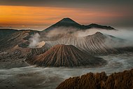
The volcanic complex of Tengger forms a condition where a new caldera of volcano forms inside a larger and more ancient caldera. There are five volcanoes inside the Tengger Caldera: Mount Bromo (2,329 m), Mount Batok (2,470 m), Mount Kursi (2,581 m), Mount Watangan (2,661 m), and Mount Widodaren (2,650 m). Mount Batok is the only peak that is no longer active, and is covered in casuarina (Indonesian: cemara) trees. Mount Widodaren, located beside Mount Batok, contains the cave Widodaren, which is considered sacred by local people.
The five volcanoes within the caldera are surrounded by a vast area of sand called the Tengger Sand Sea, which in turn is surrounded by a steep crater wall of the larger Tengger Caldera with height differences of about 200–600 meters (660–1,970 ft). Other mountains around the Tengger caldera are: Mount Pananjakan (2,770 m), Mount Cemorolawang (2,227 m), Mount Lingker (2,278 m), Mount Pundak Lembu (2,635 m), Mount Jantur (2,705 m), Mount Ider-ider (2,527 m) and Mount Mungal (2,480 m). The peak of Mount Pananjakan is the most popular place to watch the entire volcanic complex of Tengger.[8]
Further south in the national park, there is another volcanic complex called the Semeru Group or Jambangan Group. This area contains the highest peak of Java,
Climate
The climate in Bromo Tengger Semeru is cold, especially in winter from May until September. There is heavy rainfall in summer, while there is little to no precipitation in winter. Nighttime temperatures in winter commonly fall below zero degrees Celsius, with potential for
| Climate data for Podokoyo, Tosari, Bromo Tengger Semeru National Park (elevation 2,338 m or 7,671 ft) | |||||||||||||
|---|---|---|---|---|---|---|---|---|---|---|---|---|---|
| Month | Jan | Feb | Mar | Apr | May | Jun | Jul | Aug | Sep | Oct | Nov | Dec | Year |
| Mean daily maximum °C (°F) | 16.5 (61.7) |
16.7 (62.1) |
16.9 (62.4) |
16.7 (62.1) |
16.7 (62.1) |
16.1 (61.0) |
15.6 (60.1) |
15.8 (60.4) |
16.3 (61.3) |
16.9 (62.4) |
16.7 (62.1) |
16.6 (61.9) |
16.5 (61.6) |
| Daily mean °C (°F) | 12.8 (55.0) |
12.9 (55.2) |
13.2 (55.8) |
12.8 (55.0) |
12.6 (54.7) |
11.9 (53.4) |
11.1 (52.0) |
11.3 (52.3) |
11.7 (53.1) |
12.6 (54.7) |
13.1 (55.6) |
12.9 (55.2) |
12.4 (54.3) |
| Mean daily minimum °C (°F) | 9.2 (48.6) |
9.1 (48.4) |
9.6 (49.3) |
9 (48) |
8.6 (47.5) |
7.8 (46.0) |
6.7 (44.1) |
6.8 (44.2) |
7.2 (45.0) |
8.3 (46.9) |
9.5 (49.1) |
9.2 (48.6) |
8.4 (47.1) |
| Average precipitation mm (inches) | 297 (11.7) |
337 (13.3) |
350 (13.8) |
184 (7.2) |
105 (4.1) |
64 (2.5) |
37 (1.5) |
15 (0.6) |
19 (0.7) |
69 (2.7) |
141 (5.6) |
315 (12.4) |
1,933 (76.1) |
| Source: Climate-Data.org (temp & precip)[9] | |||||||||||||
Ecosystem

According to height and temperature differences, the forests within the area can be classified into three zones:
Sub-montane zone (750 – 1,500 m)
This zone is classified as a tropical rainforest. It can be found in the southern area of Semeru, East Semeru (Burno), and West Semeru (Patok Picis). This zone is dominated with plants of the families
Montane zone (1,500 – 2,440 m)

Plant life is greatly reduced in this area. Most of the species that grow in this area are
The Tengger Sand Sea in Tengger Caldera is a special ecosystem. The area is covered in volcanic sedimentation of sand from Mount Bromo activities. The resulting area is believed to be the only known desert-like area in Indonesia. The Tengger Sand Sea has been protected since 1919.
Subalpine zone (above 2,400 m)
The flora that cover this area are mentinggi gunung (
On Mount Semeru, there is no plant life above the altitude of 3,100 m. This zone is covered in loose sandstones.[10]
Flora and fauna
Some endangered flora are protected in this park, such as
Culture
The area in and around the park is inhabited by the
Gallery
-
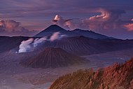 Gunung Bromo sunrise
 -
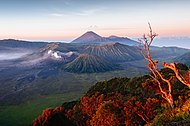 Tengger Caldera at sunrise
 -
-

-


See also
References
- ^ Forestry statistics of Indonesia 2007 Archived July 22, 2011, at the Wayback Machine, retrieved May 20, 2010
- ^ a b c d "Ministry of Forestry: Bromo Tengger Semeru National Park". Archived from the original on March 23, 2010. Retrieved January 3, 2010.
- ^ "Global Volcanism Program: Mount Semeru". Retrieved June 12, 2017.
- ^ "Bromo Volcano (Tengger Caldera)".
- ^ Letter of Statement of the Agrarian Minister No.736/Mentan/X/1982
- ^ "The dark, otherworldy landscapes of Tengger Massif, Indonesia". When on Earth. Retrieved September 10, 2015.
- ^ "Indonesia's mountains of fire". Lonely Planet. June 2, 2011. Retrieved September 10, 2015.
- ^ "Bromo Tengger Semeru National Park". Eastjava Department of Tourism, Art and Culture Service. May 26, 2015. Retrieved January 1, 2010.[permanent dead link]
- ^ "Climate: Podokoyo". Climate-Data.org. Retrieved March 22, 2019.
- ^ a b c d "Biological Conditions". Bromo Tengger Semeru National Park. Eastjava Department of Tourism, Art and Culture Service. Retrieved January 1, 2010.
- ^ "Flora and Fauna". Bromo Tengger Semeru National Park. Eastjava Department of Tourism, Art and Culture Service. Retrieved January 1, 2010.
External links
| International | |
|---|---|
| National | |