
Brunswick, Maine
Brunswick, Maine | |
|---|---|
 Downtown Brunswick, looking north along Maine Street | |
|
Eastern) | |
| ZIP code | 04011 |
| Website | www |
Brunswick is a
History


Settled in 1628 by
The
In 1714, a
The
Principal employers for Brunswick include
National Register of Historic Places
Brunswick has a number of historic districts recognized on the National Register of Historic Places:
- Androscoggin Swinging Bridge
- Henry Boody House
- Brunswick Commercial Historic District
- Parker Cleaveland House
- Crystal Spring Farm
- John Dunlap House
- Federal Street Historic District
- First Parish Church
- Lincoln Street Historic District
- Massachusetts Hall, Bowdoin College
- Pennellville Historic District
- Richardson House
- St. Paul's Episcopal Church
- Harriet Beecher Stowe House
- Whittier Field
In popular culture
The book Uncle Tom's Cabin was written by Harriet Beecher Stowe while she was living in Brunswick, during the time that her husband was a professor at Bowdoin. She got a key vision for the book in the First Parish Church.[11]
A scene in the 1993 movie The Man Without a Face was filmed in the town.[10]
Geography
According to the United States Census Bureau, the town has a total area of 54.34 square miles (140.74 km2), of which 46.73 square miles (121.03 km2) is land and 7.61 square miles (19.71 km2) is water.[1] Brunswick is located at the north end of Casco Bay, as well as the head of tide and head of navigation on the Androscoggin River.
Climate
| Climate data for Brunswick, Maine | |||||||||||||
|---|---|---|---|---|---|---|---|---|---|---|---|---|---|
| Month | Jan | Feb | Mar | Apr | May | Jun | Jul | Aug | Sep | Oct | Nov | Dec | Year |
| Record high °F (°C) | 61 (16) |
59 (15) |
73 (23) |
84 (29) |
94 (34) |
100 (38) |
98 (37) |
104 (40) |
95 (35) |
85 (29) |
74 (23) |
68 (20) |
104 (40) |
| Mean daily maximum °F (°C) | 31 (−1) |
34 (1) |
43 (6) |
54 (12) |
65 (18) |
74 (23) |
79 (26) |
78 (26) |
70 (21) |
59 (15) |
47 (8) |
36 (2) |
56 (13) |
| Mean daily minimum °F (°C) | 10 (−12) |
14 (−10) |
23 (−5) |
33 (1) |
44 (7) |
53 (12) |
59 (15) |
58 (14) |
50 (10) |
38 (3) |
30 (−1) |
18 (−8) |
36 (2) |
| Record low °F (°C) | −49 (−45) |
−25 (−32) |
−10 (−23) |
13 (−11) |
27 (−3) |
34 (1) |
37 (3) |
37 (3) |
28 (−2) |
18 (−8) |
1 (−17) |
−21 (−29) |
−49 (−45) |
| Average precipitation inches (mm) | 3.72 (94) |
3.55 (90) |
4.37 (111) |
4.74 (120) |
4.52 (115) |
4.17 (106) |
4.00 (102) |
3.30 (84) |
4.23 (107) |
4.94 (125) |
5.62 (143) |
4.07 (103) |
51.23 (1,300) |
| Source: weather.com[12] | |||||||||||||
Neighboring cities and towns
Places adjacent to Brunswick, Maine | |
|---|---|
Demographics
| Census | Pop. | Note | %± |
|---|---|---|---|
| 1790 | 1,357 | — | |
| 1800 | 1,809 | 33.3% | |
| 1810 | 2,682 | 48.3% | |
| 1820 | 2,931 | 9.3% | |
| 1830 | 3,547 | 21.0% | |
| 1840 | 4,259 | 20.1% | |
| 1850 | 4,977 | 16.9% | |
| 1860 | 4,723 | −5.1% | |
| 1870 | 4,687 | −0.8% | |
| 1880 | 5,384 | 14.9% | |
| 1890 | 6,012 | 11.7% | |
| 1900 | 6,806 | 13.2% | |
| 1910 | 6,621 | −2.7% | |
| 1920 | 7,261 | 9.7% | |
| 1930 | 7,604 | 4.7% | |
| 1940 | 8,658 | 13.9% | |
| 1950 | 10,996 | 27.0% | |
| 1960 | 15,797 | 43.7% | |
| 1970 | 16,195 | 2.5% | |
| 1980 | 17,366 | 7.2% | |
| 1990 | 20,906 | 20.4% | |
| 2000 | 21,172 | 1.3% | |
| 2010 | 20,278 | −4.2% | |
| 2020 | 21,756 | 7.3% | |
| [13][14][15] | |||
As of 2000, the median income for a household in the town was $40,402; and the median income for a family was $49,088. Males had a median income of $32,141 versus $24,927 for females. The
2010 census
As of the
There were 8,469 households, of which 25.7% had children under the age of 18 living with them; 44.7% were married couples living together; 9.7% had a female householder with no husband present; 3.3% had a male householder with no wife present; and 42.3% were non-families. 35.1% of all households were made up of individuals, and 16.5% had someone living alone who was 65 years of age or older. The average household size was 2.19 and the average family size was 2.83.
The median age in the town was 41.4 years. 19.2% of residents were under the age of 18; 14.1% were between the ages of 18 and 24; 20.8% were from 25 to 44; 27.6% were from 45 to 64; and 18.2% were 65 years of age or older. The gender makeup of the town was 47.1% male and 52.9% female.
Education

The Brunswick School Department operates the town's public schools, including:
- Brunswick High School
- Brunswick Junior High School
- Kate Furbish Elementary School
- Harriet Beecher Stowe Elementary School
- REAL School
- Region 10 Technical High School
Other local educational institutions include:
- Children's School of Arts & Science
- Saint John's Catholic School
- Bowdoin College
- Southern Maine Community College Midcoast Campus
The Growstown School, on Woodside Road, is the last remaining of the town's formerly twenty-six one-room schoolhouses.
Sites of interest


- Androscoggin Pedestrian Swinging Bridge
- Bowdoin College Museum of Art
- Pejepscot Historical Society
- Pejepscot Museum
- Joshua L. Chamberlain Museum
- Skolfield-Whittier House
Infrastructure
Transportation
The town is served by Interstate 295, U.S. Routes 1 and 201, and Maine State Route 24, Maine State Route 123 and Maine State Route 196.

Amtrak's Downeaster train service terminates at Brunswick Maine Street Station and connects the town to the Portland Transportation Center and Boston's North Station.
Greater Portland Metro provides several trips a day between the Portland Transportation Center and Brunswick Maine Street Station with its Metro Breez bus service. A local bus service is provided by Brunswick Link.
Notable people
- John Stevens Cabot Abbott, clergyman and author
- Daniel Ankeles, state legislator[16]
- Poppy Arford, state legislator
- Dale Arnold, sportscaster, co-host of the WEEI-FM Dale & Holley (with Keefe) Show and the Boston Bruins pre and postgame shows on NESN; resided in Brunswick
- Austin Cary, forester
- Fanny Chamberlain, wife of Joshua Chamberlain
- governor of Maine
- Walter Christie, author
- Robert P. T. Coffin, poet
- Alexander Cornell du Houx, state legislator
- Scott Cowger, state legislator
- Elizabeth W. Crandall, environmental and women's rights activist
- Dale Glaciernamesake
- governor of Maine
- Charles Carroll Everett, theologian
- Stanley Gerzofsky, state legislator
- John Gould, reporter, columnist
- Frederic Aldin Hall, professor, school chancellor
- Joshua Herrick, congressman
- Graeme K., musician
- governor of Maine
- Lady Lamb, musician
- Henry Wadsworth Longfellow, poet
- Cynthia Lord, children's author
- Stump Merrill, baseball player
- Karen Mills, Administrator of Small Business Administration, cabinet-level position
- Ralph Mims, basketball player
- Benjamin Orr, congressman
- Alpheus Spring Packard, professor
- George Palmer Putnam, publisher
- Luke Rathborne, musician
- John Rankin Rogers, third Governor of the state of Washington
- Mark Rogers, pitcher for the Milwaukee Brewers
- Patricia E. Ryan, human rights advocate and women's rights lobbyist
- Arthur A. Small, Iowa state legislator and lawyer
- Harriet Beecher Stowe, abolitionist, author
- Brigadier Samuel Thompson, Revolutionary War soldier
- Grant Tremblay, astrophysicist
- George J. Varney, author and historian
- Dan Walters, baseball player and police officer
- Robert Zildjian, founder of Sabian cymbals
References
- ^ a b "US Gazetteer files 2010". United States Census Bureau. Archived from the original on December 20, 2012. Retrieved December 16, 2012.
- ^ a b "U.S. Census website". United States Census Bureau. Retrieved December 16, 2012.
- ^ "Population, Census, April 1, 2020 Brunswick, ME". U.S. Census Bureau QuickFacts.
- ^ Drake, The Border Wars of New England. p. 66
- ^ Drake, p. 67
- ^ Drake, p. 69
- ^ a b Coolidge, Austin J.; John B. Mansfield (1859). A History and Description of New England. Boston, Massachusetts: A.J. Coolidge. pp. 75–77.
coolidge mansfield history description new england 1859.
- ^ Varney, George J. (1886), Gazetteer of the state of Maine. Brunswick, Boston: Russell, archived from the original on February 1, 2013
- ^ "Historical Sketch of Brunswick, Maine (1889)". rays-place.com. Archived from the original on February 1, 2013. Retrieved May 1, 2018.
- ^ a b Southern Midcoast Maine Chamber of Commerce Archived November 26, 2010, at the Wayback Machine
- ^ Pope, Sarah Dillard. "Aboard the Underground Railroad-- Harriet Beecher Stowe House--Maine". www.nps.gov. Archived from the original on September 2, 2013. Retrieved May 1, 2018.
- Weather.com. The Weather Channel. Archivedfrom the original on June 5, 2008. Retrieved August 15, 2013.
- ^ "Population of Counties by Decennial Census: 1900 to 1990". Archived from the original on October 12, 2012. Retrieved January 10, 2013.
- ^ "U.S. Census Bureau". Archived from the original on May 20, 2011. Retrieved November 3, 2015.
- ^ "University of Virginia Library". mapserver.lib.virginia.edu. Archived from the original on August 11, 2012. Retrieved May 1, 2018.
- ^ "Representative Daniel Ankeles". legislature.maine.gov. Retrieved February 13, 2024.
Further reading
- History of the Town Commons, Brunswick, Maine
- History of Brunswick, Topsham, and Harpswell, Maine Including Ancient Pejebscot. By George Augustus Wheeler and Henry Warren Wheeler. Published 1878. Full image at books.google.
External links
- Town of Brunswick official website
- Curtis Memorial Library
- New Meadows Watershed Partnership
- Brunswick and Topsham Water District
 Brunswick travel guide from Wikivoyage
Gallery
-
 Brunswick Falls c. 1912
 -
 Class of 1903 Gates at Bowdoin c. 1920
 -
 Massachusetts Hall at Bowdoin in 1907
 -
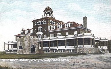 Merrymeeting Park Casino c. 1905
 -
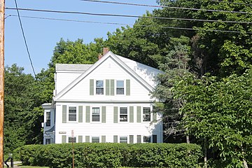 One of the middle-class New England homes in Brunswick
 -
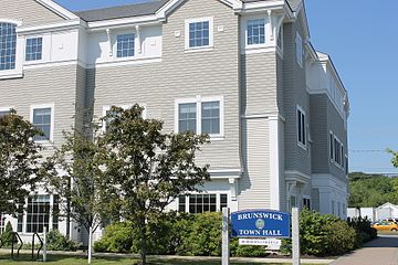 Brunswick Town Hall
 -
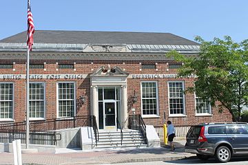 U.S. Post Office in Brunswick
 -
 An example ofGothic Revival architecture, the First Parish United Church of Christ at 207 Maine Street in Brunswick (founded 1845), was added in 1969 to the National Register of Historic Places.


Municipalities and communities of Cumberland County, Maine, United States | ||
|---|---|---|
| Cities |  | |
| Towns | ||
| CDPs |
| |
| Other villages | ||
| ||
Augusta (capital) | |
| Topics | |
| Society |
|
| Regions |
|
| Counties | |
Cities | |
Largest towns | |
| International | |
|---|---|
| National | |
| Geographic | |
| Other | |