Brynderwyn Range
(Redirected from
Brynderwyn Hills
)
| Brynderwyn Range | |
|---|---|
| Brynderwyn Hills | |
The eastern end of the Brynderwyn Range as seen from Mangawhai Heads (October 2010) | |
| Highest point | |
| Elevation | 430 m (1,410 ft)[1][2] |
| Coordinates | 36°04′27″S 174°30′09″E / 36.0742°S 174.5024°E |
| Naming | |
| Native name | Piroa (Māori)[3] |
| Geography | |
| Geology | |
| Mountain type | Mountain range |
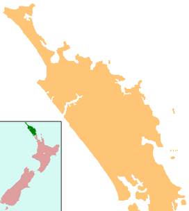
The Brynderwyn Range or Brynderwyn Hills is a ridge extending east–west across the
SH12. There are different walks of up to 10 km giving views of the Whangārei Heads, Bream Bay and out to sea.[4]
The hills were the site of New Zealand's worst road accident.[5] On 7 February 1963, a bus crashed after losing control of its brakes while nearing the top of the southern descent, killing 15 of the 35 people on board.[6] In July 2014 the presumed remains of a 20-year missing Northland man were found there by forestry workers on a steep hillside.[7]
References
- ^ Land Information New Zealand (May 2020). Topo50 map AY30 - Maungaturoto (Map). Retrieved 10 October 2020.
- ^ Land Information New Zealand (May 2020). Topo50 map AY31 - Mangawhai (Map). Retrieved 10 October 2020.
- ^ Piroa-Brynderwyns Landcare Five Year Plan – 2018–2023 (PDF) (Booklet). Piroa-Brynderwyns Landcare. August 2018. Archived (PDF) from the original on 28 January 2020. Retrieved 10 October 2020.
- ^ "Whangarei area: Brynderwyn Hills Walk". Department of Conservation (New Zealand). May 2014. Retrieved 25 July 2014.
- ^ Brynderwyn tragedy: The nightmare never fades. The New Zealand Herald.
- ^ New Zealand Disasters – Bus Accident: The Brynderwyns. Christchurch City Libraries website.
- Northern Advocate. Retrieved 25 July 2014.

