
Bugaksan
| Bugaksan | |
|---|---|
 Bugaksan overlooking the former royal palace Gyeongbokgung (2008) | |
| Highest point | |
| Elevation | 342 m (1,122 ft) |
| Naming | |
| Etymology | North mountain |
| Geography | |
| Country | South Korea |
| City | Seoul |
 | |
| Korean name | |
| Hangul | 북악산 |
| Hanja | |
| Revised Romanization | Bugaksan |
| McCune–Reischauer | Pugaksan |
| Alternate name | |
| Hangul | 백악산 |
| Hanja | 白岳山 |
| Revised Romanization | Baegaksan |
| McCune–Reischauer | Paegaksan |
Bugaksan
The mountain has historically gone by a number of other names, including Baegaksan (백악산).
Names
Until the Joseon period, the mountain went by a variety of names, including "Baegaksan", "Myeonaksan" (면악산; 面岳山), and "Gonggeuksan" (공극산; 拱極山). However, "Baegaksan" was the most popular name during the Joseon period.[2]
The name "Bugaksan", meaning "north mountain",[4] became popular just after the Japanese colonial period. Some government offices have made efforts to return to using the "Baegaksan" name, in order to strengthen modern South Korea's ties to the pre-Japanese past.[2]
Description
The mountain is part of a range of mountains connected to the south of Bukhansan, the highest mountain in Seoul.[2]
There are 208 species of plants on the mountain, including 81 species of trees.[2]
The Cheonggyecheon stream that flows through Seoul originates from the mountain. In November 2005, the Jongno District government investigated the source of the river, and found that it was a mineral water spring about 150 metres (490 ft) from a statue of police officer Choi Gyu-sik.[2]
History
Beginning in the Joseon period, the mountain was a popular spot for the aristocracy to construct villas.[2]
After the
The mountain was designated an area of secnic beauty in 2009 by the Cultural Heritage Administration.[2]
Gallery
-
 Late 19th century photograph of Bugaksan and Gwanghwamun
 -
 1915 painting of Bugaksan by An Jung-sik
 -
 1953 view of the mountain, fromJapanese General Government Buildingcan be seen standing where Gyeongbokgung stood before
 -
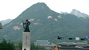 Statue of Admiral Yi Sun-sin and the mountain. The Blue House and the Statue of King Sejong can also be seen in the bottom. (2011)
 -
 View from the mountain looking north (2016)


.jpg)
See also
Notes
References
- ^ a b "Hanyangdoseong of Bukaksan Returns to the Public". Korea Cultural Heritage Foundation. Retrieved 2023-08-17.
- ^ a b c d e f g h i j 김, 주환. "북악산(北岳山)" [Bugaksan]. Encyclopedia of Korean Culture (in Korean). Retrieved 2023-08-17.
- ^ a b "북악산" (in Korean). Doosan Encyclopedia. Retrieved 29 September 2014.
- ^ "北岳山". Naver Hanja Dictionary (in Korean). Retrieved 2023-08-17.
- ^ "Bugaksan Mountain". english.visitseoul.net. Retrieved 2023-08-17.