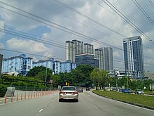
Bukit Jalil
This article needs additional citations for verification. (February 2014) |
Bukit Jalil
بوکيت جليل 武吉加里爾 புக்கிட் ஜலீல் | ||
|---|---|---|
Fire | Bukit Jalil | |

Bukit Jalil is an affluent suburb in
National Sports Complex was developed for the 1998 Commonwealth Games. The suburb was used as a filming location for the 1999 movie Entrapment, although the sign was changed to that of Pudu.[1]
Transportation

Bukit Jalil is strategically connected to other parts of
Sri Petaling Line SP17 Bukit Jalil LRT station and SP18 Sri Petaling LRT station, SP19 Awan Besar LRT station
.
Education
Bukit Jalil consists of several educational institutions such as
Asia Pacific Institute of Information Technology, Asia Pacific University of Technology & Innovation(APU) and Bukit Jalil National Secondary School
.
Malls
- Pavilion Bukit Jalil
- Aurora Place Bukit Jalil
Residential
There are many high-rise apartments and high-end condominiums situated around Bukit Jalil.
- Arena Green
- Bukit OUG Condominium
- Casa Green
- Covillea Residence
- Denai Sutera
- Greenfields
- Green Avenue
- Impiana Sky
- Jalil Damai
- Kiara Residence 1&2
- KM1 East and West
- Lanai Residence
- LTAT Apartments
- Paraiso Residence
- Parkhill Residence
- PPA1M Bukit Jalil
- Residensi Bukit Jalil
- Residensi Bintang
- Residensi Jalilmas
- Savanna Residence 1&2
- Skyluxe Residence
- The Como
- The Havre
- The Link 2
- The Park Sky Residence (Pavilion)
- The Park 2 (Pavilion)
- The Rainz
- The Treez
- The Tropika
- Twin Arkz
- Vista Commonwealth
- Z Residence

Landed properties in Bukit Jalil are Alam Sutera, Bukit Jalil Golf & Country Resort, Esplanade, Jalil Sutera and Sri Jalil.
See also
Wikimedia Commons has media related to Bukit Jalil.
- Sri Petaling LRT Station
- Bukit Jalil LRT Station
- Awan Besar LRT Station
