
Cahokia, Illinois
Cahokia | |
|---|---|
618 | |
| FIPS code | 17-10370 |
| GNIS feature ID | 426287[1] |
| Wikimedia Commons | Cahokia, Illinois |
| Website | www |
Cahokia is a settlement and former village in
The name refers to one of the clans of the historic
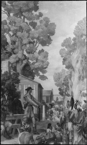
French Canadian colonists founded Cahokia village in 1696 as a Catholic mission. The historic
History
The Cahokia Native Americans of the Illini did not coalesce as a tribe and live in the Illinois area until nearly the time of French contact 300 years ago. Father Pinet founded a
During the next 100 years, Cahokia became one of the largest French colonial towns in the
Cahokia declined after the French lost the
The
In 1778, during the

After Congress passed the
In the late 1950s, Cahokia annexed some population and territory, increasing its population by more than 15,000 in 1960.
Geography
Cahokia was located at 38°33′43″N 90°10′22″W / 38.561901°N 90.172878°W.[4]
According to the 2010 census, Cahokia had a total area of 9.9 square miles (25.64 km2), of which 9.4 square miles (24.35 km2) (or 94.95%) is land and 0.5 square miles (1.29 km2) (or 5.05%) is water.[5]
Climate
| Climate data for Cahokia, Illinois, 1991–2020 normals, extremes 1997–present | |||||||||||||
|---|---|---|---|---|---|---|---|---|---|---|---|---|---|
| Month | Jan | Feb | Mar | Apr | May | Jun | Jul | Aug | Sep | Oct | Nov | Dec | Year |
| Record high °F (°C) | 72 (22) |
81 (27) |
86 (30) |
92 (33) |
95 (35) |
107 (42) |
107 (42) |
105 (41) |
102 (39) |
94 (34) |
85 (29) |
75 (24) |
107 (42) |
| Mean maximum °F (°C) | 63.5 (17.5) |
69.9 (21.1) |
79.4 (26.3) |
86.4 (30.2) |
90.4 (32.4) |
95.9 (35.5) |
97.8 (36.6) |
97.5 (36.4) |
93.9 (34.4) |
87.4 (30.8) |
75.5 (24.2) |
66.6 (19.2) |
99.7 (37.6) |
| Mean daily maximum °F (°C) | 40.7 (4.8) |
46.0 (7.8) |
56.1 (13.4) |
67.5 (19.7) |
76.1 (24.5) |
84.8 (29.3) |
88.5 (31.4) |
87.3 (30.7) |
80.3 (26.8) |
69.5 (20.8) |
56.2 (13.4) |
45.1 (7.3) |
66.5 (19.2) |
| Daily mean °F (°C) | 31.4 (−0.3) |
35.8 (2.1) |
45.4 (7.4) |
56.5 (13.6) |
66.0 (18.9) |
74.8 (23.8) |
78.7 (25.9) |
77.0 (25.0) |
69.5 (20.8) |
57.7 (14.3) |
45.7 (7.6) |
35.8 (2.1) |
56.2 (13.4) |
| Mean daily minimum °F (°C) | 22.0 (−5.6) |
25.6 (−3.6) |
34.7 (1.5) |
45.4 (7.4) |
56.0 (13.3) |
64.9 (18.3) |
68.9 (20.5) |
66.7 (19.3) |
58.6 (14.8) |
46.0 (7.8) |
35.3 (1.8) |
26.6 (−3.0) |
45.9 (7.7) |
| Mean minimum °F (°C) | 2.9 (−16.2) |
8.1 (−13.3) |
17.0 (−8.3) |
30.3 (−0.9) |
39.4 (4.1) |
52.0 (11.1) |
57.9 (14.4) |
53.9 (12.2) |
44.3 (6.8) |
28.7 (−1.8) |
20.4 (−6.4) |
10.5 (−11.9) |
0.5 (−17.5) |
| Record low °F (°C) | −14 (−26) |
−7 (−22) |
4 (−16) |
24 (−4) |
33 (1) |
45 (7) |
50 (10) |
47 (8) |
35 (2) |
22 (−6) |
11 (−12) |
−5 (−21) |
−14 (−26) |
| Average precipitation inches (mm) | 2.67 (68) |
2.26 (57) |
3.55 (90) |
4.63 (118) |
4.80 (122) |
4.30 (109) |
5.02 (128) |
3.09 (78) |
3.35 (85) |
3.04 (77) |
3.33 (85) |
2.75 (70) |
42.79 (1,087) |
| Average snowfall inches (cm) | 4.9 (12) |
3.7 (9.4) |
1.2 (3.0) |
0.3 (0.76) |
0.0 (0.0) |
0.0 (0.0) |
0.0 (0.0) |
0.0 (0.0) |
0.0 (0.0) |
0.0 (0.0) |
0.8 (2.0) |
2.9 (7.4) |
13.8 (34.56) |
| Average precipitation days (≥ 0.01 in) | 9.0 | 7.9 | 10.4 | 11.6 | 12.2 | 10.2 | 8.4 | 7.6 | 7.2 | 8.2 | 8.3 | 9.5 | 110.5 |
| Average snowy days (≥ 0.1 in) | 2.8 | 2.4 | 1.0 | 0.2 | 0.0 | 0.0 | 0.0 | 0.0 | 0.0 | 0.0 | 0.3 | 2.1 | 8.8 |
| Source 1: NOAA[6] | |||||||||||||
| Source 2: National Weather Service (mean maxima/minima 2006–2020)[7] | |||||||||||||
Demographics
| Census | Pop. | Note | %± |
|---|---|---|---|
| 1880 | 211 | — | |
| 1930 | 286 | — | |
| 1940 | 465 | 62.6% | |
| 1950 | 794 | 70.8% | |
| 1960 | 15,829 | 1,893.6% | |
| 1970 | 20,649 | 30.5% | |
| 1980 | 18,904 | −8.5% | |
| 1990 | 17,550 | −7.2% | |
| 2000 | 16,391 | −6.6% | |
| 2010 | 15,241 | −7.0% | |
| 2020 | 12,096 | −20.6% | |
| U.S. Decennial Census[8] | |||
2020 census
| Race / Ethnicity (NH = Non-Hispanic) | Pop 2010[9] | Pop 2020[10] | % 2010 | % 2020 |
|---|---|---|---|---|
White alone (NH)
|
5,126 | 2,689 | 33.63% | 22.23% |
Black or African American alone (NH)
|
9,455 | 8,554 | 62.04% | 70.72% |
Alaska Native alone (NH)
|
30 | 43 | 0.20% | 0.36% |
| Asian alone (NH) | 29 | 10 | 0.19% | 0.08% |
| Pacific Islander alone (NH) | 2 | 6 | 0.01% | 0.05% |
| Some Other Race alone (NH) | 29 | 52 | 0.19% | 0.43% |
| Mixed Race/Multi-Racial (NH) | 272 | 457 | 1.78% | 3.78% |
| Hispanic or Latino (any race) | 298 | 285 | 1.96% | 2.36% |
| Total | 15,241 | 12,096 | 100.00% | 100.00% |
2000 census
As of the
There were 5,693 households, out of which 41.2% had children under the age of 18 living with them, 43.2% were married couples living together, 25.7% had a female householder with no husband present, and 25.3% were non-families. 20.9% of all households were made up of individuals, and 8.6% had someone living alone who was 65 years of age or older. The average household size was 2.84 and the average family size was 3.27.
In 2010, the population dropped to 15,241, with 61.30% being African American and 34.5% of the population being white alone.[13]
In the village, the population was spread out, with 33.4% under the age of 18, 8.7% from 18 to 24, 29.4% from 25 to 44, 16.9% from 45 to 64, and 11.6% who were 65 years of age or older. The median age was 31 years. For every 100 females, there were 88.7 males. For every 100 females age 18 and over, there were 82.5 males.
The median income for a household in the village was $31,001, and the median income for a family was $35,582. Males had a median income of $31,806 versus $22,429 for females. The
Transportation
Cahokia is home to the St. Louis Downtown Airport, a general aviation facility.
Metro operates the #2 bus route to
Education
- Cahokia Unit School District 187 operates public schools.
Notable people
- Well Hungarians – country and rock band
- Terron Armstead - NFL player
See also
- Battle of St. Louis (1780)
References
- ^ a b c U.S. Geological Survey Geographic Names Information System: Cahokia, Illinois
- ^ "2019 U.S. Gazetteer Files". United States Census Bureau. Retrieved July 14, 2020.
- ^ "3 Metro East cities officially merge to create Cahokia Heights". KMOV. May 6, 2021. Retrieved May 6, 2021.
- ^ "US Gazetteer files: 2010, 2000, and 1990". United States Census Bureau. February 12, 2011. Retrieved April 23, 2011.
- ^ "G001 - Geographic Identifiers - 2010 Census Summary File 1". United States Census Bureau. Archived from the original on February 13, 2020. Retrieved August 2, 2015.
- ^ "U.S. Climate Normals Quick Access – Station: Cahokia, IL". National Oceanic and Atmospheric Administration. Retrieved February 25, 2023.
- ^ "NOAA Online Weather Data – NWS St. Louis". National Weather Service. Retrieved February 25, 2023.
- ^ "Census of Population and Housing". Census.gov. Retrieved June 4, 2015.
- ^ "P2 Hispanic or Latino, and Not Hispanic or Latino by Race – 2010: DEC Redistricting Data (PL 94-171) – Cahokia village, Illinois". United States Census Bureau.
- ^ "P2 Hispanic or Latino, and Not Hispanic or Latino by Race – 2020: DEC Redistricting Data (PL 94-171) – Cahokia village, Illinois". United States Census Bureau.
- ^ "U.S. Census website". United States Census Bureau. Retrieved January 31, 2008.
- ^ "Index of /census_2000/datasets/Summary_File_4/Illinois". www2.census.gov.
- ^ "U.S. Census Bureau QuickFacts: Cahokia village, Illinois". Census.gov. Retrieved July 20, 2022.
Further reading
- Reed, Denita. Cahokia (Images of America). ISBN 0738589977, 9780738589978.
| Counties |  | |
|---|---|---|
| Major cities (25,000+) | ||
| Cities (5,000-25,000) | ||
| Communities (1,000-5,000) |
| |
| Transit systems | ||
| Amtrak stations |
| |
| Interstates | ||
| Airports | ||
| Colleges | ||
| Sports teams |
| |
 | ||||
Villages | ||||
| Townships | ||||
| CDPs | ||||
| Other unincorporated communities | ||||
| Footnotes | ‡This populated place also has portions in an adjacent county or counties | |||
| ||||
| Topics |  | |
|---|---|---|
| Central city | ||
| Largest cities (over 50,000 in 2020) | ||
| Medium-sized cities (over 20,000 in 2020) | ||
| Largest towns and villages (over 10,000 in 2020) |
| |
| Missouri counties | ||
| Illinois counties | ||
| Subregions |
| |
| Counties |  | |
|---|---|---|
| Mid-sized cities (25,000+) | ||
| Small cities (10,000-25,000) | ||
| Small cities (5,000-10,000) | ||
| Transit systems | ||
| Amtrak stations | ||
| Interstates | ||
| Airports/military bases |
| |
| Universities | ||
| Colleges | ||
| Sports teams based in Southern Illinois | ||
| International | |
|---|---|
| National | |