
Cairngorms
| Cairngorms | |
|---|---|
IUCN category IV (habitat/species management area) | |
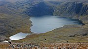
 Cairn Gorm view over Coire an t-Sneachda, a glacial cirque | |
 Location within Scotland (dot shows approximate centre of the central plateau) | |
| Location | Highland, Aberdeenshire and Moray, Scotland |
| Nearest city | Inverness, Aberdeen |
| Coordinates | 57°06′N 3°41′W / 57.10°N 03.68°W |
| Area | 292 km2 (113 sq mi)[1] |
| Established | 1987[1] |
| Governing body | NatureScot |
The Cairngorms (
The Cairngorms consists of high plateaux at about 1,000–1,200 m (3,300–3,900 ft) above sea level, above which domed summits (the eroded stumps of once much higher mountains
There are no glaciers, but snow can fall in any month of the year, and
The range lies in the Scottish council areas of Aberdeenshire, Moray and Highland,[12] and within the counties of Aberdeenshire, Inverness-shire and Banffshire.
Etymology
The original Gaelic name for the range is Am Monadh Ruadh (the red hills), distinguishing them from Am Monadh Liath (the grey hills), which lie to the west of the River Spey:
If you look from Aviemore on a clear evening, the granite screes of Lairig Ghru and Braeriach do glow a warm red in the sun. The name Am Monadh Ruadh still lives among the oldest folk of Strath Spey, but long ago, outsiders had replaced it with 'the Cairngorms', on maps and in guide books.
— Watson[13]
The English language name for the range is Cairngorms, and is derived from Cairn Gorm, which is prominent in the view of the mountains from Speyside. The earliest reference to this name appears to be from a Colonel T. Thornton, who visited the area in about 1786:[13][14]
The use of the term "Cairngorms" as applied to the group must have become well established early in the nineteenth century, for we find it in Col Thornton's Sporting Tour (1804), where there is a reference to "Aurora peeping over the immense Cairngorms."
— Alexander[14] (p21)
Cairn Gorm is generally translated as Blue Cairn, although the Gaelic gorm is also used as an adjective and verb, meaning green or greening and is often seen in connection with growing grass.[15] Thus, there is a contradiction or confusion, because the original Scottish Gaelic name of the mountains translates to English as the "red hills" whilst their English name is the "blue hills" or the "green hills".
Geography

The Cairngorms consist of three large elevated plateaux adorned with low, rounded glacial mountains, and divided by the passes of the
The approximate southern boundary of the Cairngorm range is generally reckoned to run from slightly east of
The Cairngorms feature the highest, coldest and snowiest
- Ben Macdui(1,309 m (4,295 ft))
- Braeriach (1,296 m (4,252 ft))
- Cairn Toul (1,293 m (4,242 ft))
- Sgor an Lochain Uaine(1,258 m (4,127 ft))
- Cairn Gorm (1,245 m (4,085 ft))
There are no public roads through the Cairngorms, and all the public roads in the general area either skirt the Cairngorms or stop short, providing access to them only. From the south and south-east, motorised access ends at
Climate
In terms of height, remoteness and the severe and changeable weather, the Cairngorms are the most arduous area in the United Kingdom.[20] The plateau area has a Tundra climate (Köppen ET),[21] and the shattered terrain is more like the high ground in high-arctic Canada or northern Norway than what is often observed in the European Alps or Rockies.[22] The weather often deteriorates rapidly with altitude so that, when there are moderate conditions 150 m (490 ft) below the plateau, the top can be stormy or misty, and there can be icy or powdery snow. Even when no snow is falling, the wind can whip up lying snow to produce white-out conditions for a few metres above the surface, and snowdrifts can build up rapidly in sheltered places. Gravel can be blown through the air, and walking can be impossible.[23][24]
When a gale is accompanied by thick storms of ground drift, or worse, by heavy falling blizzards plus ground drift, or worse still by mist as well, conditions can be extremely serious on the plateau, making it suffocating and difficult to breathe, hard to open your eyes, impossible to see anything beyond your own feet, and unable to communicate with your party except one at a time by cupping an ear and shouting into it.
The lowest recorded temperature in the
Cairn Gorm gets 320 cm (130 in) of snow annually according to snowforecast.com.
| Climate data for Cairn Gorm Summit, Elevation: 1,245 m (4,085 ft), 1991–2020 | |||||||||||||
|---|---|---|---|---|---|---|---|---|---|---|---|---|---|
| Month | Jan | Feb | Mar | Apr | May | Jun | Jul | Aug | Sep | Oct | Nov | Dec | Year |
| Mean daily maximum °C (°F) | −1.0 (30.2) |
−1.0 (30.2) |
−0.1 (31.8) |
2.0 (35.6) |
5.2 (41.4) |
7.4 (45.3) |
9.6 (49.3) |
9.4 (48.9) |
7.5 (45.5) |
4.0 (39.2) |
1.3 (34.3) |
−0.3 (31.5) |
3.7 (38.6) |
| Daily mean °C (°F) | −3.1 (26.4) |
−3.2 (26.2) |
−2.3 (27.9) |
−0.4 (31.3) |
2.4 (36.3) |
4.8 (40.6) |
7.1 (44.8) |
6.9 (44.4) |
5.1 (41.2) |
1.8 (35.2) |
−0.9 (30.4) |
−2.6 (27.3) |
1.3 (34.3) |
| Mean daily minimum °C (°F) | −5.2 (22.6) |
−5.4 (22.3) |
−4.7 (23.5) |
−2.8 (27.0) |
−0.4 (31.3) |
2.2 (36.0) |
4.5 (40.1) |
4.4 (39.9) |
2.6 (36.7) |
−0.4 (31.3) |
−3.0 (26.6) |
−4.8 (23.4) |
−1.1 (30.1) |
| Average snowfall cm (inches) | 57 (22) |
62 (24) |
49 (19) |
43 (17) |
17 (6.7) |
3 (1.2) |
trace | 0 (0) |
trace | 9 (3.5) |
36 (14) |
47 (19) |
323 (126.4) |
| Source 1: Met Office[30] | |||||||||||||
| Source 2: snowforecast.com [31] | |||||||||||||
Snow patches

The Cairngorms hold some of the longest-lying snow patches in Scotland:
- On Ben Macdui, snow has been known to persist at a few locations from one winter to the next.[32]
- Lying at the north-eastern shoulder of Cairn Gorm is Ciste Mhearad. This hollow contains a patch which, hitherto, was known to persist through many years, but has not done so since 2000.[32] Observations in 2007 and 2008 revealed that September was the month when final melting occurred for this patch.[33] It sits at an altitude of 1,095 m (3,593 ft) and is located at approximately grid reference NJ011046.
- Braeriach's Garbh Choire Mòr is the location of Scotland's most persistent snow beds. Snow has been absent from this corrie just five times in the last century: 1933, 1959, 1996, 2003 and 2006.[34] Sitting at an altitude of about 1140 m, these patches are located around grid reference NN940980; the two most long-lasting patches are known as "the Pinnacles" and "the Sphinx" after the rock climbs lying above them.[35] It has been claimed[by whom?] that Garbh Choire Mòr (as well as Coire an Lochain in the northern corries) may have contained a glacier as recently as the 19th century.[36][37]
In 1994, the Cairngorms and surrounding mountains of north-east Scotland had 55 surviving patches, an exceptional number.[32]
Geology
The Cairngorms were formed 40 million years before the last
Nature and conservation

The Cairngorms provide a unique
The surrounding areas feature an
As well being included as part of the Cairngorms National Park the Cairngorm Mountains are designated as a national scenic area,[43] one of 40 such areas in Scotland.[44] Apart from a small area around the Cairngorm Ski Area, the whole of the mountain area is protected as both a Special Area of Conservation and a Special Protection Area, thus forming part of the Natura 2000 network of protected sites.[45] The Cairngorms are classified as a Category IV protected area by the International Union for Conservation of Nature.[46]
The Cairngorms were declared a national nature reserve (NNR) in 1954, being the largest NNR in Britain. In 2006 Scottish Natural Heritage (SNH) reviewed the Cairngorms NNR, and it was decided that the reserve should be broken up into separate, smaller reserves that reflected existing management units.[47] There now are four NNRs within the core mountain area of the Cairngorms.[45] Mar Lodge Estate, which covers the south side of the plateau and the watershed of the upper Dee has been classified as a national nature reserve since May 2017.[48] The Abernethy Forest National Nature Reserve covers a stretch of land from the plateau down to Loch Garten on the north side of the range, and Glenmore Forest Park, covering a remnant of the Caledonian Forest surrounding Loch Morlich, is also designated as a national nature reserve.[45] The Invereshie and Inshriach National Nature Reserve lies on the western flanks of the range, and extends to the summit of Sgòr Gaoith.[49]
Threats to the ecosystem
The Cairngorms represents an unusually cold area of mountains in a maritime climate at 57 degrees north. The climate is projected to warm—and precipitation patterns to change—under present climate change models. This is an over-riding concern for the long-term conservation of this area. Ptarmigan has been considered as an indicator species for this process, although the natural population cycles of this bird do not seem to have been disrupted as yet.[citation needed]
Other man-made threats include the problems of popularity in a country with limited wilderness resources and a large, relatively affluent urban population. These include various types of recreation and the associated trampling damage and erosion, disturbance, litter and threats to water quality.[50]
Human habitation and ownership

The valleys between the individual plateaux were used as
Much of the core mountain area is owned by conservation bodies, with the National Trust for Scotland owning Mar Lodge Estate, and the RSPB's Abernethy Estate stretching from the lower slopes up to the plateau. The main private landowners are the Glenavon Estate in the northeast, the Invercauld Estate in the southeast, the Glen Feshie Estate to the southwest and the Rothiemurchus Estate in the northwest.[51]
Leisure

There is a funicular railway on Cairn Gorm serving the Cairn Gorm Ski Centre. The funicular opened in late 2001,[52] and runs from a base station at 637 m up to the Ptarmigan Centre, situated at 1097 m, 150 m from the summit of Cairn Gorm.[12] It was built amidst some controversy, with supporters of the scheme claiming that it would bring valuable tourist income into the area, whilst opponents argued that such a development was unsuitable for a supposedly protected area. A condition was therefore imposed under which walkers were not allowed outside the top station if arriving by funicular, although this did not apply to skiers and snowboarders in the winter.[53] In 2010 the operating company proposed to modify this requirement to allow guided walks, whilst still preventing general access.[53] Guided walks continued to be the only way for walkers and summer visitors to access the plateau if arriving via the funicular as of 2017.[54]
The mountains are very popular for
Gallery

-
 Cairn Lochan (1215 m).
 -
 View north-west from the summit of Beinn Bhreac (931 m).
 -


See also
Notes
- ^ The Cairngorm weather station is at 1,245 m (4,085 ft) and hs been operating since 1977
References
- ^ a b "Cairngorms SSSI". NatureScot. Retrieved 2 October 2020.
- ^ "History Leading to the Cairngorms National Park". Cairngorms National Park Authority. Archived from the original on 15 January 2018. Retrieved 15 January 2018.
- ^ a b "Cairngorms Landscapes". Cairngorms National Park. Retrieved 20 February 2018.
- ^ Allen & Davidson (2012), Prologue: The Mountains, p. 1/14.
- ^ a b "Landscape Character Assessment - The Cairngorms Massif" (PDF). Cairngorms National Park Authority. Archived from the original (PDF) on 20 February 2018. Retrieved 20 February 2018.
- ^ a b c "What to look for in mountains and moorlands". Cairgorms Nature (Cairngorms National Park Authority). Retrieved 20 February 2018.
- ^ a b "History". The Cairngorm Reindeer Herd. 2018. Retrieved 19 February 2018.
- ^ a b "Cairngorms National Park". walkhighlands.co.uk. Retrieved 20 February 2018.
- ^ "What is left of the Old Caledonian Forest - and can it be saved?". The Scotsman. 11 February 2016. Retrieved 20 February 2018.
- ^ Watson (1992), p. 16.
- ^ English, Charlie (7 February 2009). "Doctor Watson's feeling for snow". Guardian. Archived from the original on 25 March 2016. Retrieved 20 February 2016.
- ^ a b c d e f Ordnance Survey Landranger 1:50000, Sheet 36.
- ^ The Cairngorms. Edinburgh: The Scottish Mountaineering Trust.
- ^ The Cairngorms. Edinburgh: The Scottish Mountaineering Club.
- ^ Dwelly, William Robertson, Michael Bauer, Edward. "Dwelly-d - Dwelly's Classic Scottish Gaelic Dictionary".
{{cite web}}: CS1 maint: multiple names: authors list (link) - ^ a b c D. Bennet & R. Anderson. The Munros: Scottish Mountaineering Club Hillwalkers Guide, pp. 127-147. Published 2016.
- ^ Watson (1992), pp. 94–95.
- ^ Allen & Davidson (2012), Prologue: The Mountains, p. 4/14, Chapter Four, p. 9/17.
- ^ "Munros by Altitude". walkhighlands.co.uk. Retrieved 1 October 2014.
- ^ Bonington, Chris (2012). Introduction to Cairngorm John. in Allen & Davidson 2012
- ^ Allen & Davidson (2012), Prologue: The Mountains, p. 3/14.
- ^ Watson (1992), p. 18.
- ^ Watson (1992), pp. 19–21.
- ^ a b c Allen & Davidson (2012), Prologue: The Mountains, p. 10/14.
- ^ Watson (1992), p. 21.
- ^ "UK climate - Extremes". Met Office. Retrieved 19 February 2018.
- ^ Baker (2014), "The Lost Shelter", pp. 41–59.
- ^ Crowder, J G; MacPherson, W N. "Cairngorm Automatic Weather Station Homepage". cairngormweather.eps.hw.ac.uk. Heriot-Watt University. Retrieved 19 December 2016.
- ISBN 0953453413.
- ^ "Cairn Gorm Summit climate". Met Office. Retrieved 16 October 2023.
- ^ "Cairn Gorm Summit averages". Retrieved 9 January 2020.
- ^ a b c Royal Meteorological Society "Weather" October 2002, vol. 57; Adam Watson, Richard W Davison & John Pottie.
- ^ ":: Winterhighland :: Scottish Snow & Mountain Sports :: Attention all Walkers! 2008 Snow Patch Season". winterhighland.info. Retrieved 1 October 2014.
- ^ Royal Meteorological Society "Weather" March 2007 vol. 62, no. 3; Adam Watson, David Duncan & John Pottie.
- ^ Guardian interview with Dr Adam Watson Archived 25 March 2016 at the Wayback Machine Accessed 8 February 2009.
- ^ Harrison S., Rowan, A.V., Glasser, N.F., Knight, J., Plummer, M.A. and Mills, S.C. (2014): Little Ice Age glaciers in Britain: Glacier–climate modelling in the Cairngorm Mountains. The Holocene 24 (2), 135-140. doi:10.1177/0959683613516170.
- ^ Kirkbride, M., Everest, J., Benn, D., Gheorghiu, D. and Dawson, A. (2014) Late-Holocene and Younger Dryas glaciers in the northern Cairngorm Mountains, Scotland. The Holocene 24 (2), 141-148.
- ISBN 1-85397-455-2
- ISBN 0-907780-32-6
- ^ http://jncc.defra.gov.uk/pdf/gcrdb/GCRsiteaccount2284.pdf Archived 5 September 2012 at the Wayback Machine p. 3.
- ^ "Images show rare snowy owl in Cairngorms". BBC News. 4 March 2013. Retrieved 8 September 2022.
- ^ "A Wealth Of Life - Abernethy NNR". Scottish Natural Heritage. 12 March 2014. Archived from the original on 21 February 2018. Retrieved 19 February 2018.
- ^ "The Cairngorm Mountains National Scenic Area". NatureScot. Retrieved 2 October 2020.
- ^ "National Scenic Areas". NatureScot. Retrieved 2 October 2020.
- ^ a b c "Sitelink - Map Search". NatureScot. Retrieved 2 October 2020.
- ^ "Cairngorms in United Kingdom of Great Britain and Northern Ireland". Protected Planet. Retrieved 28 March 2018.
- ^ "The Story of Invereshie and Inshriach National Nature Reserve" (PDF). Scottish Natural Heritage. 2009. pp. 18–19. Archived from the original (PDF) on 20 February 2019. Retrieved 20 February 2019.
- ^ "Scotland's Newest National Nature Reserves". National Trust for Scotland. 24 April 2017. Retrieved 2 October 2020.
- ^ "Invereshie and Inshriach NNR - About the reserve". NatureScot. Retrieved 2 October 2020.
- ISBN 978-1-874267-44-7.
- ^ "Who Owns Scotland - Map Search". Who Owns Scotland. Archived from the original on 7 March 2018. Retrieved 20 February 2018.
- ^ "Cairngorm funicular railway opens at last". The Scotsman. 24 December 2001. Retrieved 20 February 2018.
- ^ a b "Cairn Gorm funicular to allow walkers on to mountain". Grough. 7 July 2010. Retrieved 22 February 2018.
- ^ "Mountain Railway". CairnGorm Mountain. 2017. Archived from the original on 17 December 2017. Retrieved 22 February 2018.
- ^ "The Northern Corries - Winter". UK Climbing. 30 October 2009. Retrieved 21 February 2018.
- ^ "Scottish Outdoor Access Code" (PDF). www.outdooraccess-scotland.scot. Scottish Natural Heritage. 2005. Retrieved 2 October 2020.
- ^ "Top Fishing Spots in the Cairngorms". Self-catering Scotland. 19 December 2017. Retrieved 21 February 2018.
- ^ "Mountain Railway". Cairngorms Natures - Cairngorms National Park Authority. 2018. Retrieved 22 February 2018.
- ^ "For Visiting Pilots". Cairngorm Gliding Club. 2016. Retrieved 22 February 2018.
Works cited
- Allen, John; Davidson, Robert (2012). Cairngorm John: A Life in Mountain Rescue (eBook). Dingwall: Sandstone Press. ISBN 978-1-908737-48-9. John Allen joined the Cairngorm Mountain Rescue Team after the time of the disaster and went on to become its leader.
- Baker, Patrick (2014). "The Lost Shelter". The Cairngorms: A Secret History. Birlinn. ISBN 9780857908094.
- Watson, Adam (1992). The Cairngorms, Lochnagar and the Mounth (6th ed.). Scottish Mountaineering Trust. ISBN 0-907521-39-8. Adam Watsonis an academic and hill walker with very great experience of the Cairngorms.
External links
- The Badenoch and Strathspey Conservation Group
- The Cairngorm Club
- Cairngorms National Park
- Cairngorm Mountain
- Cairngorms Climate Change
- Walks in the Cairngorms
- WinterHighland
| International | |
|---|---|
| National | |