Calumet Heights, Chicago
Calumet Heights | ||
|---|---|---|
Community area | ||
| Community Area 48 - Calumet Heights | ||
 | ||
 Location within the city of Chicago | ||
| Coordinates: 41°43′42″N 87°34′47″W / 41.72833°N 87.57972°W | ||
| Country | United States | |
| State | Illinois | |
| County | Cook | |
| City | Chicago | |
| Neighborhoods | list
| |
| Area | ||
| • Total | 1.77 sq mi (4.58 km2) | |
| Population (2020) | ||
| • Total | 13,088 | |
| • Density | 7,400/sq mi (2,900/km2) | |
ZIP Codes | parts of 60617, 60619 | |
| Median household income | $49,923[1] | |
| Source: U.S. Census, Record Information Services | ||
Calumet Heights, located on the
History
Calumet Heights was swampy and relatively unoccupied throughout the nineteenth century. In 1870, the Calumet and Chicago Canal Dock Company purchased the Stony Island Ridge.[2] A railroad was built in 1881 along the western border of Calumet Heights leading to the development of the neighborhood.[3] The area became part of the Village of Hyde Park in 1889. Shortly thereafter, Hyde Park Township was annexed by Chicago.[2]
During the Chicago Freedom Movement, Calumet Heights was one of the few areas in which Martin Luther King Jr. received a positive reception in which he was hosted by a Calumet Heights business owner. During this same period, Dr. King was hit with a brick during a march in a white-majority area of Chicago.[4][5]
Demographics
The area that is now Calumet Heights was initially settled by Irish and German immigrants. Those residents were eventually replaced by Italian, Polish and Yugoslavian immigrants. In the 1960s, the first
According to a 2017 analysis by the
Economy
An analysis by the
The Commercial Avenue TIF district is partially located in Calumet Heights.[8] Calumet Heights also includes a portion of Chicago Enterprise Zone 3. An enterprise zone is an economic development tool created by state statute which allows for various tax exemptions on activities related to development, including an exemption on taxes paid on building materials.[9][10]
Education

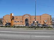
Calumet Heights is part of City of Chicago School District #299 and City Colleges of Chicago District #508. The nearest City Colleges campus was Olive–Harvey College in Pullman. A high school diploma had been earned by 88.5% of Calumet Heights residents and a bachelor's degree had been earned by 27.4% of residents.[1] The Bronzeville Children's Museum, the only children's museum in the United States focused on African-American history moved to Calumet Heights from Evergreen Park, Illinois in the early 2000s.[11]
Geography
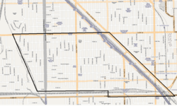
Calumet Heights is bounded by 87th Street on the north, South Chicago Avenue on the east, and railroad lines on the west and south (along 95th Street). It includes the
Politics
Calumet Heights is a stronghold for the
At the local level, Calumet Heights is located in Chicago's 7th, 8th, and 10th represented by Democrats
Notable people
- Dorothy A. Brown, Clerk of the Circuit Court of Cook County (2000–present)[17]
- Common, rapper, actor, and winner of the Academy Award for Best Original Song for Glory. He was raised in Calumet Heights.[18]
- Greg Mitchell, Alderman from Chicago's 7th ward. He is a longtime resident of Calumet Heights.[19]
References
- ^ a b c d e f g h "Community Data Snapshot - Calumet Heights" (PDF). cmap.illinois.gov. MetroPulse. Retrieved November 28, 2017.
- ^ a b c Kouri, Charles (November 22, 1991). "Upwardly mobile Calumet Heights a 'high-end' community". Chicago Tribune – via ProQuest.
- ^ Encyclopaedia Chicago: Calumet Heights
- Chicago, Illinois. Retrieved April 16, 2018 – via NewsBank.
- ISBN 0-8203-2013-7.
- ^ White, John C. (February 6, 1983). "A neighborhood success story: Community changes color, but remains stable". Chicago Tribune. p. 5 – via ProQuest.
- ^ "Economic Fact Sheet #1: Chicago and Cook County Economic Trends" (PDF). University of Illinois Chicago. July 11, 2016. Retrieved July 12, 2017.
- ^ "Commercial Avenue TIF". City of Chicago Department of Planning and Development. Retrieved January 3, 2018.
- ^ "Chicago III (2016)" (PDF). Illinois Department of Commerce and Economic Opportunity. January 23, 2018. Archived from the original (PDF) on April 17, 2018. Retrieved April 17, 2018.
- ^ "Illinois Enterprise Zone Act (20 ILCS 655/)". Illinois General Assembly. February 28, 1990. Retrieved April 16, 2018.
- ProQuest 420731623.
- DNAinfo.com. Archived from the originalon March 17, 2017. Retrieved March 16, 2017.
- DNAinfo.com. Archived from the originalon March 17, 2017. Retrieved March 16, 2017.
- ^ Connolly, Colleen (February 6, 2015). "Get to Know Your Ward: 7th Ward". Ward Room. WMAQ-TV. Retrieved December 25, 2017.
- ^ Connolly, Colleen (February 6, 2015). "Get to Know Your Ward: 8th Ward". Ward Room. WMAQ-TV. Retrieved December 27, 2017.
- ^ Connolly, Colleen (February 6, 2015). "Get to Know Your Ward: 10th Ward". Ward Room. WMAQ-TV. Retrieved December 27, 2017.
- ^ Nickeas, Peter (February 23, 2019). "Blaze strikes Clerk Dorothy Brown's home". Chicago Tribune. Retrieved February 23, 2019.
- ^ Bazer, Mark (September 17, 2014). "Common is Back in the Neighborhood". No. October 2014. Chicago magazine.
- Chicago, Illinois: Chicago Sun-Times. Retrieved December 27, 2018.
