
Cape (geography)
This article has multiple issues. Please help improve it or discuss these issues on the talk page. (Learn how and when to remove these template messages)
|
Cape Hangklip
(right) in South Africa, from space

In geography, a cape is a headland, peninsula or promontory extending into a body of water, usually a sea.[1] A cape usually represents a marked change in trend of the coastline, often making them important landmarks in sea navigation. This also makes them prone to natural forms of erosion, mainly tidal actions, resulting in a relatively short geological lifespan. Capes can be formed by glaciers, volcanoes, and changes in sea level. Erosion plays a large role in each of these methods of formation.[citation needed]
Gallery
-
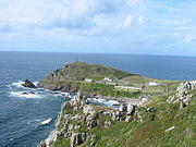 Cape Cornwall, England
 -
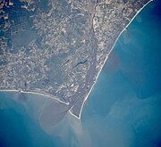 Satellite image ofCape Fear, North Carolina
 -
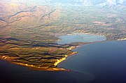
 Cape MacLear, Malawi
 -
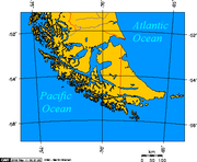 Map depicting Cape Horn at the southernmost portion of South America
 -
 Photograph of Cabo Mayor in Santander, Spain
 -
 Photograph of Cape Cambell, New Zealand, at sunrise


.jpg)


See also
- Extreme points of Africa
- Extreme points of Asia
- Extreme points of Europe
- Extreme points of North America
- Extreme points of South America
References
- ISBN 0-14-051094-X.
External links
Wikimedia Commons has media related to Capes (geography).

