
Cape Point


Cape Point (
Peaks
The peak above Cape Point is higher than that above the Cape of Good Hope. The rugged sandstone (Table Mountain sandstone) ridge that rises from Cape Point at sea level develops into two peaks. There is a major peak that dominates the skyline locally, but there is also a smaller peak about 100 m (328 ft) further south. The higher peak has the old lighthouse on the top. The Flying Dutchman Funicular runs from a car park to the north up to slightly below the level of the old lighthouse, and a short flight of steps leads to a viewing platform around the base of the lighthouse. From the end of the railway, a second path leads to a lower peak.
Lighthouse
The new lighthouse is at a lower elevation (87 meters; 285.5 feet above sea level), for two reasons: the old lighthouse, located at 34°21′12″S 18°29′25.2″E / 34.35333°S 18.490333°E (262 meters; 859.6 feet above sea level), could be seen 'too early' by ships rounding the point towards the east, causing them to approach too closely. Secondly, foggy conditions often prevail at the higher levels, making the older lighthouse invisible to shipping. On 18 April 1911, the Portuguese liner Lusitania was wrecked just south of Cape Point at 34°23′22″S 18°29′23″E / 34.38944°S 18.48972°E on Bellows Rock for precisely this reason, prompting the relocation of the lighthouse.
The new lighthouse, located at 34°21′26″S 18°29′49″E / 34.35722°S 18.49694°E, cannot be seen from the West until ships are at a safe distance to the South. The light of the new Cape Point lighthouse is the most powerful on the South African coast, with a range of 63 kilometres (39 mi; 34 nmi) and an intensity of 10
Table Mountain National Park
Cape Point is situated within the Table Mountain National Park, within a section of the park referred to as Cape of Good Hope. This section covers the whole of the southern tip of the Cape Peninsula and which takes in perhaps 20% of its total area.[3] The Cape of Good Hope section of the park is generally wild, unspoiled and undeveloped and is an important haven for seabirds. The vegetation at Cape Point consists primarily of Peninsula Sandstone Fynbos.
Ocean currents
Cape Point is often mistakenly claimed to be the place where the cold
Fishing is good along the coast but the unpredictable swells make angling from the rocks very dangerous. Over the years scores of fishermen have been swept to their deaths from the rocky platforms by freak waves.
Climate research
Cape Point is the site of one of the
Gallery
-
 The "new" lighthouse of 1919, atop Dias Point, essentially Cape Point
 -
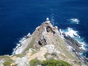
 The old lighthouse at the top of the Cape Point promontory, in use from 1860 to 1919
 -
 Cape Point and the new lighthouse as seen from the west. False Bay is beyond.
 -
 White surf breaks around Dias Rock, just offshore from the point
 -
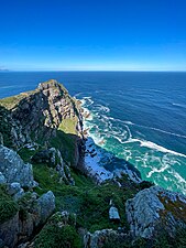 View from one of Cape Point's observation points (-34.3538, 18.4897) in Table Mountain National Park


References
- ^ Topo map of Cape Point[permanent dead link], from the South African Geographical Names System
- ^ Cape Point Attractions: Cape Point, Cape Town, South Africa, from South Africa Explored
- ^ Map of the park, showing the Cape Point section.