
Carbonate platform

A carbonate platform is a
Carbonate precipitation from seawater
What makes carbonate platform environments different from other depositional environments is that carbonate is a product of precipitation, rather than being a sediment transported from elsewhere, as for sand or gravel.[1][6] This implies for example that carbonate platforms may grow far from the coastlines of continents, as for the Pacific atolls.
The
Classification
The three types of precipitation (abiotic, biotically induced and biotically controlled) cluster into three "carbonate factories". A carbonate factory is the ensemble of the
Platforms produced by the "tropical factory"
In these carbonate factories, precipitation is biotically controlled, mostly by
Platforms produced by the "cool-water factory"
In these carbonate factories, precipitation is biotically controlled by heterotrophic organisms, sometimes in association with photo-autotrophic organisms such as red algae. The typical skeletal association includes foraminifers, red algae and molluscs. Despite being autotrophic, red algae are mostly associated to heterotrophic carbonate producers, and need less light than green algae. The range of occurrence of cool-water factories extends from the limit of the tropical factory (at about 30◦) up to polar latitudes, but they could also occur at low latitudes in the thermocline below the warm surface waters or in upwelling areas.[9] This type of factories has a low potential of carbonate production, is largely independent from sunlight availability, and can sustain a higher amount of nutrients than tropical factories. Carbonate platforms built by the "cool-water factory" show two types of geometry or depositional profile, i.e., the homoclinal ramp or the distally-steepened ramp. In both geometries there are three parts: the inner ramp above the fair weather wave base, the middle ramp, above the storm wave base, the outer ramp, below the storm wave base. In distally steepened ramps, a distal step is formed between the middle and outer ramp, by the in situ accumulation of gravel-sized carbonate grains [9]
Platforms produced by the "mud-mound factory"
These factories are characterised by abiotic precipitation and biotically induced precipitation. The typical environmental settings where "mud-mound factories" are found in the Phanerozoic are dysphotic or aphotic, nutrient-rich waters that are low in oxygen but not anoxic. These conditions often prevail in the thermocline, for example at intermediate water depths below the ocean's mixed layer.[6] The most important component of these platforms is fine-grained carbonate that precipitates in situ (automicrite) by a complex interplay of biotic and abiotic reactions with microbes and decaying organic tissue.[6] Mud-mound factories do not produce a skeletal association, but they have specific facies and microfacies, for example stromatolites, that are laminated microbialites, and thrombolites, that are microbialites characterized by clotted peloidal fabric at the microscopic scale and by dendroid fabric at the hand-sample scale. The geometry of these platforms is mound-shaped, where all the mound is productive, including the slopes.[6]
Geometry of carbonate platforms
Several factors influence the geometry of a carbonate platform, including inherited topography, synsedimentary tectonics, exposure to currents and trade winds. Two main types of carbonate platforms are distinguished on the base of their geographic setting: isolated (as Maldives atolls) or epicontinental (as the Belize reefs or the Florida Keys). However, the one most important factor influencing geometries is perhaps the type of carbonate factory. Depending on the dominant carbonate factory, we can distinguish three types of carbonate platforms: T-type carbonate platforms (produced by "tropical factories"), C-type carbonate platforms (produced by "cool-water factories"), M-type carbonate platforms ("produced by mud-mound factories"). Each of them has its own typical geometry.[6]

T-type carbonate platforms
The depositional profile of T-type carbonate platforms can be subdivided into several
The carbonate hinterland is the most landward environment, composed by weathered

The internal
The
The slope is the outer part of the platform, connecting the reef with the basin. This depositional environment acts as sink for excess carbonate sediment: most of the sediment produced in the lagoon and reef is transported by various processes and accumulates in the slope, with an inclination depending on the grain size of sediments, and that could attain the settlement angle of gravel (30-34°) at most.[8] The slope contains coarser sediments than the reef and lagoon. These rocks are generally rudstones or grainstones.
The periplatform basin is the outermost part of the t-type carbonate platform, and carbonate sedimentation is there dominated by density-cascating processes.[10]
The presence of a rim damps the action of waves in the back reef area and a lagoon may develop in which carbonate mud is often produced. When reef accretion reaches the point that the foot of the reef is below wave base, a slope develops: the sediments of the slope derive from the erosion of the margin by waves, storms and gravitational collapses. This process accumulates coral debris in clinoforms. Clinoforms are beds that have a sigmoidal or tabular shape, but are always deposited with a primary inclination.
The size of a T-type carbonate platform, from the hinterland to the foot of the slope, can be of tens of kilometers.[6]
C-type carbonate platforms
C-type carbonate platforms are characterized by the absence of early
M-type carbonate platforms
M-type carbonate platforms are characterized by an inner platform, an outer platform, an upper slope made by microbial boundstone, and a lower slope often made by breccia. The slope may be steeper than the angle of repose of gravels, with an inclination that may attain 50°.
In the M-type carbonate platforms the carbonate production mostly occurs on the upper slope and in the outer part of the inner platform.[7][11]

Carbonate platforms in the geological record
Sedimentary sequences show carbonate platforms as old as the


In the Cretaceous period there were platforms built by bivalvia (rudists).
Sequence stratigraphy of carbonate platforms
With respect to the sequence stratigraphy of siliciclastic systems, carbonate platforms present some peculiarities, which are related to the fact that carbonate sediment is precipitated directly on the platform, mostly with the intervention of living organisms, instead of being only transported and deposited.[1] Among these peculiarities, carbonate platforms may be subject to drowning, and may be the source of sediment via highstand shedding or slope shedding.[6]
Drowning
Drowning of a carbonate platform is an event where the
Several drowned carbonate platforms have been found in the geologic record. However, it has not been very clear how the drowning of carbonate platforms exactly happen. Modern carbonate platforms and reefs are estimated to grow approximately 1,000 μm/yr, possibly several times faster in the past. 1,000 μm/yr growth rate of carbonates exceeds by orders of magnitude any relative sea level rise that is caused by long-term subsidence, or changes in eustatic sea level. Based on the rates of these processes, drowning of the carbonate platforms should not be possible, which causes "the paradox of drowned carbonate platforms and reefs".[12]
Since drowning of carbonate platforms requires exceptional rise in the
One example of a drowned carbonate platform is located in
Plate movements carrying carbonate platforms to latitudes unfavourable for carbonate production are also suggested to be one of the possible reasons for drowning[further explanation needed].[12][7] For example, guyots located in the Pacific Basin between Hawaiian and Mariana Islands are believed to be transported to low southern latitudes (0-10°S) where equatorial upwelling occurred.[7] High amounts of nutrients and higher productivity caused decrease in water transparency and increase in bio-eroders populations, which reduced carbonate accumulation and eventually led to drowning[further explanation needed].[7][14]
Highstand shedding

Highstand shedding is pronounced on tropical carbonate platforms because of the combined effect of sediment production and
Slope shedding
Slope shedding is a process typical of microbial platforms, in which the carbonate production is nearly independent from sea level oscillations. The carbonate factory, composed of microbial communities precipitating microbialites, is insensitive to light and can extend from the platform break down the slope to hundreds of meters in depth. Sea level drops of any reasonable amplitude would not significantly affect the slope production areas. Microbial boundstone slope systems are remarkably different from tropical platforms in sediment productions profiles, slope readjustment processes and sediment sourcing. Their progradation is independent from platform sediment shedding and largely driven by slope shedding.[11]
Examples of margins that may be affected of slope shedding that are characterized by various contributions of microbial carbonate growth to the upper slope and margin, are:
- the Canning Basin in Australia
- the Guilin platform in the southern China
- the Permian of the US Permian Basin
- the middle Triassic carbonate platforms of the Dolomites.[11]
Gallery
-
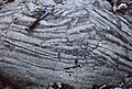
 "Shallowing upward" cycle in the Aganane Formation of the high Atlas (Morocco). Algal dolomitized laminations on top.
 -
 "Shallowing upward" cycles in the lagoonal Lias of the Musandam Peninsula. (N-Oman).
 -
 "Shallowing upward" liassic cycles arranged in decametric sequences, Musandam Peninsula, (N-Oman).
 -
 "Shallowing upward" cycle in the Middle Jurassic (Saghtan form.) of the jbel Laghdar Range (Oman).
 -
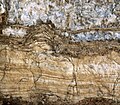
 Desiccation figures on top of a regressive sequence; Aganane Formation, High Atlas, Morocco.
 -
 Ammonites and belemnites washed over a supratidal surface (calcretes and "teepees"); Aganane Formation of the High Atlas, Morocco.
 -
 Hurricane breccia cemented (early diagenesis) at the surface of a bed, top of a regressive, metric, sequence. Aganane Formation, High Atlas.
 -
 Vadose ferrugenous pisolites (soil) and coastal (tempestite) sediment with birdseyes in an outer platform environment. Aerial diagenesis. Aganane Formation, High Atlas, Morocco.
 -
 Meniscus and point contact cement in a marine grainstone with displaced foraminifera (by tide and hurricanes) on the supratidal flat of the middle liassic platform of Morocco. Top of emersive cycle. Middle Atlas.
 -
 Reworked calcretes concretions from the supratidal environment in a marine (dolomitised) sediment displaced by hurricanes on the inner platform flat. Top of emersive sequence. Aganane Formation, High Atlas, Morocco.
 -
 Stalactitic cement in sediment from the supratidal zone, vadose environment, top of "shallowing upward" sequence. Aganane Formation, High Atlas. Thin section. L = 0.3 mm.
 -
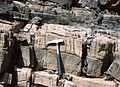
 Giant dinosaur tracks (sauropod) on top of a regressive sequence, Aganane Formation, High Atlas, Morocco.
 -
 Vadose stalactitic cement filling an horizontal cavity in a marine coastal sediment, outer platform. Birdseyes in the allodapic (tidal or tempestite) grainstone point to an aerial diagenesis. Aganane Formation, High Atlas, Morocco.
 -
 Autocyclic filling (metric to hectometric) sequences in the Middle Liassic lagoon, South (Todhra) of the Aganane Formation, High Atlas, Morocco.
 -
 "Teepee" structure, due to increasing sediment volume by dolomitisation on the inner platform supratidal flat. Top of emersive cycle. Middle Lias, Aganane Formation, High Atlas.
 -
 Quaternary to recent equivalent of a "shallowing upward sequence", cores in a Tunisian "chott", intertidal laminations in yellow.
 -
 Recent "teepee" structures in a Tunisian salt lagoon, "chott".
 -
 Recent equivalents of "shallowing upward sequences", cores in a Tunisian salt lagoon, "chott".
 -
 Top of a regressive sequence with algal laminations (yellow) and crystallised gypsum, salt lagoon "chott", Tunisia.
 -
 Eolian bioclastic (calcareous algae and porcellaneous foraminifera) sand dune on Tunisian shore.


See also
- Ocean bank (topography)
- Bahama Banks
Footnotes
- ^ OCLC 1366180.
- ISSN 0037-0738.
- ^ Geologic Map of Florida[permanent dead link]
- ^ "Bahamas Introduction". www.tamug.edu. Archived from the original on 2009-11-22. Retrieved 2006-03-09.
- ^ "ReefGIS - Location of Coral Reefs - Reef Basemap". Archived from the original on 2008-05-16. Retrieved 2007-03-12.
- ^ ISBN 978-1565761162.
- ^ S2CID 129859376.
- ^ ISSN 1365-3091.
- ^ ISSN 0012-8252.
- ISSN 0091-7613.
- ^ ISSN 0037-0738.
- ^ ISSN 0016-7606.
- ISSN 0025-3227.
- JSTOR 3514476.
- .
References
- Davaud E. & Septfontaine M. (1995): "Post-mortem onshore transportation of epiphityc foraminifera: recent example from the Tunisian coast line". Jour. Sediment. Research, 65/1A, 136–142.
- Bosellini A., 1984, "Progradation geometries of carbonate platforms: examples from the Triassic of the Dolomites, northern Italy". Sedimentology, Vol. 31, pp. 1–24
- "Bahamas Introduction" (Accessed 3/8/06)
- About.com: "Geologic Map of Florida" (Accessed 3/8/06)[permanent dead link]
- Pinet P. R., 1996, Invitation to Oceanography. St. Paul: West Publishing Company, ISBN 0-314-06339-0
- Septfontaine M. 1985, "Depositional environments and associated foraminifera (lituolids) in the middle liassic carbonate platform of Morocco." Rev. de Micropal. 28/4 265–289. See also www.palgeo.ch/publications.