
Castle Mill Stream


Castle Mill Stream is a backwater of the River Thames in the west of Oxford, England. It is 5.5 km long.[1]
Course
The stream leaves the main course of the River Thames at the south end of
Further south, the Isis Lock gives access to the Oxford Canal, and the short Sheepwash Channel leads west under the railway tracks to the main stream of the Thames.[2] The stream then flows under Hythe Bridge, on Hythe Bridge Street, and under a series of bridges: Pacey's Bridge on Park End Street, Quaking Bridge, and Swan Bridge (once known as Castle Bridge),[3] outside the original medieval city walls of Oxford, near Oxford Castle.[4] It continues under Oxpens Road and rejoins the Thames immediately upstream of the Gasworks Bridge.
History
The stream was altered greatly in
In the
Gallery
-
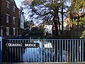 The Castle Mill Stream at Quaking Bridge.
 -
 The restored Old Malthouse on the Castle Mill Stream and Tidmarsh Lane, dating from the early 19th century.
 -
 On the left is the walkway along the Castle Mill Stream, leading fromSt Thomas' Street to Park End Street.
 -
 The Castle Mill Stream, near Oxpens Road.
 -
 Looking the mill stream towards Oxford Castle.
 -
 The Castle Mill Stream flowing under Hythe Bridge.
 -
 Isis Lock, linking the mill stream (right) and the Oxford Canal (left).
 -
 The railway bridge over the mill stream nearPort Meadow, north of Oxford railway station and just south of Walton Well Road.


See also
- Castle Mill, an Oxford University graduate housing complex
References
- ^ Oxford Area Flood Information Guidance Booklet Archived 14 December 2011 at the Wayback Machine page 37
- ^ "River Thames (Sheepwash Channel)". www.canalplan.org.uk. UK. Retrieved 15 September 2012.
- ^ Crossley, Alan; Elrington, C.R. (eds.); Chance, Eleanor; Colvin, Christina; Cooper, Janet; Day, C.J.; Hassall, T.G.; Selwyn, Nesta (1979). A History of the County of Oxford, Volume 4: Communications: Bridges. Victoria County History.
{{cite book}}:|first2=has generic name (help) - ^ Crossley, Alan; Elrington, C.R. (eds.); Chance, Eleanor; Colvin, Christina; Cooper, Janet; Day, C.J.; Hassall, T.G.; Selwyn, Nesta (1979). A History of the County of Oxford, Volume 4: City Walls, Gates, and Posterns. Victoria County History.
{{cite book}}:|first2=has generic name (help) - ^ City of Oxford, "Oxford Castle" Archived 16 January 2008 at the Wayback Machine
- ^ Crossley, Alan; Elrington, C. R. (eds.); Chance, Eleanor; Colvin, Christina; Cooper, Janet; Day, C. J.; Hassall, T. G.; Selwyn, Nesta (1979). A History of the County of Oxford, Volume 4: Communications: Rivers and River Navigation. Victoria County History.
{{cite book}}:|first2=has generic name (help)
External links
 Media related to Castle Mill Stream, Oxford at Wikimedia Commons
- Where Thames Smooth Waters Glide: Oxford Old River