Catalan Bay
| Catalan Bay | |
|---|---|
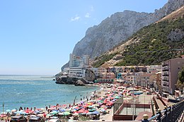
 View of Catalan Bay looking South | |
 Click on the map for a fullscreen view | |
| Location | |
| Country | Gibraltar |
| Location | Gibraltar |
| Coordinates | 36°08′20″N 5°20′29″W / 36.13875°N 5.34128°W |
| Details | |
| Owned by | Government of Gibraltar |
| Type of harbour | Natural |


Catalan Bay (
Etymology
Although the origin of Catalan Bay's name is documented, a couple of theories co-exist. Documentary evidence suggests that the bay is named after a group of around 350
The name La Caleta (meaning 'small bay or cove') considerably pre-dates that of Catalan Bay. The fishing villages of
In 1704, during the capture of Gibraltar by an Anglo-Dutch combined operation, an expedition landed there of around 350 Catalans followers of
Subsequently, the conquest, some of these Catalan soldiers settled in Gibraltar, after the departure of the majority of troops used in the conquest, and helped establish the first military checkpoint of Gibraltar. The Catalan Alfons de la Capella, lawyer of the Royal Council of Catalonia, became a judge in Gibraltar. The Catalan Josep Corrons was appointed Alcaide of the Sea (responsible for the harbour) and later was appointed Sergeant Major of Gibraltar. The Catalan Andreu Martí (one of the first to take the stronghold of the port in the conquest of the Rock) was responsible for directing the work of the prisoners after the conquest. The Catalan Jeroni Fàbregas was responsible for the distribution of ammunition.
In the 1705 siege, the Catalan soldiers fought again in defence of Gibraltar, especially in an area then called "Catalan Guard" or "Catalan Post" in Wolf's Leap (Johann Argathelu map at first third of the eighteenth century, Gabriel Bodenehr map 1720, Johann Bowles brothers map 1727, etc.).
In 1709, Catalan Josep Valls, a Gibraltar resident, collaborating with Catalan traders Salvador Feliu de la Penya, Joan Verivol, Josep Grasses, and Josep Boigues, created a commercial company called "Companyia Nova de Gibraltar" (New Company of Gibraltar), in order to replace the monopoly of Cádiz in ocean trade, that would endure until 1723.[3][4] Another theory suggests that the latter could simply be an English mispronunciation of Caleta.[1]
History
Historically, Catalan Bay had been populated by
During the nineteenth century only fishermen were permitted to live in Catalan Bay. They were required to have a fishing permit granted to them by the Governor and only a limited number of permits were issued. The families who live in the village today are mainly descendants of these Genoese fishermen,[1] and are colloquially known as caleteños.
Present
The beach at Catalan Bay, is the second biggest sandy beach in Gibraltar. It is very popular with both Gibraltarians and tourists, and can often become overcrowded during the summer months.
One of the few hazards that can call for red flags to be flown is to warn bathers of jellyfish. Occasionally jellyfish such as the Mauve Stinger can arrive in significant numbers.[5] Catalan Bay is home to the
To the north lies
See also
Further reading
- Catalan Bay - E.G. Archer, E.P. Vallejo and Tito Benady
References
- ^ a b c d [G. Hills, 1974 Rock of Contention: A History of Gibraltar- Catalan Bay]
- ^ Jose Carlos de Luna (1949), Historia de Gibraltar
- ^ G. Hills, Rock of Contention: A History of Gibraltar. (1974)
- ^ J.M. Batista i Roca, Els catalans i Gibraltar. (El Llamp Editorial)
- ^ Jellyfish Invasion Archived 2016-03-03 at the Wayback Machine, accessed 7 November 2012
- ^ The Melting Pot Archived 2007-08-15 at the Wayback Machine
External links
 Media related to Catalan Bay at Wikimedia Commons


