
Caucasus Mountains
This article needs additional citations for verification. (April 2023) |
| Caucasus Mountains | |
|---|---|
 Aerial view of the Caucasus Mountains | |
| Highest point | |
| Peak | Mount Elbrus |
| Elevation | 5,642 m (18,510 ft)[1] |
| Listing | Seven Summits |
| Coordinates | 43°21′18″N 42°26′31″E / 43.35500°N 42.44194°E |
| Dimensions | |
| Length | 1,200 km (750 mi) |
| Width | 160 km (99 mi) |
| Area | 477,165 km2 (184,234 sq mi) |
| Geography | |
 Topographic map
| |
| Countries | Russia, Georgia, Azerbaijan and Armenia |
| Continent | Eurasia |
| Range coordinates | 42°30′N 45°00′E / 42.5°N 45°E |

The Caucasus Mountains[a] is a mountain range at the intersection of Asia and Europe. Stretching between the Black Sea and the Caspian Sea, they are surrounded by the Caucasus region and are home to Mount Elbrus, the highest peak in Europe at 5,642 metres (18,510 ft) above sea level.
The Caucasus Mountains include the
Geology
Geologically, the Caucasus Mountains belong to the
The Caucasus Mountains formed largely as the result of a
The entire region is regularly subjected to strong earthquakes from this activity.[6] While the Greater Caucasus Mountains have a mainly folded sedimentary structure, the Lesser Caucasus Mountains are largely of volcanic origin.[7]
The
Notable peaks
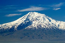
The table below lists some of the highest peaks of the Caucasus. With the exception of Shkhara, the heights are taken from Soviet 1:50,000 mapping. The list includes the ten ultras (mountains of more than 1,500 m prominence) and all mountains over 4,500 m height with 300 m prominence. Mount Ararat (5,137 m) in Turkey is just south of the Lesser Caucasus.
Some of the Highest peaks in the Caucasus Mountains Peak name Elevation
(metres)Prominence
(metres)Country Elbrus5,6424,741Russia Dykh-Tau 5,2052,002Russia Shkhara 5,193[b]1,365Georgia / Russia Koshtan-Tau 5,152822Russia Pushkin peak 5,100110Russia Janga
(Dzhangi-Tau)5,085300Georgia / Russia Mizhirgi 5,04710Russia Kazbek5,0342,353Georgia / Russia Katyn-Tau 4,979240Georgia / Russia Kukurtlu Dome 4,97818Russia Gistola 4,860320Georgia / Russia Shota Rustaveli 4,860c. 50Georgia / Russia Tetnuldi 4,858672Georgia Jimara
(Jimari)4,780840Georgia / Russia Ushba 4,7101,143Georgia Dumala-Tau 4,682332Russia Gora Uilpata 4,6491300Russia Tikhtengen 4,618768Georgia / Russia Ailama 4,5471,067Georgia / Russia Tiutiun-Tau 4,540380Russia Jailik 4,533926Russia Salinan 4,508621Russia Tebulosmta 4,4992,145Georgia / Russia Mount Bazardüzü 4,4662,454Azerbaijan / Russia Mount Shan4,4511,775Georgia / Russia Tepli 4,4311,144Russia Diklo 4,285843Georgia / Russia Mount Shahdagh 4,2431,102Azerbaijan Gora Addala
Shukgelmezr4,1521,792Russia Gora Dyultydag4,1271,834Russia Aragats4,0902,143Armenia Deavgay 4,0161,251Russia
Climate

The climate of the Caucasus varies both vertically (according to elevation) and horizontally (by latitude and location). Temperature generally decreases as elevation rises. Average annual temperature in
Precipitation increases from east to west in most areas. Elevation plays an important role in the Caucasus and mountains generally receive higher amounts of precipitation than low-lying areas. The north-eastern regions (
The Caucasus Mountains are known for the high amount of snowfall, although many regions which are not located along the windward slopes do not receive nearly as much snow. This is especially true for the Lesser Caucasus Mountains which are somewhat isolated from the moist influences coming in from the
Snow cover in several regions (Svaneti and northern Abkhazia) may reach 5 metres (16 ft). The Mt. Achishkho region, which is the snowiest place in the Caucasus, often records snow depths of 7 m (23 ft).
Landscape

The Caucasus Mountains have a varied landscape which changes according to elevation and distance from large bodies of water. The region contains
The northern slopes of the Greater Caucasus Mountains are covered by
The northern and western slopes of the Lesser Caucasus Mountains are characterized both by
History
Crossing the Caucasus Mountain range was an important section of the northern arm of the
Image gallery
-
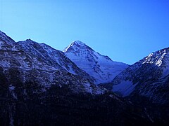
 Mount Elbrus viewed from the south in Kabardino-Balkaria
 -
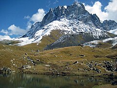
 Komito Mountain in Chechnya
 -

-
-
-

-
-
-
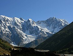
 Asbestnaya Mount and Acheshbok Mount, Russia
 -
 Bolshoy Tkhach Park, Russia


.jpg)


.jpg)


See also
Notes
- ^ Native names:
- pronounced [kʼafkʼasioni]
- Armenian: Կովկասյան լեռներ, Kovkasyan leṙner
- pronounced [kɔvkɑsjɑn lɛrˈnɛɾ]
- Azerbaijani: Qafqaz dağları, pronounced [qɑfqɑz dɑʁlɑrɯ]
- Russian: Кавка́зские го́ры, tr. Kavkázskiye góry, IPA: [kɐfˈkasːkʲɪje ˈɡorɨ]
- Turkish: Kafkas Dağları, Turkish pronunciation: [kafkas daːɫaɾɯ]
- Persian: كوه هاى قفقاز
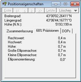
- ^ The elevation and coordinates given here are taken from a DGPS survey by Peter Schoen and Boris Avdeev, in association with "GeoAT".. It was carried out in July 2010 and "made available". November 2010. in November 2010.
Elbrus. The true [maximum] elevation is on higher ground, still further east along the Shkhara ridge.
References
- ^ "Topographic map of Mount Elbrus". opentopomap.org. Retrieved 2023-04-14.
- ISBN 978-90-481-2641-5.
- ISSN 1674-9871.
- ^ OCLC 671359683, retrieved 2021-01-09
- ^ Adamia, Shota; Zakariadze, Guram; Chkhotua, Tamar; Sadradze, Nino; Tsereteli, Nino; Chabukiani, Aleksandre; Gventsadze, Aleksandre (January 2011). "Geology of the Caucasus: A Review" (PDF). Turkish J. Earth Sci. 20: 489–544.
- .
- .
- ^ "Mt. Elbrus". NASA Earth Observatory. NASA. 7 July 2003. Archived from the original on 15 December 2018. Retrieved 16 February 2015.
- ^ Durn, Sarah (2023-03-02). "The Stark Beauty of Tushetian Shepherds' Journey Across Georgia's Caucasus Mountains". Atlas Obscura. Retrieved 2023-03-08.
- Parts of this article are from the NASA Earth Observatory: "Mt. Elbrus". Earth Observatory (image & text). newsroom / new images. NASA. 12 September 2000. Archived from the original on 2005-10-28.
Further reading
- Kropotkin, Peter Alexeivitch; Bealby, John Thomas (1911). . Encyclopædia Britannica. Vol. 5 (11th ed.). pp. 550–555.
- Cornell, Svante E. (1 December 2000). Small Nations and Great Powers: A study of ethnopolitical conflict in the Caucasus (1st ed.). Routledge. ISBN 978-070071162-8.
Sets out a synthesis of the Caucasian conflicts and a conclusion on the place of the Caucasus in world affairs.
External links
- "Caucasus Mountains". NASA Earth Observatory. 7 November 2001.
- "Highest Peaks of the Caucasus from peakbagger.com". Peakbagger.com.
- "List of the most prominent mountains in the Caucasus". Peaklist.org.
- "What to see in Caucasus Mountains" (tourism promotion / commercial). Archived from the original on 2020-10-24. Retrieved 2021-09-20.
| International | |
|---|---|
| National | |
| Geographic | |