
Cauterets
Cauterets | |
|---|---|
 The town hall of Cauterets | |
.svg) Coat of arms | |
Location of Cauterets  | |
 Cauterets  Cauterets | |
| Coordinates: 42°53′N 0°07′W / 42.89°N 0.11°W | |
| Country | France |
| Region | Occitania |
| Department | Hautes-Pyrénées |
| Arrondissement | Argelès-Gazost |
| Canton | La Vallée des Gaves |
| Intercommunality | Pyrénées Vallées des Gaves |
| Government | |
| • Mayor (2020–2026) | Jean-Pierre Florence[1] |
| Area 1 | 156.84 km2 (60.56 sq mi) |
| Population (2021)[2] | 866 |
| • Density | 5.5/km2 (14/sq mi) |
| Time zone | UTC+01:00 (CET) |
| • Summer (DST) | UTC+02:00 (CEST) |
| INSEE/Postal code | 65138 /65110 |
| Elevation | 503–3,300 m (1,650–10,827 ft) (avg. 1,000 m or 3,300 ft) |
| 1 French Land Register data, which excludes lakes, ponds, glaciers > 1 km2 (0.386 sq mi or 247 acres) and river estuaries. | |
Cauterets (French pronunciation: [kotʁɛ]; in Occitan Cautarés, in Catalan Cautarés, in Aragonese Cautarès) is a spa town, a ski resort and a commune in the Hautes-Pyrénées department and the region of Occitanie in south-western France.
Toponymy
Historical names:[3]
- Caldarez, (c. 1060, Cartulary of Saint-Savin; 1077–1078, ibid.; c. 1094, ibid.)
- Vallem Caldarensem, Latin (1083–1094, ibid.; 1317, Meillon, Cartulary of Saint-Savin)
- In valle Caldarea, Latin (1094–1118, ibid.)
- de Cautereis, Latin (1168, Papal bull of Alexander III)
- Cautares, (1285, Bigorre Clock)
- De Cauteresio, Latin (1342, Pouillé of Tarbes).
- De Cautaresio, Latin (1379, Tarbes proxy)
- Cauteres, (1429, Bigorre censier).
- Cauterez, (1614, Guillaume Mauran)
- Cauterés, (1790, Department 1)
- Cauterez, (1790, Department 2)
The final -t is an error, as it was never used before the 19th century.
Occitan name: Cautarés.
Geography
Cauterets is located 32 km (20 mi) southwest of

The village gives access to many hiking trails serving natural sights, such as the
The minimum altitude, 503 metres (1,650 ft), is located in the north, where the Gave de Cauterets leaves the communal area and enters that of Soulom. The maximum elevation of 3,298 metres (10,820 ft) corresponds to the highest point of the French Pyrénées, Vignemale, marking the border with Spain. Other summits in the neighbourhood include the Monné at 2,723 metres (8,934 ft), the Cabaliros at 2,333 metres (7,654 ft) and the Pic de Chabarrou at 2,910 metres (9,550 ft).
Neighbouring communes
The extensive commune of Cauterets is bordered by Spain to southwest and fourteen communes in France.
Places adjacent to Cauterets | |
|---|---|
Springs

Cauterets is well known for its copious
Climate
Cauterets has an oceanic climate (Köppen climate classification Cfb). Based on data collected between 1981 and 2010: The mean daily temperature in Cauterets was 9.9 °C (49.8 °F) and average annual rainfall was 1,238.2 mm (48.75 in), with November as the wettest month. July and August were the warmest months, with a mean high of 21.9 °C (71.4 °F), and January and February were the coldest, with a mean low of −0.3 °C (31.5 °F). Through 2015 the highest temperature recorded in Cauterets was 36.3 °C (97.3 °F) on 18 August 2012, and the lowest recorded was −18.0 °C (−0.4 °F) on 11 February 1956.
| Climate data for Cauterets (1981−2010 normals, extremes 1954−2015) | |||||||||||||
|---|---|---|---|---|---|---|---|---|---|---|---|---|---|
| Month | Jan | Feb | Mar | Apr | May | Jun | Jul | Aug | Sep | Oct | Nov | Dec | Year |
| Record high °C (°F) | 21.5 (70.7) |
24.0 (75.2) |
26.0 (78.8) |
27.0 (80.6) |
30.5 (86.9) |
35.0 (95.0) |
36.0 (96.8) |
36.3 (97.3) |
32.0 (89.6) |
29.5 (85.1) |
23.0 (73.4) |
21.0 (69.8) |
36.3 (97.3) |
| Mean daily maximum °C (°F) | 7.6 (45.7) |
8.4 (47.1) |
11.1 (52.0) |
12.6 (54.7) |
16.3 (61.3) |
19.6 (67.3) |
21.9 (71.4) |
21.9 (71.4) |
19.1 (66.4) |
15.6 (60.1) |
10.7 (51.3) |
8.0 (46.4) |
14.4 (57.9) |
| Daily mean °C (°F) | 3.6 (38.5) |
4.1 (39.4) |
6.5 (43.7) |
8.2 (46.8) |
11.5 (52.7) |
14.7 (58.5) |
17.0 (62.6) |
17.0 (62.6) |
14.3 (57.7) |
11.1 (52.0) |
6.6 (43.9) |
4.2 (39.6) |
9.9 (49.8) |
| Mean daily minimum °C (°F) | −0.3 (31.5) |
−0.3 (31.5) |
1.9 (35.4) |
3.7 (38.7) |
6.8 (44.2) |
9.8 (49.6) |
12.0 (53.6) |
12.1 (53.8) |
9.5 (49.1) |
6.6 (43.9) |
2.5 (36.5) |
0.4 (32.7) |
5.4 (41.7) |
| Record low °C (°F) | −13.5 (7.7) |
−18.0 (−0.4) |
−14.0 (6.8) |
−7.0 (19.4) |
−3.5 (25.7) |
−1.0 (30.2) |
3.0 (37.4) |
3.0 (37.4) |
−1.0 (30.2) |
−4.0 (24.8) |
−9.5 (14.9) |
−15.0 (5.0) |
−18.0 (−0.4) |
| Average precipitation mm (inches) | 128.0 (5.04) |
91.5 (3.60) |
99.7 (3.93) |
122.2 (4.81) |
108.1 (4.26) |
79.6 (3.13) |
72.1 (2.84) |
72.5 (2.85) |
86.3 (3.40) |
111.7 (4.40) |
135.4 (5.33) |
131.1 (5.16) |
1,238.2 (48.75) |
| Average precipitation days (≥ 1.0 mm) | 10.9 | 10.0 | 10.5 | 13.1 | 14.5 | 10.9 | 8.5 | 9.5 | 9.5 | 11.7 | 11.2 | 11.6 | 131.7 |
| Source: Météo-France[5] | |||||||||||||
History
Prehistory and antiquity
Prehistoric and Protohistoric remnants have been found, many in the valleys above Cauterets: Eleven stone circles, four cromlech tumuli, six individual tumuli and five dolmens. The stone circles are particularly located in the Marcadau Valley and some plains and pastures.[6]
There are few traces of the period preceding the Roman conquest. Of the Gallo-Roman period, remains were found which used Cauterets thermal waters, such as a swimming pool. On the balcony of Saint-Savin, a castrum was built as well as the Palatium Aemilianum villa. The Villa Bencer was located on the present site of the village of Cauterets.
Middle Ages
In the 8th or 9th century, a monk by the name of Sabinus came to live as a hermit in the valley. The future
Between 1059 and 1078, Bernard III, Abbot of Saint-Savin, had installed a pool called "bain d'en-haut" [bath from above]. Cabin houses were grouped around this pool. This was the beginning of the village of Cauterets (Caouteres).
In the 12th century, a conflict arose between the inhabitants of Lavedan and those of the Aspe Valley for a theft of livestock; the result was the death of several Aspe people. The Bishop of Comminges, Bertrand excommunicated the Bigorre people who were repentant. They were sentenced to life imprisonment and to pay a yearly fine on the day of Saint Michel in the Church of Saint-Savin. It was regularly paid until 1789, and it was known as the tribut des Médailles [tribute of the medals].
Three baths existed around the different hot springs and there were twenty feus in the village. Gaston Phébus came to Cauterets to treat his deafness in 1380.
Early modern period
Return to "antique" values during the Renaissance of the 16th century favoured the return to the baths and the thermal waters. Multiple visits by Marguerite de Navarre in this century gave real fame to Cauterets.
In the 16th century, the Abbey of Saint-Savin lost its prestige and decayed due to lack of maintenance. During the French Wars of Religion, hydrotherapy stopped due to the destruction and wars against Spain.
The construction of passable roads in the 18th century to La Raillère helped the development of the valley. La Raillère became a water source of fashion thanks to editions of books on the water sources of Cauterets. At the end of the 18th century, the Bruzaud Spa was built.
Contemporary period
The 19th century and the golden age of spas


The thermal baths of César, the Grand Hôtel d'Angleterre and the Grand Hotel Continental were all created along with monumental facades. All are witnesses of a 19th-century golden age of
The vogue of hydrotherapy in the 19th century brought many personalities including members of the Bonaparte family. Hortense de Beauharnais, Queen of Holland, daughter of Empress Joséphine and wife of Louis Bonaparte, King of Holland stayed in Cauterets from 18 June to 10 August 1807. On 25 July 1807, the Queen accompanied by guides Clement, Lacrampe and Martin, made the Cauterets-Gavarnie crossing by the Hourquette d'Ossoue.[7] In 1822, Vincent Chausenque, made the first ascent of the peak that now bears his name at 3,205 metres (10,515 ft) above sea level. Count Henry Russell and other famous mountaineers came to realise numerous ascents from the valley. On 8 September 1859, Napoleon III and Empress Eugenie visited Cauterets.
La Raillère was built in stone from 1818 to 1828.
Transport infrastructure developed strongly, including the line of railway between Lourdes and Pierrefitte which opened in 1871, then the Pierrefitte-Cauterets electric line in 1899, and the Cauterets-La Raillère tramway was put into service on 2 August 1897.
The 20th century: Towards a society of leisure
At the beginning of the 20th century, Louis Falisse was one of the pioneers of skiing in the Pyrenees. With Henri Sallenave and Louis Robach, he made the first ascents of the Vignemale and the Aneto on ski. They gave tribute to the Pic Falisse at 2,765 metres (9,072 ft), close to the Grande Fache. The Cauterets ski club was founded in 1907. In 1910, the France Skiing Championship was organised at Eaux-Bonnes and Cauterets. In 1918, one of the first guardians of the Walloon refuge was Pantet; Pic R.-Pantet at 2,867 metres (9,406 ft) bears his name.
In 1937, the idea of a cable car to develop the skiing was launched but postponed due to World War II.
In the 1950s, during the construction of numerous hydroelectric dams, Cauterets refused the introduction of several selected at the Pont d'Espagne.[8]
On 18 June 2013, a catastrophic flood destroyed several buildings of the village. The RD920 departmental road, the access road to Cauterets from Pierrefitte-Nestalas, was swept away by the Gave de Cauterets. The services of the General Council of the Hautes-Pyrénées commissioned a new section of road, in record time, of several hundred metres drawn on a mountainside, with a succession of spectacular laces that bypass the collapsed area.
Heraldry
|
The arms of Cauterets are blazoned : Azure to a mountain of argent, on a plain of vert, ensigned by a jackdaw sable taking off between two pots of gules.[9] Comments: The mountain recalls the geographic location of the legendary Lavedan jackdaws. The pots are filled with cold water (ice torrent) and hot water (sulphurous at 55°C) and recall the origin of the name of the city; Cauterets = hot and cold.
|
Demography
In 2017, the commune had 908 inhabitants.
|
|
| |||||||||||||||||||||||||||||||||||||||||||||||||||||||||||||||||||||||||||||||||||||||||||||||||||||||||||||||||||||
| From 1962 to 1999: Population without double counting; for the years following: municipal population. Source: Ldh/EHESS/Cassini until 1999[10] then INSEE from 2007[11] | |||||||||||||||||||||||||||||||||||||||||||||||||||||||||||||||||||||||||||||||||||||||||||||||||||||||||||||||||||||||
Politics and administration
Intercommunality
Cauterets is part of the Communauté de communes Pyrénées Vallées des Gaves, created in January 2017, which has brought together 46 communes.
List of mayors
| Start | End | Name | Party | Other details |
|---|---|---|---|---|
| March 2006 (re-elected in March 2014) | 2020 | Michel Aubry[note 1] | ||
| 2020 | 2026 | Jean Pierre Florence[1] |
Tourism
Hydrotherapy

Cauterets is a spa town with instructions in ENT and Rheumatology. The waters of its eleven sources are exploited in two institutions that receive spa guests: The Baths of César in the village of Cauterets, and the Baths of the Gryphons in the hamlet of La Raillère. Sources still remain the property of a syndicate of the neighbouring communes.
Specialties
Confectionery arrived in the 16th century in Europe, the berlingot came to the thermal water communes of the Pyrenees in the 19th century, including Cauterets, according to the recommendations of some medical practitioners, to reduce the sulphur water taste.[12] Ten berlingot manufacturers existed in Cauterets at the beginning of the 20th century. There were four shops in 2014, three of which specialised in this product.[12]
Winter sports resort

Cauterets is a winter sports resort where one can enjoy
In February 2013, Cauterets experienced a record snowfall,[13] making it the snowiest resort in the world ahead of Mammoth Mountain[14] with 5.5 metres (18 ft) at the ski resort.
Sports
The
Cycling
Vuelta a España
- 2003, stage 7, Huesca – Cauterets: Michael Rasmussen
Tour de France
- 1953, stage 10, Pau – Cauterets (2C): Jesús Loroño[15]
- 1989, stage 9, Pau – Cauterets-Cambasque (1C): Miguel Induráin[16]
- 1995, stage 15, Saint-Girons – Cauterets-Cambasque (1C): Richard Virenque[17]
- 2015, stage 11, Pau – Cauterets (2C): Rafał Majka
Places and monuments
Architectural heritage
- The Church of Our Lady, inaugurated in 1886, was erected at the site of the former demolished church in 1884.Way of the Cross", 1st Prize of World Sacred Paintings in 1996, which stands today in the church.
- Inaugurated in 1901, the old railway station of Cauterets was included in the title of historic monuments in 1981 for its façades and roofs.[19] This is an original building somewhat akin to mountain chalets, while others can see it as being in the Wild West style. The Pierrefitte-Cauterets tramway line was abandoned in 1949, it has been transformed into a greenway of 30 kilometres (19 mi). The station itself is now the place for shows and other events, only buses approach it now. Indeed, it is still a bus station.
- The old station of the aerial tramway was built by the teams of Gustave Eiffel.
- The thermal baths of César, renovated in 1999, were built in 1844.
- The entirety of Rue Richelieu, followed by Rue de la Raillère, presents itself as the historic axis of the village. Located on the right bank of the Gave de Cauterets, hotels and emblematic residences of Cauterets are found here.
- Chalet Galitzine, dating from 1840.
- Boulevard Latapie-Flurin has several notable buildings from the end of the 19th century, the Hotel d'Angleterre [England Hotel], the Continental Hotel and Casino Club.[20] The Continental Hotel, became the Continental Residence building and the Casino Club, which became the Residence du Lys, offer ornate facades of many sculptures. The Continental Residence building has been registered as a historical monument since 1984, for its main façade.[21]
- Architectural heritage
-
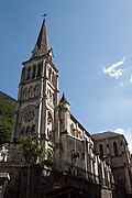 The church of Notre-Dame
 -
 The former railway station, now a bus station
 -
 Gateway to the Continental Residence building.
 -
 One of the statues of the Residence of Lys building.
 -
![The old Hotel d'Angleterre [England Hotel] and café](//upload.wikimedia.org/wikipedia/commons/thumb/6/68/Cauterets_65_R%C3%A9sidence_d%27Angleterre%26caf%C3%A9_2014.jpg/270px-Cauterets_65_R%C3%A9sidence_d%27Angleterre%26caf%C3%A9_2014.jpg) The old Hotel d'Angleterre [England Hotel] and café
The old Hotel d'Angleterre [England Hotel] and café


![The old Hotel d'Angleterre [England Hotel] and café](/File:Cauterets_65_R%C3%A9sidence_d%27Angleterre%26caf%C3%A9_2014.jpg)
Natural heritage
An extensive Pyrenean commune, Cauterets offers many natural sites in connection with the Pyrénées National Park, such as the Pont d'Espagne, Gaube Lake and the cascades which adorn the Gave de Jéret and the Gave de Lutour.
From the village of Cauterets, the Lys gondola lift and Grand Barbat chairlift provide access to the Cirque du Lys.
- Waters around Cauterets
-
 The Pont d'Espagne waterfall
 -
![The Pont d'Espagne [Bridge of Spain]](//upload.wikimedia.org/wikipedia/commons/thumb/9/98/Cauterets_pont_d%27Espagne_%281%29.JPG/135px-Cauterets_pont_d%27Espagne_%281%29.JPG) The Pont d'Espagne [Bridge of Spain]
The Pont d'Espagne [Bridge of Spain] -
![The Lac de Gaube [Gaube Lake]](//upload.wikimedia.org/wikipedia/commons/thumb/c/c3/Cauterets_lac_Gaube.JPG/240px-Cauterets_lac_Gaube.JPG) The Lac de Gaube [Gaube Lake]
The Lac de Gaube [Gaube Lake] -
 The Lutour waterfall
 -
 The Cerisey waterfall
.JPG)
![The Pont d'Espagne [Bridge of Spain]](/File:Cauterets_pont_d%27Espagne_(1).JPG)
![The Lac de Gaube [Gaube Lake]](/File:Cauterets_lac_Gaube.JPG)
.JPG)
.JPG)
Notable people
- Victor Hugo wrote a poem about Cauterets included in the third book Les Luttes et les Rêves [The struggles and dreams] of Les Contemplations: L’enfant voyant l'aïeule... [The child saw the grandmother...] (25 August 1843).
- Giuseppe Verdi and Giuseppina Strepponi stayed in Cauterets during the summer of 1866, where the maestro pursued the composition of Don Carlos and tried to heal his chronic sore throat.[22]
- Louis Varney (1844–1908), composer of operettas died here.
- Ralph Soupault (1904–1962), cartoonist in the collaborationist journal Je suis partout died in Cauterets on 12 August 1962.
- Sim (1926–2009), his real name Simon Jacques Eugène Berryer, was an actor, comedian and writer, born in Cauterets.
- On 17 November 2008, the military leader of ETA, Miguel Garikoitz Aspiazu Rubina, alias "Txeroki" [Cherokee], was arrested in Cauterets, bringing a severe blow to the Basque separatist organisation.
- have also stayed there.
Cauterets in literature
- Cauterets provides the framework of the Heptaméron, an unfinished collection of short stories written by Marguerite de Navarre. Flood waters involuntarily retained ten ladies and gentlemen at Cauterets, who were having spa treatment. They decide to entertain by telling a story each day.
Bibliography
- Flurin, René (1999). Histoire de Cauterets, des origines à nos jours [History of Cauterets, from its origins to the present day] (in French). Créer.
- Flurin, René (2010). Cauterets thermal au fil de l'histoire [Thermal Cauterets throughout history] (in French). Monhélios.
Notes
- municipal council.
References
- ^ a b "Répertoire national des élus: les maires". data.gouv.fr, Plateforme ouverte des données publiques françaises (in French). 2 December 2020.
- ^ "Populations légales 2021". The National Institute of Statistics and Economic Studies. 28 December 2023.
- ^ Grosclaude, Michel; Le Nail, Jean-François (2000). Dictionnaire toponymique des communes des Hautes-Pyrénées. Conseil général des Hautes-Pyrénées. intégrant les travaux de Jacques Boisgontier.
- ^ One or more of the preceding sentences incorporates text from a publication now in the public domain: Chisholm, Hugh, ed. (1911). "Cauterets". Encyclopædia Britannica. Vol. 5 (11th ed.). Cambridge University Press. p. 559.
- ^ "Fiche Climatologique Statistiques 1991-2020 et records" (PDF) (in French). Météo-France. Retrieved 11 September 2022.
- ISBN 978-2848190730.
- ^ "Cauterets" [Cauterets] (in French). Retrieved 17 April 2015.
- ^ "Cauterets-Pont d'Espagne, grand site de Midi-Pyrénées" [Cauterets-Pont d'Espagne, great site of the Midi-Pyrénées] (in French). Archived from the original on 21 May 2014. Retrieved 17 April 2015.
- ^ "65 138 – CAUTERETS (Hautes Pyrénées)" [65 138 – CAUTERETS (Hautes Pyrénées)] (in French). Retrieved 17 April 2015.
- ^ Des villages de Cassini aux communes d'aujourd'hui: Commune data sheet Cauterets, EHESS (in French).
- ^ Population en historique depuis 1968, INSEE
- ^ Sud Oueston 8 November 2014, p. 34-35.
- ^ "VIDEO. Cauterets, ce village où il est tombé 7 mètres de neige en 3 semaines" [VIDEO . Cauterets, the village where seven meters of snow fell in 3 weeks] (in French). Archived from the original on 22 February 2015. Retrieved 16 April 2015.
- ^ "Météo : record du monde d'enneigement à Cauterets !" [Weather: Snow world record in Cauterets!] (in French). Retrieved 16 April 2015.
- ^ "L'historique du Tour 1953". Archived from the original on 14 July 2014. Retrieved 16 April 2015.
- ^ "L'historique du Tour 1989". Archived from the original on 14 July 2014. Retrieved 16 April 2015.
- ^ "L'historique du Tour 1995". Archived from the original on 3 March 2016. Retrieved 16 April 2015.
- ^ Sur place, panneau d'information Place Pierre Jarré – Le Turoun, vu le 22 mai 2012.
- ^ Base Mérimée: PA00095365, Ministère français de la Culture. (in French)
- ^ Au nord du boulevard, panneau d'information Boulevard Latapie-Flurin, vu le 22 mai 2012.
- ^ Base Mérimée: PA00095367, Ministère français de la Culture. (in French)
- ^ Mary Jane Phillips-Matz, Giuseppe Verdi, Fayard, 1996, p. 606
External links
- Tourism office website (in French)
- Pyrenees travel guide
- French Tourist office website
- Cauterets town hall (in French)
- The thermes de Cauterets (in French)
- French ski school of Cauterets (in French)
- Cauterets on the National Geography Institute website (in French)
| International | |
|---|---|
| National | |
| Geographic | |