
Victorian Downtown Los Angeles
_to_Third_Street_(l).jpg)
The late-
At the time (1880–1900s), the area was referred to as the business center, business section or business district. By 1910, it was referred to as the "North End" of the business district which by then had expanded south to what is today called the Historic Core, along Broadway, Spring and Main roughly from 3rd to 9th streets.[3]
Location

By the mid-1890s, First and Spring was the center of the business district, and the Bradbury Building, opened in 1893 at Third and Broadway and still standing today,[4] By 1910, the area north of Fourth Street was considered the "North End" of the business district and there were already concerns about its deterioration, as the center of commerce moved to what is now known as the Historic Core, from Third to Ninth streets.[5]
Map
The map shows the street grid in 1910, and shows in blue three important road alignment changes that came in the 1920s–1950s:
- Spring Street realignment north of First Street to run parallel to Main Street
- Temple Street extension eastward from Main Street
- Creation of the US-101 Freeway and its service roads, called Arcadia and Aliso streets, but not exactly in the positions of the old Arcadia and Aliso streets
Overview of the area
Buildings
Broadway
-
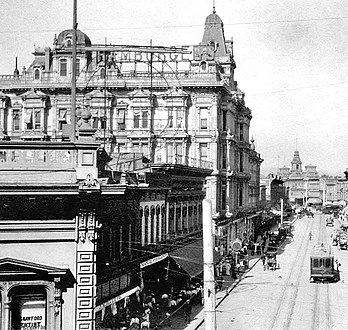
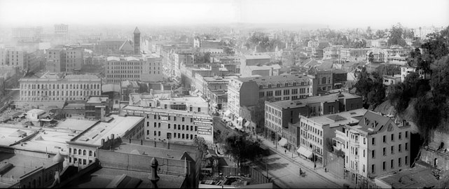 1905 view south on Broadway from north of Temple Street. The Times Mirror printing house in foreground, marked 110 N. Broadway, now site of the Hall of Justice. Towers of the 1888 City Hall on the 200 block of S. Broadway in the distance. Fort Moore Hill, now leveled, at right.
 -
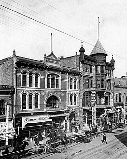
 c.1893–1900, looking east along Third St. from Olive St. on Bunker Hill. 3 buildings stand out from left to right: the 1888 City Hall (Broadway between 2nd/3rd), theStimson Block (3rd & Spring), and the Bradbury Building(3rd & Broadway)
.jpg)
.jpg)
Temple and Broadway
Northwest corner of Temple and Broadway
-
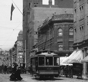
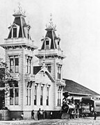
 TheTemple Street Cable Railwaycar, 1890

- The three-story brick
Southeast corner of Temple and Broadway (Pound Cake Hill, west side of New High St.)
-
 Los Angeles High School
on Pound Cake Hill, 1870s -
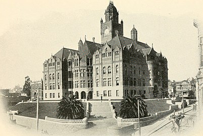 "Red Stone" Courthouse and Post Office (1891-1936)
 -
 Hall of Records, adjacent to Courthouse on the south (1911–1973)

_(14783523833).jpg)

This location was at the time known as Pound Cake Hill. The buildings located here faced New High Street to their east and Broadway to their west. They were as follows:[11]
- Fort Moore Hill, immediately north of where Broadway today crosses the Hollywood Freeway. The Pound Cake Hill school was demolished and replaced by:
- First, the Red Stone Courthouse (or "Red Sandstone Courthouse"), which took over the function of courthouse from the Clocktower Courthouse (also called the Temple Courthouse). It was damaged beyond repair by Long Beach earthquake of 1933 and was torn down in 1936.
- The Los Angeles County Hall of Records was built next to (south of) the Red Sandstone Courthouse in 1911, After the 1971 San Fernando earthquake, it was determined to be unsafe and it was demolished in 1973. A new Hall of Records was built and opened in 1962, one block west on the south side of Temple between Broadway and Hill.
Currently on the site are:
- Clara Shortridge Foltz Criminal Justice Center (Los Angeles County Grand Jury)
- A portion of Grand Park, which stretches mid-block between Temple and First, from City Hall at Spring Street, to the Music Center at Grand Avenue.
Realignment of Spring Street (1925)
The Poundcake Hill buildings originally backed up to Broadway to their west, and faced New High Street to their east. New High Street (see Sanborn map above) was a north-south street that ran parallel to Broadway, and to Spring Street to its east. As part of the construction of City Hall in the early 1920s, New High Street was removed south of Temple, and Spring Street was realigned more towards a north-south orientation, parallel with Broadway, instead of running more northeasterly and meeting Main Street at Temple Street. As a result the Poundcake Hill buildings faced the newly aligned Spring Street until they were demolished.
Southwest corner of Temple and Broadway
- The second location of the Los Angeles County Hall of Records, opened 1962.
Adjacent to the south, mid-block, is a portion of Grand Park.
First and Broadway
-
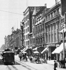
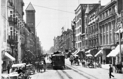 Looking south along Broadway from First Street, 1904-5. At right, from left to right: C.H. Frost Building (#145), 141-3, the turreted Roanoke Bldg (#137-9), Newell & Gammon Bldg. (#131-5), Mason Opera House (#125-9)At left Chamber of Commerce (#128), 1888 City Hall (#228-238).

Northeast corner of First and Broadway
-
 1886 Los Angeles Times Building
,_photo_about_1887.jpg)
- Los Angeles Times building, now part of Times Mirror Square, occupying the entire block between Broadway, Spring, First and Second streets.[12]
Northwest corner of First and Broadway
- Site of the Tajo Building (1896–mid-20th c.).[13] Now the location of the Los Angeles County Law Library.[4]
Southeast corner of First and Broadway and east side of 100 block
-
 1973 Pereira Addition building, Times Mirror Square
 -
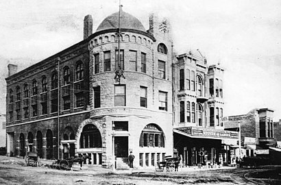
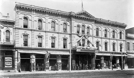
 1900s view of Chamber of Commerce, 128 S. Broadway
 -
 Postcard c.1910 of Chamber of Commerce, 128 S. Broadway


- Site of the Culver Block retail and office building.[14] Now the site of the Times Mirror Square 1973 Pereira Addition, so called because it was designed by William Pereira.
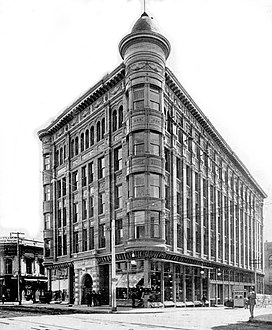
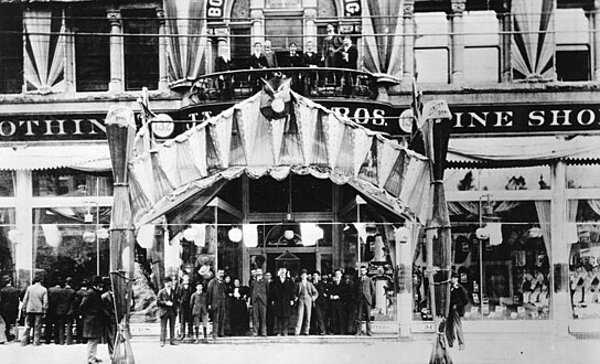
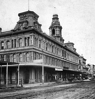
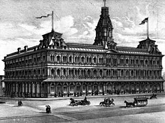
- South of the Culver Block was the Los Angeles Chamber of Commerce building, 128–130 S. Broadway, opened February 12, 1904,[15] a landmark at the time featured on postcards and in books. 6 stories, 4 floors. Ground floor offices included those of the Los Angeles Herald and Consolidated Bank.[16]
Southwest corner of First and Broadway
-
 Mason Opera House or Mason Theatre
 -
 C.H. Frost Building at 145 S. Broadway, c.1904-5. To its right, the turreted Roanoke Bldg. (#137-9), Newell & Gammon Bldg. (#131-5), and the Mason Opera House (#125-9).


The southwest corner, during Victorian times the site of unremarkable retail and office buildings, was from 1958 the location of the State Office Building, (1958-60, architect Anson C. Boyd, razed 2006). It was named the
Just south of the southwest corner was the Mason Theatre, 127 S. Broadway. Opened in 1903 as the Mason Opera House, 1,600 seats.
145 S. Broadway,
Second and Broadway
-
 Broadway looking south from 2nd St., 1895-1905. The 1888 City Hall is visible on the left (east) side.
 -
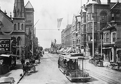 Another view of Broadway looking south from 2nd St. showing a cable car, c.1893-1895
.jpg)

Northeast corner of Second and Broadway
-
 The 2nd & Broadway Hellman Building in 1918

One of several “Hellman Buildings” across Downtown L.A. — not to be confused with the still-existing Hellman Building at Fourth and Spring — was located here (#138) from 1897 to 1959.[22] The site is now a parking structure, part of the Times Mirror Square complex.
Southwest corner of Second and Broadway and the west side of the 200 block
-
 West side of Broadway from #229 (at left) to #207 (at right, SW corner of 2nd St.) sometime after 1894. From left to right: Bicknell Block with the Los Angeles Furniture Co.; Potomac Block with Ville de Paris and City of London stores, the YMCA building with its turret and two gables, and the American National Bank building.
 -
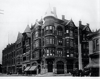 American National Bank (later California Bank) Building (1878-1911), southwest corner, 1890. To the viewer's left (south) are the turret and two gables of the YMCA Building (1889), then the Potomac Block (1890).
 -
 Merchants Trust Company Building in 1910
 -
 Potomac Block c.1890-1895.
 -
 The Ville de Paris department store, 1901
 -
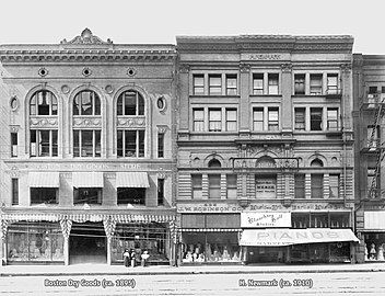 Boston Dry Goods and Harris Newmark buildings, 1899


.jpg)


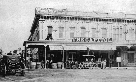
The west side of the 200 block of South Broadway had a key place in the retail history of Los Angeles from the 1893 through 1917, as it was home to several prominent early department stores such as the Ville de Paris, Coulter's department store from 1905–1917, and J. W. Robinson's "Boston Dry Goods" store from 1895–1915. All three stores would move to Seventh Street when it became the upscale shopping street between 1915 and 1917.
- On the southwest corner of 2nd and Broadway was Judge O'Melveny's house, built in 1870. This was replaced by the American National Bank (later California Bank) Building, which one turn was replaced by the California Building in 1911. Nos. 201-213 Broadway are now known named the Broadway Media Center.
Further south on the west side of Broadway, was 207–211, location of the:
- YMCA Building (#207–209–211), Romanesque Revival architecture, opened in July 1889, demolished in 1903.
- The YMCA operated here at #207 from 1889 until 1903,
- City of London opened here in August 1891, run by Messrs. Hiles and Niccolls, who came from the City of Paris department store. It carried curtains, window shades, comforters, and the like.[23] It operated here until August 1895, when it moved next door to the Potomac Block at #213.[24]
The YMCA Building was demolished to make way for the:
- Merchants Trust Co. Building.[25]
Coulter's complex: Potomac and Bicknell blocks
The adjacent Potomac Block and Bicknell Block originally housed prominent retailers of the day, then were joined together in 1906 by Coulter's department store to form a complex, opening it as a new, 157,000 sq ft (14,600 m2) store in June, 1905.[26][27][28]
Potomac Block
The
Tenants included:
- Ville de Paris department store (at 221–223, from 1893 through 1906),[29]
- City of London Dry Goods Co., which moved here from next door at #211 in August 1895 and advertised for this location through August 1899.[24]
It was the first time major retail stores opened on South Broadway, in what would be a shift of the upmarket shopping district from 1890 to 1905 from around First and Spring to South Broadway. In 1904, Coulter's bought the Potomac Block, and combined it with the Bicknell block to create its new store that opened in 1905.
After Coulter's moved:
- 215 continued as a branch of Coulter's through 1927. Then, 215–217 was home to the Pacific Furniture House in the 1940s.
- 219 housed Fisch's Department Store in the 1940s.
The building was demolished in 1953 and is still the site of a parking lot.[31]
Bicknell Block
The Bicknell Block (or Bicknell Building) at 225–229 S. Broadway, with back entrances at 224–228 S. Hill Street. was part of Coulter's from 1905 from 1917. After Coulter's moved in 1917, it housed the Western Shoe Co. (through 1922), later known as the Western Department Store (1922–1928). Lettering covered the face of the building from top to bottom through the end of the 1950s: "THE LARGEST SHOE DEPT. IN THE WEST".[32]
Further south on Broadway
- 231-235, the Harris Newmark Building (1899, Abram Edelman), Bartlett Music Co. (#233), annex to J. W. Robinson's (#235); Goodwill Industries store (#233-235, 1950s–60s). The building still stands, but all floors except the ground floor have been removed.
- 237-241, the Boston Dry Goods Building (completed 1895, demolished, architects Theodore Eisen and Sumner Hunt, designer of the Bradbury Building)[33][34] The building was home to J. W. Robinson's "Boston Dry Goods" store from 1895 to 1915, Scott's Department Store (239–241, 1920s), Third Street Store (237–241, 1950s–60s). Demolished, currently the site of a parking lot.
- 251 was home to the speciality department store, which opened here on January 2, 1899;[35] starting 1904, I. Magnin announced that the store would be known by the name of its manager, Myer Siegel.[36]
Southeast corner and east side of Broadway from 2nd to 3rd
-
 Looking north along Broadway at its east side past 2nd Street. From top left: The L.A. Times Bldg. with castle-like turret, with the 1911 Hall of Records behind it. The Chamber of Commerce Bldg. at #128. Drugstore in the Hellman Bldg. (#144–6) at the NE corner of 2nd Street. Dentist in the Nolan, Smith and Bridge Bldg. (#200–4) at the SE corner of 2nd. New King Hotel in the Gordon Bldg. (#206–10). Victor Clothing in its location from 1926 to 1964 in the Crocker Bldg. (#212–6). Pig 'n Whistle in the Copp Bldg. (#218–224). 1888 City Hall at far right

-
 Los Angeles City Hall (1888–1928, demolished)
 -
 B'nai B'rith Temple (opened 1873), the city's first synagogue
 -
 Victor Clothing building, #242

,_then_called_Fort_Street,_Los_Angeles.png)

The southeast corner of 2nd and Broadway was the site of
- The First Presbyterian Church was located here in 1894.[37] The church was replaced sometime before 1906 by the:
- Nolan, Smith and Bridge Building, #200-4 S. Broadway, stores and a restaurant.[38]
- Now the corner is the site of the Historic Broadway underground light rail station, under construction.
Mid-block were:
- Crocker Building, #212–6[39] Home to Victor Clothing from 1920 to 1964
- B'nai B'rith Temple (1873), 214 S. Broadway (post-1890 numbering), the city's first synagogue, razed to make way for the Copp Building, 218–224 S. Broadway, home to the original (1908) Pig 'n Whistle candy shop and tea room.[40] The Pig 'n Whistle would open locations at 7th and Broadway and in Hollywood, where it would become a landmark restaurant that still operates today.
- City Hall (1888–1928; opened 1888, demolished 1929; 228–238 S. Broadway, architect Solomon Irmscher Haas,
- #240-246 the Hosfield Building, location of the Natatorium (indoor swimming pool) in 1894 and the Imperial Restaurant in 1906.[39] After 1964, location of Victor Clothing, notable for its changing murals reflecting local Chicano culture. Victor Clothing operated here until 2001, and was known i.a. for its frequent ads on Spanish-language television.[42]
Third and Broadway
Northwest corner of Third and Broadway
-
 Pan American Lofts (built 1895)

The corner is home to one of the oldest buildings outside the Plaza area, the 1895 Irvine Byrne Block or Byrne Block; now called the Pan American Lofts. The architect was Sumner Hunt. It was built in a hybrid Spanish Colonial Revival/Beaux-Arts style.
The building was home to the renowned I. Magnin clothing store that opened here on January 2, 1899;[43] on June 19, 1904, I. Magnin announced that the Los Angeles store would henceforth be known as Myer Siegel.[36] After a fire at the Irvine Byrne Building destroyed its store on February 16, 1911, Myer Siegel moved further south on Broadway.
It was modernized and converted to lofts in 2007 and given its present name. The halls and staircase have appeared in many of Alfred Hitchcock's movies, Brad Pitt's Se7en, Fight Club, Blade Runner, and other TV shows and commercials.[44]
From Third Street south to Olympic Blvd. (originally Tenth St.), and from Hill Street east to Los Angeles Street, including Broadway, is the Historic Core district, the city's main commercial and entertainment area in the first half of the 20th century.
Northeast corner of Third and Broadway
-
 East side of Broadway looking south past 3rd St, c.1903-4. From left to right 1888 City Hall (with flag), Rindge Block at NE corner of 3rd, Bradbury Building
 -
 East side of Broadway looking north past 3rd St, c.1888. From left to right 1888 City Hall (with flag), Rindge Block at NE corner of 3rd, Bradbury Building

,_Rindge_Block_at_NE_corner_of_3rd,_Bradbury_Building.jpg)
On this corner:[45]
- Originally the J. C. Graves house stood here; Graves bought the property in 1879 for $2,250. The house was sold and removed to 10th and Hope streets in 1888.
- Rindge Block (1898, sold in 1899 for $190,000 to Frederick H. Rindge, the "King of Malibu"), 248–260 S. Broadway, commercial building; the top floors were removed and only the ground floor remains.
Southwest corner of Third and Broadway
-
 Entrance area, Million Dollar Theatre
 -
 Roofline, Million Dollar Theatre
 -
 Detail, side, Million Dollar Theatre


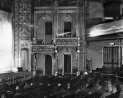
- Ben-Hur played for six months at the Million Dollar Theater.[citation needed]
Southeast corner of Third and Broadway
-
 View fromPan American Loftshad not yet been built on the NW corner of 3rd & Broadway. Around 1894–5.
 -
![Bradbury Building in 1894, then anchoring the southwestern end of the business district[48]](//upload.wikimedia.org/wikipedia/commons/thumb/7/72/Bradbury_Building_1894.jpg/435px-Bradbury_Building_1894.jpg) Bradbury Building in 1894, then anchoring the southwestern end of the business district[48]
Bradbury Building in 1894, then anchoring the southwestern end of the business district[48] -
 Bradbury Building in 1960
 -
 Bradbury Building exterior, 2005
 -
 Atrium of the Bradbury Building

![Bradbury Building in 1894, then anchoring the southwestern end of the business district[48]](/File:Bradbury_Building_1894.jpg)


- Lewis Bradbury. It is famous for its light-filled atrium, open cage elevators, marble stairways and ornate iron railings, and has appeared in many films including Blade Runner.[47]
Spring Street
Gallery
-
 Looking northeast on Spring Street from First Street, 1880s.Baker Blockare visible in the distance.
 -
 Looking northeast on Spring Street from First Street, 1890s. Hamburger's Peoples Store now in thePhillips Blockat center. Electric streetcars replaced horsecars and the street is paved. Today, this is the site of City Hall.
 -
 View south on Spring St. from Temple, c.1883–1894. The towers in the background are thePhillips Block; the two larger buildings to its right are the Jones Block and (with turrets) City of Paris. Far right: Allen Block and Harris & Frank's London Clothing Co., with its landmark clock.


West side of Spring south of Temple
-
 International Savings & Exchange Bank Building (1907) SW corner of Temple/Spring
 -
 Replica of the Int'l Savings Building façade in the film Safety Last!
 -
 City of Paris department store, north of Phillips Block and south of Temple, sometime between 1883–1890. Note the cable car which ran 1885–1902.
 -
 Jones Block, 171–201 N. Spring, west side across from Market St., southern building, c.1880-1885
 -
 Pound Cake Hillat back.
 -
 Jones Block sometime between 1886–1895 when home to J. W. Robinson'sBoston Dry Goods store.


Along the west side of Spring Street were the following buildings. Spring was realigned in the 1920s and now runs west of these sites, and the sites where these buildings once stood are now part of the full city block on which City Hall stands:
- At the southwest corner of Spring and Temple was the Allen Block, between 1883 and 1894 location of Harris & Frank's London Clothing Co., with its landmark clock. The first J. W. Robinson's Boston Dry Goods store was also located in this block from 1883–1886 before moving to the Jones Block slightly south.[49] The Allen Block was replaced by the International Savings & Exchange Bank Building (10 floors, 1907, H. Alban Reaves, Renaissance Revival and Italianate, demolished 1954-5)[50]), southwest corner of Temple and Spring. A replica of its façade featured in the Harold Lloyd film Safety Last!, in a famous scene where Lloyd hangs off a clock near the building's roof. In its later years it housed city health offices and was called the "Old City Health Building".[50]
- City of Paris department store, 203–7 N. Spring, west side between Temple and the Phillips Block. Spring Street now runs west of this site, which is part of City Hall.
- Jones Block, pre-1890 numbering 71–73 and 77–79–101–103 N. Spring;[51] post-1890 numbering 171–173–175–177–179–201 N. Spring St.,[52] home to:
- Los Angeles Herald steam printing plant until 1888[51]
- Preuss & Pironi drugstore c.1885-6[53]
- J. W. Robinson's Boston Dry Goods at #171–173 from 1886 to 1895. Robinson's would become a major department store chain across Southern California.
- City of Paris department store at #177 during its final few years of operation, c.1895–1897.[54] even as
Phillips Block
-
 Phillips Block
 -
 Entrance toPhillips Block1888–1908.
 -
 Phillips Blockabout 1900
 -
Looking north on Spring St. from First Street, 1890s with view of thePhillips Block.
-
 View north on Spring St. from First Street. Phillips Block visible in background, Harris & Frank's London Clothing Company at the SW corner of Franklin/Spring.


At the northwest corner of Franklin and Spring stood two buildings in succession, the Rocha Adobe, then the Phillips Block. The site now lies under the current course of Spring Street, which was straightened, i.e. realigned to run further west, in the 1920s.
- The Rocha Adobe (built 1820 as a residence for Antous Jose Rocha), 31–33 Spring Street (pre-1890 numbering), which from 1853–1884 served as the City Hall, and a building in the yard behind it served as the city and county jail.[55] It was demolished and in its place was built:
- Phillips Block (four-and-a-half stories, opened in 1888, Burgess J. Reeve, French Renaissance Revival architecture), 25–37 N. Spring St. (pre-1890 numbering) at the northwest corner of Franklin St., backing up to New High Street to the west. Owned by Pomona Valley rancher Louis Phillips, it cost $260,000. There was 120 feet (37 m) of frontage on Spring Street, 218 feet (66 m) on Franklin, and 121 feet (37 m) along New High Street. This building was the second four-story structure in Los Angeles. It was sometimes called Phillips Block No. 1 (there was a "Phillips Block No. 2" at 135–145 Los Angeles Street, on the west side between Market and First streets).[56] In July 1888, Asher Hamburger opened the Peoples Store here, later known as Hamburger's; it became the largest retail store in the Western United States. In 1908 it moved to 8th and Broadway, and in 1923 Hamburger sold it to May Co. and it became May Company California.[57] The Phillips Block was demolished in the mid-1920s to make way for the realigned Spring Street and today's City Hall.
Franklin to First
At the southwest corner of Franklin Street from 1894–1905 was Harris & Frank's London Clothing Co. with its landmark clock.[58][59] Harris & Frank went on to become a chain of junior department stores for men's clothing across the region.
East side of Spring south of Temple
Temple Block
-
 Looking south on Main St. towards Temple Block with Adolph Portugal dry goods store, mid-1870s
 -
 Further north on Main St., looking south towards Temple Block, mid-1870s
 -
 Temple Block c.1885.Courthouse clocktowervisible immediately behind Temple Block. Main St. (l), Spring St. (r)
 -
 Spring St. side of Temple Block, sign for Cohn Bros. store, mid-1890s.
 -
 NE portion of Temple Block at SW corner of Temple (r) and Main (l), 1924
 -
 Eastern side of Temple Block, looking north along the west side of Main Street towards Temple St. (r), 1924
_crop.jpg)
.png)


The triangular space where Spring and Main Streets came together at the south side of Temple Street was the site of Temple Block: actually a collection of different structures that occupied the block bounded by Spring, Main and Temple. The first or Old Temple Block built by
In 1925-7 this block and other surrounding areas were demolished to make way for the current Los Angeles City Hall.
Along the south side of Temple Block was Market Street, a small street running between Spring and Main.
Clocktower Courthouse/Bullard Block
-
 Clocktower Courthouse viewed from Fort Hill (from the west)
 -
 View from Spring St. of Clocktower Courthouse (r), southside of Temple Block (l),United States Hotel(back)
 -
 Clocktower (Temple) Courthouse, Market and Theater
 -
 Clocktower Courthouse, view from Spring St. looking SE, with theVienna Buffeton Court St. visible
 -
 Clocktower Courthouse
 -
 Bullard Block c.1900. It replaced the Clocktower Courthouse in 1895.
_Courthouse,_Market_and_Theater_view_from_west.png)
_Courthouse,_Market_and_Theater_(r),_Temple_Block_(l).jpg)
_Courthouse,_Market_and_Theater_1.jpg)
_Courthouse,_Market_and_Theater_2.jpg)
_Courthouse,_Market_and_Theater_4.jpg)

Taking up the small block immediately south of Temple Block between Market and Court streets, facing both Spring and Main streets, were two buildings in succession:
- Clock Tower Courthouse: Just south of Temple Block across tiny Market Street was a building known by many names including Temple Courthouse, Temple Market, Temple Theater, Old County Courthouse, etc. Also built by John Temple, in 1858, originally as a market (ground floor) and theater (upper floor). Demolished 1890s.[65][66] Served as a market and retail as well as the County Courthouse 1861-1891 until the Red Sand Courthouse was finished.[67] Topped by a rectangular tower with a clock on all four sides.[68][69] The Clock Tower Courthouse was demolished in 1895 and replaced by:
- Bullard Block, built in 1895-6, architects Morgan & Walls,[70] 154–160 N. Spring, NE corner of Court Street. Replaced the Clocktower Courthouse. Housed The Hub Clothing Co., a large department store for apparel. See also the photo below of "La Fiesta". Demolished 1925-6 to make way for current Los Angeles City Hall.[71]
Court south to First
-
 Vienna Buffet, which played a role in the city's LGBTQ history, seen sometime between 1891–1902
 -
 The "palatial" Jacoby Bros. store, 128–134 N. Spring Street, around 1896


- Court Street, a small street running between Spring and Main. At 12-14-16 Court Street (pre-1890 numbering). 112–116 Court St. (post 1890 numbering) was the Tivoli Theatre which opened and closed in 1890, lasting less than a year. From 1891 through 1902, the venue was the (New) Vienna Buffet, a restaurant with live music where scandal occurred, and gatherings of gay men including what were then called "she boys".[72] Then from 1902–c.1910, the site was the Cineograph Theatre, a vaudeville venue. From 1918–1925 it was marked the Chinese Theatre with the Sun Jung Wah Co. performing Chinese plays.[73]
- Jacoby Bros. dry goods store was located at 128–134 N. Spring St. from 1891-1900, and added the Jevne premises in 1896 (thus encompassing all of 128 through 138 N. Spring). The store moved to Broadway south of 3rd St. in 1900,[76][77] another signal that the upscale shopping district was moving southwest away from this area at that time.
First and Spring
-
-
 View north on Spring St. from First Street. Los Angeles National Bank building in foreground, right. Larronde Block in foreground, left. Phillips Block visible in background. Note the electric streetcar to Grand Ave.
.jpg)
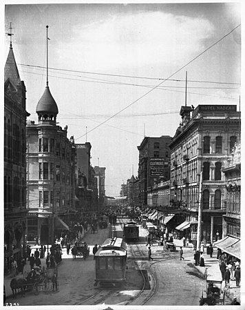
The image at above left looks south past the intersection of First and Spring sometime around 1900–1906. The spire of the Wilson Block is prominent on the left, as is the Nadeau Hotel on the right. In the foreground we can see the Los Angeles National Bank to the left and the Larronde Block to the right. From First to Second streets, Spring Street is still a busy shopping district, though Broadway is also just becoming popular for more upscale shopping. An electric streetcar heads to Griffin Avenue in
Northwest corner of First and Spring
-
![Larronde Block in 1898. Photo by I. W. Taber[78]](//upload.wikimedia.org/wikipedia/commons/thumb/9/9d/Larronde_Block_1898.png/474px-Larronde_Block_1898.png) Larronde Block in 1898. Photo by I. W. Taber[78]
Larronde Block in 1898. Photo by I. W. Taber[78] -
 Larronde Block, undated photo, probably 1910s
 -
 NW corner of 1st/Spring, 2020, an empty lot. Back right: County Courthouse (1972)
![Larronde Block in 1898. Photo by I. W. Taber[78]](/File:Larronde_Block_1898.png)


- Larronde Block, built in 1882 at a cost of $10,000,[79] 211 W. 1st St., also 101–105 N. Spring, two stories,[78] offices and retail shops, including:
- Mullen & Bluett, a major clothing store, 101–105 N. Spring,[80] from its founding in 1889 through 1910.[81]
- California State Building (completed 1931, opened 1932, architect John C. Austin, 1931, demolished 1976).[82]
- The lot is currently vacant
Northeast corner of First and Spring
-
 The east side of Spring Street, north of First, during theBullard Blockis in the distance at the top, center left.
 -
 Los Angeles National Bank Building
 -
 Equitable Savings Bank Building
 -
 North side of First Street between Spring and Main streets. Widney Block. c.1888
.jpg)


- Los Angeles National Bank Building (1887-1906), demolished and replaced by the
- Equitable Building (Equitable Savings Bank, 1906-1920s)[83]
First Street from Spring to Main
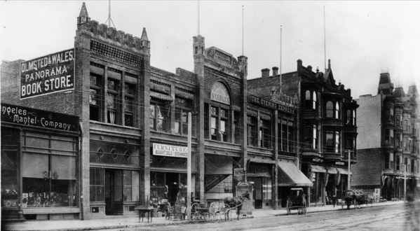
First Street east of Spring: Widney Block (i.e. Joseph Widney), built in 1883, along the north side. The main Olmsted & Wales bookstore was located in the block in the mid-1880s.
Southwest corner of First and Spring
-
 Nadeau Block housing the Nadeau Hotel (1882–1932)
 -
 L.A. Times Building, opened 1935, view in 2006.
.jpg)

- Nadeau Block or Nadeau Hotel, built 1881-2, demolished 1932, designed by architects Kysor & Morgan, located at the southwest corner of Spring and First streets. It was the first four-story building in the city.[84]
- This corner is now the site of the Los Angeles Times Building, opened 1935, part of the Times Mirror Square complex taking up the entire block between Spring, Broadway, First and Second streets, formerly the headquarters of the Los Angeles Times, currently vacant.
Southeast corner of First and Spring
-
 Wilson Block in 1920
 -
 The c.1927 two -story commercial block with the Security Pacific branch, seen from the City Hall tower
 -
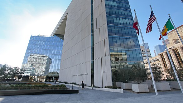 The 2009 L.A.P.D. Headquarters Building


Four buildings have stood here in succession:
- The George S. Wilson homestead[85]
- Wilson Block, sometimes called the city's first skyscraper.[86] Built 1886-8. Demolished around 1927.[87] The corner is now occupied by the Los Angeles Police Department Headquarters Building, completed in 2009.[88] The site is now home to:
- A replacement two-story retail building,Security Pacific National Bank, then the Security Trust and Savings Bank. (the Equitable Building was across the street to the north).[89]
- Since 2009, the Police Headquarters Buildingtaking up the entire block between First, Second, Spring and Main streets.
Second and Spring
Northwest corner of Second and Spring
-
 Bryson or Bryson-Bonebrake Block or Building erected 1886-8, photo 1905
 -
 The 1948 "Crawford Addition" building at Times Mirror Square, NW corner of 2nd & Spring, September 2020
.jpg)

- The Bryson Block, also known as the Bryson-Bonebrake Block or Bryson Bonebrake Building, northwest corner 2nd and Spring, constructed 1886-1888 for $224,000 on the site of a public school and an early city hall, as a 126-room bank and office building. Pacific Coast Architecture Database states it was "nothing short of amazing, displaying a riotous and eclectic amalgam of features". Built for mayor John Bryson and Major George H. Bonebrake, President of the Los Angeles National Bank and the State Loan & Trust Co.[90] Desmond's department store was located here from 1890 to 1900.[61]
It was replaced by the 1948 Crawford Addition building, part of the Times Mirror Square complex, currently vacant.
Northeast corner of Second and Spring
-
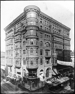
 1902 photo of the Burdick Block, on the NE corner of 2nd & Spring, built 1888; top floors added 1900.
 -
 L.A.P.D. Headquarters, opened 2012, NE corner of 2nd & Spring.


- Burdick Block, a.k.a. the Trust Building, 127 W. 2nd St., 1888 (Jasper Newton Preston), top stories added 1900 (John Parkinson). In 1910, refitted and rechristened the American Bank Building. Now site of the Los Angeles Police Department Headquarters which occupies the entire block from First to Second and from Spring to Main, completed 2009.[91][92]
Southwest corner of Second and Spring
-
 View west on 2nd at Spring. Hollenbeck Block (left) when it was only two stories, noteCoulter's store; 2nd City Hall (right), 1886
 -
 View south on Spring at 2nd, Hollenbeck Block when it was two stories, Coulter's store, 1886
 -
 Hollenbeck Block (1884-1933), SW corner of 2nd & Spring. c.1900-1905.
 -
 Historic Broadway station under construction, September 2020
,_2nd_City_Hall_(right),_1886.jpg)

.jpg)

- The Hollenbeck Block was located on the southwest corner of Spring and Second streets. It was built in 1884 by Hollenbeck Hotel and, on the corner, from 1884–1898, Coulter's 6,000 sq ft (560 m2) store, which would become a leading Los Angeles department store. Built 1884, demolished in 1933. Architect Robert Brown Young.[93] Currently the construction site of Historic Broadway station, an underground station of the Los Angeles Metro Raillight rail subway.
Southeast corner of Second and Spring
-
 Wilcox Building, built 1895-6, photo from 1905
 -
 The Wilcox Building in September 2020
.jpg)

- Wilcox Building, built 1895-6, architects Pissis and Moore, five stories. All but the ground floor were removed in 1971 after damage from the Southwestern School of Law was on its top floors 1915–1924.[94]
200 block
-
 Music (Turnverein) Hall (l) and Los Angeles (Lyceum) Theatre (r). West side of Spring between 2nd and 3rd, 1895.
 -
 Looking north on Spring from 3rd St., 1905
 -
 Looking south on Spring between 2nd and 3rd, c.1905. In the background at center: towers of theDouglas Building, Woollacott Block, Anheuser restaurant, Hamilton Bros. shoe store block, and portion of the Turnverein Hall
 -
 Workman Block, 232–234 S. Spring, photo c.1900-1906


On the west side:
- #217 (pre-1890 numbering: #119), the Parisian Cloak and Suit Co., 1888–1892; then 221 S. Spring until 1899. One of the city's prominent retailers of women's clothing during that era.
Two theatres together called the Perry Buildings:
- at #225–9 was the Lyceum Theatre, opened in 1888 as the Los Angeles Theatre (not to be confused with the Palace Theatre on Broadway. [95]
- at #231–5 was the Turnverein Hall (opened 1879), a theatre, renamed the Music Hall in 1894, Elks Hall in the early 1900s and Lyceum Hall in 1915. Demolished.[96]
- #237–241, Hamilton Bros. block, Hamilton Bros. shoe store at #239.[97]
- #243, Anheuser-Busch saloon, later known as The Anheuser Restaurant.[98]
- #245–7, Woollacott Block[97]
On the east side:
- Stowell Block at #224–228. In 1894 the Los Angeles Athletic Club was located here from 1893 until 1895.[99][100]
- Workman Block at #230–234. 232–234 were home to Parmelee-Dohrmann from 1899 through 1906. It was the city's premier store for china, crystal and silver, as well as — at that time — selling appliances like stoves and refrigerators. In 1906, the store moved to the 5th and Broadway area.[101]
Third and Spring
-
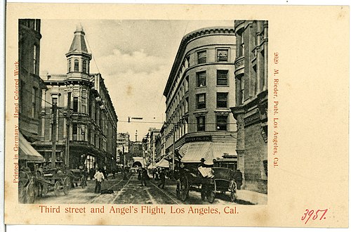 1903, looking west on Third past Spring:Angel's Flight at 3rd and Hill.
 -
 Douglas Building (1899– ), NW corner
 -
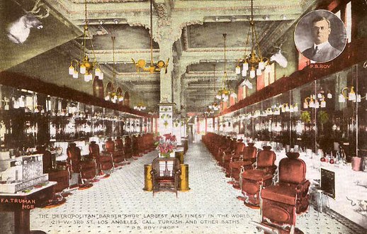 Metropolitan Barber Shop, 215 W. 3rd (demolished)
 -
 Stimson Block, NE corner (1893–1963)
 -
 Stimson Block in the mid-20th century
 -
 Hotel Ramona, SW corner (1885–1903)
 -
 Washington Bldg. (1912) at SW corner
 -
 Lankershim Building (1896–1959), SE corner
 -
 Ronald Reagan State Office Bldg. occupies the SE corner of 3rd & Spring today. Spring runs along its right side; this view looks south on Main St.


Northwest corner of Third and Spring
- Hammel and Denker Block (opened 1890, demolished 1899);Henry Hammel and Andrew H. Denker were business partners in hotels and ranching. Thomas Douglas Stimson bought it in 1893, thus owning two buildings at this intersection: this one and the Stimson Block (see below). Leading dry goods retailer Frank, Grey & Co. opened here in 1890[103] and the store was later taken bought by, and turned into a branch of J. M. Hale.[104]
- The Hammel & Denker Block was demolished and replaced by the Douglas Block in 1899 and still standing, now condos.[105]
- To the west of the Douglas Block stood the Metropolitan Barber Shop, originally at 214 W. 3rd, in 1908 it moved to 215-9 W. 3rd. The Los Angeles Herald claimed it to be the largest barber shop in the world at that time and the most expensive ever constructed, with 30 chairs, chandeliers and mahogany furnishings.[106]
Northeast corner of Third and Spring
- Stimson Block or Stimson Building, built 1893, architect Carroll H. Brown (also designed the Stimson House), demolished 1963. The city's tallest building when it opened. Built for lumber magnate Thomas Douglas Stimson. Now site of a parking lot.[107]
Southwest corner of Third and Spring
- The Callaghan Block or Ramona Block housing the Hotel Ramona, (1885,
Southeast corner of Third and Spring
- Site of the Lankershim Building (1896-7, Robert Brown Young, demolished 1959).[111] Now the site of the Ronald Reagan State Building.
Main Street
-
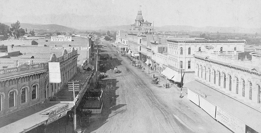 Main Street looking north from Temple, photo by T.E. Stanton, 1886. TheBaker Blockis the prominent building towards the back. Left side: Cosmopolitan Hotel, Farmers and Merchants Bank , Downey Block with Commercial Restaurant.

Main from Plaza south to Arcadia
Gallery (west side)
-
 Sentous Blocka.k.a Sentous Building, 1920
 -

-
 Vickrey-Brunswig Building
 -
 Plaza House
.png)
_(cropped).jpg)


Gallery (east side)
-
 Pico House in 1875
 -
 Pico House and the Plaza in 1876, photo taken from Fort Moore
 -
 Pico House today
 -
 Pico House, Merced Theater and Masonic Hall


Pico House
Pico House was a luxury hotel built in 1870 by
Masonic Hall
Masonic Hall at 416 N. Main St., was built in 1858 as Lodge 42 of the Free and Accepted Masons. The building was a painted brick structure with a symbolic "Masonic eye" below the parapet. In 1868, the Masons moved to larger quarters further south. Afterward, the building was used for many purposes, including a pawn shop and boarding house. It is the oldest building in Los Angeles south of the Plaza.
Merced Theater
The Merced Theater, completed in 1870, was built in an Italianate style and operated as a live theatre from 1871 to 1876. When the Woods Opera House opened nearby in 1876, the Merced ceased being the city's leading theatre.[112] Eventually, it gained an "unenviable reputation" because of "the disreputable dances staged there, and was finally closed by the authorities."[113]
Plaza House
This two-story building at 507–511 N. Main St. houses part of the
Vickrey-Brunswig Building
This five-story brick building facing the Plaza at 501 N. Main St. houses
Site of Sentous Building
The Sentous Block or Sentous Building (19th c., demolished late 1950s) was located at 615-9 N Main St., with a back entrance on 616-620 North Spring St. (previously called Upper Main St., then San Fernando St.). Designed in 1886 by Burgess J. Reeve. Louis Sentous was a French pioneer in the early days of Los Angeles.[117] The San Fernando Theatre was located here. The site is now part of the El Pueblo parking lot.[118][119]
West side of Main from Republic south to Temple
-
 St. Elmo (orig. Lafayette) Hotel circa 1890

This block is part of the site of the current Spring Street Courthouse. Buildings previously located here include:
- Lafayette Hotel, 343 N. Main, opened in the 1850s, c. 1882 renamed the Cosmopolitan Hotel, then the St. Elmo Hotel.[120] Razed in 1933.[121]
Northwest corner of Temple and Main
-
 View to the NW of Old Downey Block, c. 1870, before Downey Block was built in 1871: "Harris & Jacoby", forerunners to Harris & Frank and Jacoby Bros., and M. Kremer, forerunner of the City of Paris, the city's first department store
 -
 South end of the Downey Block, at the NW corner of Temple/Main, 1880s
 -
 North end of the Downey Block along the west side of Main St., 1887. Temple Block at left; Spring Street runs towards thePhillips Block(tower) in the background at center-left.
 -
 1910 Post Office and Courthousewhich replaced the Downey Block NW corner Temple and Main
 -
 The 1940Spring Street Courthouse, NW corner Temple/Main, 2008


On this corner stood four buildings in succession, the first two of which had a key role in the history of retail in Southern California, as it was home to a number of upscale retailers who would later grow to be big names in the city, and some, regional chains.
- Old Downey Block (?-1871), northwest corner of Temple and Main, Replaced by the Downey Block (1871-1910). Retailers that got their start here included Harris & Jacoby,[124][125] forerunners to the Harris & Frank clothing chain and the large Jacoby Bros. department store; and M. Kremer,[126] forerunner of the Los Angeles City of Paris.
- Downey Block (1871–1910), replaced by the New Post Office in 1910. Retailers who were located here included Coulter's (1878-9),[127] Jacoby Bros. (1878-9),[128] and Quincy Hall (1876–1882),[129] forerunner of Harris & Frank.
- New Post Office also known as the Spring Street Courthouse, opened in 1940.[130]
- Spring Street Courthouse, opened in 1940.[130]
East side of Main from Arcadia south to Commercial
Baker Block
-
 Abel Sterns adobe c. 1857. Built in 1835-8, demolished in 1877 to make way for the Baker Block
 -
 Baker Block, built 1878, demolished 1942, site now underUS 101freeway. Photo c. 1880
 -
 Lithograph of the Baker Block
.jpg)


- Baker Block, 334–348** N. Main at the southeast corner of Arcadia Street, opened late 1878, Second Empire architecture. The Baker Block was erected on the site of Don Abel Stearns' adobe mansion also called El Palacio, built in 1835-1838 and demolished in August and September of 1877;[131] Col. Robert S. Baker who had the Baker Block built, had married Stearns' widow, Arcadia Bandini de Stearns Baker. When built, it was called the "finest emporium of commerce south of San Francisco". The ground floor housed retail tenants such as Coulter's (1879–1884), George D. Rowan and Eugene Germain. The second floor was offices, and the third floor held the city's most upscale apartments. In 1919, Goodwill Industries bought the building and opened its store and operations. That is not to say though, that nobody fought to save the building. The Metropolitan Garden Association tried to move the Baker Block to another location for use as a public recreation center, while city councilman Arthur E. Briggs raised funds to convert the building into a city history museum. Nonetheless, in 1941, Goodwill sold the building to the city, which demolished it in 1942. Currently, the US 101 freeway, and the new, more southerly route of Arcadia Street, run over most of the site.[132]
South of Baker Block
-
 c. late 1870s: Grand Central Hotel branded as part of the St. Charles, Bank of Los Angeles in the Pico Bldg., St. Charles hotel proper, 312 bldg. and L. Harris store, forerunner of Harris & Frank
 -
 Sketch of east side of the 300 block of North Main Street, between Arcadia and Commercial streets, as it appeared circa 1880
 -
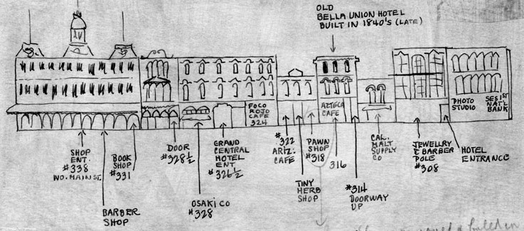
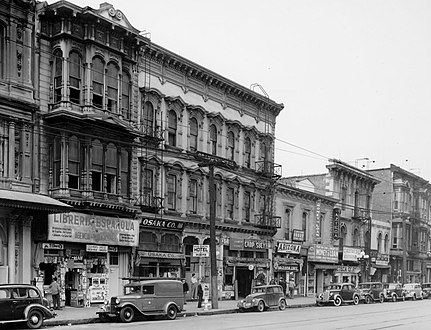 Downey ("Libería Española"), Grand Central ("Osaka Co.", "Chop Suey"), Pico ("Arizona Cafe", "Money to Loan"), Bella Union/St Charles ("Azteca"), 312 and 306-8 buildings, 1930s.
 -
 2005 view. Main St. runs along the left (west) side from the Plaza area (top left), over US 101 (site of the Baker Block) and along the western edge of the Los Angeles Mall (bottom center), site of the buildings described below (Downey Building through Ducommun Block).


South of the Baker Block stood buildings that are now the site of the northwestern-most part of the Los Angeles Mall:
- Downey Building (not to be confused with the "Downey Block"), 324–330** N. Main, opened 1878, three stories, captured in a 1957 color photo standing alone as the last building on the block, demolished that year.[133] In the 1930s photo above, it is home to the Librería Española.
- Grand Central Hotel, opened 1876, demolished.
- Pico Building, 318-322** N. Main, opened 1867, the city’s first bank building, to house the new Security Pacific National Bank. Later tenants included the Los Angeles County Bank (1874-1878), Charles H. Bush, jeweler and watchmaker (1878-1905), Louis E. Pearlson’s jewelry, loan and pawnshop (from 1905), as well as several barber shops and then a succession of owner-operated restaurants. The last occupants were a jewelers and the Mexican restaurant Arizona Cafe #2. Demolished 1957 to make way for a parking lot.[134]
- Bella Union Hotel, later the St. Charles Hotel, 314–316** N. Main. Opened 1835, demolished 1940. Home to the Azteca Cafe in the 1930s.
- 312 N. Main, two stories, home to a saloon in the mid-1890s
- 306–308 N. Main, three stories, home to offices (at #308) and Bright's Cheap Store (#306) in 1882.[135]
- Ducommun Block or Ducommun Building, 300-2-4** N. Main (200-2-4* N. Main). In the 1880s, home to the Ducommun hardware store, a furniture store and Prager Dry Goods. In the early 20th century, site of the
The Los Angeles Mall replaced these blocks; it is a small shopping center at the Los Angeles Civic Center, between Main and Los Angeles Streets on the north and south sides of Temple Street, connected by both a pedestrian bridge and a tunnel. It features Joseph Young's sculpture Triforium, with 1,500 blown-glass prisms synchronized to an electronic glass bell carillon. The mall opened in 1974 and includes a four-level parking garage with 2,400 spaces.
East side of Main from Commercial south to First
-
 The 1888 New Lanfranco Block, early 1920s
 -
 Main and Requena:United States Hotel right, Victorian 200–202 N. Main at left (Southern Pacificticket office in 1888)
 -
 United States Hotel, SE corner Requena/Main. c. 1880
 -
 Triforium sculpture at the Los Angeles Mall just N of the NE corner of 1st/Temple, 2018.


Currently, this site is the southernmost end of the Los Angeles Mall; Triforium is approximately on the site of Commercial Street.[138]
- #240 Farmers and Merchants Bank was located here in 1896[138]
- #236 Los Angeles Savings Bank was located here in 1896[138]
- #226-8 Commercial Bank, renamed First National Bank in 1880, was located here in 1896.[139]First National Bank was located here in 1896.[138]
- #214–222 (pre-1890 numbering: 74): New Lanfranco Block, built 1888, architects
- #200–202 (NE corner of Requena) Southern Pacific ticket office as of 1888-9[142]
- #158–172: United States Hotel, southeast corner of Main and Requena St. (a.k.a. Market St.). Built 1861-2, demolished 1939. When built it was one of three hotels in the city, alongside the Bella Union and the Lafayette Hotel. It was ornate and Italianate in style, with a "profusion of brackets, corbel tables and oriel windows. On one end, a tower with a mansard roof lit by l'oeil de boeuf windows, poked up another story to signal the hotel's location to travelers.”[143] Today, location of the south plaza of the Los Angeles Mall.
West side of Main from Temple south to First
-
 Illich's Restaurant ad from March 1890

This block is, since 1928, the site of Los Angeles City Hall
- Before 1926, Spring Street and Main Street met at Temple Street. From Temple, Main and Spring streets proceeded south; Spring at a more southwesterly angle. This created a narrow triangle with the triangle's northern point at Temple. Proceeding south along Main on the right-hand side one would pass the east side of Temple Block.
- Junction with Market Street
- Clock Tower Courthouse until demolished in 1895, or the Bullard Block built in its place after 1895.
- Junction with Court Street
- Illich's Restaurant and Oyster Parlors, 41–43 (pre-1890 numbering) 145–7 (post-1890) N. Main St.. Starting in the 1870s as a small chophouse, Illich's grew to be the largest restaurant in the city. Owner Jerry Illich was born in Dalmatia. He was connected with the Maison Doree restaurant at 4th and Main and later opened his own restaurant in 1896 on west 2nd Street between Broadway and Hill.[144]
- Northwest corner of First and Main streets.
East side of Main from First to Second
-
 TwoBaker Block.
 -
 Grand Opera House, 110 S. Main, c. 1884–1893
 -
 Orpheum Theatre when located at the Grand Opera House building, c. 1898
 -
 Forster Block


- Grand Opera House (1884, demolished 1936, capacity c. 1,300–1,800), 110 S. Main, in later years known as the Orpheum (Dec. 1894–Sep. 1903), Clune's Grand (c. 1912), The Grand (c. 1920s), and Teatro México (1930s). (The Palace Theatre). This theater was the site of the first commercial showing of motion pictures in the city, when on July 6, 1896, several films from the Edison Studios were projected by Billy Porter, who would later become a famous silent film director. Appeared in the film in Busby Berkeley's Bright Lights (1st National/Warner Bros, 1935). Demolished in 1936 to make way for a parking lot.[145]
- Forster Block, 122–128 S. Main St. (post-1890 numbering), 22–28 S. Main St. (per-1890 numbering), was a two-story building built in the early 1880s, five doors south of the Grand Opera House. It housed a coffee house of the Women's Christian Temperance Union at #26, heavily damaged in an 1885 fire, and a saddlery.[146]
Third from Spring to Main, Third and Main
-
 c. 1887 view looking east along south side of 3rd Street incl. former New York Brewery, towards Main (across top). Back left: The Thom Block. Back right: Olmsted & Wales bookstore in thePanorama Building.
 -
 Hotel Westminsterat the NE corner of 4th/Main.
._Back_left_The_Thom_Block._Back_right_-_Olmsted_%26_Wales_bookstore_in_Panorama_Building.jpg)
_and_4th,_c.1890.png)
On the corner of Third and Main:[147]
- Wells Fargo and Co. offices, northwest corner of 3rd/Main as of 1894
- The Thom Block, southeast corner of Mayo/Third and Main as of 1894
- Schwartz Block and Jackson House, southwest corner of 3rd/Main as of 1894
Buildings along Los Angeles Street
-
 Old Chinatownstretched from Sanchez Street across Los Angeles Street to what is now Union Station. c.1885.
 -
 Lugo Adobe lining the eastern edge of Los Angeles Plaza. The street in front of the adobe was part of Los Angeles St. starting in the 1880s.
 -
 Chinese American Museum in the Garnier Building
 -
 1882 view, looking north from Broad Place alongCoronel Adobe(SE corner of Arcadia). A few years later, both adobes would be demolished and Los Angeles St. would be extended northward to (and past) the Plaza.
 -
 Looking east on Arcadia towards houses lining the east side of Broad Place. Aliso Street runs form their right side towards the background.Coronel Adobeis at left.
 -
 Adobes inCalle de los Negros
 -
 Broad Place at north end of Los Angeles Street c.1870s. At back,Calle de los Negros(r)


,_Calle_de_los_Negros_(r).png)

Northern end of Los Angeles Street

The Coronel Adobe was demolished in 1888 and 1896 Sanborn maps show that the Del Valle adobe had been removed, and Los Angeles Street had been extended
Eastern edge of Plaza
Since the early 1950s, Los Angeles Street has formed the eastern edge of the Plaza, but the buildings lining its eastern edge, including the Lugo Adobe, were removed.[150][151] The site is now Father Serra Park.
From the Plaza north to Alameda

When it was extended past the Plaza in 1888,[148] Los Angeles Street terminated one short block north of the Plaza at Alameda Street. Now, Los Angeles Street turns east at the north side of the Plaza to terminate at Alameda Street at a right angle, directly across from the Union Station complex. What was the short block of Los Angeles Street north of the Plaza is now part of Placita Dolores, a small open plaza which surrounds a statue of Mexican charro entertainer Antonio Aguilar on horseback.[152]
Calle de los Negros
Until the late 19th century, Los Angeles Street did not form the east side of the Plaza; it ran south only from Broad Place at the intersection of Arcadia Street. Here, the Coronel Adobe blocked the path north one block to the Plaza, but just slightly to the right (east) of the path of Los Angeles Street was Calle de los Negros (Spanish-language name; marked on post-1847 maps as Negro Alley or Nigger Alley), a narrow, one-block north–south street likely named after darker-skinned Mexican
The neglected dirt alley was already associated with vice by the early 1850s, when a bordello and its owner both known as La Prietita (the dark-skinned lady) were active here. Its other businesses included malodorous livery stables, a pawn shop, a saloon, a theater and a connected restaurant. Historian James Miller Guinn wrote in 1896, "in the flush days of gold mining, from 1850 to 1856, it was the wickedest street on earth...In length it did not exceed 500 feet, but in wickedness, it was unlimited. On either side it was lined with saloons, gambling hells, dance houses and disreputable dives. It was a cosmopolitan street. Representatives of different races and many nations frequented it. Here the ignoble red man, crazed with aguardiente, fought his battles, the swarthy Sonorian plied his stealthy dagger, and the click of the revolver mingled with the clink of gold at the gaming table when some chivalric American felt that his word of “honah” had been impugned."[153]
By 1871, the alley was notorious as a "racially, spatially, and morally disorderly place", according to historian César López. It was here that a growing number of Chinese immigrant railroad laborers settled after the completion of the transcontinental railroad in 1869. There, William Estrada notes, the "Chinese of Los Angeles came to fill an important sector of the economy as entrepreneurs. Some became proprietors and employees of small hand laundries and restaurants; some were farmers and wholesale produce peddlers; others ran gambling establishments; and some occupied other areas left vacant by the absence of workers in the gold rush migration to California." The Chinese population increased from 14 in 1860 to almost 200 by 1870. Guinn stated that the alley stayed "wicked" through and after its transition to the city's Old Chinatown.[153]
Calle de los Negros was reconfigured in 1888 when Los Angeles Street was extended north, with a small, shallow row of houses remaining between the new section of Los Angeles street's eastern edge and the western edge of the new, shortened alley.[148][159] The site of Calle de los Negros is now the Pueblo parking lot and a cloverleaf-style entrance to the US 101 freeway.
Coronel Adobe
The Coronel Adobe was built in 1840 by
Garnier Building
At 419 N. Los Angeles Street, at the northwest corner of Arcadia, is the Garnier Building, built in 1890, part of the
-
 Haas, Baruch & Co., successor to Hellman, Haas & Co., SE corner of Aliso St. c.1890s
 -
 1885 view of the east side of Los Angeles St. with Bell Block at center with its two story porch, to its right Mellus Row, then Hellman, Haas & Co. At center is Aliso St. heading east (top center of photo).
 -
 West side of Los Angeles street from Arcadia to Commercial, 1890s. Hellman Block at left, Arcadia Block at right
 -
 Arcadia Block, 1870s. SW corner of Los Angeles and Arcadia streets.
 -
 Los Angeles St. north from 1st St. ca. 1910
 -
 Los Angeles St. north from 3rd St. ca. 1910
,_218-224_(now_318-324)_N._Los_Angeles_St._c.1890s.png)
.jpg)


.jpg)
.jpg)
Los Angeles Street was lined with mostly commercial buildings; the southeast end of the business district around Los Angeles and 3rd streets was the Wholesale District. Only a few buildings were notable:
West side south of Arcadia
- Arcadia Block: southwest corner of Arcadia Street. Built 1858, razed in 1927.[160]
- Hellman Block: in 1870, banker and University of Southern California founder Isaias W. Hellman erected the Hellman Block at the northwest corner of Los Angeles and Commercial streets.[161] This is one of several Hellman Blocks or Hellman Buildings in the city.
East side south of Aliso
- General John C. Fremont's headquarters and the first Los Angeles City Hall. Captain Alexander Bell and Mellus lived here (Francis Mellus married a niece of Mrs. Bell's). It was taken over by General Fremont for his headquarters and thus became the state capital for the short period of his acting as governor. The Los Angeles City organization was formed in this building in 1850.[162]
- Mellus Row, adjacent to Bell Block on the south
- Hellman, Haas & Co. grocers (a partnership of Abraham Haas and Herman W. Hellman), the predecessors of Smart & Final. Located in the 1880s and 1890s at 218-224 (pre-1890 numbering, post-1890 numbering: 318-324) N. Los Angeles St., adjacent to Mellus Row on the south.[163] Not to be confused with the Haas Building.
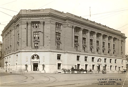
- Between Aliso and Temple streets on the east side of Los Angeles St. at #300 is the Federal Building, opened in 1965-6, architect Welton Becket.[164] Temple was extended east of Main Street between Aliso Street and a street that was known as both Requena and Market street. Adjacent and to its east is the Edward R. Roybal Federal Building and United States Courthouse, completed in 1992.
- Between Temple and First streets is Parker Center, the Los Angeles Police Department headquarters from 1955–2009
- At the southeast corner of First Street, New Otani Hotel.
Transportation
-
 Lithograph showing theBaker Blockand horse-drawn streetcar, c.1890
 -
 TheTemple Street Cable Railwaycar, 1890
 -
 "Red car" of the Pacific Electric
 -
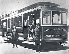
 A Los Angeles Railway electric streetcar, 1891
 -
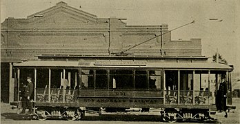
 Main Street & Agricultural Park electric streetcar, c.1896
 -
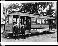 A Los Angeles Railway electric streetcar, c.1900-1910

_(14735748166).jpg)

.jpg)
Horsecars (1874–1897)
- Horse-drawn streetcars started with the Spring and Sixth Street Railroad in 1874. The last horsecars were converted to electric in 1897.[166][167]
Cable cars (1885–1902)
Electric streetcar systems (1887–1963)
Electrically-powered streetcar systems were numerous starting with the Los Angeles Electric Railway in 1887, but were over time consolidated into two large networks:
- In 1901, Henry Huntington bought various electric streetcar companies operating mostly within the City of Los Angeles (and not in the San Fernando Valley, Harbor area or Westside) and combined them into the Los Angeles Railway with its "yellow cars".
- In 1902, Huntington and banker Pacific Electric Railway, which would acquire other railways, providing interurban service to surrounding towns in what is now Greater Los Angeles (Los Angeles, Orange, San Bernardino and Riverside counties) and new suburban developments. The Pacific Electric Building, with station underneath, was opened in 1905 at 6th and Main Street.
Funiculars
Railroad depots
-
 Los Angeles & San Pedro Railroad Depot, SW corner Alameda and Commercial streets, c.1880
 -
 Los Angeles and Independence Railroad Depot, 5th & San Pedro streets, c.1875
 -
 Southern Pacific Railroad's Arcade Depot, Alameda between 5th/6th, c.1895-1900
 -
 Southern Pacific Railroadc.1918, Central & 5th streets, c.1918
 -
 La Grande Station of the Atchison, Topeka and Santa Fe Railway, Santa Fe and 2nd streets, c.1915
.jpg)
.jpg)
.jpg)
.jpg)

- Los Angeles & San Pedro Railroad Depot, SW corner Alameda and Commercial streets
- Los Angeles and Independence Railroad Depot, San Pedro and 5th street (southeast of the business district)
- Southern Pacific Railroad along Alameda Streetbetween 5th to 6th streets. Opened 1888, closed 1914.
- La Grande Station of the Atchison, Topeka and Santa Fe Railway, Santa Fe at 2nd (East of the business district), opened 1893, closed 1939
- Southern Pacific Railroad, Central and 5th streets (southeast of the business district), opened 1914. Union Pacific Railroad started operating from the station in 1924. Disused 1939.
- Union Station was opened in 1939, replacing the existing Central and La Grande stations.
Landmarks shown on schematic map
This is a map of the former and current buildings located in the Victorian business district of Los Angeles around 1890-1905.
Abbreviations and notes
- CH = Concert Hall
- "Female boarding" was a euphemism for small rooms, "cribs", used by prostitutes.[169]
- †(Dagger) indicates a street that no longer exists
To be read like a map:
| Temperance Temple (1888–1950s) Now L.A. County Heating and Refrigeration Plant. |
F O R T S T. / B R O A D W A Y |
B U E N A V I S T A S T. † |
N E W H I G H S T R E E T † |
- Lafayette Hotel /Cosmopolitan Hotel/ St. Elmo Hotel (1850s–?) -1st Downey Block (?–1871) 2nd Spring Street Courthouse (1940- ).
|
M A I N S T R E E T |
—Now US 101 Security Pacific Bank
Now Los Angeles Mall. |
—Now US-101 freeway. —Arcadia Block (1858–1927)/
|
L O S A N G E L E S S T R E E T |
Now US 101 —Bell Block —Mellus Row (Fremont HQ) —Hellman, Haas & Co. Now Federal Building (1965, Welton Becket) | ||||||
| COMMERCIAL ST.† | COMMERCIAL | ||||||||||||||
| Now Hall of Justice (1925) (N side of Temple from Broadway to Spring) |
—Farmers and Merchants Bank Now Los Angeles Mall |
||||||||||||||
| TEMPLE | TEMPLE | TEMPLE | |||||||||||||
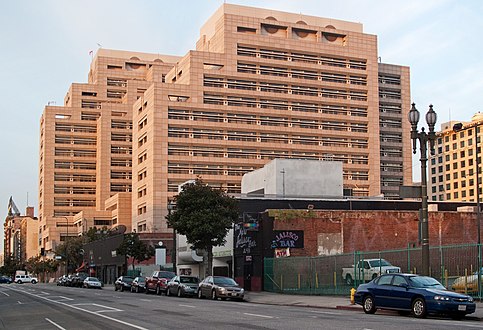
| High School (1873-1887)/ "Red Sandstone" Courthouse (1891-1936) Now L.A. County Courthouse (1972) |
Jones Block (J. W. Robinson's 1886–1895) Now part of City Hall site. |
S P R I N G S T R E E T |
Temple |
REQUENA ST. | (MARKET)† | ||||||||||
| United States Hotel (1861–1939) | Now City Hall East (1972) | Parker Center (former LAPD HQ) | |||||||||||||
| MARKET ST.† | |||||||||||||||
Court Flight Funicular (1905–1943)
|
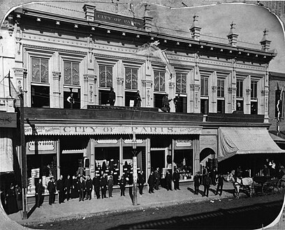
Hamburger's Peoples Store (1888–1908)
|
||||||||||||||
| Hall of Records (1911-1973) | COURT ST.† | Now Los Angeles Mall. (entire block) | |||||||||||||
| FRANKLIN ST.† |
—#128–138 Jacoby Bros. DS (1879–1900) |
—Hall of the Amigos del País (1844-?)/ |
German-American Savings Bank (1894–1906) | ||||||||||||
|
|
Los Angeles Times Building (#3, 1912-1938) Now vacant lot. |
Larronde Block (1892-c.1930)/ | |||||||||||||
| FIRST ST. | FIRST ST. | FIRST ST. | FIRST ST. | FIRST ST. | |||||||||||
| #107: Old Junípero Serra State Office Bldg. (1958–2006) U.S. Courthouse
("First Street Courthouse") (entire block, 2016) #127: Mason Opera House (1902-1956)[172] |
Culver Block/ Now Times Mirror Square Pereira building (1973). |
Nadeau Hotel (1882–1932)/Now Times Mirror Square Kaufmann building (1935). |
Wilson Block (1886–?) Now LAPD HQ |
Natick House (1883–1950 JP) Now LAPD HQ |
#110: Grand Opera House/
Now Caltrans |
Doubletree Hotel (ex-New Otani) (1977) Weller Court mall | |||||||||
| #128-130: Southwest Building (1903–?; Chamber of Commerce; The Herald) |
—Louis Roeder Block #1 —Bryson Block —Mueller's Block |
Now LAPD HQ (built 2009, entire block) | |||||||||||||
|
#141–145: Frost Bldg./ |
#138: Hellman Bldg. |
Bryson-Bonebrake |
—Corfu Hotel |
H. T. Newell Block (as of 1910, shops and offices) Now LAPD HQ | |||||||||||
| SECOND ST. | SECOND ST. | SECOND ST. | SECOND ST. | SECOND ST. | |||||||||||
| Broadway Media Center —American Natl./California Bank (1878-1911)/ 2nd Calif. Bank Bldg. (1911–?) —YMCA block (1889-1911)/ Merchants Trust Co. Bldg. (1910–?) |
Hollenbeck Hotel Nolan, Smith & Bridge Bldg. (#200–4) Now Historic Broadway station under construction. |
Wilcox Building (1895-6) |
Higgins Bldg. (1910) | Little Tokyo district | |||||||||||
| —#213–223 Potomac Block (1890–1953; from 1893–1905 Ville de Paris DS; from 1905–1917 Coulter's DS) –#237-241 J. W. Robinson's Boston Dry Goods (1895–1915) |
Now 213 S. Spring parking garage. –#206–10 Gordon Bldg. (New King Hotel) |
Now 213 S. Spring parking garage. —#227: 1st Los Angeles Theatre/ 2nd Orpheum Theatre/ Lyceum Theatre (1888–1941)[176] —#229 Turnverein (Lyceum) Hall (1894-1950s) —Douglas Building (1897) |
The Downtown Independent cinema
|
ex-Cathedral of Saint Vibiana (1876) | |||||||||||
| —#253: Irvine Byrne Block , 1895)
|
Rindge Bldg. (c.1901) | Metropolitan Barber Shop[177] | Stimson Bldg. (1893–1963) | Now misc. retail | Now parking garage. | ||||||||||
| THIRD ST. | THIRD ST. | THIRD ST. | THIRD ST. | THIRD ST. | |||||||||||
| Hotel Ramona (?-1903)/ Million Dollar Theatre (1917- )
|
Bradbury Building (1893) | Washington Bldg. (1912) | Reagan Bldg.
|
Wesley Roberts Bldg. Now Reagan Bldg.
|
Now parking lot. | ||||||||||
See also
References
- ^ "Early Los Angeles Historical Buildings (1800s)", Water and Power Associates
- ^ "Los Angeles Fifty Years Ago: The Re-Creation of a Vanished City". Los Angeles Times. November 15, 1931. p. 90. Archived from the original on June 7, 2019. Retrieved May 13, 2019 – via Newspapers.com.
- ^ "Fact and Comment". The Los Angeles Times. January 16, 1910. Archived from the original on October 31, 2023 – via Newspapers.com.
- ^ a b c search for the location, Google Maps, retrieved October 20, 2020
- ^ "Believes in North End". Los Angeles Times. January 16, 1910. p. 65.
- ^ "Map of Temple Street Cable Railway, via Metro (Los Angeles County)".
- ^ "Temple Street Cable Railway (1886)". www.erha.org.
- ^ "New Buildings: A Splendid Showing for the Future Los Angeles". Los Angeles Times. May 13, 1888. p. 3.
- ^ "Water and Power Associates".
- ^ "Los Angeles County Central Heating and Refrigeration Plant". Calisphere.
- ^ "Water and Power Associates". waterandpower.org.
- ^ "Water and Power Associates". waterandpower.org. Retrieved May 22, 2021.
- ^ "PCAD - Tajo Building, Downtown, Los Angeles, CA". pcad.lib.washington.edu.
- ^ "Water and Power Associates".
- ^ "BEgins New Era of Achievement: Chamber of Commerce Welcomes Public to Magnificent Home, with Brilliant Reception — Annual Reports Show Splendid Progress". The Los Angeles Times. February 13, 1904. p. 13. Retrieved November 10, 2020.
- ^ "PCAD - Los Angeles Chamber of Commerce Building, Downtown, Los Angeles, CA". pcad.lib.washington.edu.
- Pacific Coast Architecture Database
- ^ a b "New Los Angeles US Courthouse". www.gsa.gov.
- ^ "Mason Theatre in Los Angeles, CA - Cinema Treasures". cinematreasures.org.
- ^ "2nd Street and Broadway" Huntington Digital Library
- ^ Marques Vickers, Reinventing Broadway, p.52
- ^ "Water and Power Associates".
- ^ "Broadway to the Front". Los Angeles Evening Express. August 7, 1891. p. 8.
- ^ a b "Advertisement for City of Paris". Los Angeles Times. August 6, 1895. p. 10.
- ^ "Merchants Trust Company Building, ca.1910". Calisphere.
- ^ "Great Store for Coulter". Los Angeles Times. August 2, 1904. p. 13.
- ^ Hill, 224-6-8 S. (November 2, 1906). "Coulter's location 1906 225–229 S. Broadway". The Los Angeles Times. p. 19.
{{cite news}}: CS1 maint: numeric names: authors list (link) - ^ "Ad for Coulter's new store opening". Los Angeles Times. May 31, 1905.
- ^ a b "Potomac Block :: Los Angeles Public Library Photo Collection". tessa.lapl.org.
- ^ "Potomac Block. The Work of Building Up a Great City". Los Angeles Herald. July 18, 1890.
- ^ "Potomac Block & Bicknell Block – Romanesque Revival Downtown – PocketSights". pocketsights.com.
- ^ "Western Shoe Company – Western Department Store – 227 S Broadway". Los Angeles Evening Express. May 26, 1922. p. 14. Retrieved May 22, 2021.
- ^ "The Boston Dry Goods Store". Los Angeles Times. January 1, 1895. p. 29. Retrieved May 3, 2019.
- ^ "The New Boston Store:Los Angeles' Finest Commercial Structure Is Complete". Los Angeles Herald. October 4, 1895. p. 5.
- ^ "31 Dec 1898, 4 – Los Angeles Times at Newspapers.com". Newspapers.com.
- ^ a b "19 Jun 1904, 12 – Los Angeles Times at Newspapers.com". Newspapers.com.
- ^ Sanborn Map of Los Angeles: 1894, vol. 1, plate 8, via Library of Congress.
- ^ Sanborn Map of Los Angeles: 1906, vol. 2, plate 131, via Library of Congress.
- ^ a b Sanborn Maps of Los Angeles: 1894, vol. 1, plate 8; 1906, vol. 2, plate 131.
- ^ "Pig 'n Whistle opens 224 S. Broadway". The Los Angeles Times. December 10, 1908. p. 22 – via newspapers.com.
- ^ "CityDig: This Was L.A.'s City Hall for 39 Years". Los Angeles Magazine. May 8, 2014. Retrieved May 16, 2019.
- ^ Maese, Kathryn. "The Victor No Longer". Los Angeles Downtown News - The Voice of Downtown Los Angeles. Retrieved August 11, 2020.
- ^ "I Magnin moves from Spring to Broadway 1". Los Angeles Times. December 31, 1898. p. 4 – via newspapers.com.
- ^ Flynn, Kathleen Nye. "Mixing the Old With the New". Los Angeles Downtown News – The Voice of Downtown Los Angeles. Retrieved May 22, 2021.
- ^ "Business Property Deal: Nearly Two Hundred Thousand Dollars for a Good Corner". March 22, 1899.
- ^ "22 Sep 1989, 19 - The Los Angeles Times at Newspapers.com". Newspapers.com. Retrieved October 13, 2018.
- ^ a b "Bradbury Building | Los Angeles Conservancy". www.laconservancy.org.
- ^ "The Opening of North Broadway". Los Angeles Times. October 9, 1895. p. 6.
- ^ "Nine Acres Space in Robinson Store". Los Angeles Evening Express. May 30, 1914.
- ^ a b "Wreckers Put Hammer to Old Health Building". Los Angeles Times. December 30, 1954.
- ^ a b Sanborn 1888 map of Los Angeles, plate 18, via Los Angeles Public Library
- ^ Sanborn 1894 map of Los Angeles, plate 10 (east), via Library of Congress
- ^ "Beware of Counterfeits". The Los Angeles Times. April 29, 1885. p. 1. Retrieved November 12, 2020.
- ^ "City of Paris 1895 177 N Spring". Los Angeles Times. September 11, 1895. p. 4 – via newspapers.com.
- ^ "Rocha Adobe", Water and Power Associates
- ^ Stern, Norton B. "Louis Phillips of the Pomona Valley". Historical Society of Southern California: 184.
- ^ "Architect B. J. Reeve". San Francisco Examiner. August 14, 1887. p. 19. Retrieved May 13, 2019.
- ^ "Advertisement by London Clothing Co., Harris & Frank, proprietors". Los Angeles Herald. February 17, 1894. Retrieved May 6, 2019.
- ^ Block 10 as sown on Sanborn Fire Map, 1894
- ^ Israel, S. A. (January 3, 1926). "Historic Temple Block Surrenders to Progress after Seventy Years". Los Angeles Times. p. 71.
- ^ a b "Desmond's in Seventy-Sixth Year", Los Angeles Times, 21 Oct 1937, Page 8
- ^ "Concentrating: The Growth of a Business and a Great Bazaar: A Grand Rally of Wholesale and Retail: Outposts and Pickets Under One Large Roof: The Jacoby Bros. Occupy Their New and Magnificent Building and Receive the Congratulations of Their Many Friends". Los Angeles Times. November 14, 1891. p. 3.
- ^ Ad for Cohn Bros., [Los Angeles Herald]] May 14, 1892, p. 8
- ^ Ad for Cohn Bros. in Los Angeles Times, May 15, 1897
- ^ "Buildings and Lands. The July Permits Break the Record. The Remarkable Gains over Last Year's List". Los Angeles Express. August 3, 1895. p. 5.
- ^ "Bullard Block", Los Angeles Water & Power
- ^ https://waterandpower.org/museum/Early_LA_Buildings%20(1800s)_Page_1.html#Temple_Block
- ^ https://waterandpower.org/museum/Early_LA_Buildings%20(1800s)_Page_1.html#Temple_Block
- ^ "U.S. Courthouse, Los Angeles, CA". General Services Administration. Retrieved May 13, 2019.
- ^ https://www.newspapers.com/clip/57340846/bullard-block-the-hub-opening/
- ^ "Bullard Block wrecking begun by 100 workmen". Los Angeles Evening Express. December 22, 1925. p. 1.
- ^ de Simone, Tom (2011). Lavender Los Angeles. Arcadia Publishing. p. 24.
- ^ "Cineograph", Los Angeles Theatres
- ^ Grace, Roger (February 15, 2007). "Reminiscing: H. Jevne offers free home delivery". Metropolitan News-Enterprise.
- ^ "Jevne gricery store #2", Pacific Coast Architecture Database
- ^ "Grand opening: Jacoby Brothers' outfitting store on Broadway". Los Angeles Times. March 4, 1900. p. 35.
- ^ "Los Angeles Herald 22 August 1899 — California Digital Newspaper Collection". cdnc.ucr.edu.
- ^ Pacific Coast Architecture Database
- ^ "Building Improvements". Los Angeles Herald. February 22, 1882. p. 3.
- ^ "Mullen & Bluett Clothing Co.", Los Angeles City Directory, 1905
- ^ "Ability wins its own reward: Interesting sketch of the success of a pioneer establishment conducted under able and efficient management: Largest clothing and furnishings goods house in Southern California". Los Angeles Herald. January 27, 1910. p. 8. Retrieved May 1, 2019.
- ^ https://calisphere.org/item/5459a5690c02f89dcc7f274e66e13d7e/
- ^ "Los Angeles National Bank" and "Equitable Savings Bank", Water and Power Associated
- ^ "Nadeau Hotel", PCAD
- ^ "Rites for Native of City Today". Los Angeles Times. May 6, 1927.
- ^ a b "New Block Razed for Structure", Los Angeles Times, August 28, 1927
- ^ "Wilson Block", Water and Power Associates
- ^ "Los Angeles Police Department Headquarters #2", Pacific Coast Architecture Database
- ^ Ad for the Security Trust and Savings Bank in the Los Angeles Times, January 16, 1928
- ^ "Bryson-Bonebrake Building, Downtown, Los Angeles, CA (1886-1888) demolished". Pacific Coast Architecture Database. Retrieved May 16, 2019.
- ^ "Burdick Block", Romanesque Revival Los Angeles
- ^ "Burdick Block", Pacific Coast Architecture Database
- ^ "Hollenbeck Block", Calisphere, University of California
- ^ "Wilcox Building #2". Pacific Coast Architecture Database. Retrieved May 16, 2019.
- ^ https://losangelestheatres.blogspot.com/2019/03/lyceum-theatre.html
- ^ https://losangelestheatres.blogspot.com/2019/02/lyceum-hall.html
- ^ a b Sanborn 1894 map of Los Angeles, vol. 1, plate 8
- ^ "Memoranda". Los Angeles Herald. August 19, 1893. p. 8. Retrieved November 11, 2020.
- ^ Charles F. Lummis (ed.), "Los Angeles Athletic Club," The Land of Sunshine [Los Angeles], vol. 5, no. 3 (Aug. 1896). pg. 134.
- ^ Sanborn map of Los Angeles, 1894, vol. 1 plate 9 via Library of Congress]
- ^ "Advertisement for "China Hall"". Los Angeles Times. June 17, 1899.
- ^ Sanborn 1894 map of Los Angeles, plate 8 (right), via Library of Congress
- ^ "Grand Opening". Los Angeles Herald. October 5, 1890. p. 5. Retrieved November 12, 2020.
- ^ "Advertisement for Hale's branch at corner of Third and Spring, "Frank, Grey & Co.'s old stand"". The Los Angeles Times. March 14, 1893. p. 6. Retrieved November 12, 2020.
- ^ "Douglas Building", Pacific Coast Architecture Database
- ^ "Metropolitan Barber Shop". Los Angeles Herald. December 20, 1908. p. 32.
- ^ "Stimson Building", Pacific Coast Architecture Database
- ^ "Third and Spring", Romanesque Revival Downtown
- ^ "Washington Building", Pacific Coast Architecture Database
- ^ "Hotel Ramona", Pacific Coast Architecture Database
- ^ "Lankershim Building", Pacific Coast Architecture Database
- ^ Lois Ann Woodward (1936). "Merced Theater" (PDF). State of California, Department of Natural Resources.
- ^ Rose L. Ellerbe (October 25, 1925). "City's Progress Threatens Ancient Landmarks: Structures Once City's Pride Now Hidden in Squalor". Los Angeles Times.
- ^ "Plaza House", Library of Congress
- ^ "Plaza House", Water and Power Associates
- ^ "LA Plaza de Cultura y Artes, Vickrey-Brunswig Building", Los Angeles Conservancy
- ^ Louis Sentous biography, Bridge to the Pyrenees
- ^ "San Fernando Theatre", Los Angeles Theatres
- ^ plate 003 of the 1910 Baist Real Estate Survey
- ^ "Lafayette Hotel", Water and Power Associates
- ^ "Federal Site's Razing Starts". Los Angeles Times. February 10, 1933. p. 32.
- ^ "The Farmers' and Merchants' Bank". Los Angeles Herald. June 14, 1874. p. 3.
- ^ "Farmers and Merchants Bank", Water and Power Associates
- ^ "The Jacoby Brothers: Pioneer Jewish Merchants of Los Angeles". Jewish Museum of the American West. Retrieved May 16, 2019.
- ISBN 9780520275508.
- ^ "Maurice Kremer: Very Early Pioneer Jewish Merchant and Civil Servant of Los Angeles". Jewish Museum of the American West. Retrieved April 9, 2018.
- ^ Knapp, Dan "A Retail History on the Shelf", USC News, November 12, 2010, University of Southern California. Retrieved April 30, 2019
- ^ "Legal notice". Los Angeles Express. February 15, 1878. p. 2.
- ^ "Advertisement by L. Harris/Quincy Hall". Los Angeles Herald. October 24, 1879. p. 2. Retrieved May 6, 2019.
- ^ a b General Services Administration page on the United States Court House (Los Angeles).
- ^ "The Baker Block". Los Angeles Evening Express. February 11, 1879.
- ^ "Baker Block", Water and Power Associates
- ^ "North Main Street building at the 101 Freeway coming down soon", Huntington Digital Library
- ^ https://www.newspapers.com/clip/59823326/pico-building-razed/
- ^ 1882 photo of east side of Main Street, "Early City Views", Water and Power Associates
- ^ “Ducommun Building”, Water and Power Associates
- ^ "Federal Theatre", Los Angeles Theaters
- ^ a b c d e Plate 14, vol. 1 of 1896 Sanborn Fire Map of Los Angeles, via Library of Congress
- ^ "Main Street", Calisphere
- ^ "Lanfranco Block", Romanesque Revival Downtown
- ^ "To Be Replaced". Los Angeles Herald. January 15, 1888. p. 9.
- ^ Ad, p.7, Los Angeles Times, March 27, 1888
- ^ “United States Hotel”, Pacific Coast Architecture Database
- ^ "Jerry Illich" in the Annual Publication of the Historical Society of Southern California and of the Pioneers of Los Angeles County (1902) 5 (3): 309.
- ^ "Grand Opera House", Los Angeles Theatres
- ^ "Fire: A quick, hot blaze on Main Street". Los Angeles Mirror. October 24, 1885.
- ^ Sanborn 1894 map of Los Angeles, vol. 1, plate 9
- ^ a b c d "An Historic Building: Torn Down to Make Way for a Street: Reminiscences of the Past: History of the Movement to Open Los Angeles Street to Alameda". Los Angeles Herald. January 13, 1888.
- ^ Sanborn map of Los Angeles, 1894, plate 12, right half, lower right
- ^ "End of an Era". Los Angeles Times. February 7, 1951. p. 31.
END OF AN ERA This is the old Lugo House on Los Angeles St., facing the Plaza, mainstay of 19 buildings which will be torn down, beginning today, to clear the area between Union Station and the Plaza. Some say the Lugo House was begun in 1811. Once it was a magnificent dwelling, later it became the center of the pueblo's social life and now, after -years of disrepair, it will die despite efforts of historical societies to save it.
- ^ "Wreckers Go to Lugo House and 18 Other Ancient Abodes". Los Angeles Times. February 7, 1951. p. 31.
- ^ Zavis, Alexandra (September 17, 2012). "Los Angeles unveils statue of Mexican singer-actor Antonio Aguilar". Los Angeles Times.
- ^ JSTOR 10.1525/scq.2012.94.1.25.
- ^ Beherec, Marc (2019). "John Romani's Forgotten 1984 Excavations at CA-LAN-007 and the Archeology of Native American Los Angeles" (PDF). SCA Proceedings. 33: 155. Retrieved November 3, 2020.
- ^ Los Angeles' Little Italy, p.12
- ^ Marc A. Beherec (AECOM), "John Romani's Forgotten 1984 Excavations at CA-LAN-007 and the Archaeology of Native American Los Angeles", Society for California Archaeology, pp.155 ff.
- ^ vol. 1, Sheet 12_a, Sanborn 1888 map of Los Angeles (City), via Los Angeles Public Library
- ^ "Los Angeles…1850" (map), UCLA map collection via Online Archive of California
- ^ Sanborn 1894 map of Los Angeles, vol. 1, sheet 14b
- ^ "Historic Building Is Razed: Flood of Memories Released". Los Angeles Times. May 15, 1927.
- ^ “Hellman Block”, Calisphere
- ^ File:Los Angeles Street and Aliso Street from Baker Block looking east, downtown Los Angeles, 1885 (CHS-1859).jpg, Wikimedia Commons
- ^ "Abraham Haas: Pioneer Jewish Purveyor of Food Stuffs, Wholesale & Retail, Los Angeles", Jewish Museum of the American West
- ^ "Built by Becket" via Los Angeles Conservancy
- ^ Lemmon, Ben (May 13, 1929). "The Corners of Los Angeles: First and Los Angeles". Los Angeles Times. p. 22.
- ^ Excerpts from Los Angeles City Council in "The Street Railway History of Los Angeles", Electric Railway Historical Association of Southern California
- ^ "L.A.'s first streetcars were horse-powered", KCET
- ^ "The Street Railway History of Los Angeles", Electric Railway Historical Association website, accessed August 16, 2020
- ^ Hadley Meares, "Hell’s Half Acre: In the old red light district of Los Angeles, women worked in squalor while pimps and landlords grew rich", Curbed L.A., November 17, 2017
- ^ "Main Street", Calisphere
- ^ a b "Junípero Serra State Office Building #1", Pacific Coast Architecture Database
- ^ "Mason Opera House", Pacific Coast Architecture Database"
- ^ " Audience at the Orpheum Theater", Los Angeles Public Library
- ^ "2nd Street and Broadway", Huntington Digital Library
- ^ "222 W. Third", Curbed LA
- ^ "Orpheum Theatre", Cinema Treasures
- ^ "Metropolitan Barber Shop" in "A visit to old Los Angeles"
- ^ "Hotel Ramona", Pacific Coast Architecture Database
.jpg)
External links
- Photos of Los Angeles during the 1880s and 1890s at Calisphere (University of California photo search across multiple libraries)
- Los Angeles Theatres (blog with detailed information about cinemas in Los Angeles including streetscapes, neighboring buildings, etc.)
- "Early Los Angeles city views", Water and Power Associates
- "A Visit to Old Los Angeles", with support from CSULB
- Victorian Downtown Los Angeles (blog)