
Lima District
This article relies largely or entirely on a single source. (October 2016) |
Lima District | |
|---|---|
Lima Cathedral | |
|
UTC-5 (PET) | |
| UBIGEO | 150101 |
| Website | munlima.gob.pe |
Lima is a
Geography
The district has a total land area of 21.98 km2. Its administrative center is located at 154 meters above sea level.
Boundaries
- North: The Rímac River marks the district's border with the San Martín de Porres and Rímac districts.
- East: San Juan de Lurigancho, El Agustino and San Luis.
- South: Pueblo Libre.
- West: Carmen de la Legua Reynoso.
Demographics

According to a 2005 estimate by the INEI, the district has 278,804 inhabitants and a population density of 15,736.9 persons/km2. In 1999, there were 75,595 households in the district.
The high point of Lima's religious calendar for the masses is a month of festivities in October dedicated to the Lord of Miracles, during which take place several processions in the city.
Neighborhoods
Central Lima (known as
East of the center is the
South of the West Side is
West of the center is the Industrial Area, an industrial belt extending into neighboring Callao Region, and home to the main industries in both city and country. Most of the area is covered by large blocks containing large factories. Also this area include the University City of the National University of San Marcos.
At its northern and southern edges, there are clusters of residential areas, particularly in the southern zone bordering Pueblo Libre, San Miguel and Callao Region's Bellavista District.
-
 View of Lima District from the San Cristobal hill, showing the Acho bullring.
 -
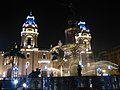 Cathedral of Limafacing the Plaza de Armas
 -
 A detailed map of the district, showing important avenues.


See also
Notes
- ^ As the administrative district of the Peruvian Republic
References
External links
- (in Spanish) Municipalidad Metropolitana de Lima Archived 1999-04-20 at the Wayback Machine - Metropolitan Lima Municipal Council official website
 Geographic data related to Lima District at OpenStreetMap