
Château de Saint-Germain-en-Laye
| Château de Saint-Germain-en-Laye | |
|---|---|
 | |
 | |
| General information | |
| Location | Saint-Germain-en-Laye, France |
| Construction started | 1124 |
| Design and construction | |
| Architect(s) | Pierre Chambiges |
The Château de Saint-Germain-en-Laye (French pronunciation:
History
12th–13th centuries

The first castle, named the Grand Châtelet, was built on the site by Louis VI in 1124. The castle was expanded by Louis IX in the 1230s.
Louis IX's chapelle Saint Louis at the castle belongs to the
The castle was burned by the
16th–18th centuries
The oldest parts of the current château were reconstructed by Francis I in 1539, and have subsequently been expanded several times. On 10 July 1547 a political rivalry came to a head in a legal duel here. Against the odds, Guy I de Chabot, 7th baron de Jarnac triumphed over François de Vivonne, seigneur de la Chasteigneraie, who died the next day after what was called "coup de Jarnac".[1]

The gardens laid out at Saint-Germain-en-Laye were among a half-dozen gardens introducing the Italian garden style to France that laid the groundwork for the French formal garden. Unlike the parterres that were laid out in casual relation to existing châteaux, often on difficult sites originally selected for defensive reasons,[5] these new gardens extended the central axis of a symmetrical building façade in rigorously symmetrical axial designs of patterned parterres, gravel walks, fountains and basins, and formally planted

The gardens were remade by André Le Nôtre from 1669 to 1673, and include a 2.4 kilometre long stone terrace which provides a view over the valley of the Seine and, in the distance, Paris.
Louis XIV turned the château over to King
19th–21st centuries
In the 19th century,
On September 10, 1919 the Treaty of Saint-Germain-en-Laye, ending hostilities between the Allies of World War I and Austria, was signed at the château.[11]
During the German occupation (1940–44), the château served as the headquarters of the German Army in France.
The museum was renamed the
Gallery
-
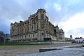
 The palace as seen from the gardens
 -
 Angle view of the palace
 -
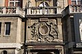
 Details of the palace's façade
 -
 The entrance of the palace
 -
 The entrance of the museum
 -
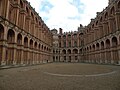 The inner courtyard
 -
 One of the staircases
 -
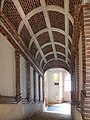
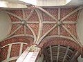 The inner ceilings


Notes
- ^ Baumgartner, Frederic (1988). Henry II: King of France 1547-1559. Duke University Press. p. 60.
- ^ Karling 1974, p 10
- ^ F. Hamilton Hazlehurst, Jacques Boyceau, pp. 20, 77–79, 100, noted by Karling.
- ^ Karling 1974, p. 11
- ^ Even the parterres at Fontainebleau bear no direct relation to the façades of the château.
- Verneuiland Saint-Germain-en-Laye.
- ^ The book was not published until 1652, but it had long been in preparation (Karling 1974).
- ^ Francini's engraving is illustrated by Karling, fig. 8.
- ^ ISBN 978-0-521-58462-3.
- ISBN 978-2-9520091-8-8. Retrieved 2013-06-12.
- ^ "Austrian treaty signed in amity," The New York Times, Sept. 11, 1919, p. 12.
- ^ Ministerial decree no. 2005-698 of June 22, 2005
External links
- Château de Saint-Germain-en-Laye at Structurae (French version of page also includes the history of the Château)
- The Château de Saint-Germain-en-Laye, National Museum of Archaeology - The official website of France (in English)
- "St-Germain-en-Laye: un haut lieu de la royauté (in French)
- Discover the Castle of Saint-Germain-en-Laye on Eurochannel
