
Chachani
| Chachani | |
|---|---|
Huascaran | |
| Coordinates | 16°11′S 71°31′W / 16.183°S 71.517°W[1] |
| Geography | |
 Chachani | |
| Geology | |
| Mountain type | Volcanic complex |
| Last eruption | Unknown |
Chachani is a
During the Pliocene and early Pleistocene, the volcanic group produced large ignimbrites such as the La Joya, Arequipa Airport and Yura Tuff ignimbrites; afterwards the volcanic group proper grew in the caldera until about 56,500 years ago. There have not been any eruptions during historical time, but the volcano is considered to be only dormant and due to its closeness to the city of Arequipa is considered high risk.
Name
The name means "brave" in Aymara[3] or "mountain of man"/"mountain of male";[4] alternative spellings "Cacheni" and "Charchani" are also known.[5]
Geography and geomorphology
The volcano lies in the
Volcanoes in the southern part of Peru include from north to south
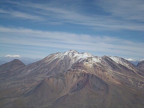
Chachani is an about 2 kilometres (1.2 mi)[a][b] high and 17 kilometres (11 mi) wide[12] complex[c] of lava domes, stratovolcanoes[6] and volcanic cones;[1] the highest summit is 6,057 metres (19,872 ft) high, making Chachani the 84th highest peak in the Andes.[21] The Chachani complex has an arcuate shape[22] encompassing both the main Chachani volcano and the[23] 5,784 metres (18,976 ft) high[7] Nocarane[24][d] to the north of Chachani,[7] while the 5,484 metres (17,992 ft) high[3] La Horqueta together with El Rodado to its west and Chachani proper to its east forms an east–west trending ridge.[20] La Horqueta has a young appearance and resembles an ash cone[22] with a crater.[26] Additional peaks are the northerly 5,852 metres (19,199 ft) high los Ángeles and the southeasterly 5,820 metres (19,090 ft) high Trigo.[3] In total, Chachani is made up of more than 12 edifices.[27]

The Colorado
The volcanic complex is formed mainly by
Chachani drains into the
Glaciation
The volcano underwent five stages of
-
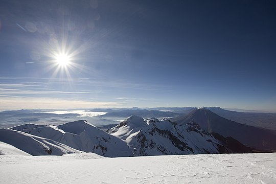 Chachani, looking eastward
 -
 Summit area
 -
 Chachani viewed from El Misti
_(5619838885).jpg)

.jpg)
Geology
Volcanic activity in the Chachani region appears to have begun during the Cretaceous-Paleocene in the form of the "Toquepala" volcanics.[37] The oldest volcanic rocks of the Western Cordillera are known under the name "Tacaza", and underwent erosion and folding before the next phase which is known as "Sillapaca".[41] Finally, during the Miocene-Quaternary the Sencca Formation and the "Barroso" volcanics developed;[37] Chachani is classified as part of the Barroso volcanics[42][20] although the oldest volcanism might belong to the "Sillapaca" unit.[26]
The terrain of the volcano is formed by volcanic rocks of Eocene to recent age, which overlie a Precambrian basement[35] and include widespread Neogene-Quaternary ignimbrites.[37] Chachani straddles the margin between the higher-elevation Altiplano and the Arequipa basin at lower altitude.[33]
The younger
Chachani has erupted
Climate and vegetation
Under the influence of the cold
From 3,500 to 3,900 metres (11,500 to 12,800 ft) elevation
Eruption history
The oldest volcanic formations linked to Chachani are the so-called "
They occur in the wider region of Chachani and crop out in the Arequipa area and in river valleys.[43] Their emplacement took place in the form of fast-moving hot streams of rock.[21] An additional ignimbrite is the 13 million years old[61] Miocene Rio Chili Ignimbrite;[43] the vents of the Miocene units are unknown[47] and the Rio Chili Ignimbrite appears to be related to the Huaylillas Ignimbrite of southern Peru.[61]
Later, during the
The youngest reported date of 56,500 ± 31,600 years ago has been obtained on the Cabrería lava domes;[20] formerly the Airport Domes/Los Angeles/Pampa de Palacio were considered to be the youngest and of Holocene age.[29] However, Volcancillo may be even younger,[64] and a post-glacial lava flow descends the western slope of Chachani between Chachani and Nocarane[23] and phreatic eruptions may have formed Holocene-age craters on Chachani.[65] No historical eruptions are known at the volcanic complex, and the date of the last activity is likewise unclear.[1]
The existence of
Hazards
.jpg)
The city of Arequipa with about one million inhabitants and infrastructure such as the
Chachani is considered to be a high-risk volcano[74] and the Geophysical Institute of Peru in 2018 installed a monitoring station on Chachani.[75] Several volcano hazard map exist: One shows three levels of danger depending on the distance from the edifice,[73] the other two show areas threatened by mudflows and pyroclastic fall.[76] Chachani is monitored with seismometers and tiltmeters.[77] Apart from eruptions, volcano-induced pollution of neighbouring water resources is a concern at Chachani.[78]
Religious importance and archeology
Chachani is the protector mountain spirit of
Mining
Chachani was reportedly mined for sulfur during the colonial era[84] and for the white "sillar" rocks that were used in construction of the[85] famous buildings of colonial-era Arequipa,[84] which is also known as the "white city".[53]
Notes
References
- ^ a b c d e f g h Palacios et al. 2009, p. 1.
- ^ a b "Chachani". Andes Specialists. Retrieved 2020-04-12.
- ^ a b c d "Volcán Chachani" (in Spanish). Ministerio de Comercio Exterior y Turismo. Archived from the original on 3 July 2020. Retrieved 26 May 2019.
- ISBN 9781139451123.
- S2CID 172863412.
- ^ a b c d Andrés et al. 2011, p. 151.
- ^ a b c d e f g h Andrés et al. 2011, p. 152.
- ^ Cuber, Panajew & Gałaś 2015, p. 64.
- ^ Legros 2001, p. 16.
- ^ ROTCH 1893, p. 284.
- ^ a b Arteaga et al. 2023, p. 49.
- ^ a b de Silva & Francis 1990, p. 288.
- ^ Bullard 1962, p. 444.
- ^ Vela et al. 2016, p. 4.
- ^ a b de Silva & Francis 1990, p. 287.
- ^ Cuber, Panajew & Gałaś 2015, p. 63.
- ^ USGS, EROS Archive. "USGS EROS Archive - Digital Elevation - SRTM Coverage Maps". Retrieved 12 April 2020.
- ^ "ASTER GDEM Project". ssl.jspacesystems.or.jp. Retrieved 14 April 2020.
- ^ TanDEM-X, TerraSAR-X. "Copernicus Space Component Data Access". Archived from the original on 12 April 2020. Retrieved 12 April 2020.
- ^ a b c d e f g Aguilar et al. 2015, p. 138.
- ^ a b c Cuber, Panajew & Gałaś 2015, p. 65.
- ^ a b c d e f g de Silva & Francis 1990, p. 293.
- ^ a b c de Silva & Francis 1990, pp. 294–295.
- ^ Bibcode:2012EGUGA..14.3677A.
- ^ Finizola et al. 2004, p. 346.
- ^ a b c d e Bullard 1962, p. 445.
- ^ a b Aguilar et al. 2022, p. 2.
- ^ a b c d Aguilar et al. 2015, p. 139.
- ^ a b c d García, Chorowicz & Legros 1997, p. 453.
- ^ a b c d "Chachani". volcano.oregonstate.edu. Archived from the original on 2019-02-20. Retrieved 2019-05-26.
- ^ a b Aguilar et al. 2015, p. 140.
- ^ García, Chorowicz & Legros 1997, p. 450.
- ^ a b Kosaka Masuno, Macedo Franco & Diaz Urquizo 2000, p. 11.
- JSTOR 519887.
- ^ a b c d Pallares et al. 2015, p. 644.
- ^ a b García, Chorowicz & Legros 1997, p. 451.
- ^ a b c d Lebti et al. 2006, p. 252.
- ^ a b c Payne, D. (1998). "Climatic implications of rock glaciers in the arid Western Cordillera of the Central Andes". Glacial Geology and Geomorphology: 6 – via ResearchGate.
- ^ a b Pallares et al. 2015, p. 643.
- S2CID 239545739 – via ResearchGate.
- ^ Bullard 1962, p. 443.
- ^ Kosaka Masuno, Macedo Franco & Diaz Urquizo 2000, p. 14.
- ^ a b c Lebti et al. 2006, p. 254.
- ^ Finizola et al. 2004, p. 348.
- ^ Legros 2001, p. 26.
- ISSN 0016-7002.
- ^ Bibcode:2003EAEJA....10465P.
- ISSN 1138-9788.
- ^ ROTCH 1893, p. 285.
- ^ Palacios et al. 2009, p. 2.
- ^ ROTCH 1893, p. 282.
- doi:10.1038/052514a0.
- ^ a b c Cuber, Panajew & Gałaś 2015, p. 66.
- ^ Love 2017, p. 26.
- S2CID 33036188.
- ISSN 2682-955X.
- ^ García, Chorowicz & Legros 1997, p. 449.
- ^ Lebti et al. 2006, p. 253.
- ^ Lebti et al. 2006, pp. 254–255.
- ^ Lebti et al. 2006, p. 273.
- ^ a b Lebti et al. 2006, p. 257.
- ^ Pallares et al. 2015, p. 645.
- ^ Aguilar et al. 2015, pp. 138–139.
- ^ a b Arteaga et al. 2023, p. 50.
- ^ Aguilar et al. 2022, p. 15.
- ^ JSTOR 3451364.
- ^ Macedo, Orlando; Ancassi, Rosa; Centeno, Ricky (2014). "Sismos distales de fractura observados en la zona de los volcanes Misti y Chachani". Repositorio Institucional - IGP (in Spanish): 4.
- S2CID 135125919.
- ^ Rivera et al. 2021, p. 3.
- ^ a b Vela et al. 2016, p. 14.
- ^ a b Rivera et al. 2021, p. 20.
- ^ Arteaga et al. 2023, p. 53.
- ^ a b Arteaga et al. 2023, p. 51.
- ^ Vela et al. 2016, p. 29.
- ^ "Arequipa: IGP inicia vigilancia de actividad volcánica del Chachani". El Comercio. 2 September 2018. Retrieved 26 May 2019.
- ^ Arteaga et al. 2023, p. 52.
- S2CID 240447272.
- S2CID 251690349.
- ^ Love 2017, p. 25.
- ^ Ceruti 2013, p. 370.
- ^ Ceruti 2013, pp. 360–361.
- ^ Ceruti 2013, p. 362.
- S2CID 230526835.
- ^ a b Ceruti 2013, p. 369.
- ^ Ceruti 2013, p. 361.
Sources
- Aguilar, R.; Thouret, J.-C.; Suaña, E.; Samaniego, P.; Jicha, B.; Rivera, M. (14–16 October 2015). Evolution of along-lived volcanic complex: The Chachani case study (South Peru). Foro Internacional sobre la Gestion del Riesgo Geológico, Arequipa. pp. 138–141.
- Aguilar, Rigoberto; Thouret, Jean-Claude; Samaniego, Pablo; Wörner, Gerhard; Jicha, Brian; Paquette, Jean-Louis; Suaña, Edwin; Finizola, Anthony (June 2022). "Growth and evolution of long-lived, large volcanic clusters in the Central Andes: The Chachani Volcano Cluster, southern Peru" (PDF). Journal of Volcanology and Geothermal Research. 426: 107539. S2CID 247896674.
- Andrés, Nuria; Palacios, David; Úbeda, Jose; Alcalá, Jesús (1 September 2011). "Ground thermal conditions at chachani volcano, southern peru". Geografiska Annaler: Series A, Physical Geography. 93 (3): 151–162. S2CID 128858886.
- Arteaga, D.; Manrique, N.; Aguilar, R.; Soncco, Y.; Van Wyk de Vries, B.; Palacios, C.; Tito, V.; Pacsi, E.; Delgado, R.; Sanz, S. (2023). "Mapa de peligros del complejo volcánico Chachani, Arequipa–Perú". In Masías, P.; Ortega, M. (eds.). Libro de Resúmenes IX Foro Internacional de Peligros Volcánicos – IX FIPVO (in Spanish). Lima: Instituto Geológico Minero y Metalúrgico. pp. 49–54.
- Bullard, Fred M. (1 December 1962). "Volcanoes of Southern Peru". Bulletin Volcanologique. 24 (1): 443–453. S2CID 140637499.
- Ceruti, María Constanza (2013). "Chachani, Misti y Pichu Picchu: pasado y presente de los volcanes sagrados de Arequipa". Anuario de Arqueología, Rosario (2013), 5. ISSN 1852-8554.
- Cuber, Piotr; Panajew, Paweł; Gałaś, Andrzej (30 November 2015). "Stratovolcanoes in the Western Cordillera – Polish Scientific Expedition to Peru 2003–2012 reconnaissance research". Geotourism/Geoturystyka. 37 (2): 61. ISSN 2353-3641.
- de Silva, SL; Francis, PW (1 March 1990). "Potentially active volcanoes of Peru-Observations using Landsat Thematic Mapper and Space Shuttle imagery". Bulletin of Volcanology. 52 (4): 286–301. S2CID 140559785.
- Finizola, Anthony; Lénat, Jean-François; Macedo, Orlando; Ramos, Domingo; Thouret, Jean-Claude; Sortino, Francesco (August 2004). "Fluid circulation and structural discontinuities inside Misti volcano (Peru) inferred from self-potential measurements" (PDF). Journal of Volcanology and Geothermal Research. 135 (4): 343–360. S2CID 129363841.
- García, FF; Chorowicz, J; Legros, F (1997). La caldera Chachani, gran centro explosivo Plioceno–Holoceno del sur del Perú? Identificacíon y evolucíon en imagenes Landsat y Radar ERS. IX Congreso Peruano de Geologia (in Spanish). Vol. Especial. Sociedad Geológica del Perú – via ResearchGate.
- Kosaka Masuno, Roberto; Macedo Franco, Luisa; Diaz Urquizo, Hector G (2000). "Mapa de peligro potencial del volcán Misti" (PDF). Centro de Información del INDECI (in Spanish). Universidad Nacional de San Agustín.
- Lebti, Perrine Paquereau; Thouret, Jean-Claude; Wörner, Gerhard; Fornari, Michel (June 2006). "Neogene and Quaternary ignimbrites in the area of Arequipa, Southern Peru: Stratigraphical and petrological correlations". Journal of Volcanology and Geothermal Research. 154 (3–4): 251–275. .
- Legros, F (April 2001). "Tephra stratigraphy of Misti volcano, Peru". Journal of South American Earth Sciences. 14 (1): 15–29. .
- Love, Thomas F. (2017). The Independent Republic of Arequipa: Making Regional Culture in the Andes. University of Texas Press. ISBN 9781477314593.
- Palacios, D.; Andrés, N.; Úbeda, J.; Alcalá, J. (2009). Permafrost and Periglacial Activity Distribution and Geothermal Anomalies in the Chachani and El Misti Volcanoes (Southern Peru). 2009EGU General Assembly. Geophysical Research Abstracts. Vol. 11.
- Pallares, Carlos; Fabre, Denis; Thouret, Jean-Claude; Bacconnet, Claude; Charca-Chura, Juan Antonio; Martelli, Kim; Talon, Aurélie; Yanqui-Murillo, Calixtro (1 June 2015). "Geological and geotechnical characteristics of recent lahar deposits from El Misti volcano in the city area of Arequipa, South Peru". Geotechnical and Geological Engineering. 33 (3): 641–660. S2CID 140190353.
- Rivera, Marco; Del Carpio Calienes, José Alberto; Tavera, Hernando; Cruz Igme, John Edward; Vargas Alva, Katherine Andrea; Torres Aguilar, José Luis; Concha Calle, Jorge Andrés (February 2021). Análisis y evaluación de escenarios críticos por descenso de lahares en volcanes peruanos (Report).
- ROTCH, A. LAWRENCE. (1893). "THE HIGHEST METEOROLOGICAL STATION IN THE WORLD". American Meteorological Journal. A Monthly Review of Meteorology and Allied Branches of Study (1884-1896). 10 (6).
- Vela, Jesica; Cáceres, Jesús; Calderón, Javier; Chijcheapaza, Rolando; Apaza, Freddy; Vilca, Javier; Masias, Pablo; Álvarez, Yovana; Miranda, Rafael (May 2016). "Evaluación del riesgo volcánico en el sur del Perú, situación de la vigilancia actual y requerimientos de monitoreo en el futuro". Repositorio Institucional - IGP (in Spanish).
Bibliography
- "Nevado Chachani". Global Volcanism Program. Smithsonian Institution.
- Chachani on SummitPost
- "Nevado Chachani, Peru" on Peakbagger
- Chachani on Peakware