
Chanditala I
Chanditala I | |
|---|---|
Community development block | |
Jangipara | |
| Website | hooghly |
Chanditala I is a
Overview
The Chanditala I CD Block is part of the Hooghly-Damodar Plain, one of the three natural regions in the district of the flat alluvial plains, that forms part of the Gangetic Delta. The region has many depressions which receive water from the surrounding lands during the rainy season and discharge the water through small channels.[1]
Geography

Bhagabatipur, a constituent gram panchayat of Chanditala I block, is located at 22°42′00″N 88°10′50″E / 22.6999504°N 88.1804752°E.
Chanditala I CD Block is bounded by Haripal and Singur CD Blocks in the north, Chanditala II CD Block in the east, Domjur and Jagatballavpur CD Blocks, in Howrah district, in the south and Jangipara CD Block in the west.[2]
It is located 34 km from
Chanditala I CD Block has an area of 93.45 km2. It has 1

Gram panchayats of Chanditala I block/ panchayat samiti are: Aniya, Bhagabatipur, Gangadharpur, Haripur, Krishnarampur, Kumirmora, Masat, Nababpur and Sehakhala.[6]
Demographics
Population
As per the
As of 2001[update] census, Chanditala I block had a total population of 165,837, out of which 81,689 were males and 84,148 were females. Chanditala I block registered a population growth of 11.38% during the 1991-2001 decade. Decadal growth for Hooghly district was 15.72%.[8] Decadal growth in West Bengal was 17.84%.[9]
Large villages (4,000+ population) in Chanditala I CD Block (2011 census figures in brackets): Patul (4,083), Sehakhala (6,434), Kanaidanga (4,517), Bhadua (4,704) and Krishnarampur (10,044).[7]
Other villages in Chanditala I CD Block (2011 census figures in brackets):
Literacy
As per the 2011 census the total number of literates in Chanditala I CD Block was 134,421 (83.76% of the population over 6 years) out of which males numbered 70,740 (88.24% of the male population over 6 years) and females numbered 63,681 (79.65% of the female population over 6 years). The gender disparity (the difference between female and male literacy rates) was 8.59%.[7]
As of 2001[update] census, Chanditala I block had a total literacy of 52.75%. While male literacy was 73.52%, female literacy was 55.09%.[11]
See also – List of West Bengal districts ranked by literacy rate
| Literacy in CD Blocks of Hooghly district |
|---|
| Arambagh subdivision |
| Arambagh – 79.10 |
| Khanakul I – 77.73 |
| Khanakul II – 79.16 |
| Goghat I – 78.70 |
| Goghat II – 77.24 |
| Pursurah – 82.12 |
| Chandannagar subdivision |
| Haripal – 78.59 |
| Singur – 84.01 |
| Tarakeswar – 79.96 |
| Chinsurah subdivision |
| Balagarh – 76.94 |
| Chinsurah Mogra – 83.01 |
| Dhaniakhali – 75.66 |
| Pandua – 75.86 |
| Polba Dadpur – 75.14 |
| Srirampore subdivision |
| Chanditala I – 83.76 |
| Chanditala II – 84.78 |
| Jangipara – 75.34 |
Sreerampur Uttarpara – 87.33
|
| Source: 2011 Census: CD Block Wise Primary Census Abstract Data |
Language and religion
As per the 2011 census, majority of the population of the district belong to the Hindu community with a population share of 82.9% followed by Muslims at 15.8%. The percentage of the Hindu population of the district has followed a decreasing trend from 87.1% in 1961 to 82.9% in the latest census 2011. On the other hand, the percentage of Muslim population has increased from 12.7% in 1961 to 15.8% in 2011 census.[13]
In the 2011 census Hindus numbered 117,300 and formed 65.23% of the population in Chanditala I CD Block. Muslims numbered 62,225 and formed 34.60% of the population. Others numbered 300 and formed 0.17% of the population.[12]
Bengali is the predominant language, spoken by 99.49% of the population.[14]
Rural poverty
As per poverty estimates obtained from household survey for families living
Economy
Livelihood
Livelihood
in Chanditala I CD Block
In Chanditala I CD Block in 2011, amongst the class of total workers, cultivators formed 9.24%, agricultural labourers 18.10%, household industry workers 10.41% and other workers 62.25%.[16]
Infrastructure
There are 47 inhabited villages in Chanditala I CD Block. 100% villages have power supply. 14 villages have more than one source of drinking water (tap, well, tube well, hand pump), 27 villages have only tube well/ borewell and 6 villages have only hand pump. 3 villages have sub post offices and 2 villages have post and telegraph offices. 47 villages have landlines, 37 villages have public call offices and 47 villages have mobile phone coverage. 28 villages have pucca roads and 28 villages have bus service (public/ private). 2 villages have agricultural credit societies and 6 villages have commercial/ co-operative banks.[17]
| Important Handicrafts of Hooghly District |
|---|
Source:District Human Development Report 2010: Hooghly P. 67 |
Agriculture
Although a large proportion of the people is engaged in non-agricultural pursuits, this is a rich agricultural area with several cold storages.[18] Along with rice, the prime crop of the district, the agricultural economy largely depends on potato, jute, vegetables, and orchard products. Vegetable is a prize crop in the blocks of Haripal, Singur, Chanditala, Polba and Dhaniakhali being grown in a relay system throughout the year. Potato is cultivated in all the blocks of this district.[19][16]
Some of the primary and other hats or markets in the Chanditala I CD Block area are: Jangalpara hat, Mesat hat, Sheakhala hat, Bhagakalipur hat, Gopalpur hat and Gangadharpur hat.[20]
In 2013-14, the comparatively small percentage of persons engaged in agriculture in Chanditala I CD Block could be classified as follows:
Chanditala I CD Block had 53 fertiliser depots, 15 seed stores and 59
In 2013-14, Chanditala I CD Block produced 341 tonnes of Aman paddy, the main winter crop from 167 hectares, 10,259 tonnes of Boro paddy (spring crop) from 3,097 hectares, 4,282 tonnes of jute from 202 hectares, 51,925 tonnes of potatoes from 1,854 hectares. It also produced pulses and oilseeds .[16]
In 2013-14, the total area irrigated in Chanditala I CD Block was 6,985 hectares, out of which 2,560 hectares were irrigated by canal water, 1,500 hectares by tank water, 620 hectares by deep tube wells and 2,305 hectares by shallow tube wells.[16]
Banking
In 2013-14, Chanditala I CD Block had offices of 12 commercial banks and 1
Transport
Chanditala I CD Block has 9 originating/ terminating bus routes.[16]
Education
In 2013-14, Chanditala I CD Block had 94 primary schools with 9,796 students, 7 middle schools with 980 students, 6 high schools with 6,353 students and 12 higher secondary schools with 18,364 students. Chanditala I CD Block had 1 general college with 1,301 students, 254 institutions for special and non-formal education with 7,114 students[16]
Vidyasagar Mahavidyalaya, a general degree college, was established at Suchia, Masat in 1998.[21]
In Chanditala I CD Block, amongst the 47 inhabited villages, 2 villages had no school, 23 villages had more than 1 primary school, 31 villages had at least 1 primary school, 14 villages had at least 1 primary and 1 middle school and 10 villages had at least 1 middle and 1 secondary school.[17]
Healthcare
In 2014, Chanditala I CD Block had 1 block primary health centre, 3 primary health centres and 6 private nursing homes with total 130 beds and 6 doctors (excluding private bodies). It had 32 family welfare subcentres. 2,696 patients were treated indoor and 233,480 patients were treated outdoor in the hospitals, health centres and subcentres of the CD Block.[16]
Chanditala I CD Block has Akuni Ichhapasar Rural Hospital (with 30 beds) at PO Aniya, Bhattapur Primary Health Centre at PO Akuni (with 4 beds), Gangadharpur PHC (with 10 beds) and Jangalpara PHC (with 6 beds).[22]
Chanditala I CD Block is one of the areas of Hooghly district where ground water is affected by low level of arsenic contamination. The WHO guideline for arsenic in drinking water is 10 mg/ litre, and the Indian Standard value is 50 mg/ litre. In Hooghly district, 16 blocks have arsenic levels above WHO guidelines and 11 blocks above Indian standard value. The maximum concentration in Chanditala I CD Block is 33 mg/litre.[23]
Chanditala-I All GP Map picture gallery
-
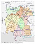 MAP OF CHANDITALA-I CD BLOCK
 -
 Map of Chanditala-i CD Block
 -
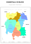
 Map of Chanditala-I CD block sowing 56 Mouzas
 -
 Map of Aniya GP
 -
 Map of BHAGABATIPUR GP
 -
 Map of Gangadharpur GP
 -
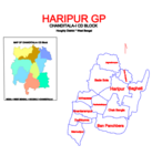 Map of Haripur GP
 -
 Map of KRISHNARAMPUR GP
 -
 Map of KUMIRMARA GP
 -
 Map of Masat GP
 -
 MAP OF NABABPUR GP
 -
 Map of Sehakhala GP


References
- ^ "District Census Handbook: Hugli, Series-20, Part XIIA" (PDF). Physigraphy, Page 17. Directorate of Census Operations, West Bengal, 2011. Retrieved 1 June 2017.
- ^ "Map of Hooghly district". District Profile. Hooghly district administration. Retrieved 20 May 2016.
- ^ "District Statistical Handbook 2014 Hooghly". Tables 2.1, 2.2. Department of Statistics and Programme Implementation, Government of West Bengal. Archived from the original on 21 January 2019. Retrieved 15 October 2018.
- ^ "District Census Handbook: Hugli, Series-20, Part XIIA" (PDF). Map of Hooghly district with CD Block HQs and Police Stations (on the fifth page). Directorate of Census Operations, West Bengal, 2011. Retrieved 1 June 2017.
- ^ "Chanditala I". Local Self-government. Hooghly Zilla Parishad. Retrieved 6 June 2017.
- ^ "Directory of District, Subdivision, Panchayat Samiti/ Block and Gram Panchayats in West Bengal". Hooghly – Revised in March 2008. Panchayats and Rural Development Department, Government of West Bengal. Retrieved 16 May 2016.
- ^ a b c d e "C.D. Block Wise Primary Census Abstract Data(PCA)". 2011 census: West Bengal – District-wise CD Blocks. Registrar General and Census Commissioner, India. Retrieved 26 May 2016.
- ^ "Provisional Population Totals, West Bengal. Table 4". Census of India 2001 – Hooghly district. Census Commission of India. Archived from the original on September 28, 2011. Retrieved 2011-01-20.
- ^ "Provisional Population Totals, West Bengal. Table 4". Census of India 2001. Census Commission of India. Archived from the original on September 27, 2007. Retrieved 2011-01-20.
- ^ "Mouza Information". Land & Land Reforms Department, Government of West Bengal. Archived from the original on 2016-12-22. Retrieved 2016-04-09.
- ^ "Chanditala I". Local Self-government. Hooghly Zilla Parishad. Retrieved 2011-08-04.
- ^ a b "Table C-01 Population by Religion: West Bengal". censusindia.gov.in. Registrar General and Census Commissioner of India. 2011.
- ^ "District Census Handbook: Hugli, Series-20, Part XIIA" (PDF). Religion, Mother-tongue Pages 50-51. Directorate of Census Operations, West Bengal, 2011. Retrieved 1 June 2017.
- ^ "Table C-16 Population by Mother Tongue: West Bengal". www.censusindia.gov.in. Registrar General and Census Commissioner of India.
- ^ "District Human Development Report: Hooghly" (PDF). Table 2.38: Empirical Measurement of Rural Poverty in Hogghly 2005, page 89. Development and Planning Department, Government of West Bengal, 2011. Archived from the original (PDF) on 2017-08-07. Retrieved 14 June 2017.
- ^ a b c d e f g h i j "District Statistical Handbook 2014 Hooghly". Tables 2.7, 17.2, 16.1, 18.1, 18.2, 20.1, 21.2, 4.4, 3.1, 3.3 – arranged as per use. Department of Statistics and Programme Implementation, Government of West Bengal. Archived from the original on 21 January 2019. Retrieved 15 October 2018.
- ^ a b "District Census Handbook: Hugli, Series-20, Part XIIA" (PDF). Appendices to Village Directory, 2009, Pages 775-779. Directorate of Census Operations, West Bengal, 2011. Retrieved 1 June 2017.
- ^ "List of functioning Cold Storage of West Bengal District wise as on 18.01.07". West Bengal State Marketing Board. Archived from the original on 22 January 2009. Retrieved 28 January 2009.
- ^ "Intensive cropping with remarkable feature of Hooghly District". Archived from the original on 2011-07-16. Retrieved 28 January 2009.
- ^ "Primary Hats/Markets of District". Hooghly. West Bengal State Marketing Board. Archived from the original on 2009-07-07. Retrieved 6 June 2016.
- ^ "Vidyasagar Mahavidyalaya". VM. Retrieved 30 June 2017.
- ^ "Health & Family Welfare Department". Health Statistics. Government of West Bengal. Archived from the original on 28 October 2021. Retrieved 15 July 2017.
- ^ "Groundwater Arsenic contamination in West Bengal-India (20 years study )". Hugli. SOES. Archived from the original on 2017-05-24. Retrieved 3 June 2017.