
Chandragiri Fort, Kerala
Chandragiri Fort
ചന്ദ്രഗിരി കോട്ട | |
|---|---|
UTC+5:30 (IST ) |

Chandragiri Fort (
Geography
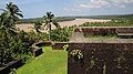
Chandragiri Fort was built in the confluence of the Arabian Sea and the Chandragiri River, also known as the Payaswini river.[2] The fort is located about 59 kilometers south of Mangalore and 87 kilometers north of Kannur.
History
The Chandragiri River marked the boundary between the Tulanadu and the Kolathanadu Kingdoms.[2] Both kingdoms would eventually be conquered by the Vijaynagara Empire, and the region came under their control.[2][3] Upon the fall of the Vijaynagara Empire, the Keladi Nayakas, who had administered the region for the Vijaynagara Empire, declared independence and took control of many regions of Uttara Kannada, including the area the fort would later be built.[2][3]
Chandragiri Fort was built in the 17th century by
Layout
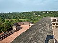
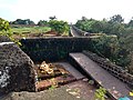
The found boundary area is approximately 7.76 acres, while the building is roughly 5 acres and of a square shape.[4][5] The fort is 46 meteres (150) feet above sea level, and composed of laterite bricks. Some of the walls were damaged from cannon fire.[2] A trench surrounds the fort from three directions. On the Eastern and Western direction, both have entrances leading into the trench. On the North-Eastern corner, an underground tunnel is also visible.[4]
The fort contains 8 bastions, each with cannon (peeranky) holes. The main bastion is located on the North. Other buildings, such as barracks, are also within the fort.[4]
Image gallery
-
 Chandrigiri Fort Melparamba, is 6 Kilometers away from Kasaragod town
 -
 Chandragiri Fort renovation works 2019
 -
 Chandragiri Fort entrance
 -
 Chandragiri Fort renovation works 2019
 -
 Chandragiri Fort renovation works 2019
 -
 Chandragiri Fort renovation works 2019
 -
 Chandragiri Fort renovation works 2019
 -
 Chandragiri Fort renovation works 2019
 -
 Chandragiri Fort
 -
 Chandragiri Fort
 -
 Chandragiri Fort
 -
 Chandragiri Fort
 -
 Chandragiri Fort renovation works 2019
 -
 Chandragiri Fort


References
- ^ Divakaran, Kattakada (2005). Kerala Sanchaaram. Trivandrum, India: Z Library. p. 925.
- ^ a b c d e "Chandragiri Fort - a ruined fort above 46 m sea level, Kasaragod | Forts in Malabar districts, Kerala". www.keralatourism.org. Retrieved 3 August 2023.
- ^ a b c "Chandragiri Fort Kasaragod". ReachKerala. Retrieved 3 August 2023.
- ^ a b c d "Chandragiri Fort | Forts protected by Department of Archaeology | Protected Monuments". Archaeology. Retrieved 3 August 2023.
- ^ "DRAFT REPORT ON COASTAL ZONE MANAGEMENT PLAN (CZMP) FOR KASARAGOD DISTRICT – KERALA (Prepared as per CRZ Notification 2019)" (PDF). www.coastal.keltron.org.
External links
See also
- Kannur Fort
- Thalassery Fort
- Bekal Fort
- Hosdurgfort