
Chandrapur
Chandrapur
Chanda | ||
|---|---|---|
City | ||
Municipal Commissioner Vipin Paliwal, IAS | | |
| • Chairman, Standing Committee | Ramu Tiwary | |
| Area | ||
| • Total | 76 km2 (29 sq mi) | |
| • Rank | East Vidarbha: 2nd District: 1st | |
| Elevation | 188 m (617 ft) | |
| Population (2011) | ||
| • Total | 355,739 Chandrapur Urban Area | |
| • Rank | Vidarbha: 4th | |
UTC+5:30 (IST) | ||
| PIN | 442401,442402,442403,442404 | |
| Telephone code | (+91), 7172 | |
| Vehicle registration | MH-34 | |
| Website | Official website | |
Chandrapur (earlier known as Chanda, the official name until 1964) is a
Etymology
The local people relate the name "Chandrapur" to the words Chandra (the moon) and pur (a settlement) after a legend. Scholars see the name as a derivative of "Indupur" (city of the moon) which stood near the Jharpat in the Treta Yuga.
History
There are many Stone Age sites in Chandrapur District. Suresh Chopane, a renowned researcher, found many stone-age tools in the district, which has been displayed in his Rock Museum. Archeological finds, such as signs of pottery making, suggest inhabitation of the Chandrapur area in Neolithic times.[3]
From ancient times, Chandrapur has fallen under the control of many different rulers. Between 322 BCE and 187 BCE, much of India, including Maharashtra, was part of the
The Gond people are part of the Adivasi (indigenous people) of India. In ancient times, the Gond diaspora spread throughout central India. After the passage of many kings, who were largely subservient to other rulers, the Gond king, Khandkya Ballal (1470 – 1495) came to the throne. He founded Chandrapur.[11]
As per legends, Khandkya, who resided in Sirpur, was covered in tumours. His wise and beautiful wife nursed him. She asked him to leave Sirpur and move to the north bank of the Wardha River. There, the king built a fort he named "Ballalpur" and thus founded the city of Ballarpur. In the year of 1262, one day while hunting northwest of Ballalpur, the king became thirsty and rode up to the dry bed of the Jharpat river in search of water. He discovered water trickling from a hole, and after drinking, washed his face, hands and feet. That night, he slept soundly for the first time in his life.
On his return, the queen was delighted to see that many of the tumours on her husband's body had disappeared. The king said it was the water that had cured him and took his wife to see the water hole. On clearing the grass and sand, they found five footprints of a cow in the solid rock, each filled with water. The water source at the spot was inexhaustible and considered holy. The place was called "Tirtha of Acalesvar of the Treta Yuga". When the king bathed in the water, all the tumours on his body vanished. That night at the water hole, Acalesvar appeared to the king in a dream and spoke comforting words. A temple was built over the water hole.
One morning, at the water hole, the king saw a hare darting out of a bush and chasing his dog. Eventually, the dog killed the hare. The king found a white spot on the forehead of the hare. The queen said it was a good omen and a fortified city should be built with its layout based on the chase of the dog and hare. She said the place where the hare was killed would be unlucky for the city. The king's officers, the "Tel Thakurs" built the fortified city. The city became Chandrapur.
Chandrapur was taken over by Nagpur Bhonsles in 1751 during the
In 1956, with the reorganization of Indian states, Chandrapur district was transferred from
Geography
Chandrapur is located in central India in the eastern part of Maharashtra state at 19.57°N latitude and 79.18°E longitude. Chandrapur is situated at 189.90 meters above the mean sea level. The area of the city is about 162.41 km2. The north–south length of the city is about 15.90 km, while the east–west length is about 10.90 km. The city slopes from the north to the south.
Chandrapur lies at the confluence of the Erai and Zarpat rivers. The Erai river has a history of flooding. Flood marks are seen on the walls of the city. In the north of the city, a dam is constructed on the river Erai, having the capacity of 207 million cubic meters. The Gaontideo Nala originates from the uplands of the Chandrapur Super Thermal Power Station. The Macchhi Nala originates from uplands of Central Forest Rangers College.
Chandrapur lies on terrain rich in coal. Chandrapur is called a "geological museum" as there is a large variety of rocks as well as commercially valuable minerals and fossils. Samples of such rocks are collected at the Suresh Chopane Rock Museum.[13]
Climate
Chandrapur has a hot and dry climate. December is the coldest month, with a minimum average temperature of 9 °C and a maximum average temperature of 23.2 °C. May is the hottest month with a mean maximum temperature of 43 °C and a mean minimum temperature of 28.2 °C. On 2 June 2007, there was the highest recorded temperature of 49 °C.[In January 1899 & 2021] , there was the lowest recorded temperature of 2.8 °C.
The monsoon season comes between June and September. Chandrapur's average annual rainfall is 1249.4 mm. The average number of rainy days is 59.2.[14]
| Climate data for Chandrapur (1981–2010, extremes 1901–2012) | |||||||||||||
|---|---|---|---|---|---|---|---|---|---|---|---|---|---|
| Month | Jan | Feb | Mar | Apr | May | Jun | Jul | Aug | Sep | Oct | Nov | Dec | Year |
| Record high °C (°F) | 35.8 (96.4) |
40.0 (104.0) |
44.4 (111.9) |
46.4 (115.5) |
48.3 (118.9) |
49.0 (120.2) |
40.6 (105.1) |
37.2 (99.0) |
38.4 (101.1) |
40.1 (104.2) |
36.1 (97.0) |
38.7 (101.7) |
49.0 (120.2) |
| Mean daily maximum °C (°F) | 30.5 (86.9) |
33.4 (92.1) |
37.6 (99.7) |
41.3 (106.3) |
42.9 (109.2) |
38.0 (100.4) |
32.0 (89.6) |
30.8 (87.4) |
32.4 (90.3) |
32.7 (90.9) |
31.1 (88.0) |
29.9 (85.8) |
34.4 (93.9) |
| Mean daily minimum °C (°F) | 14.8 (58.6) |
16.9 (62.4) |
21.1 (70.0) |
25.2 (77.4) |
28.0 (82.4) |
26.6 (79.9) |
24.4 (75.9) |
24.0 (75.2) |
24.0 (75.2) |
21.5 (70.7) |
16.8 (62.2) |
13.4 (56.1) |
21.4 (70.5) |
| Record low °C (°F) | 2.8 (37.0) |
3.9 (39.0) |
7.2 (45.0) |
11.7 (53.1) |
18.9 (66.0) |
20.0 (68.0) |
17.8 (64.0) |
18.3 (64.9) |
18.3 (64.9) |
10.9 (51.6) |
6.2 (43.2) |
3.5 (38.3) |
2.8 (37.0) |
| Average rainfall mm (inches) | 9.2 (0.36) |
12.8 (0.50) |
15.4 (0.61) |
17.1 (0.67) |
21.2 (0.83) |
202.8 (7.98) |
358.1 (14.10) |
363.7 (14.32) |
158.3 (6.23) |
73.1 (2.88) |
10.2 (0.40) |
6.2 (0.24) |
1,248.2 (49.14) |
| Average rainy days | 0.8 | 0.8 | 1.4 | 1.5 | 1.8 | 8.7 | 15.2 | 14.6 | 8.5 | 3.6 | 0.7 | 0.5 | 58.1 |
| Average relative humidity (%) (at 17:30 IST )
|
44 | 34 | 27 | 22 | 23 | 48 | 70 | 75 | 68 | 60 | 53 | 48 | 48 |
| Source: India Meteorological Department[15][16] | |||||||||||||
Demographics
Per the 2011 census of India, Chandrapur's population was 375,000.
Languages
Akhil Bharatiya Marathi Sahitya Sammelan, the conference on Marathi literature, has been held twice in Chandrapur, in 1979 (Chair Vaman Krushna Chorghade) and in 2012 (Chair Vasant Aabaji Dahake).[17]
In 2016, the inaugural All India Gondi Religious Convention was convened by the Central Provinces and Berar Gondwana Samaj Sewa Samiti in Warora, 30 km north west of Chandrapur. The Chair was Raja Virshah Krushnashah Atram, a descendant of Khandkya Ballal Sah and current titular Gond king of Chandrapur.
Religion
According to the 2011 India census, total population was 3,20,379.[18]
| Year | Male | Female | Total Population | Change |
|---|---|---|---|---|
| 2001[19] | 151202 | 138248 | 289450 | - |
| 2011[18] | 164085 | 156294 | 320379 | 0.107 |
Transport
Chandrapur lies on major state highways MH MSH 6, MH MSH 9 and state highways MH SH 233, MH SH 243 and MH SH 264. Chandrapur is connected to many cities in Maharashtra by the Maharashtra State Road Transport Corporation bus service. Bus services are offered to Pune, Nagpur, Amravati, Yavatmal, Hyderabad, and Raipur. A proposed Chandrapur Pune expressway, via Yavatmal Beed, is in the planning stages.
Chandrapur Airport, operated by the Maharashtra Airport Development Company, is situated near Morwa on MH SH 264, about 12 km from the city. The airstrip is 950 m in length. Development of the airport is limited by surrounding obstructions, particularly the thermal power plant.[21] Hence, the MADC is building a greenfield airport at Vihirgaon, 40 kilometres from Chandrapur.[22] The nearest airport with scheduled flights is the Dr. Babasaheb Ambedkar International Airport in Nagpur.
Economy
Chandrapur is a centre for coal mining. In 2012, there were 27 coal mines around Chandrapur.[23]
Other industries include cement making, paper manufacturing, and ferro alloy manufacturing.
Chandrapur Super Thermal Power Station
The
Education
The Karmavir Dadasaheb Kannamwar High School (previously known as the Zilha Parishad Jubilee High School) was established in 1906. The Lokmanya Tilak Vidyalaya was founded by Bal Gangadhar Tilak. The Chanda Sikshan Prasarak Mandal is a large educational institution with a number of campuses in Chandrapur.
Professional
Chandrapur has a government medical college and a government engineering college. The city's colleges (apart from the medical college) are affiliated with Gondwana University.
Administration
On 20 October 2011, Chandrapur municipal council was elevated to a D-grade municipal corporation.[24]
Important places
The Chandrapur Fort (earlier known as Chanda Fort) (today called "old city") is a
-
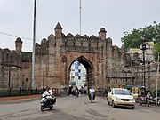 Jatpura gate of Chandrapur Fort
 -
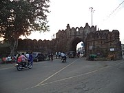 Anchaleshwar gate of Chandrapur Fort
 -
 Pathanpura gate of Chandrapur Fort


- Mahakali Mandir

Mahakali
Within the temple are two murtis (idols). One associated with Shiv Ling is a standing idol decorated with red, yellow and orange cloths. The other is in a reclining position below the ground level, and devotees must walk in a tunnel to reach it. Inside the temple, a priest is present to assist visitors with puja and offerings. A trust administers the temple. Dharmashalas provide accommodation for pilgrims. The annual yatra (fair) takes place in April, entertaining the followers of Mahakali and the citizens of Chandrapur.
- Anchaleshwar Mandir

The Anchaleshwar Mandir celebrates a form of the Lord Siva. It is situated adjoining Anchaleshwar Gate of Chandrapur fort on the banks of the Zarpat river. The official samadhi (mausoleum) of the Gond kings is located within the temple complex.
- Tadoba Andhari Tiger Reserve

The Tadoba Andhari Tiger Reserve is located approximately 30 km north of Chandrapur near the Erai dam. This park was included in the project tiger since 1973. The total area of the reserve is 625.40 km2. In 2014 the tiger population in Tadoba was 66, that number has gone up to 86. Tadoba is now a home to 86 Tigers despite years of lynching, poaching & other threats.[26] There are many hotels and resorts near Moharli gate, Zari gate and Navegaon gate of the reserve, available for the tourists. The guided tours inside the park are available during early morning and evening time only.[25][27]
Notable people
- Karmavir Dadasaheb Kannamwar, second Chief Minister of Maharashtra.
- Rashtriya Swayamsewak Sangh.
- Hansraj Ahir, former Deputy Home Minister Of India (MOS Home affairs) and also Union minister of Chemical and Fetilizers (MOS) Govt. of India.
- Shantaram Potdukhe, former Minister of State (Finance) of India.
- Barrister Rajabhau Khobragade, Deputy Chairman of Rajya Sabha, leader of the Republican Party of India (Khobragade) and follower of B. R. Ambedkar.
- Balasaheb Deshmukh, a follower of Bal Gangadhar Tilak. It was due to his efforts that Tilak visited Chandrapur and laid the foundation of Lokmanya Tilak Vidyalaya.
- MLC, 5th Loksabha.
- Sudhir Mungantiwar, former Minister of Finance & Planning and Forests Govt.of Maharastra, former Guardian Minister of Wardha and Chandrapur.[28]
- Swagat Thorat, a wildlife photographer, playwright, painter, editor, and director. Known as the Braille Man of India.
See also
- Make In Maharashtra
- Urjanagar
References
- ISBN 978-8180694745.
- ^ EARTHCARE LABS PVT. LTD (March 2017). PRE FEASIBILITY REPORT Of Stone Quarry (PDF). Nagpur: EARTHCARE LABS PVT. LTD. p. 2(iv). Retrieved 12 December 2019.
- ISBN 9971692716.
- ISBN 9788120804050.
- ISBN 9780520242258.
- ISBN 9788120804982.
- ^ Majumdar R.C. Vakataka - Gupta Age Circa 200-550 A.D. Motilal Banarsidass 1986. p. 123
- ISBN 9788171544684.
- ^ Ramesh, K. V. (1984). Chalukyas of Vatapi. Agam Kala Prakashan.
- ISBN 9788122411980.
- ^ "Kingdoms of South Asia". The History Files. Retrieved 12 December 2017.
- ISBN 9780199249220.
- ISBN 9780070667723.
- ^ "Ever Recorded Maximum Temperature, Minimum Temperature and 24 Hours Heaviest Rainfall upto 2010" (PDF). India Meteorological Department. Archived from the original (PDF) on 16 March 2014. Retrieved 21 May 2013.
- ^ "Station: Chandrapur (Chanda) Climatological Table 1981–2010" (PDF). Climatological Normals 1981–2010. India Meteorological Department. January 2015. pp. 179–180. Archived from the original (PDF) on 5 February 2020. Retrieved 3 April 2020.
- ^ "Extremes of Temperature & Rainfall for Indian Stations (Up to 2012)" (PDF). India Meteorological Department. December 2016. p. M141. Archived from the original (PDF) on 5 February 2020. Retrieved 3 April 2020.
- ^ "Marathi literary congregation concludes in Chandrapur".
- ^ a b Census India 2011.
- ^ Census India 2001.
- ^ "Chandrapur Population 2011". census2011.
- ^ "MADC projects". Archived from the original on 26 February 2012. Retrieved 24 April 2012.
- ^ "Decks cleared for new airport in Chandrapur". The Times of India. 28 April 2018. Retrieved 12 July 2019.
- ISBN 9781620971413.
- ^ The Times of India (26 January 2012). "EC to declare reservation of CMC wards". No. Nagpur. Bennett, Coleman & Co. Ltd. Retrieved 12 December 2019.
- ^ a b Government of Maharashtra. "Places of Interest". www.chanda.nic.in. Government of Maharashtra. Retrieved 12 December 2019.
- ^ "State tiger count may be up by 40 in 2014 to 230 now | Nagpur News - Times of India". The Times of India.
- ^ "Maharashtra Forest Department". Archived from the original on 21 January 2019. Retrieved 23 November 2018.
- ^ PTI (26 December 2014). "Guardian Ministers appointed in Maharashtra". Bennett, Coleman & Co. The Economic Times. Retrieved 12 December 2019.
External links
Chandrapur district topics | ||
|---|---|---|
| History | .svg) | |
| Geography | ||
| Cities and towns | ||
| Lok Sabha constituencies | ||
| Vidhan Sabha constituencies | ||
| Districts of Vidarbha | |
|---|---|
| Cities with municipal corporations | |
| Topics | |||||||||||||
|---|---|---|---|---|---|---|---|---|---|---|---|---|---|
| Regions | |||||||||||||
| Divisions and Districts |
| ||||||||||||
| Million-plus cities in Maharashtra | |||||||||||||
| Other cities with municipal corporations | |||||||||||||
| Governmant | |||||||||||||
| International | |
|---|---|
| National | |
| Geographic | |