Chaparral Prairie State Nature Preserve
| Chaparral Prairie State Nature Preserve | |
|---|---|
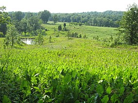
 View of Chaparral Prairie | |
Map of Ohio | |
| Location | Adams County, Ohio |
| Nearest city | West Union |
| Coordinates | 38°50′23″N 83°34′30″W / 38.8398°N 83.5749°W |
| Area | 67 acres (27 ha) |
| naturepreserves | |
Chaparral Prairie State Nature Preserve is a 67-acre (27 ha)
controlled burns
are used at Chaparral Prairie to keep woody species at bay.
Chaparral Prairie supports the most extensive population of
little bluestem is the dominant prairie grass. The rare Edward's hairstreak butterfly
has also been observed.
The preserve is open to the public, and contains a 0.75-mile (1.21 km) trail with bulletin board, interpretive signs and a parking lot.
External links
- Chaparral Prairie State Nature Preserve at ODNR Division of Natural Areas and Preserves
- Chaparral Prairie State Nature Preserve at American Byways


