
Charente-Maritime
Charente-Maritime | ||
|---|---|---|
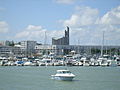
.jpg) Prefecture building in La Rochelle | ||
|
Communes 463 | | |
| ^1 French Land Register data, which exclude estuaries and lakes, ponds and glaciers larger than 1 km2 | ||
Charente-Maritime (French pronunciation:
History


Previously a part of the provinces of Saintonge and Aunis, Charente-Inférieure was one of the 83 original département created during the French Revolution on 4 March 1790.[4] On 4 September 1941, during World War II, it was renamed as Charente-Maritime.[5]
When the département was first organised, the commune of Saintes was designated as the prefecture of the département (Saintes had previously been the capital of Saintonge). This changed in 1810 when Napoleon passed an imperial decree to move the prefecture to La Rochelle.[6]
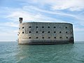
During World War II, the département was invaded by the German Army and became part of occupied France.[7] To provide defence against a possible beach landing by the Allies, the Organisation Todt constructed a number of sea defences in the area.[8] Defences such as pillboxes are particularly noticeable on the beaches of the presqu'île d'Arvert[9] and the island of Oléron.[10]
At the end of the war, the two last pockets of German resistance were both in this area: at La Rochelle in the north and Royan in the south. Despite Royan having been nearly destroyed during an RAF bombing raid on 5 January 1945,[11] the town was not liberated by the French Forces of the Interior until April of the same year.[12] La Rochelle was finally liberated on 9 May 1945.[13]
Geography

Charente-Maritime is part of the Nouvelle-Aquitaine administrative region. It is surrounded by the départements of Gironde, Charente, Deux-Sèvres, Dordogne and Vendée. It has a land area of 6864 km2 and 651,358 inhabitants as of 2019.[3]
The important rivers are the Charente and its tributaries, the Boutonne and the Seugne, along with the Sèvre Niortaise, the Seudre and the Garonne, in its downstream part, which is the estuary of the Gironde.
The département includes the islands of
The département forms the northern part of the
Administrative borders
| Direction | Neighbour |
|---|---|
| North | Vendée of Pays de la Loire and Deux-Sèvres |
| East | Charente and Dordogne |
| West | Atlantic Ocean |
| South | Gironde and Gironde estuary |
Principal towns
The most populous commune is La Rochelle, the prefecture. As of 2019, there are 7 communes with more than 8,000 inhabitants:[15]
| Commune | Population (2019) |
|---|---|
| La Rochelle | 77,205 |
| Saintes | 25,287 |
| Rochefort | 23,584 |
| Royan | 18,419 |
| Aytré | 9,247 |
| Périgny | 8,684 |
| Tonnay-Charente | 8,097 |
Climate
The climate is mild and sunny, with less than 900 mm of precipitation per year
Economy
The economy of Charente-Maritime is based on three major sectors:
During the summer months, families flock from all over Europe to bask in the sun and enjoy the local seafood. Royan, popular for its extensive beaches and attractions, is one of the most famous seaside resort of atlantic coast.
Charente-Maritime is the headquarters of the major oyster producer Marennes-Oléron.[21] Oysters cultivated here are shipped across Europe.
Rochefort is a shipbuilding site and has been a major French naval base since 1665.[22]
Demographics
The inhabitants of the département are called Charentais-Maritimes.
|
| |||||||||||||||||||||||||||||||||||||||||||||||||||||||||||||||||||||||||||||||||||||||
| ||||||||||||||||||||||||||||||||||||||||||||||||||||||||||||||||||||||||||||||||||||||||
| Sources:[24][25] | ||||||||||||||||||||||||||||||||||||||||||||||||||||||||||||||||||||||||||||||||||||||||
Politics
Departmental Council of Charente-Maritime

The President of the Departmental Council has been Dominique Bussereau (LR) since 2008.[26] He was replaced by Sylvie Marcilly after the departmental elections of June 2021.[27][28]
National representation
In the 2017 legislative election, Charente-Maritime elected the following members of the National Assembly:
In the Senate, Charente-Maritime is represented by three members: Daniel Laurent (since 2008), Corinne Imbert (since 2014) and Mickaël Vallet (since 2020).[30]
Tourism
Popular destinations include
The department is served by the TGV at Surgères and La Rochelle. It can also be reached by motorway by the A10 (E5, Paris-Bordeaux) and A837 (E602, Saintes-Rochefort).
-

-
 Royan, a seaside resort
 -
 Oyster farms on the island of Oléron
 -

-

-
-


See also
- Cantons of the Charente-Maritime department
- Communes of the Charente-Maritime department
- Arrondissements of the Charente-Maritime department
- Éclade des Moules
References
- ^ "Répertoire national des élus: les conseillers départementaux". data.gouv.fr, Plateforme ouverte des données publiques françaises (in French). 4 May 2022.
- ^ "Téléchargement du fichier d'ensemble des populations légales en 2021". The National Institute of Statistics and Economic Studies. 28 December 2023.
- ^ a b "Comparateur de territoires − Département de la Charente-Maritime (17) | Insee". www.insee.fr. Retrieved 9 July 2022.
- ^ "Doc du mois : 1790 - la naissance des Départements | La Charente-Maritime - 17". la.charente-maritime.fr (in French). Archived from the original on 9 July 2022. Retrieved 9 July 2022.
- ISSN 1760-6454. Retrieved 9 July 2022.
- ^ Annales forestières (in French). 1810. p. 341.
- ^ Combes, Jean; Luc, Albert-Michel. La Charente-Maritime dans la guerre 1939-1945 - Albert-Michel Luc (in French).
- ^ B.Fleury (30 October 2019). "Aux abords de Royan : des blockhaus qui se fondent dans le paysage". Des murs à lire (in French). Retrieved 9 July 2022.
- ^ "La libération de la poche de Royan - Le Journal des Propriétaires". www.lacotedebeaute.info. Retrieved 9 July 2022.
- ^ "Station radar de Chassiron (Ro 518 – Rebhurn)" (in French). Retrieved 9 July 2022.
- ^ "Station radar de Chassiron (Ro 518 – Rebhurn)" (in French). Retrieved 9 July 2022.
- ^ "Pourquoi Royan a été bombardé en 1945 ? - Destination Royan Atlantique". Site officiel Destination Royan Atlantique (in French). 11 May 2019. Retrieved 9 July 2022.
- ^ "La Libération de Royan avril 1945". www.c-royan.com (in French). Retrieved 9 July 2022.
- ^ "Centre Régional Résistance & Liberté - la poche de La Rochelle". www.crrl.fr (in French). 29 April 2015. Retrieved 9 July 2022.
- ^ Populations légales 2019: 17 Charente-Maritime, INSEE
- ^ Bry, Christian; Hoflack, Paul (2004). "Le bassin versant de la Charente : une illustration des problèmes posés par la gestion quantitative de l'eau" (PDF). Courrier de l'Environnement de l'INRA (52): 82 – via HAL.
- ^ Demagny, Xavier (18 June 2022). "Canicule : près de 43°C à Biarritz, de nouveaux records de chaleur battus samedi". Radio France (in French). Retrieved 9 July 2022.
- ^ "Historique météo Charente-Maritime (Juin 2022)". www.terre-net.fr. Retrieved 9 July 2022.
- ^ "Historique météo Charente-Maritime (Janvier 2022)". www.terre-net.fr. Retrieved 9 July 2022.
- ^ "Agriculture de la Charente-Maritime". charente-maritime.chambre-agriculture.fr (in French). 16 September 2021. Retrieved 9 July 2022.
- ^ "Que faire à Marennes et ses environs ?". Infiniment charentes (in French). Retrieved 9 July 2022.
- ISSN 0012-4273.
- ISSN 1760-6454. Retrieved 9 July 2022.
- ^ "Historique de la Charente-Maritime". Le SPLAF.
- ^ "Évolution et structure de la population en 2016". INSEE.
- ISSN 0242-6056. Retrieved 9 July 2022.
- ^ "Le sacre de Sylvie Marcilly, nouvelle présidente du Conseil Départemental de Charente-Maritime". France 3 Nouvelle-Aquitaine (in French). July 2021. Retrieved 9 July 2022.
- ^ "Sylvie Marcilly est la nouvelle présidente du département de la Charente-Maritime". ici, par France Bleu et France 3 (in French). 1 July 2021. Retrieved 9 July 2022.
- ^ "Charente-Maritime : Carte des circonscriptions - Assemblée nationale". www2.assemblee-nationale.fr. Retrieved 9 July 2022.
- ^ "Liste par département - Sénat". www.senat.fr. Retrieved 9 July 2022.
External links
- (in English) . Encyclopædia Britannica. Vol. 5 (11th ed.). 1911.
- (in French) Prefecture website
- (in French) Departmental Council website
- (in French) Tourism website
| International | |
|---|---|
| National | |
| Geographic | |
| Other | |