
Charlotte Amalie, U.S. Virgin Islands
Charlotte Amalie | ||
|---|---|---|
     Top: Skyline of Charlotte Amalie; Middle:Cathedral Church of All Saints, ZIP code(s) 00801–00804 | ||
| Area code | 340 | |
Charlotte Amalie (
The City is known for its Danish colonial architecture, building structure and history. Dozens of streets and places throughout the City have Danish names. Charlotte Amalie has buildings of historical importance including
Like the rest of the U.S. Virgin Islands, Charlotte Amalie has no local government and is directly administered by the
Name

Before the time of the Danish West Indies (1754–1917), the City was known as Taphus for its many beer halls. Taphus is Danish and directly translates to 'beer house', 'beer hall', or (most literally) 'tap house'. In 1691 the Town received a more respectable name by being named Charlotte Amalie in honor of Danish King Christian V's wife, Charlotte Amalie of Hesse-Kassel (1650–1714).[9] Between 1921 and 1936, the city was called St. Thomas by the United States. In 1936 the capital was recognized as Charlotte Amalie.[10]
History


Early history
On his second voyage to the
17th century
The
18th century
In the early 18th century, more than 3000 white settlers lived in Town, and sugar production and slave trading were the economic mainstay. After the Danish government wanted direct administration of the archipelago in 1754, the capital was moved from Charlotte Amalie to
In 1764, Charlotte Amalie was declared a free port by King Frederick V, and the Town became the busiest harbor in the Caribbean. The American Revolution in the 1770s was good news for the city, as it was thriving times for the local businessfolk. The Town began to be filled by immigrants from Europe, Africa and the Caribbean, most of them from other islands of the Lesser Antilles. By 1778, the Danish government had strengthened their military position by building Bluebeard's Castle and Blackbeard's Castle, lookout towers on the crests of the two hills by the city. The city prospered as a free port and United States, Danish, Sephardic, German, French, British, Italian and Spanish importing houses operated here. At the end of the 18th century, United States founding father and future architect of the United States Constitution, Alexander Hamilton, decided the Town was so wealthy that "gold moved through the streets in wheel-barrows".[15] At one point, the city of Charlotte Amalie in the Danish West Indies was the second-largest city in the Danish Realm, only smaller than the capital of Copenhagen. [16]
19th century
A growing share of the West Indian trade passed through the port in the beginning of the 1800s, and the rise of steamships made Charlotte Amalie an ideal coaling station for ships sailing between North- and South America. In 1804, Charlotte Amalie was struck by a horrendous fire that destroyed more than 1200 homes and stores throughout the town. Two more fires came in 1805 and 1806, and the densely settled town lost another thousand buildings. Neighboring islands gradually began importing coal directly from producers, and Charlotte Amalie was sidestepped in trade in the early 1800s. The abolition of slavery in 1848 further diminished Charlotte Amalie's commercial role and the town suffered from a brutal recession, as did most of the Caribbean following abolition.
During the American Civil War in the early 1860s, the town evolved into a smuggling center for ships running the federal blockade of ports in the Confederacy. As an acknowledgment of the port's smuggling success, the Danish government decided to move the capital of the archipelago back to Charlotte Amalie in 1871. The latter half of the 1800s was also soon hit by a cholera epidemic that killed thousands.[14] Charlotte Amalie fell into an unsuccessful dormancy until the United States purchased the islands from Denmark in 1917.
20th century
In 1915, the United States became interested in buying the U.S. Virgin Islands. They were concerned over German infiltration in the

When American tourists were barred from Cuba in 1960, some began visiting Charlotte Amalie instead.[17] As an unincorporated territory of the United States, the U.S. Virgin Islands became a haven for mainland United States citizens seeking luxury vacations or a second home in the Caribbean. During the mid 20th century, resorts began to be built and direct flights from the U.S. to Charlotte Amalie increased tourism. During the last half of the century, Charlotte Amalie experienced extraordinary economic growth, largely as a consequence of being a U.S. territory with a growing U.S. tourism. The tourism has not only led to a growing economy, but also to preservation and conversion of historic buildings and homes. Many ancient commercial buildings were made into restaurants and shops. During the 1980s and 90s, many buildings were restored to how they looked 200 years ago.[citation needed]
The tourism industry has thrived on the island, driving the economy of the U.S. Virgin Islands, but limited flatland space in the mountainous terrain constrains Charlotte Amalie's economic and population growth. The spread of hilltop homes overlooking the Caribbean crystal blue waters began trending in the 1960s as well.
Geography

Located mid-island on the south shore of the mountainous Island of
Charlotte Amalie is built on three low volcanic spurs called Frenchman Hill (Foretop Hill), Berg Hill (Maintop), and Government Hill (Mizzentop).[10] Charlotte Amalie is located at coordinates 18°21' north and 64°57' west.
Climate
Charlotte Amalie's average year round temperatures range from 75 to 90 °F (23.9 to 32.2 °C) and the climate is classified as a tropical savanna climate (Köppen Aw). The city has a short dry season that runs from January through March and a wet season that covers the remaining nine months, though technically June, with a monthly average precipitation of 2.35 inches or 59.7 millimeters could be considered a dry season month. While Charlotte Amalie does have a lengthy wet season, outside the months of September through November, the city generally does not see the heavy precipitation that is prevalent in many other cities with a tropical climate. The City is generally very warm and humid. Average temperatures in Charlotte Amalie are at a near constant, with average high temperatures at about 88 °F (31.1 °C) and average low temperatures at about 75 °F (23.9 °C).
| Climate data for Charlotte Amalie Airport (1991-2020 normals, extremes 1953–present) | |||||||||||||
|---|---|---|---|---|---|---|---|---|---|---|---|---|---|
| Month | Jan | Feb | Mar | Apr | May | Jun | Jul | Aug | Sep | Oct | Nov | Dec | Year |
| Record high °F (°C) | 93 (34) |
93 (34) |
94 (34) |
96 (36) |
97 (36) |
99 (37) |
98 (37) |
99 (37) |
98 (37) |
97 (36) |
95 (35) |
92 (33) |
99 (37) |
| Mean daily maximum °F (°C) | 84.1 (28.9) |
84.3 (29.1) |
84.5 (29.2) |
85.7 (29.8) |
87.2 (30.7) |
88.9 (31.6) |
89.7 (32.1) |
89.8 (32.1) |
89.2 (31.8) |
88.4 (31.3) |
86.6 (30.3) |
85.2 (29.6) |
87.0 (30.6) |
| Daily mean °F (°C) | 78.8 (26.0) |
78.9 (26.1) |
79.1 (26.2) |
80.6 (27.0) |
82.3 (27.9) |
84.1 (28.9) |
84.5 (29.2) |
84.7 (29.3) |
84.4 (29.1) |
83.3 (28.5) |
81.6 (27.6) |
80.1 (26.7) |
81.9 (27.7) |
| Mean daily minimum °F (°C) | 73.6 (23.1) |
73.5 (23.1) |
73.8 (23.2) |
75.5 (24.2) |
77.5 (25.3) |
79.3 (26.3) |
79.3 (26.3) |
79.6 (26.4) |
79.5 (26.4) |
78.3 (25.7) |
76.6 (24.8) |
74.9 (23.8) |
76.8 (24.9) |
| Record low °F (°C) | 63 (17) |
62 (17) |
60 (16) |
62 (17) |
66 (19) |
67 (19) |
66 (19) |
64 (18) |
64 (18) |
64 (18) |
61 (16) |
62 (17) |
60 (16) |
| Average rainfall inches (mm) | 2.64 (67) |
1.90 (48) |
1.86 (47) |
2.24 (57) |
3.02 (77) |
2.35 (60) |
2.91 (74) |
4.37 (111) |
5.89 (150) |
5.28 (134) |
6.06 (154) |
2.93 (74) |
41.45 (1,053) |
| Average rainy days (≥ 0.01 in) | 15.0 | 13.5 | 10.7 | 10.6 | 11.9 | 10.9 | 14.8 | 15.8 | 15.2 | 17.3 | 18.5 | 17.4 | 171.6 |
| Source: | |||||||||||||
Population
Demographics
The
A 76.2% majority are
Religion
According to the CIA World Factbook, more than 95 percent of the people describe themselves as Christians. 42% are Baptist, 34% Catholic and 17% Episcopalian.[20] There are also Jewish, Hindu and Muslim populations of European, Middle Eastern and Caribbean origin.
The city's Saints Peter and Paul Cathedral is the episcopal see of the
Saint Thomas is home to one of the oldest
Languages and literacy
More than 95 percent of the population are literate.[22]
Although English is the official language, most people speak a dialect called
are spoken by immigrants from Saba, Aruba, St. Maarten and Curacao.Economy

The economy is based on tourism, handicrafts, jewelry, and the production of rum, bay rum, and jams. As well as being the USVI's political capital, the city is the port capital of the U.S. Virgin Islands. Charlotte Amalie is the third most popular cruise ship destination in the Caribbean Sea.[25] Up to eleven cruise ships can occupy the harbor on any given day, though usually there are about five.[26]
Tourism
About 1.5 plus million cruise ship passengers visit on average per year.[27]
Tourist attractions include
Because of its duty-free policies, the Territory is sometimes referred to as "the duty-free capital of the world".[29] Charlotte Amalie has more jewelry shops and perfume vendors than anywhere else in the Caribbean and is known for its outdoor shopping Vendors' Plaza. On Main Street (Dronningens Gade) there are many major shops, including Tiffany, Breitling, Rolex, and Fresh Produce.
Culture

The culture is a mixture of American (US) socio-economic activities- and Afro/Latino-Caribbean culture, with an influence from Danish colonial history. There are American fast food chains in the City, as well as local restaurants serving only Caribbean cuisine. Grocery stores contain items from the US mainland, and local items such as rum. Seafood and local produce can be found at open-air markets.
Danish influence
Named Charlotte Amalie in honor of the wife of Danish King
Charlotte Amalie has the largest collection of colonial buildings in the Caribbean.[25] Most of the buildings are classic Caribbean adaptions of English Georgian architecture built by the Danes, dating to the 1830s.
Sport
This section needs expansion. You can help by adding to it. (March 2023) |
Transportation

There are three main roads in Charlotte Amalie. Waterfront Drive, also called Veteran's Drive, fronts the harbor and extends from Havensight Mall to Frenchtown. This four-lane road is best navigated by car or taxi. Main Street, also called Dronningen's Gade and Norre Gade, run parallel to the waterfront. Back Street, also called Wimmelskafts Gade, is one block farther inland, parallel to the shoreline. Street names in the Town are remnants of the Island's Danish past.
Charlotte Amalie is notable for being the only U.S. capital city (either of a territory or state) where traffic drives on the
Highway 30 (Veterans Drive) passes through Charlotte Amalie. Additionally, Charlotte Amalie holds one of the two airports in the US Virgin Islands. Cyril E. King Airport (IATA: STT ICAO: TIST) offers regular nonstop service to destinations to Atlanta, Chicago and along the east coast of the United States.
Education
St. Thomas-St. John School District serves the community. Addelita Cancryn Junior High School[32] and Charlotte Amalie High School serve the area. The University of the Virgin Islands, located in Charlotte Amalie, was founded in 1962.
Notable people
- Alton Adams − Lyrics writer of the Virgin Islands National Anthem and first band master of Afro-Caribbean heritage for the United States Navy
- Edward Wilmot Blyden − ambassador and is credited by some as having laid the foundation of West African nationalism or Pan-Africanism
- Callix Crabbe − Major League Baseball player
- Hannah Davis− fashion model
- Kelsey Grammer − actor, director and producer
- Emile Griffith − boxer who won world championships in the Welterweight and Middleweight divisions
- Alexander Hamilton − born in neighboring island of Nevis; moved to the Danish West Indies (present-day U.S. Virgin Islands), where he grew up[33]
- Elrod Hendricks − Major League Baseball player
- Julian Jackson − boxer
- J. Raymond Jones − political activist
- Al McBean − Major League Baseball player
- Alonzo G. Morón (1909–1971), university president, educator, and civil servant; born in Charlotte Amalie, Danish West Indies (present-day U.S. Virgin Islands)[34]
- Ralph Moses Paiewonsky − governor
- Calvin Pickering − Major League Baseball player
- pornographic actress
- Charles Sainte-Claire Deville − French geologist
- Henri Sainte-Claire Deville − French chemist
- Camille Pissarro − a key member of the French Impressionist painters
- Rashawn Ross − trumpeter who tours with Dave Matthews Band
- Roy Lester Schneider− governor and physician
- Morris Simmonds − German physician and pathologist
- Karrine Steffans − New York Times best-selling author
- Terence Todman − ambassador
- Denmark Vesey − leader of planned slave uprising in Charleston, South Carolina
- Peter von Scholten − governor general
- David Levy Yulee − first Jewish member of the United States Senate
Gallery
-
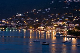 Saint Thomas Harbor at night
 -
-
 Charlotte Amalie from a Dronningens Quarter overlook
 -
 Bunker Hill (Commandant Gade), 1941
 -
 Overlooking town from Skyline Drive
 -
 Harbor and Havensight view from Bluebeard's, 1980
 -
 Conch Blower statue, Emancipation Garden
 -
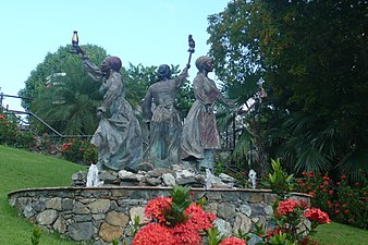 Three Queens Fountain, Blackbeard's Castle
 -
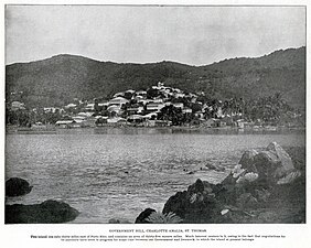 Charlotte Amalie, 1899
 -
 Steps made from the ballast bricks of the tall ships coming from the Old World


References
- ^ "Puerto Rico and the Outlying Areas" (PDF). Geographic Areas Reference Manual. Bureau of the Census. 1994. p. 38-40. Retrieved May 9, 2023.
The only functioning governmental unit in the Virgin Islands is the territorial government.
- ^ "How to Pronounce Charlotte Amalie (Real Life Examples!)". YouTube.
- ^ "The History of St. Thomas, US Virgin Islands". Stthomasusvi.thebeach.vi. Retrieved January 11, 2014.
- ^ "Census Bureau Releases Census 2000 Population Counts for the U.S. Virgin Islands". U.S. Census Bureau. July 3, 2001. Archived from the original on November 18, 2001. Retrieved December 6, 2017.
- ^ ALDETH LEWIN (Daily News Staff) (August 25, 2011). "Census shows V.I.'s population down 2% - News". Virgin Islands Daily News. Archived from the original on April 12, 2013. Retrieved January 11, 2014.
- ^ "National Historic Landmarks Program". National Park Service. Retrieved January 28, 2012.
- ^ "St. Thomas Attractions: Historic Sites in Charlotte Amalie (Kongen's Quarter)". Vinow.com. Retrieved January 11, 2014.
- ^ "Puerto Rico and the Outlying Areas" (PDF). Geographic Areas Reference Manual. Bureau of the Census. 1994. p. 38-41. Retrieved May 9, 2023.
The only functioning governmental unit in the Virgin Islands is the territorial government.
- OCLC 769428814.
- ^ a b "Charlotte Amalie (United States Virgin Islands) - Encyclopædia Britannica". Britannica.com. August 27, 2012. Retrieved January 11, 2014.
- OCLC 519725469.
- ^ Henighan, Susanna (September 21, 2012). "Early Peoples of the Virgin Islands - Moon Travel Guides". Moon.com. Archived from the original on July 30, 2012. Retrieved January 11, 2014.
- ^ "The History of St. Thomas, US Virgin Islands". thebeach.vi.
- ^ OCLC 214322934.
- OCLC 62860795.
- OCLC 1028514642.
- ^ "A Brief History of the Danish West Indies, 1666-1917". Archived from the original on December 4, 2008. Retrieved 2009-04-30.
- ^ "NowData - NOAA Online Weather Data". National Oceanic and Atmospheric Administration. Retrieved June 17, 2021.
- ^ "Station: Charlotte Amalie AP, VI VQ". U.S. Climate Normals 2020: U.S. Monthly Climate Normals (1991-2020). National Oceanic and Atmospheric Administration. Retrieved June 17, 2021.
- ^ a b "The World Factbook". Cia.gov. Retrieved January 11, 2014.
- ^ "Chabad Lubavitch Jewish Center of the Virgin Islands – Your Soul Resort In America's paradise". Jewishvirginislands.com. Archived from the original on November 27, 2012. Retrieved December 13, 2012.
- ^ "The World Factbook". cia.gov. May 11, 2022.
- ^ "Detailed Tables – American FactFinder". United States Census Bureau. Retrieved January 11, 2011.[dead link]
- ^ "Îles Vierges américaines". Tlfq.ulaval.ca. Archived from the original on January 17, 2013. Retrieved January 11, 2014.
- ^ OCLC 47942278.
- ^ "Yahoo Travel". yahoo.com. Archived from the original on October 27, 2014. Retrieved August 25, 2014.
- ^ "St. Thomas Photos - Worldatlas.com". worldatlas.com. Archived from the original on August 26, 2014. Retrieved August 25, 2014.
- ISBN 9781588433534.
- ^ "Charlotte Amalie, St. Thomas - Royal Caribbean International". Royalcaribbean.com. Retrieved January 11, 2014.
- ^ "Virgin Island History". Virgin-islands-history.dk. March 31, 1917. Archived from the original on November 13, 2013. Retrieved 2014-01-11.
- ^ "Some words used in Virgin Islands English Creole, compiled by Sara Smollett, 2011" (PDF). Archived from the original (PDF) on March 4, 2016. Retrieved March 20, 2013.
- ^ "Addelita Cancryn Junior High School". Archived from the original on April 9, 2008. Retrieved April 24, 2008.
- OCLC 49751010.
- . Retrieved March 9, 2023.
External links
 Media related to Charlotte Amalie at Wikimedia Commons
| International | |
|---|---|
| National | |
| Geographic | |
| Other | |