
Chetpet (Chennai)
(Redirected from
Chetput (Chennai)
)
Chetpet | |
|---|---|
neighbourhood | |
UTC+5:30 (IST) | |
| Planning agency | CMDA |
Chetpet is a neighbourhood in the
Ramanujan died.[1]
History
Along with Egmore and Nungambakkam, Chetpet is considered one of the original villages merged by the British to form Chennai.[2][3][4]
Development
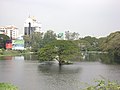
Until recently, the waters of
Chetpet lake supplied groundwater recharge for the surrounding neighbourhoods.[5]
Location – Chetpet
Chetpet is located at the center of Chennai, not far from Egmore railway station. CMBT is 8 km from Chetpet.Chetpet Eco Park is a famous landmark in this loacality.
Educational institutions
- Auxilium Girls Higher Secondary School
- Lady Andal Venkata Subba Rao Matriculation School
- Madras Christian College Higher Secondary School
- Madras Christian College Matriculation Higher Secondary School
- Maharishi Vidya Mandir Senior Secondary School
- Sherwood Hall Senior Secondary School
- The Madras Seva Sadan Higher Secondary School
- Union Christian Matriculation Higher Secondary School
Gallery
-
 Chetpet village in 1905
 -

-

-
-
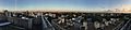 Chetpet View


Location in context
Areas of Chennai | ||||||||||||||||
|---|---|---|---|---|---|---|---|---|---|---|---|---|---|---|---|---|
| ||||||||||||||||
References
Wikimedia Commons has media related to Chetput.
- ^ "Squaring the circle". The Hindu. Vol. 132, no. 102. 23 April 2006. p. 3. Retrieved 18 September 2016.
- ^ History of Chennai
- ^ Nungambakkam
- ^ Dinamalar.com "சென்னையும் சிவப்பு நிற கட்டடங்களும்"[permanent dead link]
- ^ Lakshmi, K. (30 April 2009). "Hyacinth robbing Chetpet lake of life". The Hindu. Vol. 132, no. 102. p. 3. Archived from the original on 3 May 2009. Retrieved 1 May 2009.
