
Chittor Fort
| Chittor Fort | |
|---|---|
| Part of Sisodias of Mewar | |
South Asia |
The Chittorgarh (literally Chittor Fort), also known as Chittod Fort, is one of the largest living forts in
In 2013, at the 37th session of the World Heritage Committee held in Phnom Penh, Cambodia, Chittorgarh Fort, along with five other forts of Rajasthan, was declared a UNESCO World Heritage Site, as a group called the Hill Forts of Rajasthan
Geography

Chittorgarh, located in the southern part of the state of Rajasthan, 233 km (144.8 mi) from Ajmer, midway between Delhi and Mumbai on National Highway 8 in the road network of Golden Quadrilateral. Chittorgarh is situated where National Highways No. 76 and 79 intersect.
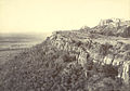
The fort rises abruptly above the surrounding plains and is spread over an area of 2.8 km2 (1.1 sq mi). The fort stands on a hill 180 m (590.6 ft) high.
The fort that once boasted of 84 water bodies has only 22 of them now. These water bodies are fed by natural catchment and rainfall, and have a combined storage of 4 billion litres that could meet the water needs of an army of 50,000. The supply could last for four years. These water bodies are in the form of ponds, wells and step wells.[6]
History

Chittorgarh (garh means fort) was originally called Chitrakut.[9] It is said to have been built by western branch of Mauryan ruler Chitrangada Mori.[10] According to one legend, the name of the fort is derived from its builder.[9] Several small Buddhist stupas dated to 9th century based on the script were found at the edge of Jaimal Patta lake.[11][12]

The
Chittor was known as " Chit-
Siege of 1303


In 1303, the
Alauddin assigned Chittorgarh to his young son Khizr Khan (or Khidr Khan), and the Chittor fort was renamed "Khizrabad" after the prince. As Khizr Khan was only a child, the actual administration was handed over to a slave named Malik Shahin.[26]
Rana Hammir and successors
Khizr Khan's rule at the fort lasted till 1311 AD and due to the pressure of
Rana Kumbha and clan
There was resurgence during the reign of Rana Kumbha in the 15th century. Rana Kumbha, also known as Maharana Kumbhakarna, son of
] After Raimal's death in May 1509, Sangram Singh (also known as Rana Sanga), his younger son, became the ruler of Mewar, which brought in a new phase in the history of Mewar.Chittorgarh Under Rana Sanga
Rana Sanga was taken away from the battlefield in an unconscious state by his vassals Prithviraj Singh I of Jaipur and Maldeo Rathore of Marwar. After regaining consciousness he took an oath to never return to Chittorgarh until he defeated Babur and conquer Delhi. He also stop wearing turban and used to wrap a cloth over his head.[37] While he was preparing to wage another war against Babur he was poisoned by his own nobles who did not want another battle with Babur. He died in Kalpi in January 1528.[38]
After his defeat his vassal Medini Rai was defeated by Babur at Battle of Chanderi and Babur captured the capital of Rai kingdom Chanderi. Medini was offered Shamsabad instead of Chanderi as it was historically important in conquering Malwa but Rai refused the offer and chose to die fighting. The Rajput women and children committed self-immolation to save their honour from Muslim army. After the victory, Babur captured Chanderi along with Malwa which was ruled by Rai.[39]
Post Rana Sanga
Siege of 1535
Siege of 1567
The final Siege of Chittorgarh came 33 years later, in 1567, when the Mughal Emperor Akbar attacked the fort. Akbar wanted to conquer Mewar, which was being ruled by Rana Uday Singh II to gain easy access to the Gujarati ports and establish a trade route.
Shakti Singh, son of the Rana who had quarreled with his father, had run away and approached Akbar when the later had camped at Dholpur preparing to attack Malwa. During one of these meetings, in August 1567, Shakti Singh deduced from a remark made in jest by emperor Akbar that he intended to wage war against Chittorgarh. Akbar had told Shakti Singh in jest that since his father had not submitted himself before him like other princes and chieftains of the region he would attack him. Startled by this revelation, Shakti Singh quietly rushed back to Chittorgarh and informed his father of the impending invasion by Akbar. Akbar was furious with the departure of Shakti Singh and decided to attack Mewar to humble the arrogance of the Ranas.[40]
In September 1567, the emperor left for Chittorgarh, and on 20 October 1567, camped in the vast plains outside the fort. In the meantime, Rana Udai Singh, on the advice of his council of advisors, decided to go away from Chittor to the hills of
On 22 February 1568, Jaimal was killed by a musket shot fired by Akbar himself.[citation needed] Jauhar was committed in the houses of Patta, Aissar Das, and Sahib Khan. The next day the gates of the fort were opened and Rajput soldiers rushed out to fight the enemies. In the ensuing battle, the army of Chittorgarh were killed alongside 20,000–25,000 civilians and Chittorgarh was conquered.
Mughal–Rajput peace treaty of 1615
In 1615, after a treaty between Jahangir and Amar Singh, Chittorgarh was given back to Amar Singh by Jahangir.[41][page needed]
The fort was refurbished in 1905 during British Raj.[42]
Precincts

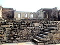
The fort, which is roughly in the shape of a fish, has a circumference of 13 km (8.1 mi) with a maximum length of 5 km (3.1 mi) and it covers an area of 700 acres.[43] The fort is approached through a difficult zig-zag ascent of more than 1 km (0.6 mi) from the plains, after crossing over a limestone bridge. The bridge spans the Gambhiri River and is supported by ten arches (one has a curved shape while the balance have pointed arches). Apart from the two tall towers, which dominate the majestic fortifications, the sprawling fort has a plethora of palaces and temples (many of them in ruins) within its precincts.[44][4]
The 305 hectare component site, with a buffer zone of 427 hectares, encompasses the fortified stronghold of Chittorgarh, a spacious fort located on an isolated rocky plateau of approximately 2 km length and 155 m width.
It is surrounded by a perimeter wall 13 km (8.1 mi) long, beyond which a 45° hill slope makes it almost inaccessible to enemies. The ascent to the fort passes through seven gateways built by the Mewar ruler Rana Kumbha (1433–1468) of the
The fort complex comprises 65 historic built structures, among them 4 palace complexes, 19 main temples, 4 memorials, and 20 functional water bodies. These can be divided into two major construction phases. The first hill fort with one main entrance was established in the 5th century and successively fortified until the 12th century. Its remains are mostly visible on the western edges of the plateau. The second, more significant defence structure was constructed in the 15th century during the reign of the Sisodia Rajputs, when the royal entrance was relocated and fortified with seven gates, and the medieval fortification wall was built on an earlier wall construction from the 13th century.

Besides the palace complex, located on the highest and most secure terrain in the west of the fort, many of the other significant structures, such as the Kumbha Shyam Temple, the

Although the majority of temple structures represent the Hindu faith, most prominently the Kalikamata Temple (8th century), the Kshemankari Temple (825–850) the Kumbha Shyam Temple (1448) or the Adbuthnath Temple (15th–16th century), the hill fort also contains
Gates

The fort has total seven gates (in local language, gate is called Pol) in the west, namely the Padan Pol, Bhairon Pol, Hanuman Pol, Ganesh Pol, Jodla Pol, Laxman Pol, and the main gate named the Ram Pol (Lord Rama's Gate). All the gateways to the fort have been built as massive stone structures with secure fortifications for military defense. The doors of the gates with pointed arches are reinforced to fend off elephants and cannon shots. The top of the gates has notched parapets for archers to shoot at the enemy army. A circular road within the fort links all the gates and provides access to the numerous monuments (ruined palaces and 130 temples) in the fort.
On the right of Suraj Pol is the Darikhana or Sabha (council chamber) behind which lie a Ganesha temple and the zenana (living quarters for women). A massive water reservoir is located towards the left of Suraj Pol. There is also a peculiar gate, called the Jorla Pol (Joined Gate), which consists of two gates joined. The upper arch of Jorla Pol is connected to the base of Lakshman Pol. It is said[by whom?] that this feature has not been noticed anywhere else in India. The Lokota Bari is the gate at the fort's northern tip, while a small opening that was used to hurl criminals into the abyss is seen at the southern end.[2][3][4][45]
Vijaya Stambha

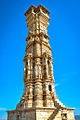
The Vijaya Stambha (Tower of Victory) or Jaya Stambha, called the symbol of Chittorgarh and a particularly bold expression of triumph, was erected by Rana Kumbha between 1458 and 1468 to commemorate his victory over Mahmud Shah I Khalji, the Sultan of Malwa, in 1440 AD.[citation needed] Built over a period of ten years, it rises 37.2 metres (122 ft) over a 47 square feet (4.4 m2) base in nine stories accessed through a narrow circular staircase of 157 steps (the interior is also carved) up to the 8th floor, from where there is good view of the plains and the new town of Chittorgarh.[citation needed] The dome, which was a later addition, was damaged by lightning and repaired during the 19th century. The Stambha is now illuminated during the evenings and gives a beautiful view of Chittorgarh from the top.[2][44][4][46]

Kirti Stambha
Kirti Stambha (Tower of Fame) is a 22-metre-high (72 ft) tower built on a 30-foot (9.1 m) base with 15 feet (4.6 m) at the top; it is adorned with
Rana Kumbha Palace
Rana Kumbha's palace (in ruins) is located at the entrance gate near the Vijaya Stamba. The palace included elephant and horse stables and a temple to Lord
Fateh Prakash Palace
Located near Rana Khumba palace, built by Rana Fateh Singh, the precincts have modern houses and a small museum. A school for local children (about 5,000 villagers live within the fort) is also nearby.[2][4]
Gaumukh Reservoir

A spring feeds the tank from a carved cow's mouth in the cliff. This pool was the main source of water at the fort during the numerous sieges.[4]
Padmini's Palace
Padmini's Palace or Rani Padmini's Palace is a white building and a three storied structure (a 19th-century reconstruction of the original). It is located in the southern part of the fort.
Other sights

Close to Vijay Sthamba is the Meera Temple, or the Meerabai Temple. Rana Khumba built it in an ornate Indo-Aryan architectural style. It is associated with the mystic saint-poet Mirabai who was an ardent devotee of Lord Krishna and dedicated her entire life to His worship. She composed and sang lyrical bhajans called Meera Bhajans. The popular legend associated with her is that with blessings of Krishna, she survived after consuming poison sent to her by her evil brother-in-law. The larger temple in the same compound is the Kumbha Shyam Temple (Varaha Temple).[2][3][4] The pinnacle of the temple is in pyramid shape. A picture of Meerabai praying before Krishna has now been installed in the temple.[50]
Across from Padmini's Palace is the Kalika Mata Temple. Originally, a Sun Temple dated to the 8th century dedicated to Surya (the Sun God) was destroyed in the 14th century. It was rebuilt as a Kali temple.[2][3][4]
Another temple on the west side of the fort is the old
Culture
The fort and the city of Chittorgarh host the biggest Rajput festival called the "Jauhar Mela".[1] It takes place annually on the anniversary of one of the jauhars, but no specific name has been given to it. It is generally believed that it commemorates Padmavati's jauhar, which is most famous. This festival is held primarily to commemorate the bravery of Rajput ancestors and all three jauhars which happened at Chittorgarh Fort. A huge number of Rajputs, which include the descendants of most of the princely families, hold a procession to celebrate the Jauhar. It has also become a forum to air one's views on the current political situation in the country.[52]
Six forts of Rajasthan, namely,
The ruined city of the Cold Lairs from
Gallery
-
 Columns in the fortress.
 -
 A part of the fortress.
 -
 Fort remains 1
 -
 Fort remains 2
 -
 Padmini Palace
 -
 Interiors of the Padmini Palace.
 -
 Structures in the fort 1
 -
 Structures in the fort 2
 -
 MeeraTemple
 -
-
 Jain temple at Kirtistambha


References
- ^ a b "The Fantastic 5 Forts: Rajasthan Is Home to Some Beautiful Forts, Here Are Some Must-See Heritage Structures". DNA : Daily News & Analysis. 28 January 2014. Archived from the original on 24 September 2015. Retrieved 5 July 2015.
- ^ )
- ^ a b c d e f "Indian States and Union Territories". Places of Interest in Rajasthan: Chtiiorgarh. Retrieved 24 June 2009.
- ^ a b c d e f g h i j k "Chittorgarh Fort of Rajasthan in India". Archived from the original on 4 June 2009. Retrieved 22 June 2009.
- ^ "Places and Monuments". Archived from the original on 17 July 2009. Retrieved 24 June 2009.
- ^ "Rajasthan's Water fort". Rainwaterharvesting.Org. Retrieved 24 June 2009.
- .
- ^ Epigraphia Indica Vol 34. pp. 53–58.
- ^ a b c Paul E. Schellinger & Robert M. Salkin 1994, p. 191.
- ^ Shiv Kumar Tiwari 2002, p. 271.
- ^ Chittorgarh, Shobhalal Shastri, 1928, pp. 64-65
- ^ "Hill Forts of Rajasthan".
- ^ a b R. C. Majumdar 1977, p. 298-299.
- ^ Ram Vallabh Somani 1976, p. 45.
- ^ Ram Vallabh Somani 1976, p. 44.
- ^ D. C. Ganguly 1957, p. 90.
- ^ Al-Hind the Making of the Indo-Islamic World, p. 230
- ^ Al-Hind The Making of the Indo-Islamic World · Volume 1, p. 230
- ^ The History of India, as Told by Its Own Historians, p. 370
- ^ Tabakat-i-Nasiri, p. 124
- ^ Banarsi Prasad Saksena 1992, p. 366.
- ^ Banarsi Prasad Saksena 1992, p. 367.
- ^ Kishori Saran Lal 1950, pp. 119–120.
- ^ Satish Chandra 2004, p. 89.
- ^ Kishori Saran Lal 1950, p. 130.
- ^ a b Banarsi Prasad Saksena 1992, p. 368.
- ^ a b Ishwari Prasad. "A Short History of Muslim Rule in India". India in the sixteenth century. The Indian Press, Ltd. pp. paras 281 to 287. Retrieved 22 June 2009.
- ^ History of Rajasthan by Deryck O.Lodrick
- ^ Sharma 1954, p. 17.
- ^ Chaurasia 2002, pp. 156–157.
- ^ Sharma 1954, p. 18.
- ^ Sharma 1954, p. 19.
- ^ Sharma 1954, p. 34.
- ^ Rao 1991, p. 452.
- ^ Sharma 1954, p. 8.
- ^ Rao 1991, p. 453-454.
- ^ Sharma 1954, pp. 43.
- ^ Sharma 1954, pp. 44.
- ^ Chaurasia 2002, p. 157.
- ^ "Akbarnama by Abu'l Fazl: H.M.'s Siege of the Fortress of Citur". Archived from the original on 14 August 2017. Retrieved 19 August 2022.
- ^ Chandra 2006.
- ^ "Chittorgarh – The Largest Fort In India". The Mysterious India. 18 December 2015. Retrieved 18 November 2021.
- ^ "Chittorgharh Tourism: Places to Visit, Tourist Places & Chittor Fort - Rajasthan Tourism". www.tourism.rajasthan.gov.in. Retrieved 13 September 2021.
- ^ a b c "Chittorgarh Fort". Retrieved 24 June 2009.
- )
- ^ "Tower of Victory, Chittore Fort". Archived from the original on 16 October 2012. Retrieved 21 June 2009.
- ^ "The Khowasin Stambha, a Jaina tower at Cheetore". Archived from the original on 16 October 2012. Retrieved 23 June 2009.
- ^ "Chittaurgarh Fort, Chittaurgarh". Archived from the original on 7 February 2009. Retrieved 24 June 2009.
- ^ Ranchor Bhatt 1985, p. 186.
- )
- ^ "Chittorgharh Tourism: Places to Visit, Tourist Places & Chittor Fort - Rajasthan Tourism". www.tourism.rajasthan.gov.in. Retrieved 13 September 2021.
- )
- ^ "Heritage Status for Forts". Eastern Eye. 28 June 2013. Archived from the original on 24 September 2015. Retrieved 5 July 2015.
- ^ "Iconic Hill Forts on UN Heritage List". New Delhi, India: Mail Today. 22 June 2013. Archived from the original on 24 September 2015. Retrieved 5 July 2015.
- ^ "Kaa's Hunting – Notes on the text". The Kipling Society. 4 May 2021. Retrieved 14 February 2022.
- ^ "Seeonee: The Site of Mowgli's Jungle?". The Kipling Society. 17 June 2021. Retrieved 14 February 2022.
Bibliography
- ISBN 978-81-7212-001-6.
- Chaurasia, Radhey Shyam (2002). History of Medieval India: From 1000 A.D. to 1707 A.D. Atlantic Publishers & Dist. ISBN 978-81-269-0123-4.
- Sharma, Gopi Nath (1954). Mewar & the Mughal Emperors (1526-1707 A.D.). S.L. Agarwala.
- OCLC 31870180.
- D. C. Ganguly (1957). "Northern India During The Eleventh and Twelfth Centuries". In OCLC 26241249.
- G.H.R Tillotson (1987) [1987]. The Rajput Palaces - The Development of an Architectural Style (Hardback) (First ed.). New Haven and London: Yale University Press. p. 224 pages. ISBN 0-300-03738-4.
- George Michell; Antonio Martinelli (2005) [2005]. The Palaces of Rajasthan. London: Frances Lincoln. p. 271 pages. ISBN 978-0-7112-2505-3.
- OCLC 685167335.
- Paul E. Schellinger; Robert M. Salkin, eds. (1994). International Dictionary of Historic Places: Asia and Oceania. Vol. 5. Routledge/Taylor & Francis. ISBN 9781884964046.
- R. C. Majumdar (1977). Ancient India. Motilal Banarsidass. ISBN 9788120804364.
- Ram Vallabh Somani (1976). History of Mewar, from Earliest Times to 1751 A.D. Mateshwari. OCLC 2929852.
- Satish Chandra (2004). Medieval India: From Sultanat to the Mughals-Delhi Sultanat (1206-1526). Vol. 1. Har-Anand Publications. ISBN 9788124110645.
- Chandra, Satish (2006). Medieval India: From Sultanat to the Mughals (1206–1526). Vol. 2. Har-Anand Publications.
- Shiv Kumar Tiwari (2002). Tribal Roots of Hinduism. Sarup & Sons. ISBN 9788176252997.
- Viven Crump; Irene Toh (1996). Rajasthan (hardback). New York: Everyman Guides. p. 400. ISBN 1-85715-887-3.
- Ranchor Bhatt (1985). Amar Kavyam (hardback). Udaipur: Sahitya Sansthan, Rajasthan Vidyapeeth.
External links
 Media related to Chittor Fort at Wikimedia Commons
 Chittorgarh travel guide from Wikivoyage
| North |
|  |
|---|---|---|
| East | ||
| Northeast | ||
| South | ||
| Central | ||
West |
| |