
Chungará Lake
| Chungará Lake | |
|---|---|
| Chungara | |
seepage | |
| Catchment area | 260 square kilometres (100 sq mi) |
| Max. length | 8.75 kilometres (5.44 mi) |
| Surface area | 21.5–22.5 square kilometres (8.3–8.7 sq mi) |
| Max. depth | 26–40 metres (85–131 ft) |
| Surface elevation | 4,517 metres (14,820 ft) |
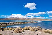
Chungará is a lake situated in the extreme north of Chile at an elevation of 4,517 metres (14,820 ft), in the Altiplano of Arica y Parinacota Region in the Lauca National Park. It has a surface area of about 21.5–22.5 square kilometres (8.3–8.7 sq mi) and has a maximum depth of about 26–40 metres (85–131 ft). It receives inflow through the Río Chungara with some minor additional inflows, and loses most of its water to evaporation; seepage into the Laguna Quta Qutani plays a minor role.
The lake formed between 8,000 and 17,000 years ago when the volcano
Name
The name Chungará or Chungara is derived from the Aymara language and has several different meanings: Chunka, a type of bush or moss plus the suffix ra that signifies "covered by"; but this meaning appears to have fallen into disuse. A second meaning is Chunkha "beard" which together with the suffix means "bearded" and refers to a myth of a bearded man that came to the area and destroyed a community[2] with fire.[3]
Geography
Chungará Lake is located in the northernmost part of Chile and close to the border with
The lake is about 8.75 kilometres (5.44 mi) wide[10] and covers an irregular surface of about 21.5 square kilometres (8.3 sq mi)[11]-22.5 square kilometres (8.7 sq mi),[12] with two large embayments in the northeastern and the southern sectors of the lake and a narrower one in its northwestern corner. Its deepest point is 26 metres (85 ft)[1]-40 metres (130 ft) deep[12] and lies in the northwestern sector of the lake.[7] The northern and western side of the lake have steep shores, while the southern and eastern ones are much more gentle;[10] the eastern shore is covered by a large alluvial fan[13] and the southern one by sediments deposited by the Río Chungara tributary.[10] The lake floor features platforms, flat areas and sloping areas.[14] 4 kilometres (2.5 mi) northwest from Chungará Lake lies the Lagunas Cotacotani.[15]
The volcanoes

Hydrology

The water temperature reaches its maximum during March with 13.5 °C (56.3 °F) and a minimum in January with 3.5 °C (38.3 °F) according to one study,[17] while temperatures on the lake floor range between 6.4–6.2 °C (43.5–43.2 °F).[18] Water levels vary by 0.5 metres (1 ft 8 in) between seasons[1] and fluctuations of 3–2 metres (9.8–6.6 ft) have been recorded.[19]
The present-day water levels are the highest in the history of the lake and there is no evidence of former lake highstands,
The Lake Chungará is part of a 260 square kilometres (100 sq mi)
Chungará Lake has no
The total volume of the lake is about 0.426 cubic kilometres (0.102 cu mi). Chungará Lake is
Geology
The lake was formed by volcanic-tectonic phenomena;
Volcanism in the area has been ongoing since the Paleozoic[1] and has continued until recent times, which has influenced Chungará Lake.[34] A number of volcanoes such as Parinacota, Ajoya and Quisiquisini grew on a Miocene ignimbrite basement that crops out east of the lake;[11] of these only Parinacota has been active in the Holocene, depositing tephra within the lake.[18]
Climate
Temperatures at the lake average 4.2 °C (39.6 °F),
Human use
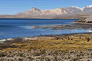
The area of the lake is inhabited by Aymara people who engage in animal husbandry, using alpacas, cattle, llamas and sheep and live on farms and pastoral refuges.[6]
-
 The marina of Chungará Lake
 -
 Road and roadsign on Chungará Lake
 -
 Road on Chungará Lake
.jpg)

.jpg)
Environmental issues
In the 1970s water was pumped from Chungará Lake to the Azapa Valley to allow for irrigation, but quickly ceased when water levels dropped and the flora and fauna of the lake were damaged.[9] For this purpose, the Canal Chungará was built by the Chilean Ministry of Public Works to transfer water into the Laguna Cotacotani which is the headwater of the Lauca-Azapa system.[22]
This project was opposed by environmentalists.
Accumulation of rubbish in the area of Chungará Lake has become a major issue, as a lot of waste is discarded by for example drivers on the Chungara–Tambo Quemado road between Chile and Bolivia. The Chilean government has thus organized cleanup operations to remove some of the waste.[40]
Biology
The lake hosts a diverse plant and animal community.
The shoreline vegetation draws birds in such as Andean gull, Chilean flamingo, crested duck, giant coot and Puna plover.[40][41]
-
 Birdlife, including Chilean flamingo, at Chungará Lake
 -
 Shoreline vegetation and landscape

.jpg)
Aided by the highly transparent waters,
The
Fish
The most important and only native fish in Chungará Lake are two endemics; the pupfish Orestias chungarensis and catfish Trichomycterus chungaraensis.[41][43]
Orestias chungarensis of Chungará Lake is most closely related to other
The rainbow trout also lives in the lake and is considered an invasive species there as it feeds on the threatened Orestias fish; the Chilean government has thus envisaged to take measures to eradicate the fish from the lake.[46]
See also
References
- ^ a b c d e f g h i Mühlhauser et al. 1995, p. 342.
- ^ Mamani 1994, p. 119.
- ^ Mamani 1994, p. 121.
- ^ "Región de Arica y Parinacota" (in Spanish). Servicio de Evaluación Ambiental. Retrieved 10 November 2018.
- ^ ISSN 0366-1644.
- ^ a b c Mamani 1994, p. 118.
- ^ a b c Pueyo et al. 2011, p. 341.
- ISSN 0716-078X.
- ^ a b c Herrera et al. 2010, p. 300.
- ^ a b c Hernández et al. 2008, p. 352.
- ^ a b c d Herrera et al. 2010, p. 306.
- ^ a b c d e f g h i j Moreno et al. 2007, p. 5.
- ^ a b c d Sáez et al. 2007, p. 1215.
- ^ a b c d e Sáez et al. 2007, p. 1195.
- ^ División de estudios y planificación 2010, p. 38.
- ^ a b c d Sáez et al. 2007, p. 1193.
- ^ Mühlhauser et al. 1995, p. 343.
- ^ a b c d Sáez et al. 2007, p. 1194.
- ^ a b c d e f g Pueyo et al. 2011, p. 340.
- ^ Sáez et al. 2007, pp. 1217–1218.
- ^ Sáez et al. 2007, p. 1220.
- ^ a b c d e División de estudios y planificación 2010, p. 17.
- ^ a b c d Niemeyer, Hans F. "HOYAS HIDROGRÁFICAS DE CIDLE : PRIMERA REGIÓN" (PDF) (in Spanish). DIRECC!ON GENERAL DE AGUAS. p. 95. Archived from the original (PDF) on 11 November 2018. Retrieved 11 November 2018.
- ^ Sáez et al. 2007, p. 1214.
- ^ Herrera et al. 2010, p. 309.
- ^ Herrera et al. 2010, p. 316.
- ^ Hernández et al. 2008, p. 361.
- ^ a b Mühlhauser et al. 1995, p. 347.
- ^ Herrera et al. 2010, p. 308.
- ^ Sáez et al. 2007, pp. 1199–1200.
- ^ Sáez et al. 2007, p. 1218.
- ^ Sáez et al. 2007, p. 1196.
- ^ Sáez et al. 2007, p. 1219.
- ^ Moreno et al. 2007, p. 16.
- ^ Mühlhauser et al. 1995, p. 346.
- ISSN 0717-9707.
- ^ a b División de estudios y planificación 2010, p. 18.
- ISSN 0718-6851.
- ^ División de estudios y planificación 2010, p. 5.
- ^ a b "Más de 30 toneladas de basura son extraídas en operativo de limpieza del Lago Chungará" (in Spanish). División de Gobierno Interior. 21 April 2016. Retrieved 10 November 2018.
- ^ a b c d Mühlhauser et al. 1995, p. 344.
- ^ Mühlhauser et al. 1995, p. 348.
- ^ Vila et al. 2013, p. 931.
- ^ Vila et al. 2013, p. 938.
- ^ "Conociendo los peces de Bolivia: Las ninfas de las montañas (Orestias spp.): Peces que habitan el Altiplano de Bolivia" (in Spanish). Museo Nacional de Historia Natural de Bolivia. 6 July 2017. Retrieved 10 November 2018.
- ^ a b "Acuerdan medidas para erradicar trucha arcoiris del lago Chungará" (in Spanish). Subsecretaría de Pesca y Acuicultura. 9 November 2015.
Sources
- División de estudios y planificación (October 2010). "PLAN DE ACCIÓN ESTRATÉGICO PARA EL DESARROLLO HIDRICO DE LA REGIÓN DE ARICA Y PARINACOTA" (PDF) (in Spanish). Santiago: DIRECCION GENERAL DE AGUAS. Archived from the original (PDF) on 3 August 2016. Retrieved 11 November 2018.
- Hernández, Armand; Bao, Roberto; Giralt, Santiago; Leng, Melanie J.; Barker, Philip A.; Sáez, Alberto; Pueyo, Juan J.; Moreno, Ana; Valero-Garcés, Blas L.; Sloane, Hilary J. (2008). "The palaeohydrological evolution of Lago Chungará (Andean Altiplano, northern Chile) during the Lateglacial and early Holocene using oxygen isotopes in diatom silica". Journal of Quaternary Science. 23 (4): 351–363. S2CID 55897264.
- Herrera, Christian; Pueyo, Juan Jose; Saez, Alberto; Valero-Garces, Blas L. (30 June 2010). "Relation of surface and underground waters in Chungará and Cotacotani lake districts, northern Chile: an isotopic study". Andean Geology (in Spanish). 33 (2): 299–326. ISSN 0718-7106.
- Mamani, Manuel M. (1994). "Antecedentes Míticos y Ecológicos del Significado del Vocablo Chungara". Chungara: Revista de Antropología Chilena. 26 (1): 117–124. JSTOR 27801993.
- Moreno, A.; Giralt, S.; Valero-Garcés, B.; Sáez, A.; Bao, R.; Prego, R.; Pueyo, J.J.; González-Sampériz, P.; Taberner, C. (February 2007). "A 14kyr record of the tropical Andes: The Lago Chungará sequence (18°S, northern Chilean Altiplano)". Quaternary International. 161 (1): 4–21. ISSN 1040-6182.
- Mühlhauser, Hermann A.; Hrepic, Nicolas; Mladinic, Pedro; Montecino, Vivian; Cabrera, Sergio (1995). "Water quality and limnological features of a high altitude Andean lake, Chungani, in northern Chile" (PDF). Revista Chilena de Historia Natural. 68: 341–349. Retrieved 10 November 2018.
- Pueyo, Juan José; Sáez, Alberto; Giralt, Santiago; Valero-Garcés, Blas L.; Moreno, Ana; Bao, Roberto; Schwalb, Antje; Herrera, Christian; Klosowska, Bogumila; Taberner, Conxita (July 2011). "Carbonate and organic matter sedimentation and isotopic signatures in Lake Chungará, Chilean Altiplano, during the last 12.3kyr". Palaeogeography, Palaeoclimatology, Palaeoecology. 307 (1–4): 339–355. ISSN 0031-0182.
- Sáez, A.; Valero-Garcés, B. L.; Moreno, A.; Bao, R.; Pueyo, J. J.; González-Sampériz, P.; Giralt, S.; Taberner, C.; Herrera, C.; Gibert, R. O. (6 August 2007). "Lacustrine sedimentation in active volcanic settings: the Late Quaternary depositional evolution of Lake Chungará (northern Chile)". Sedimentology. 54 (5): 1191–1222. S2CID 41112076.
- Vila, I.; Morales, P.; Scott, S.; Poulin, E.; Véliz, D.; Harrod, C.; Méndez, M. A. (8 February 2013). "Phylogenetic and phylogeographic analysis of the genusOrestias(Teleostei: Cyprinodontidae) in the southern Chilean Altiplano: the relevance of ancient and recent divergence processes in speciation" (PDF). Journal of Fish Biology. 82 (3): 927–943. PMID 23464552.