
Clark Street (Chicago)
| George R. Clark Street 100 West (in the Loop) | |
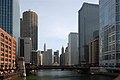
 Clark Street at the Roosevelt Road interchange (October 2022) | |
| Coordinates | 41°56′54″N 87°39′27″W / 41.9483°N 87.6574°W |
|---|---|
| South end | Cermak Road (2200 S) |
| North end | Howard Street (7600 N) at the Chicago/Evanston border |
| Construction | |
| Inauguration | 1830 |
Clark Street is a
History

Clark Street is named for George Rogers Clark, an American Revolutionary War soldier who captured much of the Northwest Territory from the British.[1][2] Within the Chicago Loop Clark Street is one of the original streets laid out by James Thompson in his 1830 plat of Chicago.[3] North of the Loop, from North Avenue, it roughly follows part of the path of an Indian trail called Green Bay trail (later Green Bay Road) that ran all the way to Green Bay, Wisconsin.[4] In the 1950s Clark Street between Ohio and Armitage Streets was a substantial neighborhood barrio home to the first Puerto Ricans in Chicago. It was unofficially known as La Clark by the Puerto Ricans that lived there arriving from the steel mills of Indiana and rural migrant camps. This was primarily during the Great Migration and war effort during and after World War II. They worked at the downtown hotels, the meat packing plants and the nearby factories then located near downtown industrial areas. Many original members of the Young Lords, a former street gang that transformed into a Latino civil and human rights movement, were sons and daughters of these immigrants and grew up in La Clark.
Points of interest
From the intersection with Ashland Avenue south to Ainslie Street, Clark Street passes through the
Transit
The CTA 22 bus offers 24/7 service down Clark St from Howard St. to Harrison St. In addition, it touches the "L" at
Major intersections
The entire route is in Cook County.
| Location | mi[8] | km | Destinations | Notes | |
|---|---|---|---|---|---|
Chicago line | 0.0 | 0.0 | Howard Street | Northern terminus; roadway continues as Chicago Avenue | |
Chicago | 2.1 | 3.4 | |||
| 3.0 | 4.8 | ||||
| 4.6 | 7.4 | ||||
| 7.8 | 12.6 | ||||
| 9.6 | 15.4 | Clark Street Bridge | |||
| 11.0 | 17.7 | W Roosevelt Road | Interchange | ||
| 12.0 | 19.3 | W Cermak Road | Southern terminus | ||
| 1.000 mi = 1.609 km; 1.000 km = 0.621 mi | |||||
Gallery
-
 the intersection of Clark and Halsted in 2009, Clark is on the left
 -
 Clark and South Water Streets in 1865
 -
 Clark Street passes by Wrigley Field
 -
 A view of Clark Street inAndersonville
 -
 Clark Street bridge in 2007
 -
 The Wieners Circle hot dog stand is on 2622 North Clark
 -

-
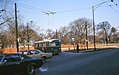 North and Clark in 1969
.jpg)

.jpg)


.jpg)
References
Notes
- ^ a b c Hayner & McNamee 1988, p. 23
- ^ "George Rogers Clark and Clark Street". Chicago Daily Tribune. April 1, 1927.
- ^ Quaife 1923, pp. 18–19
- ^ Quaife 1923, pp. 106–107
- ^ "National Register of Historic Places Listings". National Register of Historic Places. National Park Service. 2010-03-26.
- ^ "How Moran Gang Was Wiped Out". Chicago Daily Tribune. February 15, 1929.
- ^ "RTA System Map" (PDF). Regional Transportation Authority. Retrieved August 9, 2023.
- ^ "Clark Street Overview".
Bibliography
- Hayner, Don; McNamee, Tom (1988). Streetwise Chicago: A History of Chicago Street Names. Loyola University Press. OCLC 18070957.
- Quaife, Milo Milton (1923). Chicago's Highways, Old and New: From Indian Trail to Motor Road. D.F. Keller & Company. OCLC 1686569. Retrieved August 22, 2010.