
Geography of Saint Kitts and Nevis
17°20′N 62°45′W / 17.333°N 62.750°W
This article needs additional citations for verification. (May 2019) |

Geology
The island of
Nevis is a volcanic island that began its formation in mid-
Statistics

Map references: Central America and the Caribbean
Area:
total:
261 km2 (Saint Kitts 168 km2; Nevis 93 km2)
land:
261 km2
water:
0 km2
Area - comparative: two thirds the size of the island of Barbados
Coastline: 135 km
Maritime claims:
continental shelf:
200 nautical miles (370 km) or to the edge of the continental margin
territorial sea:
12 nautical miles (22 km)
contiguous zone:
24 nautical miles (44 km)
exclusive economic zone:
200 nautical miles (370 km)
Climate: tropical tempered by constant sea breezes; little seasonal temperature variation; rainy season (May to November)
Extreme points:
Northernmost point: Unnamed headland at Dieppe Bay Town, Saint Kitts
Southernmost point: Devil's Cave, Saint John Figtree Parish, Nevis
Westernmost point: Western cape of Saint Kitts, Saint Anne Sandy Point Parish
Easternmost point: Eastern cape of Nevis, Saint James Windward Parish
lowest point: Caribbean Sea 0 m
highest point: Mount Liamuiga 1,156 m
Natural resources: arable land
Land use:
arable land:
19.44%
permanent crops:
2.78%
other:
77.78% (2005)
Natural hazards: hurricanes (July to October)
Environment - international agreements:
party to:
Climate
By the Köppen climate classification, St. Kitts has a tropical savanna climate (Köppen Aw) and Nevis has a tropical monsoon climate (Köppen Am).[2] Mean monthly temperatures in Basseterre varies little from 23.9 °C (75.0 °F) to 26.6 °C (79.9 °F). Yearly rainfall is approximately 2,400 millimetres (90 in), although it has varied from 1,356 millimetres (53.4 in) to 3,183 millimetres (125.3 in) in the period 1901–2015.[3]
| Climate data for Saint Kitts and Nevis (1991–2015) | |||||||||||||
|---|---|---|---|---|---|---|---|---|---|---|---|---|---|
| Month | Jan | Feb | Mar | Apr | May | Jun | Jul | Aug | Sep | Oct | Nov | Dec | Year |
| Daily mean °C (°F) | 23.9 (75.0) |
23.8 (74.8) |
24.0 (75.2) |
24.7 (76.5) |
25.5 (77.9) |
26.2 (79.2) |
26.3 (79.3) |
26.6 (79.9) |
26.4 (79.5) |
26.0 (78.8) |
25.4 (77.7) |
24.4 (75.9) |
25.3 (77.5) |
| Average precipitation mm (inches) | 150 (5.9) |
102 (4.0) |
99 (3.9) |
153 (6.0) |
219 (8.6) |
181 (7.1) |
214 (8.4) |
232 (9.1) |
222 (8.7) |
289 (11.4) |
286 (11.3) |
225 (8.9) |
2,372 (93.3) |
| Source: Climate Change Knowledge Portal[3] | |||||||||||||
Gallery
-
 Downtown Basseterre
 -
 Downtown Basseterre
 -
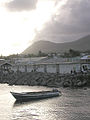 Fishing boat, Basseterre harbor
 -
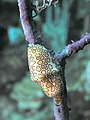 Flamingo Tongue shell on a Sea Fan
 -
 Divers and anemone on the MV River Taw wreck
 -
 Juvenile French Angelfish near a sunken van
 -
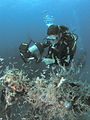 Diver and fish, MV River Taw wreck
 -
 Diver and sponges
 -
 Royal Gramma or Fairy Basslet


See also
References
- ^ "Saint Kitts and Nevis", The World Factbook, Central Intelligence Agency, 2024-03-05, retrieved 2024-03-22
- ^ "Climate of Saint Kitts and Nevis: Temperature, Climograph, Climate table for Saint Kitts and Nevis – Climate-Data.org". Climate-data.org. Alexander Merkel. Retrieved 15 March 2018.
- ^ a b "Country Historical Climate – St. Kitts & Nevis". Climate Change Knowledge Portal. The World Bank Group. Archived from the original on 6 November 2018. Retrieved 15 March 2018.
![]() This article incorporates public domain material from The World Factbook.
This article incorporates public domain material from The World Factbook.
| Sovereign states |  | |
|---|---|---|
Dependencies and other territories |
| |