
Coalhouse Fort
| Coalhouse Fort | |
|---|---|
| East Tilbury, Essex, England | |
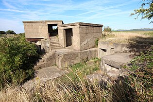
 Exterior of Coalhouse Fort | |
 Coalhouse Fort | |
| Coordinates | 51°27′54″N 00°25′58″E / 51.46500°N 0.43278°E |
| Type | Fortification |
| Site information | |
| Owner | Thurrock Council |
| Controlled by | Coalhouse Fort Project |
| Condition | Intact |
| Site history | |
| Built | 1861–74 |
| Built by | United Kingdom |
| In use | 1874–1949 |
| Materials | Concrete, granite, cast iron, brick, Kentish ragstone |
Coalhouse Fort is an artillery fort in the
The fort's armament was revised several times during its 70 years of
Decommissioned in 1949, the fort was used as a storehouse for a shoe factory before it was purchased by the local council. The surrounding land was developed into a public park, but the fort itself fell into dereliction despite its historical and architectural significance. From 1985 it was leased to a voluntary preservation group, the Coalhouse Fort Project, which had been working to restore the fort and use it for heritage and educational purposes. Funding for its restoration was provided in part by the
Development
Early defences

East Tilbury, which stands at the western end of the section of the Thames known as Lower Hope Reach, was fortified long before the building of Coalhouse Fort due to its vulnerability to seaborne attackers. Settlements on both sides of the Thames were raided by the French in 1379 during the
Appeals from the local people led to the Crown agreeing in July 1402 to build an earthen rampart and towers to protect the settlement. The site of these early defences is not known but might have been near where St Catherine's Church now stands. A ditch of unknown date in that vicinity may represent a fragment of the medieval defences.[1]
Henrician defences
The East Tilbury Blockhouse was built partly with stone taken from St Margaret's Chapel in Tilbury, which was dissolved in 1536. Its form is not known but it probably consisted of a brick and stone structure, perhaps in a D-shape, with a rampart and ditch to enclose its landward side. It was recorded as having fifteen iron and brass cannon of various calibres in 1540; these had been increased to 27 by 1539–40. It had a small permanent garrison, consisting of a commander and his deputy, a porter, two soldiers and four gunners. The blockhouse may have been altered in 1545 but in 1553 it was disarmed. Although the corresponding blockhouse at Gravesend continued in use and that at Tilbury was eventually incorporated into Tilbury Fort between 1670 and 1683, the one at East Tilbury seems to have been abandoned before the end of the 16th century.[2] By 1735 it had been inundated by the river and was in ruins.[3] Its site by the shoreline has since been eroded away by tidal action,[2] though it is possible that remains from the blockhouse may still survive under the river mud.[4]
Coalhouse Battery

The June 1687 Raid on the Medway by the Dutch fleet during the Second Anglo-Dutch War exposed the weaknesses of the Thames defences.[2] It took another hundred years for the defences on Gravesend Reach to be improved, in the form of new works at Gravesend and Tilbury built in the 1780s, but even then the potential of forward defence – to prevent enemies accessing the lower Thames – continued to be neglected. It was not until the outbreak of the French Revolutionary Wars that the need for effective forward defence was addressed. Lieutenant Colonel Hartcup of the Royal Engineers carried out a survey of the Thames in 1794 in which he recommended building a triangle of artillery batteries to guard the entrance to Gravesend Reach and the next reach of the river, Lower Hope Reach. Two of the batteries would be located on the south bank at Shornemead, about 1.5 miles (2.4 km) north-west of Higham; at Lower Hope Point, about 1.8 miles (2.9 km) north-west of Cliffe; and on the north bank at East Tilbury, about 0.5 miles (0.8 km) north of the old Henrician blockhouse. The batteries would have a maximum range of about 1.5 miles (2.4 km) and their arcs of fire would overlap, enabling them to support each other.[5]
The new battery was constructed during 1799 on marshy ground a short distance south-east of St Catherine's Church. It took its name from the nearby Coalhouse Point, which was named for a coal wharf that once existed there to serve East Tilbury.[6] The soft soil caused many problems but the work was completed by July of that year. It was equipped with four 24-pounder (pdr.) cannon mounted on traversing carriages, which enabled the gunners to track targets much more easily than had been the case with traditional garrison carriages. The battery faced the river with a semi-circular earthen rampart on which the guns were mounted. A walled-off area to the rear enclosed a barracks, magazine and shot kiln (for heating shot to set wooden ships on fire). The whole structure was surrounded by a polygonal water-filled ditch. It was modified in 1810 to raise the height of the rampart and to add a small expense magazine where ammunition was stored for immediate use. The French did not test the Thames defences, despite an invasion scare in 1804, and the battery was abandoned along with those at Lower Hope Point and Shornemead following Napoleon's final defeat in 1815.[5]
First Coalhouse Fort
Renewed tension between Britain and France in the 1840s led to a modernisation of some of Britain's coastal defences. The batteries at Shornemead and Coalhouse Point were reinstated and upgraded, though the one at Lower Hope Point was never restored. In the case of the Coalhouse battery, it was substantially expanded between 1847 and 1855 to convert it into a fort. The work was slow as the marshy ground caused the foundations to crack and the structure to subside, and the contractor was unsatisfactory.[7]
The new fort was built as an extension to the north-west of the existing battery, and thus took an irregular plan. The rampart was extended to accommodate more guns – a total of seventeen 32-pdrs. – and a much enlarged interior replaced the old barracks and magazine. Caponiers at the east side and firing positions on the other sides facilitated musketry defence against land-based assailants. The fort was surrounded by a wide water-filled ditch. A bridge on the west (landward) side provided the only access route.[7]
Second Coalhouse Fort

By the late 1850s, Britain and France were locked in an arms race. A new generation of increasingly accurate and powerful guns had been developed (of the rifled muzzle loader (RML) and rifled breech loader (RBL) types), mounted on fast-moving, manoeuvrable steam-powered ironclad warships such as the French La Gloire and the British HMS Warrior.[8] Such vessels posed a serious threat to the important naval installations on the Thames, including the victualling yards at Deptford, the armaments works of Woolwich Arsenal, the shipbuilding yards at North Woolwich, and the magazines at Purfleet. It was not possible for large warships to reach central London, as the river was not yet deep enough to take ships of more than 400 tons above Deptford. (Capital dredging later enabled much larger ships to reach as far as the Pool of London.) As the American Civil War was soon to show, it was quite possible for the warships of the day to run past forts and attack up coastal rivers.[9]
The new weapons meant that the existing coastal and riverine forts were rendered largely obsolete. The American Civil War was soon to demonstrate that traditional brick and masonry forts could be reduced to rubble by rifled guns. The government's response was to appoint a Royal Commission on the Defence of the United Kingdom, which published a far-reaching report in 1860.[7] The Royal Commission recommended that a triangle of forts should be established on the lower Thames, east of Gravesend. This would involve replacing the existing Coalhouse Fort on the Essex shore with a new fortification, similarly replacing the existing Shornemead Fort and building the wholly new Cliffe Fort opposite Coalhouse Point, which would replace the abandoned 18th-century battery at Lower Hope Point. The locations of the forts would enable interlocking arcs of fire from their guns.[10] A boom defence and a minefield would be installed off Coalhouse Point in wartime to further boost the strength of the defences.[7]
The design of the new fort was similar to that of the other Royal Commission forts on the Thames, with an arc of granite-faced casemates, reinforced by iron shields. These, it was believed, would be virtually invulnerable to enemy fire. It was originally envisaged that the fort would have two tiers (in a design similar to that of Garrison Point Fort at Sheerness) mounting around 56 guns; 28 in casemates and the rest in barbettes on the fort's roof. Construction began on this basis in July 1861 but as the work progressed the design was changed, leaving the fort with only a single tier of casemates. Like its predecessors, its construction was seriously affected by the poor ground conditions and was disrupted by shifting and cracking foundations. Colonel Charles George Gordon, who was later to die in the siege of Khartoum, supervised its final phases of construction. The fort cost a total of £130,000 to build.[11]
Operational history
19th century

It was originally intended that Coalhouse Fort would be armed with 68-pdr. smooth-bore guns, but these had become obsolete by the time it was completed in 1874. More powerful armour-piercing weapons were required, so the casemates were provided with four
The guns were controlled from a Battery Commander's Post on the roof, from where commands to the gun detachments could be relayed via voice pipes. Three depression range finders were installed on the roof by the late 1890s to aid the guns' targeting. A well-trained crew could fire each gun once every two minutes. Rather than firing all the guns at once, the guns were positioned so that they could be fired in sequence as an enemy ship passed by. When combined with the fire from Shornemead and Cliffe Forts on the Kent shore, this would ensure that constant fire could be maintained from three different sides.[12]
The rapid development of artillery weapons in the late 19th century meant that the casemate style of fortification had become virtually obsolete within a decade of the fort's completion. Its original purpose of defending the river against large warships was taken over by a new East Tilbury Battery, constructed in 1891 about 600 metres (660 yd) to the north-west just outside East Tilbury village. This contained six much more powerful breech-loading (BL) guns on Moncrieff disappearing carriages within concealed emplacements facing east up the river.[15] A similar battery was built at Slough Fort on the Hoo Peninsula a few miles downriver.[16]
At the same time, a new threat had emerged in the shape of the fast and highly manoeuvrable torpedo boat. Large guns were virtually useless against such vessels, so the fort was supplemented with another new battery built in 1893 some 365 metres (399 yd) to the south where 6-pdr. quick-firing guns were installed. Similar batteries were built on the opposite shore at Shornemead and Cliffe Forts.[16]
Early 20th century
By the start of the 20th century the fort's casemates had been put out of use as they were too vulnerable to modern artillery. Instead, part of the fort's front was covered with a sloping glacis made of earth, blocking the casemates and filling the inner defensive ditch. At least one of the front caponiers was also demolished around this time. Most of the old RMLs were retired and replaced with four Mk. VII six-inch BL guns and four 12-pdr quick-firing (QF) BL guns, with ranges of 7 miles (11 km) and 4.5 miles (7.2 km) respectively, mounted on concrete emplacements on the fort's roof. The larger guns were intended to support those at East Tilbury Battery while the smaller ones provided a defence against fast-moving vessels such as destroyers and torpedo boats. Despite their obsolescence, two of the old 12.5-inch RMLs remained at the fort until as late as 1912.[17] They were to be used as "giant blunderbusses" to spray torpedo boats with grapeshot if they got past the other guns.[13]
Coalhouse Fort was manned during the
The fort's armament was reduced during the war as other forts and batteries took over some of its duties. Two of the six-inch guns were shipped across the river to Cliffe Fort in 1914 and the QF guns on the roof were withdrawn. An anti-aircraft battery was established north-west of the fort for defence against Zeppelins and enemy bombers.[18]
1920s to 1940s

Following the end of the war, it was proposed in 1924 that Coalhouse Fort should be re-equipped with 4-inch guns but post-war defence cuts meant that this plan was abandoned. Instead, the fort was reduced to care and maintenance status and East Tilbury Battery was decommissioned in 1930. The continuing development of artillery firepower meant that the forts and batteries further downriver took on an increased responsibility for the forward defences of the Thames. The forts on Gravesend Reach were relegated to a second line of defence.[18]
Coalhouse Fort became an "emergency" battery during the
The fort's defences were also enhanced with two light anti-aircraft guns, including a
By 1944 the threat of invasion had abated and the fort was handed over to the
HMS St Clement became a Combined Operations base
Architecture
Casemates

Coalhouse Fort is exceptionally well-preserved; it provides one of the finest surviving examples of a mid-Victorian armoured casemate fort.[25] It has twelve casemates arranged in a semi-circle facing south and east towards the river, with an annexed open battery facing south-west. The casemates are faced with massive slabs of granite and have iron gun ports to protect the gunners from splinters dislodged by incoming fire.[26]
Although the casemates have been altered over the years, many of their original features survive. None of the guns remain in situ but the metal rails on which they traversed are still in place. The casemates were divided into two sections. During periods of high alert the gun crews would live next to their weapons in the casemates' rear, an area known as the war accommodation. The front of the casemate was the gun emplacement proper, where the loading and firing took place. The iron shield protecting each casemate was fitted with iron bars from which two mantlets made of thick lengths of rope were hung. These protected the gun crew from splinters and smoke. A loading bar above the gun-port enabled the crew to lift the heavy shells and cartridges up to the mouth of the gun. These were dispensed from the magazines below via lifts on either side of the emplacements.[26]
The guns mounted in the open battery were lighter than those in the casemates and were not enclosed but traversed on rails in the open air. A covered section between each emplacement led to an ammunition lift shaft up which the shells and cartridges were raised using lifting gear that still survives.[26]
Improvements to artillery technology necessitated significant changes to the fort's structure towards the end of the 19th century and the start of the 20th. Closely packed casemates of the type built at Coalhouse Fort were vulnerable to new and more powerful types of explosive shells. To alleviate this threat, massive concrete traverses were constructed in the 1880s to isolate each casemate, preventing a shell bursting inside one casemate from affecting its neighbours and causing a cumulative explosion. The construction of concrete gun emplacements on the fort's roof necessitated the installation of circular concrete pillars within the casemates to support the extra weight on the roof. The ammunition lifts were also extended to serve the new roof-mounted guns.[27]
Magazines, barracks and roof


The magazines, situated deep under the casemates, consist of alternating pairs of shell and cartridge rooms accessed via an ammunition passage at the front and a lighting passage behind. Great care was taken to reduce the possibility of an accidental explosion. The magazine workers wore special clothes and shoes to eliminate the risk of striking sparks and the floors of the cartridge stores were covered by wooden battens. The lighting was provided from oil lamps situated behind glass windows and accessed only from the lighting passage, which was physically separated from the rest of the magazine. Sets of lifting gear enabled the workers to winch the cartridges and ammunition up to the casemates, with which they could communicate via voice tubes.[28]
A defensible barracks made of brick, faced in
An irregularly shaped parade area occupies the middle of the fort, which is divided by a sloping ramp leading up to the casemates. A small brick building – originally used as a laboratory or shell-filling facility – stands to the right of the ramp.[26] The fort is entered through a single gateway on its west side, protected against landward attackers by a caponier. The front of the fort was surrounded by a dry ditch, in which there were originally four caponiers to provide musketry defence. A very wide outer wet ditch blocked access from the riverside.[26]
The roof of the fort, accessed via steps up from the open battery, was altered substantially during the first half of the 20th century to accommodate new guns and other structures. These include emplacements for 5.5-inch and 6-inch guns as well as 12-pdrs, searchlight positions, shelters, an observation post, a fire control building, a machine-gun parapet on the north caponier and a Royal Navy monitoring station.[27]
External facilities
The fort was linked to a jetty, Coalhouse Wharf, on the riverside a short distance to the south. A
-
 Detached wing battery (1893)
 -
 Radar tower
(Second World War) -
 Extended Defence Officer's Post (Second World War)


A two-storey concrete structure just north of the fort was used during the Second World War as an Extended Defence Officer's Post to control the minefield outside the fort. It could also serve as a pillbox. A corresponding post stood on the Kent shore. A small concrete structure a further 148 feet (45 m) north-east of the fort may have been an electrical power house.[32] The minefield was overlooked by a hexagonal radar tower about 1,300 feet (400 m) south of the fort, consisting of a concrete structure on a metal frame on which the radar array was mounted. This stands atop a brick building in which the power plant, electrical equipment radar screen and personnel accommodation were located.[33] It was only used for a short time between 1941 and 1943 and is now considered structurally unsafe.[31] Situated nearby is the detached battery built in 1893 to mount four 6-pdr. quick-firing guns. It is well-preserved and the emplacements, ready-use lockers and magazines are all still largely intact.[32]
Current status

After being decommissioned, Coalhouse Fort was leased and used as a storage facility by
Coalhouse Fort and the adjacent artillery defences to the south of the fort were collectively designated as a scheduled monument in 1962, in recognition of their status as "a remarkable group of defensive sites".[35]
The fort was leased to the Coalhouse Fort Project, a heritage charity operated by volunteers between 1985 and 2020. The project undertook the gradual restoration of the fort and held regular open days. Various items of 20th century military equipment were displayed in the interior of the fort; the casemates housed reconstructions and small military-related museums. The project was highly commended in the British Archaeological Awards and the fort has featured both in the BBC series Restoration and in the 2005 film Batman Begins,[34] in which it stood in for a Bhutanese prison in the first five minutes of the film. The British director Christopher Nolan had seen the TV series and decided that he wanted to set the film's opening scenes in the fort.[36]
The poor condition of parts of the structure and its state of slow decay led to it be listed in 2008 on the
In January 2020, the Coalhouse Fort Project was discontinued in recognition of its success in saving and restoring the fort, leaving the site's future direction to Thurrock Council and the Heritage Lottery Fund.[42]
References
- ^ a b c Smith, Victor T. C. (1985). Coalhouse Fort and the Artillery Defences at East Tilbury. Coalhouse Fort Project. p. 4.
- ^ a b c d Smith (1985), p. 5
- ^ a b "Coalhouse Fort". PastScape. Historic England. Archived from the original on 7 April 2016. Retrieved 25 July 2015.
- ISBN 978-1-4728-0380-1.
- ^ a b Smith (1985), p. 8
- ISBN 978-0-9548010-0-7.
- ^ a b c d Smith (1985), p. 10
- ISBN 978-0-7277-2875-3.
- ^ Wilson, J.D. (December 1963). "Later Nineteenth Century Defences of the Thames, including Grain Fort". Journal of the Society for Army Historical Research. XLI (168): 182.
- ISBN 978-0-7478-0651-6.
- ^ Smith (1985), p. 13
- ^ a b Smith (1985), p. 14
- ^ ISBN 978-0-7524-9237-7.
- ^ Smith (1985), p. 15
- ^ Smith (1985), p. 16
- ^ a b c Smith (1985), p. 17
- ^ a b c Smith (1985), p. 23
- ^ a b Smith (1985), p. 29
- ^ a b Smith (1985), p. 30
- ISBN 978-1861762160.
- ^ a b c d Smith (1985), p. 31
- ^ a b Smith (1985), p. 34
- ISBN 978-1-84884-678-4.
- ISBN 978-1-903071-15-1.
- ^ Historic England. "Coalhouse Fort battery and artillery defences (1013943)". National Heritage List for England. Retrieved 24 July 2015.
- ^ a b c d e f Smith (1985), p. 36
- ^ a b Smith (1985), p. 37
- ^ Smith (1985), pp. 15, 37
- ^ Smith (1985), pp. 15, 36
- ISBN 978-0-7509-0384-4.
- ^ a b Smith (1985), p. 41
- ^ a b Smith (1985), p. 38
- ^ Smith (1985), p. 39
- ^ a b "Historical places in Thurrock – Coalhouse Fort, East Tilbury". Thurrock.gov.uk. Thurrock Council. Archived from the original on 12 June 2015. Retrieved 25 July 2015.
- ^ "Coalhouse Fort battery and artillery defences, Non Civil Parish - 1013943 | Historic England". historicengland.org.uk. Retrieved 22 June 2022.
- ^ a b "Funding boost for Coalhouse Fort restoration project". BBC. 19 January 2010. Retrieved 25 July 2015.
- ^ "Coalhouse Fort on 'at risk' list". Thurrock Gazette. 9 July 2008. Retrieved 25 July 2015.
- ^ "Coalhouse Fort restoration underway". Thurrock Gazette. 12 March 2009. Retrieved 25 July 2015.
- ^ Abbott, Matt (18 December 2013). "£1million works could see Coalhouse Fort could become "a mecca for history buffs across the world"". Thurrock Gazette. Retrieved 25 July 2015.
- ^ Publicity leaflet providing a short guide to the path
- ^ "Coalhouse Fort, Tilbury – Thurrock (UA)". Historic England. Retrieved 27 March 2018.
- ^ "From the Coalhouse Fort Project Management Committee: Charity to close". Coalhouse Fort Project. 26 January 2020. Retrieved 5 January 2022.
External links
- Coalhouse Fort Park (Thurrock Council)
- Coalhouse Fort Picture Gallery
- Victorian Forts data sheet